NEON Goes Mobile: Five Ways to Use the MDPs
March 12, 2021
Wish you could have a NEON field station at your study site? With the Mobile Deployment Platforms (MDPs), you can!
The MDPs are mobile, modular NEON field stations that can go practically anywhere with road access. They allow researchers to plug into the NEON network and leverage the standardized, validated instrument systems used across the Observatory for their own research programs. The MDPs put the power of NEON's instrumented systems into the hands of individual Principal Investigators (PIs), academic institutions, and research organizations.
The NEON program has five MDPs consisting of a mobile field instrument hut, flux tower (up to 100 feet), soil sensor array, and aquatic sensor station. The aquatic and terrestrial components can be deployed together or individually to collect a variety of meteorological, soil, and water measurements – they can also be customized with additional sensors and instruments.
What, exactly, can you do with a NEON MDP? We're glad you asked. The possibilities for ecological research with the MDPs are nearly limitless, and we are sure that the science community will find uses for them that we have not yet imagined. But here are five exciting scenarios that we envision.
1. Bring NEON Measurements to Experimental Sites
The NEON program does not perform any manipulative experiments of the environment; our mission is to gather long-term data at sites across the country for others in the scientific community to use and analyze. But with the MDPs, you can bring standardized NEON measurements to your experimental site. For example, you could:
- Manipulate nutrient levels at a stream site and monitor the impact on water chemistry and quality.
- Measure carbon and nutrient fluxes following wildfires or controlled burn experiments.
- Measure the effects of large scale warming, precipitation, or CO2 enrichment experiments.
- Monitor the environmental impact of different crop rotation, fertilization, or grazing regimens.
The MDPs provide a set of NEON-calibrated and ready-to-go instruments and sensors (terrestrial, aquatic, or both) to monitor all kinds of experimental studies. The data products collected can be correlated and compared to data products generated by instrument systems at NEON field sites across the country. The NEON sites can act as a form of long-term baseline or can provide researchers with a broader context for their results from MDPs.
2. Monitor Response to Disturbances and Rapidly Changing Ecosystems
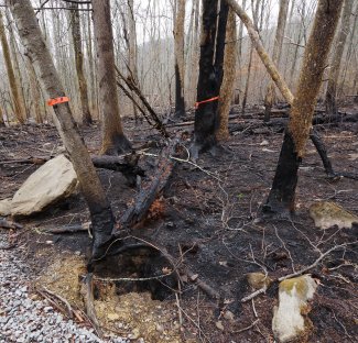
Photos of wildfire damage at GRSM.
Ecological disturbances such as wildfires, floods, hurricanes, and tornados create opportunities to collect rich ecological data to support our understanding of how ecosystems recover from various events. Few of those events occur where the NEON field sites (or other network sites) happen to be located. But the MDPs can be rapidly deployed to collect a broad range of ecological data in the weeks and months after a major disturbance.
The MDPs can also be used to monitor ecosystems that are rapidly changing due to land use, climate change, or the incursion of invasive species. For example, they could be used to monitor:
- Permafrost degradation
- Coastal erosion
- Areas experiencing beetle kill
- Areas experiencing changes in wildfire patterns
- Terrestrial and aquatic ecosystem changes related to long-term drought
- Impact of fertilizers or pollutants on lake chemistry or water quality
- Wetland loss
- Forest regrowth after logging
- Border areas where human activity encroaches on natural habitats
3. Link Networks by Bringing NEON Measurements to Other Network Sites
Several NEON field sites are colocated with other network field sites, including sites for the Long-Term Ecological Research (LTER) Network, the Long-Term Agroecosystem Research (LTAR) Network,AmeriFlux, and many others. Colocation of sites allows networks to piggy-back on each other's data, providing broader context for both networks. They also enable the science community to create linkages between data products from other networks and the NEON data products to support data analysis across networks.
The MDPs allow researchers to expand these colocation opportunities. By locating a NEON MDP at a long-term research site for another network or program for a year or two, a PI can create a kind of "Rosetta Stone" to enable comparison and analysis using data from both networks. This provides a number of advantages for the networks and for the research community at large:
- Extends NEON data with historical data from older ecological networks.
- Allows cross-comparison of data from sites across networks
- Enables collection of additional data products (e.g., meteorological, carbon flux, water chemistry) not currently collected by a network
4. Validate Data and Test New Instrument Technologies
MDPs can be used to validate data and test new instrument systems for other networks, agencies, and individual PIs. For example, NASA used data from the NEON field sites to validate satellite data for their Soil Moisture Active/Passive (SMAP) program. With the MDPs, researchers can capture data for calibration or validation of remote sensing networks from anywhere, not just the existing NEON field sites. The MDPs can be placed wherever they are needed to overlap with satellite, airplane, or drone flyovers.
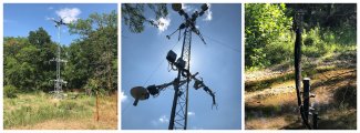
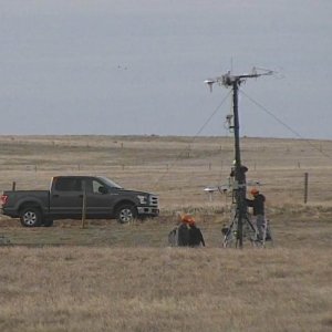
Mobile deployment platforms at different NEON sites
The MDPs can also be deployed as a testbed for new sensor technologies or advanced instrument systems. New instruments can be easily added to the mobile tower unit or aquatic sensor station. Data from the existing instrument systems can be used to calibrate or validate these new technologies.
MDPs can be used for a variety of testing and validation projects, including:
- Ground-truthing of satellite, airplane, or drone data
- Validating new instrument systems against NEON's standardized instruments
5. Capture Spatial Gaps or Site Heterogeneity
The NEON program has 81 field sites located in 20 ecoclimatic Domains across the U.S., from the Alaskan Tundra to the Atlantic Neotropical region. That's a lot of sites representing many different climate zones, landscapes, and habitats. However, there are many unique habitats and areas of interest that the NEON spatial design simply cannot cover, including coastal environments and urban or suburban landscapes.
The MDPs provide an opportunity for researchers to capture NEON data anywhere. You could:
- Collect data for a unique microhabitat or ecosystem that is not represented within NEON's spatial design
- Use multiple MDPs to collect data across physical or environmental gradients
Interested in Deploying an MDP? Here's How
MDPs are available to PIs and research organizations through the NEON program on a cost-recoverable basis, meaning the requestor must cover only the actual costs of deployment and management of the platform. The funds enable the NEON program to deliver, setup, manage, and remove the MDP at the end of the project period.
Research grants are available through the National Science Foundation (NSF) and other sources to cover the cost of deployment, such as the NSF RAPID and EAGER grant programs and Macrosystems Biology and NEON-Enabled Science (MSB-NES) grant. Funding can be sought through opportunities from agencies including NASA (e.g., ROSES, Terrestrial Ecology Program) and USDA.
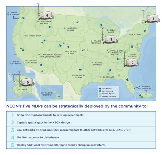
Hypothetical MDP use cases. See below to request a MDP for research or educational purposes.
To get started, follow the guidelines for the NEON Assignable Asset Program and complete an MDP Request Form:
Questions and MDP requests can be submitted to AssignableAssetRequests@BattelleEcology.org. We are also happy to set up a web meeting or call to discuss your project. Contact us and let's talk!
We can't wait to see how the MDPs will be used by the research community in the years ahead.