NSF NEON | Open Data to Understand our Ecosystems logo

Main navigation

  • About Us
    • Overview
      • Spatial and Temporal Design
      • History
    • Vision and Management
    • Advisory Groups
      • Science, Technology & Education Advisory Committee
      • Technical Working Groups (TWGs)
    • FAQ
    • Contact Us
      • Field Offices
    • User Accounts
    • Staff

    About Us

  • Data & Samples
    • Data Portal
      • Explore Data Products
      • Data Availability Charts
      • Spatial Data & Maps
      • Document Library
      • API & GraphQL
      • Prototype Data
      • External Lab Data Ingest (restricted)
    • Samples & Specimens
      • Discover and Use NEON Samples
        • Sample Types
        • Sample Repositories
        • Sample Explorer
        • Megapit and Distributed Initial Characterization Soil Archives
        • Excess Samples
      • Sample Processing
      • Sample Quality
      • Taxonomic Lists
    • Collection Methods
      • Protocols & Standardized Methods
      • Airborne Remote Sensing
        • Flight Box Design
        • Flight Schedules and Coverage
        • Daily Flight Reports
          • AOP Flight Report Sign Up
        • Camera
        • Imaging Spectrometer
        • Lidar
      • Automated Instruments
        • Site Level Sampling Design
        • Sensor Collection Frequency
        • Instrumented Collection Types
          • Meteorology
          • Phenocams
          • Soil Sensors
          • Ground Water
          • Surface Water
      • Observational Sampling
        • Site Level Sampling Design
        • Sampling Schedules
        • Observation Types
          • Aquatic Organisms
            • Aquatic Microbes
            • Fish
            • Macroinvertebrates & Zooplankton
            • Periphyton, Phytoplankton, and Aquatic Plants
          • Terrestrial Organisms
            • Birds
            • Ground Beetles
            • Mosquitoes
            • Small Mammals
            • Soil Microbes
            • Terrestrial Plants
            • Ticks
          • Hydrology & Geomorphology
            • Discharge
            • Geomorphology
          • Biogeochemistry
          • DNA Sequences
          • Pathogens
          • Sediments
          • Soils
            • Soil Descriptions
    • Data Notifications
    • Data Guidelines and Policies
      • Acknowledging and Citing NEON
      • Publishing Research Outputs
      • Usage Policies
    • Data Management
      • Data Availability
      • Data Formats and Conventions
      • Data Processing
      • Data Quality
      • Data Product Revisions and Releases
        • Release 2021
        • Release 2022
        • Release 2023
      • NEON and Google
      • Externally Hosted Data

    Data & Samples

  • Field Sites
    • About Field Sites and Domains
    • Explore Field Sites
    • Site Management Data Product

    Field Sites

  • Impact
    • Observatory Blog
    • Case Studies
    • Spotlights
    • Papers & Publications
    • Newsroom
      • NEON in the News
      • Newsletter Archive
      • Newsletter Sign Up

    Impact

  • Resources
    • Getting Started with NEON Data & Resources
    • Documents and Communication Resources
      • Papers & Publications
      • Document Library
      • Outreach Materials
    • Code Hub
      • Code Resources Guidelines
      • Code Resources Submission
      • NEON's GitHub Organization Homepage
    • Learning Hub
      • Science Videos
      • Tutorials
      • Workshops & Courses
      • Teaching Modules
      • Faculty Mentoring Networks
      • Data Education Fellows
    • Research Support and Assignable Assets
      • Field Site Coordination
      • Letters of Support
      • Mobile Deployment Platforms
      • Permits and Permissions
      • AOP Flight Campaigns
      • Excess Samples
      • Assignable Assets FAQs
    • Funding Opportunities

    Resources

  • Get Involved
    • Advisory Groups
      • Science, Technology & Education Advisory Committee
      • Technical Working Groups
    • Upcoming Events
    • Past Events
    • NEON Ambassador Program
    • Collaborative Works
      • EFI-NEON Ecological Forecasting Challenge
      • NCAR-NEON-Community Collaborations
      • NEON Science Summit
      • NEON Great Lakes User Group
    • Community Engagement
    • Science Seminars and Data Skills Webinars
    • Work Opportunities
      • Careers
      • Seasonal Fieldwork
      • Postdoctoral Fellows
      • Internships
        • Intern Alumni
    • Partners

    Get Involved

  • My Account
  • Search

Search

Collection Methods

  • Protocols & Standardized Methods
  • Airborne Remote Sensing
  • Automated Instruments
  • Observational Sampling

Breadcrumb

  1. Data & Samples
  2. Collection Methods
  3. Airborne Remote Sensing

Airborne Remote Sensing

AOP remote sensing banner

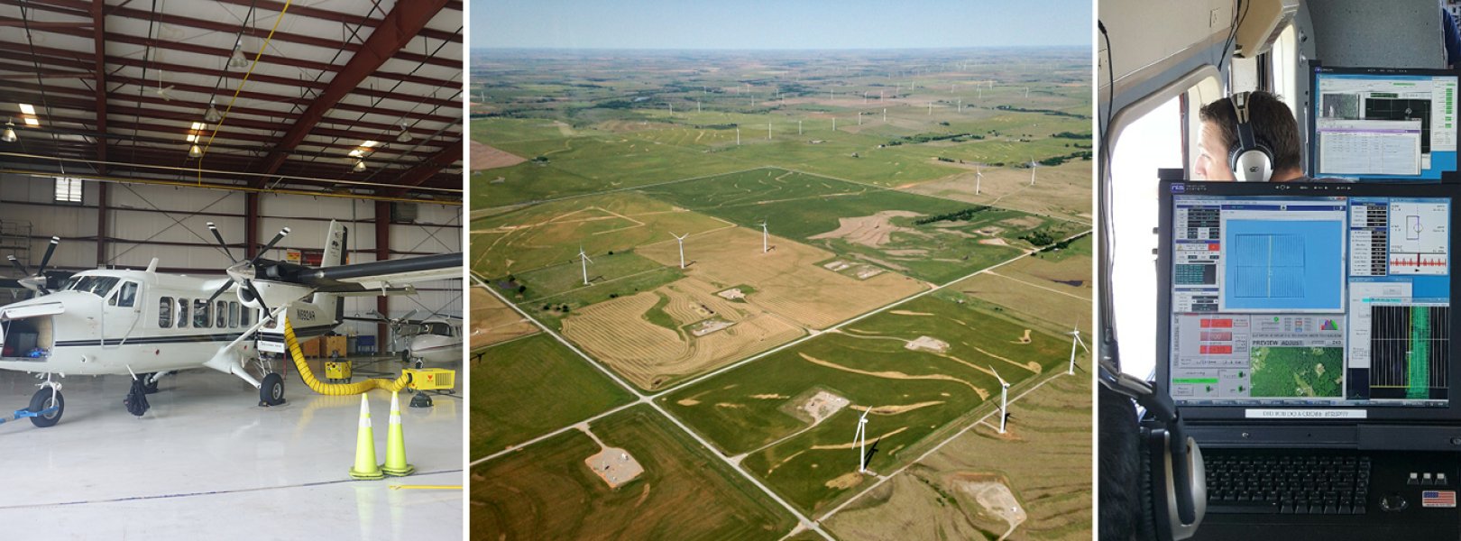
Airborne remote sensing surveys are conducted over NEON field sites during peak greenness and will provide quantitative information on land cover and changes to ecological structure and chemistry, including the presence and effects of invasive species. The surveys are supported by the NEON Airborne Observation Platform (AOP), a synergistic collection of earth observation instruments installed into a light aircraft designed to collect high resolution remote sensing data at low altitude. The intention of the AOP is to collect regional scale landscape information at the NEON field sites. The AOP maps areas where NEON's observational and instrumented sampling is occurring and allows relationships to be drawn between NEON's detailed in-situ observations to the broader environmental and ecological conditions.

Payload Sensors

The AOP consists of three complete and comparable instrument payloads. Typically, two of the payloads are dedicated to collections of the NEON field sites while the third is dedicated to NEON's Assignable Asset program which support externally driven research.
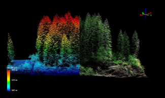
 The primary sensors on each payload include

1) A discrete and full-waveform lidar to provide three-dimensional structural information of the landscape,
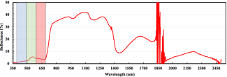
2) An imaging spectrometer to allow discrimination of land cover types and chemical content of vegetation,
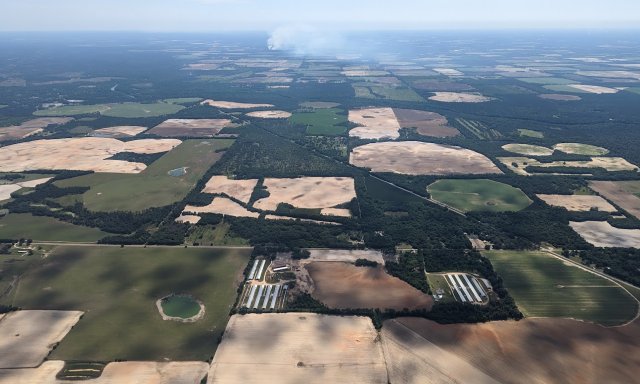
3) A high-resolution digital camera to provide spatially accurate and detailed contextual information, and

4) A GPS antenna and receiver and Inertial Measurement Unit (IMU) to provide high-accuracy positioning and orientation of the aircraft.

The sensors for each payload are calibrated and validated annually through a series of rigorous lab observations and in-flight testing and verification procedures. The AOP sensors are mounted in Twin Otter aircrafts which can accommodate the high volume and weight of the AOP sensors and fly at low altitudes and speeds. All sensors are rigidly co-mounted in the aircraft which provides high relative spatial consistency between observations from individual sensors. The sensor payload remains installed in the aircraft for the duration of the flight season which typically occurs between March and September to correspond to peak greenness across the continent. The AOP collects data at a subset of the NEON sites each year, surveying a flight box that is a minimum of 100 km2 around each site. The current year's schedule is typically released in January. Current and previous schedules can be found at the AOP Flight Schedules and Coverage page.

Data Products

The AOP produces 29 of the NEON data products. The products are separated into categories of Level 1, Level 2, and Level 3 (L1, L2, L3). L1 represents the least processed data products with additional processing steps undertaken to transition the L1 data to L2 and L3. Broadly, the L1 and L2 products are provided by individual aircraft flight line, while L3 products are provided in 1 km by 1 km tiles. Generally, the data volume for L1 products is the highest and decreases for L2 and L3 products. Details of the different products within each Level can be found in the individual webpages for each sensor. All AOP data products can be found on NEON's Data Portal.

Related Resources

  • The NEON education team provides an array of tools for visualizing and working with the AOP data. You can learn more about these tools at NEON's data resources page.
  • You can view or subscribe to our Daily Flight Reports (generated during the flight season).
 
Related Content
AOP Flight Campaigns
Airborne Remote Sensing Data Quality TWG
NEON Logo

Follow Us:

Join Our Newsletter

Get updates on events, opportunities, and how NEON is being used today.

Subscribe Now

Footer

  • My Account
  • About Us
  • Newsroom
  • Contact Us
  • Terms & Conditions
  • Careers

Copyright © Battelle, 2019-2020

The National Ecological Observatory Network is a major facility fully funded by the National Science Foundation.

Any opinions, findings and conclusions or recommendations expressed in this material do not necessarily reflect the views of the National Science Foundation.