NSF NEON | Open Data to Understand our Ecosystems logo

Main navigation

  • About Us
    • Overview
      • Spatial and Temporal Design
      • History
    • Vision and Management
    • Advisory Groups
      • Science, Technology & Education Advisory Committee
      • Technical Working Groups (TWGs)
    • FAQ
    • Contact Us
      • Field Offices
    • User Accounts
    • Staff

    About Us

  • Data & Samples
    • Data Portal
      • Explore Data Products
      • Data Availability Charts
      • Spatial Data & Maps
      • Document Library
      • API & GraphQL
      • Prototype Data
      • External Lab Data Ingest (restricted)
    • Samples & Specimens
      • Discover and Use NEON Samples
        • Sample Types
        • Sample Repositories
        • Sample Explorer
        • Megapit and Distributed Initial Characterization Soil Archives
        • Excess Samples
      • Sample Processing
      • Sample Quality
      • Taxonomic Lists
    • Collection Methods
      • Protocols & Standardized Methods
      • Airborne Remote Sensing
        • Flight Box Design
        • Flight Schedules and Coverage
        • Daily Flight Reports
          • AOP Flight Report Sign Up
        • Camera
        • Imaging Spectrometer
        • Lidar
      • Automated Instruments
        • Site Level Sampling Design
        • Sensor Collection Frequency
        • Instrumented Collection Types
          • Meteorology
          • Phenocams
          • Soil Sensors
          • Ground Water
          • Surface Water
      • Observational Sampling
        • Site Level Sampling Design
        • Sampling Schedules
        • Observation Types
          • Aquatic Organisms
            • Aquatic Microbes
            • Fish
            • Macroinvertebrates & Zooplankton
            • Periphyton, Phytoplankton, and Aquatic Plants
          • Terrestrial Organisms
            • Birds
            • Ground Beetles
            • Mosquitoes
            • Small Mammals
            • Soil Microbes
            • Terrestrial Plants
            • Ticks
          • Hydrology & Geomorphology
            • Discharge
            • Geomorphology
          • Biogeochemistry
          • DNA Sequences
          • Pathogens
          • Sediments
          • Soils
            • Soil Descriptions
    • Data Notifications
    • Data Guidelines and Policies
      • Acknowledging and Citing NEON
      • Publishing Research Outputs
      • Usage Policies
    • Data Management
      • Data Availability
      • Data Formats and Conventions
      • Data Processing
      • Data Quality
      • Data Product Revisions and Releases
        • Release 2021
        • Release 2022
        • Release 2023
      • NEON and Google
      • Externally Hosted Data

    Data & Samples

  • Field Sites
    • About Field Sites and Domains
    • Explore Field Sites
    • Site Management Data Product

    Field Sites

  • Impact
    • Observatory Blog
    • Case Studies
    • Spotlights
    • Papers & Publications
    • Newsroom
      • NEON in the News
      • Newsletter Archive
      • Newsletter Sign Up

    Impact

  • Resources
    • Getting Started with NEON Data & Resources
    • Documents and Communication Resources
      • Papers & Publications
      • Document Library
      • Outreach Materials
    • Code Hub
      • Code Resources Guidelines
      • Code Resources Submission
      • NEON's GitHub Organization Homepage
    • Learning Hub
      • Science Videos
      • Tutorials
      • Workshops & Courses
      • Teaching Modules
      • Faculty Mentoring Networks
      • Data Education Fellows
    • Research Support and Assignable Assets
      • Field Site Coordination
      • Letters of Support
      • Mobile Deployment Platforms
      • Permits and Permissions
      • AOP Flight Campaigns
      • Excess Samples
      • Assignable Assets FAQs
    • Funding Opportunities

    Resources

  • Get Involved
    • Advisory Groups
      • Science, Technology & Education Advisory Committee
      • Technical Working Groups
    • Upcoming Events
    • Past Events
    • NEON Ambassador Program
    • Collaborative Works
      • EFI-NEON Ecological Forecasting Challenge
      • NCAR-NEON-Community Collaborations
      • NEON Science Summit
      • NEON Great Lakes User Group
    • Community Engagement
    • Science Seminars and Data Skills Webinars
    • Work Opportunities
      • Careers
      • Seasonal Fieldwork
      • Postdoctoral Fellows
      • Internships
        • Intern Alumni
    • Partners

    Get Involved

  • My Account
  • Search

Search

Instrumented Collection Types

  • Meteorology
  • Phenocams
  • Soil Sensors
  • Ground Water
  • Surface Water

Breadcrumb

  1. Data & Samples
  2. Collection Methods
  3. Automated Instruments
  4. Instrumented Collection Types
  5. Phenocams

Phenocams

Images from NEON phenocams

Phenology is the study of reoccurring life cycle events that are driven by environmental factors. In this case, the targeted events are related to seasonal changes in above canopy and understory vegetation (e.g. onset of growth and leaf senescence). The timing of these events is driven by both short- and long-term variability in climate and is valuable in understanding the effects of climate change.

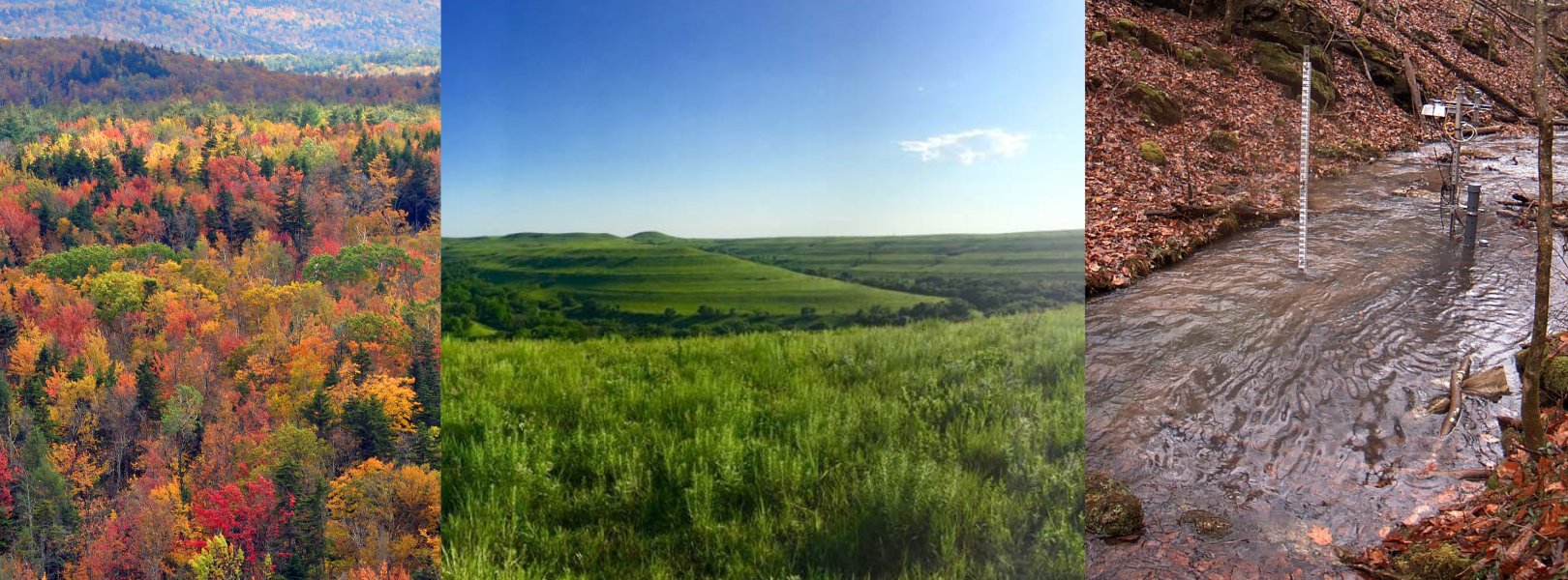
A "phenocam" is a digital camera capturing time-lapse images of foliage which can be used to generate quantitative measures of plant phenology. Over time, these data provide a near-continuous visual record of canopy change and environmental conditions. NEON uses a Stardot NetCam CS CAM-SEC5IR-B to collect RGB and IR images every 15 minutes at each of its terrestrial and aquatic field sites. Over time, these data will reveal trends in the greening and senescence of trees, herbs, and shrubs.

Phenocam imagery is not only important for tracking plant phenology; NEON scientists also place several snow gauges, appearing as yard sticks sticking out of the ground, within the field of view (FOV) of the lower cameras. Users are able to use the images of these snow gauges to estimate snow depth over the non-growing season. Understanding the dynamics of snow cover are important because snow cover and snow melt have an important influence on things like soil temperature, gas exchange between the soil and the atmosphere, and nutrient cycling.

NEON works closely with the PhenoCam Network and has adopted its standards and protocols for instrumentation and instrument configuration as well as data processing. Specifically, NEON employs the standard PhenoCam Network Stardot NetCam CS CAM-SEC5IR-B in conjunction with the PhenoCam Installation Tool to configure all NEON cameras and ensure high quality data capture across the Observatory. Images collected by NEON's phenocams are uploaded to the PhenoCam Network servers where they are processed into a series of standardized data products.

Sampling Design and Methods

Placement of Phenocams

At terrestrial sites, one phenocam is installed at the top of the met/flux tower to capture above canopy vegetation. One phenocam is installed near the bottom of the tower (typically at 2 m) to collect understory vegetation including snow cover during the winter. Cameras typically face north.

At aquatic sites, one phenocam is installed on the shore facing the aquatic body to capture land-water interface images. Surface water sensor stations, groundwater wells, and meteorological stations are positioned nearby to collect additional automated measurements.

Data Products

Data products related to the 15-minute collection of imagery:

  • Phenology images (DP1.00033.001)
  • Snow depth and understory phenology images (DP1.00042.001)
  • Land-water interface images (DP1.20002.001)

Data products related to ground-based, plant observations found in the imagery:

  • Plant phenology observations (DP1.10055.001)

Additional data products are available via the PhenoCam network and include:

  • Site Metadata Files
  • ROI List Files
  • ROI Image Statistics file
  • GCC 1-day and 3-day Summary Files

More information on the standard PhenoCam data products can be found in this publication:

Richardson, A.D., K. Hufkens, T. Milliman, D.M. Aubrecht, M. Chen, J.M. Gray, M.R. Johnston, T.F. Keenan, S.T. Klosterman, M. Kosmala, E.K. Melaas, M.A. Friedl, and S. Frolking. 2018. Tracking vegetation phenology across diverse North American biomes using PhenoCam imagery. Scientific Data 5, Article number: 180028. doi:10.1038/sdata.2018.28

Related Resources

Resources for Working with Phenocam Data

  • Code Resources: The PhenoCam Network creates and hosts a variety to code and GUI tools to work with phenocam images and to model phenology.
  • Data Tutorials: Complete the Introduction to working with PhenoCam Images tutorial series.

Collaborating with the Phenocam Network

PhenoCam is one of the largest cooperative, open access networks of phenocam data on Earth. PhenoCam both archives and distributes imagery and derived data products from digital cameras deployed at research sites across North America and around the world. NEON closely follows the PhenoCam protocols to collect phenology image data, and our data are hosted on the Phenocam Gallery, an open access database that provides image data of canopy phenology across the network of PhenoCam sites.

You can also search and access NEON's phenocam data via the NEON Data Portal and NEON data API.

Phenocam Images

Each image below shows the latest view from a camera. Click on an image to go to the Phenocam Network and download data for that camera.

Jump to a Domain by clicking the links below:

D01 | D02 | D03 | D04 | D05 | D06 | D07 | D08 | D09 | D10 | D11 | D12 | D13 | D14 | D15 | D16 | D17 | D18 | D19 | D20 

D01 Northeast

D01 BART (Upper)
BART Upper phenocam
D01 BART (Lower)
BART Lower phenocam
D01 HARV (Upper)
HARV Upper phenocam
D01 HARV (Lower)
HARV Lower phenocam
D01 HOBP
HOPB phenocam
 

D02 Mid Atlantic

D02 BLAN (Upper)
BLAN Upper phenocam
D02 BLAN (Lower)
BLAN Lower phenocam
D02 SCBI (Upper)
SCBI Upper phenocam
D02 SCBI (Lower)
SCBI Lower phenocam
D02 SERC (Upper)
SERC Upper phenocam
D02 SERC (Lower)
SERC Lower phenocam
D02 LEWI
LEWI phenocam
D02 POSE
POSE phenocam
 

D03 Southeast

D03 DSNY (Upper)
DSNY Upper phenocam
D03 DSNY (Lower)
DSNY Lower phenocam
D03 JERC (Upper)
JERC Upper phenocam
D03 JERC (Lower)
JERC Lower phenocam
D03 OSBS (Upper)
OSBS Upper phenocam
D03 OSBS (Lower)
OSBS Lower phenocam
D03 BARC
BARC phenocam
D03 SUGG
SUGG phenocam
D03 FLNT
FLNT phenocam

D04 Atlantic Neotropical

D04 GUAN (Upper)
GUAN Upper phenocam
D04 GUAN (Lower)
GUAN Lower phenocam
D04 LAJA (Upper)
LAJA Upper phenocam
D04 LAJA (Lower)
LAJA Lower phenocam
D04 CUPE
CUPE phenocam
D04 GUILGUIL phenocam


D05 Great Lakes

D05 STEI (Upper)
STEI Upper phenocam
D05 STEI (Lower)
STEI Lower phenocam
D05 TREE (Upper)
TREE Upper phenocam
D05 TREE (Lower)
TREE Lower phenocam
D05 UNDE (Upper)
UNDE Upper phenocam
D05 UNDE (Lower)
UNDE Lower phenocam
D05 CRAM
CRAM phenocam
D05 LIRO
LIRO phenocam
 

D06 Prairie Peninsula

D06 KONA (Upper)
KONA Upper phenocam
D06 KONA (Lower)
KONA Lower phenocam
D06 KONZ (Upper)
KONZ Upper phenocam
D06 KONZ (Lower)
KONZ Lower phenocam

D06 UKFS (Upper)
UKFS Upper phenocam

D06 UKFS (Lower)
UKFS Lower phenocam
D06 KING
KING phenocam
D06 MCDI
MCDI phenocam
 

D07 Appalachians & Cumberland Plateau

D07 GRSM (Upper)
GRSM Upper phenocam
D07 GRSM (Lower)
GRSM Lower phenocam
D07 MLBS (Upper)
MLBS Upper phenocam
D07 MLBS (Lower)
MLBS Lower phenocam
D07 ORNL (Upper)
ORNL Upper phenocam
D07 ORNL (Lower)
ORNL Lower phenocam
D07 LECO
LECO phenocam
D07 WALK
WALK phenocam
 

D08 Ozarks Complex

D08 DELA (Upper)
DELA Upper phenocam
D08 DELA (Lower)
DELA Lower phenocam
D08 LENO (Upper)
LENO Upper phenocam
D08 LENO (Lower)
LENO Lower phenocam
D08 TALL (Upper)
TALL Upper phenocam
D08 TALL (Lower)
TALL Lower phenocam
D08 MAYF
MAYF phenocam
D08 TOMB
TOMB phenocam
D08 BLWA
BLWA phenocam

D09 Northern Plains

D09 DCFS (Upper)
DCFS Upper phenocam
D09 DCFS (Lower)
DCFS Lower phenocam
D09 NOGP (Upper)
NOGP Upper phenocam
D09 NOGP (Lower)
NOGP Lower phenocam
D09 WOOD (Upper)
WOOD Upper phenocam
D09 WOOD (Lower)
WOOD Lower phenocam
D09 PRPO
PRPO phenocam
D09 PRLA
PRLA phenocam
 

D10 Central Plains

D10 CPER (Upper)
CPER Upper phenocam
D10 CPER (Lower)
CPER Lower phenocam
D10 RMNP (Upper)
RMNP Upper phenocam
D10 RMNP (Lower)
RMNP Lower phenocam
D10 STER (Upper)
STER Upper phenocam
D10 STER (Lower)
STER Lower phenocam
D10 ARIK
ARIK phenocam
   

D11 Southern Plains

D11 CLBJ (Upper)
CLBJ Upper phenocam
D11 CLBJ (Lower)
CLBJ Lower phenocam
D11 OAES (Upper)
OAES Upper phenocam
D11 OAES (Lower)
OAES Lower phenocam
D11 BLUE
BLUE phenocam
D11 PRIN
PRIN phenocam

D12 Northern Rockies

D12 YELL (Upper)
YELL Upper phenocam

D12 YELL (Lower)
YELL Lower phenocam
D12 BLDE
BLDE phenocam

D13 Southern Rockies & Colorado Plateau

D13 MOAB (Upper)
MOAB Upper phenocam
D13 MOAB (Lower)
MOAB Lower phenocam
D13 NIWO (Upper)
NIWO Upper phenocam
D13 NIWO (Lower)
NIWO Lower phenocam
D13 COMO
COMO phenocam
D13 WLOU
WLOU phenocam

D14 Desert Southwest

D14 JORN (Upper)
JORN Upper phenocam
D14 JORN (Lower)
JORN Lower phenocam
D14 SRER (Upper)
SRER Upper phenocam
D14 SRER (Lower)
SRER Lower phenocam
D14 SYCA
SYCA phenocam
 

D15 Great Basin

D15 ONAQ (Upper)
ONAQ Upper phenocam
D15 ONAQ (Lower)
ONAQ Lower phenocam
D15 REDB
REDB phenocam

D16 Pacific Northwest

D16 ABBY (Upper)
ABBY Upper phenocam
D16 ABBY (Lower)
ABBY Lower phenocam
D16 WREF (Upper)
WREF Upper phenocam
D16 WREF (Lower)
WREF Lower phenocam
D16 MART
MART phenocam
D16 MCRA
MRCA phenocam

D17 Pacific Southwest

D17 SOAP (Upper)
SOAP Upper phenocam
D17 SOAP (Lower)
SOAP Lower phenocam
D17 SJER (Upper)
SJER Upper phenocam
D17 SJER (Lower)
SJER Lower phenocam
D17 TEAK (Upper)
TEAK Upper phenocam
D17 TEAK (Lower)
TEAK Lower phenocam
D17 BIGC (Lower)
BIGC phenocam
D17 TECR
TECR phenocam
 

D18 Tundra

D18 BARR (Upper)
BARR Upper phenocam
D18 BARR (Lower)
BARR Lower phenocam
D18 TOOL (Upper)
TOOL Upper phenocam
D18 TOOL (Lower)
TOOL Lower phenocam
D18 OKSR
Currently Not Available
D18 TOOK
TOOK phenocam

D19 Taiga

D19 DEJU (Upper)
DEJU Upper phenocam
D19 DEJU (Lower)
DEJU Lower phenocam
D19 BONA (Upper)
BONA Upper phenocam
D19 BONA (Lower)
BONA Lower phenocam
D19 HEAL (Upper)
HEAL Upper phenocam
D19 HEAL (Lower)
HEAL Lower phenocam
D19 CARI
CARI phenocam
   

D20 Pacific Tropical

D20 PUUM (Upper)
PUUM Upper phenocam
D20 PUUM (Lower)
PUUM Lower phenocam
 
Related Content
Terrestrial Plant Diversity and Phenology TWG
How a Tree’s Life can Change an Ecosystem: Plant Phenology, Gypsy Moths, and Heat Accumulation
NEON Plant Phenology Data Now Available Through USA-NPN
NEON Logo

Follow Us:

Join Our Newsletter

Get updates on events, opportunities, and how NEON is being used today.

Subscribe Now

Footer

  • My Account
  • About Us
  • Newsroom
  • Contact Us
  • Terms & Conditions
  • Careers

Copyright © Battelle, 2019-2020

The National Ecological Observatory Network is a major facility fully funded by the National Science Foundation.

Any opinions, findings and conclusions or recommendations expressed in this material do not necessarily reflect the views of the National Science Foundation.