NSF NEON | Open Data to Understand our Ecosystems logo

Main navigation

  • About Us
    • Overview
      • Spatial and Temporal Design
      • History
    • Vision and Management
    • Advisory Groups
      • Science, Technology & Education Advisory Committee
      • Technical Working Groups (TWGs)
    • FAQ
    • Contact Us
      • Field Offices
    • User Accounts
    • Staff

    About Us

  • Data & Samples
    • Data Portal
      • Explore Data Products
      • Data Availability Charts
      • Spatial Data & Maps
      • Document Library
      • API & GraphQL
      • Prototype Data
      • External Lab Data Ingest (restricted)
    • Samples & Specimens
      • Discover and Use NEON Samples
        • Sample Types
        • Sample Repositories
        • Sample Explorer
        • Megapit and Distributed Initial Characterization Soil Archives
        • Excess Samples
      • Sample Processing
      • Sample Quality
      • Taxonomic Lists
    • Collection Methods
      • Protocols & Standardized Methods
      • Airborne Remote Sensing
        • Flight Box Design
        • Flight Schedules and Coverage
        • Daily Flight Reports
          • AOP Flight Report Sign Up
        • Camera
        • Imaging Spectrometer
        • Lidar
      • Automated Instruments
        • Site Level Sampling Design
        • Sensor Collection Frequency
        • Instrumented Collection Types
          • Meteorology
          • Phenocams
          • Soil Sensors
          • Ground Water
          • Surface Water
      • Observational Sampling
        • Site Level Sampling Design
        • Sampling Schedules
        • Observation Types
          • Aquatic Organisms
            • Aquatic Microbes
            • Fish
            • Macroinvertebrates & Zooplankton
            • Periphyton, Phytoplankton, and Aquatic Plants
          • Terrestrial Organisms
            • Birds
            • Ground Beetles
            • Mosquitoes
            • Small Mammals
            • Soil Microbes
            • Terrestrial Plants
            • Ticks
          • Hydrology & Geomorphology
            • Discharge
            • Geomorphology
          • Biogeochemistry
          • DNA Sequences
          • Pathogens
          • Sediments
          • Soils
            • Soil Descriptions
    • Data Notifications
    • Data Guidelines and Policies
      • Acknowledging and Citing NEON
      • Publishing Research Outputs
      • Usage Policies
    • Data Management
      • Data Availability
      • Data Formats and Conventions
      • Data Processing
      • Data Quality
      • Data Product Revisions and Releases
        • Release 2021
        • Release 2022
        • Release 2023
      • NEON and Google
      • Externally Hosted Data

    Data & Samples

  • Field Sites
    • About Field Sites and Domains
    • Explore Field Sites
    • Site Management Data Product

    Field Sites

  • Impact
    • Observatory Blog
    • Case Studies
    • Spotlights
    • Papers & Publications
    • Newsroom
      • NEON in the News
      • Newsletter Archive
      • Newsletter Sign Up

    Impact

  • Resources
    • Getting Started with NEON Data & Resources
    • Documents and Communication Resources
      • Papers & Publications
      • Document Library
      • Outreach Materials
    • Code Hub
      • Code Resources Guidelines
      • Code Resources Submission
      • NEON's GitHub Organization Homepage
    • Learning Hub
      • Science Videos
      • Tutorials
      • Workshops & Courses
      • Teaching Modules
      • Faculty Mentoring Networks
      • Data Education Fellows
    • Research Support and Assignable Assets
      • Field Site Coordination
      • Letters of Support
      • Mobile Deployment Platforms
      • Permits and Permissions
      • AOP Flight Campaigns
      • Excess Samples
      • Assignable Assets FAQs
    • Funding Opportunities

    Resources

  • Get Involved
    • Advisory Groups
      • Science, Technology & Education Advisory Committee
      • Technical Working Groups
    • Upcoming Events
    • Past Events
    • NEON Ambassador Program
    • Collaborative Works
      • EFI-NEON Ecological Forecasting Challenge
      • NCAR-NEON-Community Collaborations
      • NEON Science Summit
      • NEON Great Lakes User Group
    • Community Engagement
    • Science Seminars and Data Skills Webinars
    • Work Opportunities
      • Careers
      • Seasonal Fieldwork
      • Postdoctoral Fellows
      • Internships
        • Intern Alumni
    • Partners

    Get Involved

  • My Account
  • Search

Search

Instrumented Collection Types

  • Meteorology
  • Phenocams
  • Soil Sensors
  • Ground Water
  • Surface Water

Breadcrumb

  1. Data & Samples
  2. Collection Methods
  3. Automated Instruments
  4. Instrumented Collection Types
  5. Meteorology

Meteorology

Aquatic and terrestrial meteorological stations

Weather and climate conditions along with seasonally changing biological and biogeochemical processes are important drivers and indicators of terrestrial and aquatic ecosystem function. Meteorological measurements across the world provide valuable data that our weather and flood forecasts depend on.
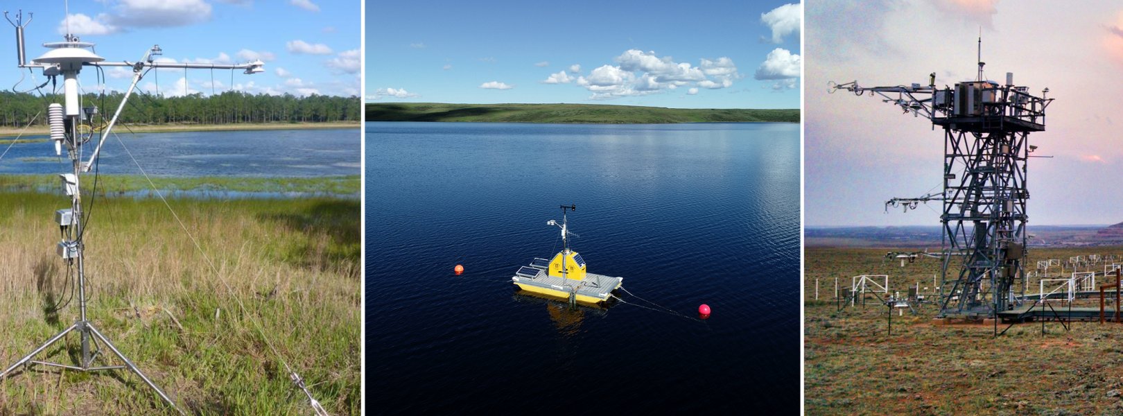
NEON monitors weather and climate conditions using various meteorological instruments deployed across terrestrial and aquatic sites. Continuous measurements capture patterns and cycles across various time periods, ranging from seconds to years. Climate and weather measurements include air temperature, humidity, precipitation, wind speed and direction, barometric pressure, and radiation. Additionally, terrestrial sites monitor phenological trends, soil heat flux, and precipitation stable isotopes, as well as atmospheric flux and isotope measurements for carbon dioxide (CO2) and water vapor (H2O) at flux towers. Meteorological infrastructure generally varies between aquatic and terrestrial sites, but often share the same sensors and data products.

Sensors

The meteorological measurements at terrestrial and aquatic sites are grouped into instrument assemblies, which are introduced in the following. Metzger et al. (2019) provide additional information.

Meteorology

The meteorology assembly measures baseline meteorological variables at frequencies between 0.1 and 1.0 Hz. These include incoming/outgoing shortwave and longwave radiation, in addition to air temperature, relative humidity, dewpoint temperature, two-dimensional wind speed and direction vertical profiles, barometric pressure, and precipitation. Further variables such as direct and diffuse radiation, throughfall precipitation, biological temperature, and photosynthetically active radiation vertical profile are also measured, and phenology imagery is taken.

Turbulent exchange

The eddy-covariance (EC) turbulent exchange assembly aims to maximize data coverage and quality through close integration of a suite of sensors and auxiliary components. The three-dimensional wind components at the tower top are measured by a sonic anemometer operating at a rate of 20 Hz. An attitude and heading reference system is attached to the sonic anemometer and includes a gyroscope, accelerometer, and magnetometer that collect data at a rate of 40 Hz. This allows rotated deployment of the sonic anemometer following the streamlines at sloped sites and makes it possible to quantify and correct residual boom and tower motions. The H2O and CO2 concentrations are measured at 20 Hz by an enclosed-path infrared gas analyzer in combination with a mass flow controller that ensures a flow rate of 12 standard liters per minute through the sampling cell (Metzger et al., 2016). Last, a validation system supplies reference gas concentrations to the infrared gas analyzer every 23.5 hours for periodic validation to quantify and correct sensor drift.

Storage exchange

The EC storage exchange assembly consists of a suite of sensors that record air temperature and CO2 and H2O concentration vertical profiles for the calculation of corresponding storage fluxes (Xu et al., 2019). Air temperature is measured at a rate of 1 Hz using triple-redundant aspirated platinum resistance thermometers at the tower top, and single aspirated platinum resistance thermometers at the remaining vertical profile levels. To measure CO2 and H2O concentrations at a rate of 1 Hz, an infrared gas analyzer is located in the instrument hut. During sampling mode, the infrared gas analyzer cycles through air samples that are drawn from each vertical profile level on the tower. The site-specific flow rate of 5–11 standard liters per minute is controlled to maintain the sample line pressure at 40%–50% of the ambient pressure to prevent condensation. During the field validation mode, reference gas concentrations are supplied to the infrared gas analyzer, similar to the EC turbulent exchange assembly.

Atmospheric composition

The atmospheric composition assembly comprises a suite of sensors that further characterize wet deposition, atmospheric isotopes, and particulate matter. Gaseous-phase stable carbon and water isotopes are measured along the flux tower vertical profile of all terrestrial sites. Wet deposition including stable isotope sampling occurs at the flux tower top across 37 terrestrial sites, which were selected to represent a range of concentrations of nitrate, ammonium, and sulfate. Particulate matter less than or equal to 10 µm in the atmosphere are monitored via PM10 sampling and continuous particle size monitoring at a transect across the Rocky Mountains consisting of six sites. Aerosol optical depth measurements at the tower top complete the atmospheric composition assembly.

Soil

The soil assembly includes five soil plots containing a suite of meteorological sensors including photosynthetically active radiation, net radiation, infrared biological temperature, relative humidity and throughfall precipitation. The plots are typically arranged along a transect within the zone of mutual representativeness (see “Flux Tower” section below) in the locally dominant (~1-km2 scale) soil type. Spacing between soil plots was determined by assessing spatial variation in soil temperature and moisture over 1 ha (Loescher et al. 2014) to maximize spatial independence, while being limited to ≤40 m spatial separation because of cost constraints. Vertical profiles of soil temperature (nine or fewer sensors per plot), moisture (eight or fewer sensors per plot), and CO2 concentration (three sensors per plot) are measured in each plot, with measurement depths based on absolute soil depth, soil horizon thicknesses, and other soil properties. Soil heat flux is measured 8 cm below the soil surface in three of the soil plots. All soil sensor measurements are made at 0.1 Hz. Additional information on soil measurements is available on the Soil Sensors webpage.

Sensor-specific details can be found in the data product documentation on the NEON data portal.

Image
Meteorological Measurements

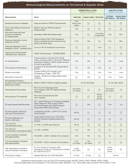
NEON Meteorological Measurements table 2021

Download Table of Meteorological Measurements (PDF)

3D Model of NEON's Meteorological Flux Tower

NEON Meteorological Flux Tower by NEONscience on Sketchfab

Stations

Types of meteorological (met) instrument infrastructure by NEON site type
Streams Rivers Lakes Terrestrial Sites
Riparian Met Station­­ Riparian Met Station Riparian Met Station Flux Tower
PAR at Water Surface Above-Water Met Station Above-Water Met Station Soil Array

Aquatic site meteorological stations measure 3m tall and are situated on or near riparian areas. Additionally, NEON deploys platform buoys with meteorological instrumentation at lake and large river sites. Due to power, space, and data storage constraints on the buoy, the configuration of sensors deployed on a buoy may be different than those in other parts of NEON. In addition to measuring PAR at water surface from the buoy on lakes and rivers, lakes and wadeable stream sites also measure PAR at water surface using in-water infrastructure, including the littoral zone in lakes. Some aquatic sites do not include precipitation measurements if a terrestrial site with a precipitation gauge is nearby.

Riparian Station

At each aquatic field site, one meteorological station sits near the aquatic body to collect weather and climate data. The aquatic meteorological station is ~3 m tall and configured with a subset of the meteorological sensors deployed on NEON’s terrestrial flux towers.

Please note these data are categorized as Terrestrial Instrument System (TIS) and not Aquatic Instrument System (AIS) data on the NEON data portal, therefore the data product numbering follows a DP1.0xxxx.001 pattern. Sensor-specific details can be found in the data product documentation on the NEON data portal.

Above-Water Station

At lake and river sites, above-water conditions can be different from riparian conditions due to the increased width of open water which results in increases in light exposure and decreased shading from riparian vegetation. Water turbulence also naturally decreases with stream size. As a result, wind speed and barometric pressure begin to dominate gas exchange (e.g. dissolved oxygen) at the water surface in larger rivers. NEON installs an above-water meteorological station at lake and river sites to collect the same data collected at riparian meteorological stations, listed above. Lake and river buoys also collect below-water PAR.

AIS data collection at CRAM
Crampton Lake (CRAM): Buoys at lake and river sites are outfitted with an above water meteorological station and surface water sensors.

The above-water meteorological station is also placed in close proximity to in situ surface water sensors and where field staff collect water samples for biogeochemical measurements. Due to power and communication limitations, buoy data are collected less frequently than riparian met station data.

  • At lake sites, the above-water meteorological station is mounted on a buoy outfitted with aquatic sensors and placed near the deepest location of the main basin. Additionally, PAR at the water surface is collected in two locations at each lake in the littoral area, which is the shallow area near the shore.
  • At river sites, the above-water, buoy-mounted met station is placed near the thalweg (lowest line in the watercourse), but outside of the main navigational channel.
  • At wadeable stream aquatic sensor set locations, NEON additionally collects PAR at the water surface.

Please note these data are categorized as Aquatic Instrument System (AIS) data on the NEON data portal, with data product numbering following the DP1.2xxxx.001 format.

DFIR at GUAN

Guanica Forest (GUAN): A Double Fence Intercomparison Reference (DFIR) collects precipitation data in a clearing at many terrestrial field sites.

Heat, water vapor, carbon dioxide, and other gases are continually exchanged between the Earth’s surface and the atmosphere. Soil, vegetation, and other living things on the Earth absorb energy from the sun and take in gases and water from the atmosphere, directly or through precipitation. They also radiate heat, send water back into the atmosphere through evapotranspiration, and release carbon and other gases back into the air through respiration. In a very real way, we can think of these fluxes as the planet breathing. To monitor this exchange at the boundary layer between living and nonliving things on the Earth and the atmosphere above, NEON collects eddy-covariance (EC) flux data alongside meteorological and atmospheric composition data at each terrestrial field site.

EC data are collected using sensors that measure temperature, moisture and gas concentrations within the turbulent air currents that move past a flux tower. By combining these data with information about the speed and direction of the air currents themselves, we can get a picture of how energy, water and gases are flowing into and out of the atmospheric boundary layer. There are also other networks collecting comparable flux data in the U.S. and internationally, including AmeriFlux, FLUXNET, ICOS and TERN. NEON represents the largest single-provider EC tower network globally, and greatly expands the number of geographic areas and types of ecosystems where these data are being collected.

Through a quantitative, footprint-based framework of mutual representativeness and exclusion, flux tower measurements are collocated with NEON’s terrestrial observation system, airborne observation platform, aquatic instrument system, and aquatic observation system (Metzger et al., 2019). This allows direct integration with and extrapolation between these types of measurements. For example, meteorological measurements combined with NEON’s soil, plant and organismal data support the ecosystem-level study of carbon dioxide, water vapor and energy fluxes, as they cycle through the atmosphere, vegetation, and the soil. Flux tower data combined with soil and airborne remote sensing data supports scaling of fluxes, soil moisture, and evapotranspiration to a continental scale. Data collected from the tower support greater understanding of ecological processes and change, such as changes in air quality and climate.

NEON terrestrial site design with the instrument and observing systems covering a wide range of scales. The terrestrial instrument system comprises a flux tower, multiple soil plots (white squares), as well as a rain gauge (DFIR, or Double Fence Intercomparison Reference). Basic meteorological, atmospheric composition, and eddy covariance (EC) flux instrumentation are located on the tower top. These capture the larger-scale synoptic forcing and surface-atmosphere exchange of the surrounding ecosystem, respectively. Additional measurements at multiple vertical levels along the tower, at the rain gauge and in the soil capture local phenomena.

Data are collected using a series of automated sensors installed on a walk-up tower. This flux tower is placed in the dominant vegetation at the field site and positioned to maximize data capture along the predominant wind direction in order to measure the representative ecosystem. The flux tower extends past the top of the vegetation canopy at each site to allow sensors mounted at the top and along the tower to capture a full vertical profile of atmospheric conditions from the top of the vegetation canopy to the ground. The number of measurement levels on a tower vary from four to eight levels depending on the ecosystem structure at each site. Horizontal poles, or boom arms, extend outward from the tower at each level. Each boom arm is 4 m long, which is twice the width of the tower to minimize the impact of flow distortion caused by the tower on wind measurements.

Each NEON flux tower comprises multiple instrument assemblies, including the EC turbulent exchange assembly, the EC storage exchange assembly, the meteorology assembly, and the atmospheric composition assembly (see Sect. “Sensors” above and Metzger et al., 2019 for additional information).

Data Products

Data products from the buoys at aquatic sites include:

  • Air temperature above water on-buoy (DP1.20046.001)
  • Barometric pressure above water on-buoy (DP1.20004.001)
  • Photosynthetically active radiation below water surface (DP1.20261.001)
  • Photosynthetically active radiation at water surface (DP1.20042.001)
  • Relative humidity above water on-buoy (DP1.20271.001)
  • Shortwave and longwave radiation above water on-buoy (net radiometer) (DP1.20032.001)
  • Wind speed and direction above water on-buoy (DP1.20059.001)

Basic meteorological data products include:

  • 2D wind speed and direction (DP1.00001.001)
  • Barometric pressure (DP1.00004.001)
  • Dust and particulate size distribution (DP1.00017.001)
  • IR biological temperature (DP1.00005.001)
  • Particulate mass (DP1.00101.001)
  • Photosynthetically active radiation (PAR) (DP1.00024.001)
  • Photosynthetically active radiation (quantum line) (DP1.00066.001)
  • Precipitation (DP1.00006.001)
  • Relative humidity (DP1.00098.001)
  • Shortwave and longwave radiation (net radiometer) (DP1.00023.001)
  • Shortwave radiation (direct and diffuse pyranometer) (DP1.00014.001)
  • Shortwave radiation (primary pyranometer) (DP1.00022.001)
  • Single aspirated air temperature (DP1.00002.001)
  • Spectral sun photometer - calibrated sky radiances (DP1.00043.001)
  • Stable isotope concentrations in precipitation (DP1.00038.001)
  • Summary weather statistics (DP4.00001.001)
  • Temporally interpolated biological temperature (DP2.00004.001)
  • Temporally interpolated PAR-line (DP2.00016.001)
  • Temporally interpolated photosynthetically active radiation (DP2.00005.001)
  • Temporally interpolated shortwave and longwave radiation (net radiometer) (DP2.00020.001)
  • Temporally interpolated triple aspirated tower temperature (DP2.00023.001)
  • Triple aspirated air temperature (DP1.00003.001)
  • Wet deposition chemical analysis (DP1.00013.001)

The eddy covariance data products are bundled into a single data product, Bundled data products - eddy covariance (DP4.00200.001). This bundle includes some basic meteorological data (as described above) as well as the following data products:

  • 3D wind attitude and motion reference (DP1.00010.001)
  • 3D wind speed, direction and sonic temperature (DP1.00007.001)
  • Atmospheric CO2 isotopes (DP1.00036.001)
  • Atmospheric H2O isotopes (DP1.00037.001)
  • Carbon dioxide flux (DP4.00067.001)
  • CO2 concentration - storage (DP1.00099.001)
  • CO2 concentration - turbulent (DP1.00034.001)
  • CO2 concentration rate of change (DP2.00008.001)
  • CO2 concentration rate of change profile (DP3.00009.001)
  • Flux footprint characteristics (DP4.00201.001)
  • H2O concentration - storage (DP1.00100.001)
  • H2O concentration - turbulent (DP1.00035.001)
  • H2O concentration rate of change (DP2.00009.001)
  • H2O concentration rate of change profile (DP3.00010.001)
  • Latent heat flux (DP4.00137.001)
  • Momentum flux (DP4.00007.001)
  • Sensible heat flux (DP4.00002.001)
  • Temperature rate of change (DP2.00024.001)
  • Temperature rate of change profile (DP3.00008.001)

In addition to several basic met products, the soil plot measurements include the Soil heat flux plate data product.

Related Publications

  • Csavina, J., Roberti, J. A., Taylor, J. R., and Loescher, H. W.: Traceable measurements and calibration: A primer on uncertainty analysis, Ecosphere, 8, e01683, doi:10.1002/ecs2.1683, 2017.
  • Loescher, H., Ayres, E., Duffy, P., Luo, H., and Brunke, M.: Spatial variation in soil properties among North American ecosystems and guidelines for sampling designs, PLoS One, 9, e83216, doi:10.1371/journal.pone.0083216, 2014.
  • Metzger, S., Agarwal, D., Biraud, S., Durden, D., Luo, H., Papale, D., Pastorello, G., Sturtevant, C., and Torn, M. S.: White Paper: Globally interoperable eddy-covariance data products through affiliating NEON sites with AmeriFlux and FLUXNET, National Ecological Observatory Network, Boulder, CO, U.S.A., 12 pp., doi:10.13140/RG.2.2.29566.95040/2, 2016.
  • Metzger, S., Durden, D., Sturtevant, C., Luo, H., Pingintha-Durden, N., Sachs, T., Serafimovich, A., Hartmann, J., Li, J., Xu, K., and Desai, A. R.: eddy4R 0.2.0: a DevOps model for community-extensible processing and analysis of eddy-covariance data based on R, Git, Docker, and HDF5, Geosci. Model Dev., 10, 3189-3206, doi:10.5194/gmd-10-3189-2017, 2017.
  • Metzger, S., Ayres, E., Durden, D., Florian, C., Lee, R., Lunch, C., Luo, H., Pingintha-Durden, N., Roberti, J. A., SanClements, M., Sturtevant, C., Xu, K., and Zulueta, R. C.: From NEON field sites to data portal: a community resource for surface–atmosphere research comes online, Bull. Am. Meteorol. Soc., 100, 2305-2325, doi:10.1175/bams-d-17-0307.1, 2019.
  • SanClements, M., Lee, R. H., Ayres, E. D., Goodman, K., Jones, M., Durden, D., Thibault, K., Zulueta, R., Roberti, J., Lunch, C., and Gallo, A.: Collaborating with NEON, BioScience, 70, 107-107, doi:10.1093/biosci/biaa005, 2020.
  • Smith, D. E., Metzger, S., and Taylor, J. R.: A transparent and transferable framework for tracking quality information in large datasets, PLoS One, 9, e112249, doi:10.1371/journal.pone.0112249, 2014.
  • Taylor, J. R., and Loescher, H. L.: Automated quality control methods for sensor data: A novel observatory approach, Biogeosciences, 10, 4957-4971, doi:10.5194/bg-10-4957-2013, 2013.
  • Xu, K., Metzger, S., and Desai, A. R.: Surface-atmosphere exchange in a box: Space-time resolved storage and net vertical fluxes from tower-based eddy covariance, Agric. For. Meteorol., 255, 81-91, doi:10.1016/j.agrformet.2017.10.011, 2018.
Related Content
Atmospheric Stable Isotope TWG
Surface Atmosphere Exchange TWG
NEON Logo

Follow Us:

Join Our Newsletter

Get updates on events, opportunities, and how NEON is being used today.

Subscribe Now

Footer

  • My Account
  • About Us
  • Newsroom
  • Contact Us
  • Terms & Conditions
  • Careers

Copyright © Battelle, 2019-2020

The National Ecological Observatory Network is a major facility fully funded by the National Science Foundation.

Any opinions, findings and conclusions or recommendations expressed in this material do not necessarily reflect the views of the National Science Foundation.