10 Years of Excellence – Meet More of NEON's Airborne Team!
August 30, 2023

In mid-2019, the National Ecological Observatory Network officially came fully online with the completion of our last site in Hawaii (PUUM). But some parts of the Observatory have been in operation for longer, collecting data and samples that are available to our community. This year, 2023 marks the 10th anniversary of operations for NEON's Airborne Observation Platform (AOP)!
NEON's AOP has generated massive amounts of data, which have been used in many studies and publications over the years. The effort that goes into making the flight schedules, calibrating the instrument payloads, making sure everything goes smoothly, and collecting high-quality data requires a dedicated team.
Last year, we introduced you to some of NEON's Airborne Sensor Operators (ASOs), who have the opportunity to travel to our many Domains with the AOP payloads. But our AOP team consists of many moving parts and a myriad of brilliant staff. Meet some more of the team here – Bridget Hass, Brendan Roberts, and Nick Marusich!
Brendan Roberts
What is your background and how did you get interested in remote sensing data and working for the AOP?
I have a B.S. and an M.S. both in Aerospace Engineering, with a focus in Bioastronautics from the University of Colorado, Boulder. Graduate school studies sent me to Antarctica, where I trained on lidar and remote sensing, running a ground-based resonant fluorescence lidar that measured wind and temperature up to the Lower Thermosphere. This lidar experience was amazing, and it took me to a far-flung destination that most people never see. Staying on a path that led to adventure and working with lasers was a major driver to joining NEON AOP.
What is the most interesting part about your role in AOP? What is the most challenging part?
Learning about all the details that go into spectrometer data collection. I'm still learning more every day. The most challenging is remotely troubleshooting sensors and systems. The pressure really kicks in because every failure needs to be fixed as quickly as possible knowing that missing a day of flight is very expensive and can mean missing a window to even collect data in a Domain. Sometimes it feels a bit like the engineering troubleshooting scene in Apollo 13.
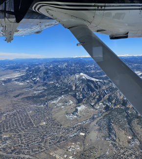
Photo of the Boulder Flatirons during a calibration flight in Colorado. Photo credit: Brendan Roberts.
Which Domain or field site is your favorite to visit? Why?
D08 – Ozarks Complex. Domain 08 is an interesting cross section of people and places. Visiting DELA [add name] and chatting with Red (the site host who lives on site) and having his neighbor dare you to eat an unknown extremely hot pepper mid-morning is a treat you will be hard pressed to find in another Domain.
What's the most exciting thing you've seen while traveling the country?
I'd have to say seeing the midnight sun in Delta Junction in Alaska, seeing the aurora borealis on drives to the towers at Healy and Toolik, and being on the lookout for bears at Yellowstone.
What's the most frequently asked question you get when talking to people about your job?
Do you think climate change is real, man-made, and a looming catastrophe? I always answer the same: we calibrated our CO2 sensors at or a little below 380 ppm when I started at NEON years ago. Today, we are at a 420 ppm calibration level. That increase in ambient atmospheric CO2 is not sustainable long term.
Bridget Hass
What is your background and how did you get interested in remote sensing data and working for the AOP?
My background is in Earth Science. I studied Marine Geophysics for my Master's degree, and my thesis focused on subduction zone earthquakes along the west coast of the Americas. After my undergrad degree, and as part of graduate school, I worked on research ships as a geophysical technician and in various roles. During that time I got hands-on experience operating geophysical equipment (including seismic receivers, magnetometers, and echosounders) to map the ocean floor. I also worked with the geophysical datasets; to do that I had to learn some coding languages (mainly MATLAB). This background translated well to the field of remote sensing, where we are using similar instruments, but the sensing platform is a plane flying above the Earth instead of a ship on the surface of the sea. While I didn't have any formal training in remote sensing, it is similar to geophysics in many ways, and it's been fun to learn more about ecology too along the way!
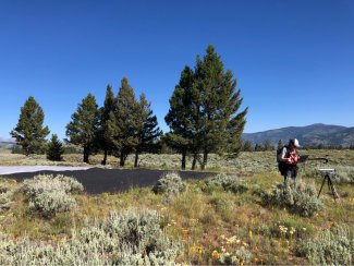
Bridget collecting handheld spectrometer data for a radiometric validation flight at Yellowstone.
What is the most interesting part about your role in AOP? What is the most challenging part?
I like problem-solving. I would say the most interesting part of my job is probably also the challenging part... because we're a small team, we all wear many hats. I like that I get to be involved with all parts of the process – from collecting field data to processing and improving our algorithms – and that I get to create and share tools for scientists to work with our data. Sometimes I get pulled in a lot of different directions, but that keeps it interesting!
Which Domain or field site is your favorite to visit? Why?
I have only visited a small portion of our sites, but as I'm from Oregon, I'm a little more partial to the sites in the western U.S. The Healy site in Alaska, right by Denali National Park, is incredible, and Wind River Experimental Forest in D16 is home to an incredible old-growth forest, which reminds me of home.
What's the most exciting thing you've seen while traveling the country?
Hmm... this is tough... there are so many exciting things! Probably the most exhilarating was almost running into a grizzly bear on a hike in Alaska. More locally (in Colorado, right outside of Boulder) we had to work around a herd of elk where we were planning to set up our validation equipment. It's been fun to meet the NEON field crews at various Domains and to learn some of the botany and local knowledge when we get to team up for spectral sampling of the vegetation. Each site is unique. It's also fun to meet scientists at workshops and see all the ways NEON data are used for research, and to see how much the remote sensing field is growing.
What's the most frequently asked question you get when talking to people about your job?
It's sometimes a little tricky to explain what I do without going into a lot of detail, as it's not a super common thing. So I often simplify my job to "aerial mapping." Then people ask, what we are mapping and why. I'm still working on my elevator pitch...
What's your role in AOP? Has it changed since you've joined?
I am now a Data Scientist, and although that doesn't fully capture my role, I do wrangle data a lot! I started out as a processing technician, working mainly on generating the lidar data products. My role quickly evolved, however; I moved on to being a researcher on the AOP team and then more recently became a data scientist. I have helped automate our remote sensing processing pipeline, and have worked quite a bit on the data management side of things. I also now split my time between the AOP and Data Skills teams and am more involved with creating resources (online tutorials, etc.) and teaching (e.g., webinars, workshops) for the external science community to use and work with AOP and other NEON data.
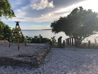
GPS station set up at the Guanica site (GUAN) in Puerto Rico to validate the vertical accuracy of the lidar data. Photo credit: Bridget Hass.
Can you describe one of your typical workdays?
My days can vary quite a bit depending on the season and what's needed. I have field work days, data processing days, coding days, days where I'm teaching live coding. Lately I have been working on a project to get some of the AOP datasets into Google Earth Engine and writing scripts for others to work with NEON data in Earth Engine. It really varies - every day is different.
Nick Marusich
What is your background, and how did you get interested in remote sensing data and working for the AOP?
My background is in flight operations; I have a B.S. in Mechanical Engineering and 23 years as a flight officer aboard aircraft carriers before coming to NEON. I also hold an M.A. in National Security Studies from the Royal Military College of Canada and an M.A. in Social Sciences from Haifa University in Israel. The mission and vision of this program drew me to working with NEON.
What is the most interesting part about your role in AOP?
I enjoy getting to work with a vast array of technical experts. My work touches almost all parts of NEON: Domain field staff, instrumentation systems, engineering, accounting, procurement, administration, and leadership.
What's your role in AOP? Has it changed since you've joined AOP? How?
I lead the flight operations team. At first, my job was solely focused on NEON AOP flight data collections. Since then, my position has taken broader roles of remote sensing at NEON and within Battelle. With developing Unmanned Aerial Systems (UAS) operations and capabilities, the flight operations team has supported other projects, such as the Battelle Arctic Research Logistics Support program, UAS data collections for the Great Lakes remediation assessments, EPA remediation projects, and the precision agriculture team to name a few.
Can you describe one of your typical workdays?
I normally check how data collections are going; I review daily flight reports, area weather, and Domain data collection status. If I am flying, I jump into reviewing weather to determine if it is acceptable to fly. If it is, we coordinate with the crew to set the day's flight location and schedule. Flights last around 4 hours. Following flights, we start the flight data downloads, quality checks, and post flight paperwork and reports. Once everything is solid, we set the crew and anticipated plan for the next day. If I am not flying, which is quite often, I tackle tasks that normally pop up: supporting the flight operations and AOP team, facility management, administrative work, budgeting, or Assignable Asset projects and proposals.
What's the most frequently asked question you get when talking to people about your job?
How do you go to the bathroom? People are amazed at the technology in the aircraft, but they tend to eventually get past that and look at what they can relate to, which tends to be normal daily items. The Twin Otter is not like a commercial airliner with creature comforts or expected services. We have ways to go when in flight but the best measure is to prepare ahead of time. I’ll just leave it at that.
 Celebrating the 10th Anniversary of AOP
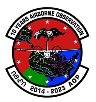
2023 AOP flight patch - designed by Nick Marusich
This is the 10th year of flight data collection by the AOP. To recognize the milestone, this year's flight patch takes elements from previous designs. The background uses red, green, and blue that started with the first design in 2014 and is portioned based on the angles from the 2015 design. Most designs include the aircraft, the continental U.S., and Alaska. The aircraft design is from a 'heads' aspect from 2016. The geographic areas include topographical lines taken from the 2021 design. The twin otters are from the Twin Otter International, Limited tail logo (the type of aircraft used by the NEON AOP). 10 stars border the design, representing the 10years in operation.
