Getting to Know the NEON Domains: Ozarks Complex
June 3, 2020
View the Ozarks Complex Domain storymap here!
This blog series explores each of the 20 NEON ecoclimate Domains and the field sites within them.
The Ozarks Complex (Domain 08) takes its name from the Ozark Mountains and Plateau, but this diverse Domain contains more than just mountains. Stretching across the southern U.S. from eastern Oklahoma and Texas to western Georgia, D08 supports a variety of ecosystems ranging from upland hardwood forests to coastal floodplains. The NEON program field sites in Alabama provide a window into watershed dynamics in the southeastern U.S.
Defining the Ozarks Complex Domain
The Ozarks Complex encompasses 609, 928 km2 (235,494 square miles) that includes all of Arkansas as well as large portions of Missouri, Louisiana, Mississippi, Alabama, and Tennessee; the eastern edges of Oklahoma and Texas; and the western edge of Georgia. All six NEON field sites are located in Alabama.
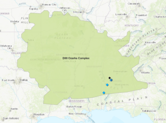
Map of Domain 08, the Ozarks Complex
The Ozarks, which give the Domain its name, is a highland region in Arkansas, Missouri, and Oklahoma that includes two mountain ranges, two large plateaus, and regions of gently rolling hills. The area is characterized by temperate hardwood and mixed forests dominated by oak, hickory, shortleaf pine, and eastern red cedar. Abundant streams, rivers, and lakes are found throughout the landscape. Water moving through the limestone and dolomite bedrock has created a karst topography with numerous caves and sinkholes. In some parts of the Ozarks, rocky hilltops support more desert-like ecosystems with grasses and cacti.
In Alabama, where the NEON field sites are located, the landscape ranges from the hills and highlands of the Appalachian and Piedmont Plateaus to the lowlands of the Gulf Coastal Plains. It is one of the most biologically diverse regions in the U.S., with many distinct ecosystems including forests and woodlands, glades and prairies, swamps and wetlands, and riparian and marine ecosystems. Similar diversity can be found in the neighboring states that make up the remainder of D08.
This biological diversity is a result of a warm, wet climate and a rich geologic past that has created regions with distinct topographic and geologic characteristics. Precipitation varies across the Domain, but Louisiana, Mississippi, and Alabama rank 2nd, 3rd, and 4th in the U.S. for annual precipitation, behind only Hawaii. Warm, moist waters from the Gulf Coast contribute to this rainfall. Most of the Domain also enjoys warm temperatures, plenty of sunlight and a relatively long growing season. As a result, this is one of the most biologically productive areas in the U.S.
The Mississippi River divides the Domain as it makes its way down to the Gulf of Mexico. A complicated network of rivers and streams running into the Mississippi or directly into the Gulf creates lush riparian and wetland systems throughout the region.
Domain 08 has three colocated sets of terrestrial and aquatic field sites. These sites are situated along the same watershed system, creating a unique opportunity to study hydrology, nutrient transport, and biogeochemical cycling through the watershed.
- Talladega National Forest (TALL) and Mayfield Creek (MAYF)
- Dead Lake (DELA) and Black Warrior River Near Dead Lake (BLWA)
- Lenoir Landing (LENO) and Lower Tombigbee River at Choctaw Refuge (TOMB)
Talladega National Forest and Mayfield Creek
TALL and MAYF are the northernmost sites in D08, and the most pristine. They are located in the Talladega National Forest in central Alabama, where the southern foothills of the Appalachia Mountains meet the coastal plains. Due to the unique topography and transition zone location, TALL is one of NEON's most biodiverse sites. Upland areas are dominated by longleaf pine while bottomlands feature mixed hardwoods. The area was extensively logged prior to its designation as a national forest in 1943. Mayfield Creek runs into the Black Warrior River to the south.
Dead Lake and Black Warrior River Near Dead Lake
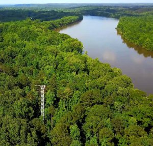
DELA and BLWA are located in central Alabama, near the confluence of the Black Warrior and Tombigbee Rivers. They are roughly 75 miles south and west of the TALL and MAYF sites. The sites are just outside the city of Demopolis (population 7500). Human activity—including extensive logging, agriculture, coal mining, and industry—has had a significant impact on the landscape. The field sites sit in a natural floodplain with wetlands and young forest with a mixture of cypress, hardwoods, and introduced pines. The Black Warrior River flows 178 miles from the Appalachian Highlands to the Tombigbee River.
Lenoir Landing and Lower Tombigbee River at Choctaw Refuge
LENO and TOMB are the southernmost sites in D08, downstream of both TALL/MAYF and DELA/BLWA. The sites are found in southwestern Alabama along the Tombigbee River, about 90 miles north of Mobile and the Gulf of Mexico. The land is part of the Chocktaw Wildlife Refuge, a 4,218-acre migratory bird refuge featuring bottomland hardwood forests, wetlands, swamps, and several lakes and creeks. The Tombigbee River is a major waterway that merges with the Mobile River before emptying into the Gulf of Mexico.
Studying Watershed Systems
The three pairs of sites in the Ozarks Complex are all part of the Tombigbee River watershed; Mayfield Creek flows into the Black Warrior River, which then joins the Tombigbee as waters flow south to the Gulf. This is the only Domain in the NEON program with multiple sites connected by a single waterway. It is also the only Domain that has sites featuring big rivers with large floodplain and delta areas.
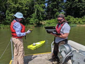
Field technicians doing arcboat tests for bathymetry mapping at the BLWA aquatic site
This provides a unique opportunity to study how nutrients, pollutants, and biota move through watershed systems in both aquatic and terrestrial environments. The data could provide important insights into watershed hydrology and biogeochemistry, as well as how watershed systems respond to human impacts or natural disturbances. Some researchers are already looking into the use of NEON data to model nutrient transport through the Tombigbee River watershed. Looking at water chemistry and quality data at each of the sites could also help answer questions about where industrial pollutants and agricultural runoff are entering the waterways in Alabama. Colocating the aquatic and terrestrial sites in each area enables analysis of biogeochemical cycling between aquatic and terrestrial systems along the watershed.
The NEON program will provide important data to track the presence and impact of invasive species in the southeastern U.S. Invasive plant species are a particular concern at all of the terrestrial field sites. Chinese privet (Ligustrum sinense), Japanese stiltgrass (Microstegium vimineum), kudzu (genus Pueraria), and other non-native species, many originally introduced for ornamental use, are crowding out native species throughout Alabama and other parts of D08. Their spread has a cascade effect on the rest of the ecosystem, changing the structure and composition of forests and grasslands and destroying habitat for native birds, insects, and small mammal species. NEON data will allow researchers to track the spread of invasive plant species and look at how their presence impacts animal, insect, and microbial communities.
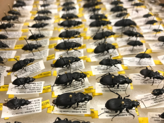
Archive of tagged and identified beetles
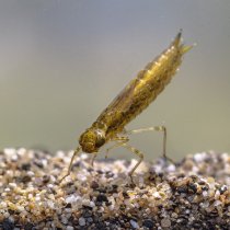
Invasive insects are another concern in the region, especially the emerald ash borer (Agrilus planipennis) and other species that damage native hardwood trees. Climate change has enabled many species of insects to expand their range and population size, moving into new areas or increasing their impact on other species. NEON data will help researchers track ground beetle populations as well as ticks and mosquitos and the pathogens they carry.
Alabama and neighboring states are expected to get hotter over the next decades. The region is also likely to see both increased flooding and extended periods of drought. Climate change may bring more frequent and severe tropical storms and hurricanes from the Gulf of Mexico, with impacts that extend far inland. The NEON program will provide invaluable data to help scientists monitor these changes and update climate models.