NSF NEON, Operated by Battelle

Main navigation

  • About Us
    • Overview
      • Spatial and Temporal Design
      • History
    • Vision and Management
    • Advisory Groups
      • Science, Technology & Education Advisory Committee
      • Technical Working Groups (TWGs)
    • FAQ
    • Contact Us
      • Contact NEON Biorepository
      • Field Offices
    • User Accounts
    • Staff
    • Code of Conduct

    About Us

  • Data & Samples
    • Data Portal
      • Explore Data Products
      • Data Availability Charts
      • Spatial Data & Maps
      • Document Library
      • API & GraphQL
      • Prototype Data
      • External Lab Data Ingest (restricted)
    • Data Themes
      • Biogeochemistry
      • Ecohydrology
      • Land Cover and Processes
      • Organisms, Populations, and Communities
    • Samples & Specimens
      • Discover and Use NEON Samples
        • Sample Types
        • Sample Repositories
        • Sample Explorer
        • Megapit and Distributed Initial Characterization Soil Archives
      • Sample Processing
      • Sample Quality
      • Taxonomic Lists
    • Collection Methods
      • Protocols & Standardized Methods
      • Airborne Remote Sensing
        • Flight Box Design
        • Flight Schedules and Coverage
        • Daily Flight Reports
          • AOP Flight Report Sign Up
        • Camera
        • Imaging Spectrometer
        • Lidar
      • Automated Instruments
        • Site Level Sampling Design
        • Sensor Collection Frequency
        • Instrumented Collection Types
          • Meteorology
          • Phenocams
          • Soil Sensors
          • Ground Water
          • Surface Water
      • Observational Sampling
        • Site Level Sampling Design
        • Sampling Schedules
        • Observation Types
          • Aquatic Organisms
            • Aquatic Microbes
            • Fish
            • Macroinvertebrates & Zooplankton
            • Periphyton, Phytoplankton, and Aquatic Plants
          • Terrestrial Organisms
            • Birds
            • Ground Beetles
            • Mosquitoes
            • Small Mammals
            • Soil Microbes
            • Terrestrial Plants
            • Ticks
          • Hydrology & Geomorphology
            • Discharge
            • Geomorphology
          • Biogeochemistry
          • DNA Sequences
          • Pathogens
          • Sediments
          • Soils
            • Soil Descriptions
        • Optimizing the Observational Sampling Designs
    • Data Notifications
    • Data Guidelines and Policies
      • Acknowledging and Citing NEON
      • Publishing Research Outputs
      • Usage Policies
    • Data Management
      • Data Availability
      • Data Formats and Conventions
      • Data Processing
      • Data Quality
      • Data Product Bundles
      • Data Product Revisions and Releases
        • Release 2021
        • Release 2022
        • Release 2023
        • Release 2024
        • Release-2025
      • NEON and Google
      • Externally Hosted Data

    Data & Samples

  • Field Sites
    • About Field Sites and Domains
    • Explore Field Sites
    • Site Management Data Product

    Field Sites

  • Impact
    • Observatory Blog
    • Case Studies
    • Papers & Publications
    • Newsroom
      • NEON in the News
      • Newsletter Archive
      • Newsletter Sign Up

    Impact

  • Resources
    • Getting Started with NEON Data & Resources
    • Documents and Communication Resources
      • Papers & Publications
      • Document Library
      • Outreach Materials
    • Code Hub
      • Code Resources Guidelines
      • Code Resources Submission
      • NEON's GitHub Organization Homepage
    • Learning Hub
      • Science Videos
      • Tutorials
      • Workshops & Courses
      • Teaching Modules
    • Research Support Services
      • Field Site Coordination
      • Letters of Support
      • Mobile Deployment Platforms
      • Permits and Permissions
      • AOP Flight Campaigns
      • Research Support FAQs
      • Research Support Projects
    • Funding Opportunities

    Resources

  • Get Involved
    • Advisory Groups
      • Science, Technology & Education Advisory Committee
      • Technical Working Groups
    • Upcoming Events
    • NEON Ambassador Program
      • Exploring NEON-Derived Data Products Workshop Series
    • Research and Collaborations
      • Environmental Data Science Innovation and Inclusion Lab
      • Collaboration with DOE BER User Facilities and Programs
      • EFI-NEON Ecological Forecasting Challenge
      • NEON Great Lakes User Group
      • NEON Science Summit
      • NCAR-NEON-Community Collaborations
        • NCAR-NEON Community Steering Committee
    • Community Engagement
      • How Community Feedback Impacts NEON Operations
    • Science Seminars and Data Skills Webinars
      • Past Years
    • Work Opportunities
      • Careers
      • Seasonal Fieldwork
      • Internships
        • Intern Alumni
    • Partners

    Get Involved

  • My Account
  • Search

Search

Field Sites

  • About Field Sites and Domains
  • Explore Field Sites
  • Site Management Data Product

Breadcrumb

  1. Field Sites
  2. Smithsonian Conservation Biology Institute NEON

Field Site

Smithsonian Conservation Biology Institute NEON / SCBI

brown square white mountain icon

Core Terrestrial, VA, D02: Mid-Atlantic

Flux tower at the SCBI field site

About Field Sites

Smithsonian Conservation Biology Institute (SCBI) is a terrestrial field site located on the foothills of the Blue Ridge Mountains in Front Royal, Virginia. The 12 km2 (2966 acre) NEON field site is located within and hosted by the Smithsonian Conservation Biology Institute, a research and education institution run by the Smithsonian Institution. The site is dominated by mature and secondary hardwood forest. This site is located within NEON's Mid-Atlantic Domain (D02), a densely populated region bounded by the Atlantic Ocean on the east and stretching down the Eastern Seaboard from southern New Jersey to northern Georgia. The Mid-Atlantic Domain includes two other terrestrial sites and two aquatic sites. SCBI is colocated with the POSE aquatic site. [1] [2]

Climate

The climate here is temperate and humid, with annual mean temperatures of 11.6°C (53°F). The coldest month of the year is January with an average temperature of -1.6°C (29.12°F), while July is the warmest month with an average temperature of 23.8°C (74.84°F). On average, this location gets a total of 1125 mm (44 in.) of precipitation annually. September the wettest month with an average monthly precipitation of 160 mm (6.3 in.) and December is the driest with only 50.8 mm (2 in.) of precipitation. [4] [8]

Geology

SCBI is located on the Catoctin Formation. The parent materials at the site are residuum, colluvium and local alluvium derived from Cambrian age crystalline rocks, including meta-basalt, greenstone, and gabbro. [2]

Soils

The main soil series found at SCBI include Myersville, Hawksbill, Lew, Montalto, Catoctin, and Thurmont soils. From soils sampled at the SCBI site, the most abundant soil series was found to be Myersville soil on residual ridgetops and side slopes. The second most abundant soil series was found to be Lew soil on colluvial side slopes. [2]

Hydrology

SCBI is located within the Potomac-Shenandoah watershed. Major tributaries of this watershed include the Potomac River, South Fork Shenandoah, and North Fork Shenandoah tributaries. The Potomac-Shenandoah watershed drains into the Chesapeake Bay. [3]

Vegetation

The Smithsonian Conservation Biology Institute is primarily dominated by deciduous hardwood forests. These consist of both mature (>100 years) forest and young (<40 years) secondary forest. The mature forests are primarily oak (Quercus spp.), hickory (Carya spp.), ash (Fraxinus spp.), and tulip poplar (Liriodendron tulipifera) while the young forests consist primarily of white ash (Fraxinus americana), black locust (Robinia pseudoacacia), and dogwood (Cornus spp.). [1]

Fauna

Fauna native to the mid-Atlantic region that encompasses SCBI include white-tailed deer (Odocoileus virginianus), coyote (Canis latrans), red fox (Vulpes vulpes), raccoon (Procyon lotor), and black bear (Ursus americanus). [5]

Past Land Management and Use

The land and facilities that now make up the Smithsonian Conservation Biology Institute have a fascinating history that goes back more than a century. In 1911, the U.S. government purchased 42 farms in the Front Royal, Virginia area. The resulting tract of land was 4200 acres of mostly farmland and pasture. A remount station was established on this land to breed and train horses and mules for the U.S. Army. With the onset of World War II, the center was converted into a K-9 training facility and housed 600 Italian and German prisoners of war. After the war ended, the center was acquired by the U.S. Department of Agriculture and used as a Beef Cattle Research Station in partnership with Virginia Polytechnic Institute and State University. During this time, the U.S. State Department used some of the center’s facilities to establish an Emergency Relocation site and communications base in case of national emergencies. By 1973, both the USDA research station and the site’s State Department facilities had shut down. The Smithsonian officially acquired the site in 1975 and converted it into a Smithsonian National Zoo captive breeding center. The site was named the Conservation and Research Center and, since its establishment, has expanded its mission to include a large variety of conservation activities and research. The center was renamed the Smithsonian Conservation Biology Institute and, today, continues its important work safeguarding endangered species and natural places throughout the world. [6]

Current Land Management and Use

The Smithsonian Conservation Biology Institute (SCBI) is a research and educational institution associated with the Smithsonian Institution’s National Zoo. The Smithsonian Conservation Biology Institute, previously called the Conservation and Research Center, has been based in Front Royal, Virginia since 1974. The facility is involved in a variety of conservation projects both locally and abroad. Among other missions, SCBI is working to safeguard endangered species through captive breeding programs, research to support understanding of ecosystem functions and changes, and training for current and future conservation professionals. The Smithsonian Conservation Biology Institute currently hosts NEON’s Domain 02 base of operations, with Domain 02’s labs and offices located on-site at the Front Royal facility. [6] [7]

NEON Site Establishment

Plot establishment for NEON’s SCBI site was completed in November 2015. The site’s Initial Operations Capability/Capacity Review (IOCR), or when operations were officially approved to start, was November 2014 for terrestrial sampling. The site’s IOCR for tower operations was July 2016.

Additional Resources

[1] Terrestrial Observation System (TOS) Site Characterization Report: Domain 02. (NEON Doc. #: NEON.DOC.003886)

[2] Sattler, A. (2016) NEON Site-Level Plot Summary Smithsonian Conservation Biology Institute (SCBI). Retrieved from https://data.neonscience.org/documents/10179/2361410/SCBI_Soil_SiteSumm….

[3] Virginia Department of Conservation and Recreation. (n.d.). Virginia’s Major Watersheds. Retrieved from https://www.dcr.virginia.gov/soil-and-water/wsheds.

[4] Nelms, D. L., & Moberg, R. M. (2010). Preliminary Assessment of the Hydrogeology and Groundwater Availability in the Metamorphic and Siliciclastic Fractured-Rock Aquifer Systems of Warren County, Virginia. Retrieved from https://pubs.usgs.gov/sir/2010/5190/pdf/sir2010-5190.pdf.

[5] National Park Service. (n.d.) Animals. Retrieved from https://www.nps.gov/shen/learn/nature/animals.htm

[6] Smithsonian’s National Zoo. (2016, July 29). History of the SCBI Complex. Retrieved from https://nationalzoo.si.edu/conservation/history-scbi-complex.

[7] Smithsonian’s National Zoo. (2016, July 22). About SCBI. Retrieved from https://nationalzoo.si.edu/conservation/about-scbi.

[8] PRISM Climate Group, Oregon State University, http://prism.oregonstate.edu, created 4 Feb 2004.

Field Site Information

Latitude/Longitude

38.892925, -78.139494

Geodetic Datum

WGS84

Location

Warren County
VA, US

Elevation

Mean: 352m
Minimum: 251m
Maximum: 571m

Mean Annual Temperature

11.6°C

Dominant Wind Direction

SSE

Mean Canopy Height

35.0m

Dominant NLCD Classes

Deciduous Forest, Evergreen Forest, Pasture/Hay

Colocated Site(s)

Posey Creek NEON

Colocated Research

ForestGEO
Critical Zone Exploration Network
Ameriflux

Field Operations Office

1500 Remount Road
MRC 5560, Bldg 90
Front Royal, VA 22630

Research Access

Non-NEON research activities are allowed in this area. Researchers must obtain their own permits with the site host(s).

Request Access

Observation Types

Remote Sensing

Remote sensing surveys of this field site collect lidar, spectrometer and high-resolution RGB camera data.

Meteorological Measurements

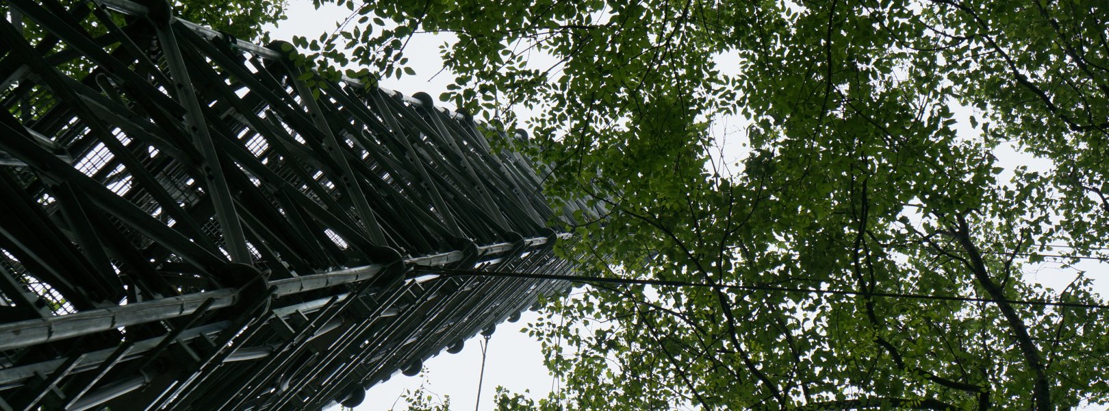
This site has a flux/meteorological tower that is 52 m (171 ft) tall with six measurement levels. The tower top extends above the vegetation canopy to allow sensors mounted at the top and along the tower to capture the full profile of atmospheric conditions from the top of the vegetation canopy to the ground. The tower collects physical and chemical properties of atmosphere-related processes, such as humidity, wind, and net ecosystem gas exchange. Precipitation data are collected by a tipping bucket at the top of the tower, a Double Fence Intercomparison Reference (DFIR) near the tower, and a series of throughfalls located in the soil array.

Phenocams

One phenocam is attached to the top and the bottom of the tower. Here we show the images from the most recent hour. The full collection of images can be viewed on the Phenocam Gallery - click on either of the images below.

Tower top

NEON.D02.SCBI.DP1.10033

Tower bottom

NEON.D02.SCBI.DP1.10042

Soil Sensor Measurements

This site has five soil plots placed in an array within the airshed of the flux tower. Photosynthetically Active Radiation (PAR) at soil surface, soil heat flux, solar radiation, and throughfall are measured at the soil surface in each soil plot. Soil moisture, soil temperature, and CO2 concentration are measured at multiple depths in each soil plot.

Observational Sampling

At terrestrial sites, field ecologists observe birds and plants, and sample ground beetles, mosquitoes, small mammals, soil microbes, and ticks. Lab analyses are carried out to provide further data on DNA sequences, pathogens, soils, sediments, and biogeochemistry. Learn more about terrestrial observations or explore this site's data products.


Field Site Data

Site

Site Host

Smithsonian Institution

Site Access Allowed

Yes

Site URL

https://www.si.edu/unit/conservation-biology-institute

Site Access Details

Significant portions of the site are off-limits or have restricted access due to captive animal activities. Annual hunting activities may render this area completely inaccessible for short periods of time (1 or 2 days) over the course of the season. Most research activities require approval from a land-use committee; and stays longer than a month may require the researcher to apply for contractor credentials and submit to a background check.

Operations Office

NEON Field Operations Office

Domain 02 Support Facility

NEON Field Operations Address

1500 Remount Road
MRC 5560, Bldg 90
Front Royal, VA 22630

NEON Field Operations Phone

540.692.1919

Location

Latitude

38.892925

Longitude

-78.139494

Geodetic Datum

WGS84

UTM Northing

4308784.08m

UTM Easting

748090.65m

UTM Zone

17N

County

Warren

State

VA

Country

US

Mean Elevation

352m

Minimum Elevation

251m

Maximum Elevation

571m

Climate

Mean Annual Temperature

11.6°C

Mean Annual Precipitation

1126mm

Dominant Wind Direction

SSE

Vegetation

Mean Canopy Height

35.0m

Dominant NLCD Classes

Deciduous Forest, Evergreen Forest, Pasture/Hay

Average number of green days

245

Average first greenness increase date

85 DOY

Average peak green date

150 DOY

Average first greenness decrease date

220 DOY

Average minimum greenness date

320 DOY

Tower

Tower Height

52m

Number of Tower Levels

6

Soils

Megapit Soil Family

Loamy-skeletal - mixed - active - mesic Ultic Hapludalfs

Soil Subgroup

Ultic Hapludalfs


Gallery

  • Photos
  • Videos

No Photos

No Video


Related Field Sites

Other Domain D02 Field Sites

brown circle white drop icon Blandy Experimental Farm NEON
Gradient Terrestrial
blue circle white drop icon Lewis Run NEON
Gradient Aquatic
blue square white drop icon Posey Creek NEON
Core Aquatic
brown circle white drop icon Smithsonian Environmental Research Center NEON
Gradient Terrestrial

Other Field Sites in VA

brown circle white drop icon Blandy Experimental Farm NEON
Gradient Terrestrial
blue circle white drop icon Lewis Run NEON
Gradient Aquatic
brown circle white drop icon Mountain Lake Biological Station NEON
Gradient Terrestrial
blue square white drop icon Posey Creek NEON
Core Aquatic
NSF NEON, Operated by Battelle

Follow Us:

Join Our Newsletter

Get updates on events, opportunities, and how NEON is being used today.

Subscribe Now

Footer

  • About Us
  • Newsroom
  • Contact Us
  • Terms & Conditions
  • Careers
  • Code of Conduct

Copyright © Battelle, 2025

The National Ecological Observatory Network is a major facility fully funded by the U.S. National Science Foundation.

Any opinions, findings and conclusions or recommendations expressed in this material do not necessarily reflect the views of the U.S. National Science Foundation.