NSF NEON, Operated by Battelle

Main navigation

  • About Us
    • Overview
      • Spatial and Temporal Design
      • History
    • Vision and Management
    • Advisory Groups
      • Science, Technology & Education Advisory Committee
      • Technical Working Groups (TWGs)
    • FAQ
    • Contact Us
      • Contact NEON Biorepository
      • Field Offices
    • User Accounts
    • Staff
    • Code of Conduct

    About Us

  • Data & Samples
    • Data Portal
      • Explore Data Products
      • Data Availability Charts
      • Spatial Data & Maps
      • Document Library
      • API & GraphQL
      • Prototype Data
      • External Lab Data Ingest (restricted)
    • Data Themes
      • Biogeochemistry
      • Ecohydrology
      • Land Cover and Processes
      • Organisms, Populations, and Communities
    • Samples & Specimens
      • Discover and Use NEON Samples
        • Sample Types
        • Sample Repositories
        • Sample Explorer
        • Megapit and Distributed Initial Characterization Soil Archives
      • Sample Processing
      • Sample Quality
      • Taxonomic Lists
    • Collection Methods
      • Protocols & Standardized Methods
      • Airborne Remote Sensing
        • Flight Box Design
        • Flight Schedules and Coverage
        • Daily Flight Reports
          • AOP Flight Report Sign Up
        • Camera
        • Imaging Spectrometer
        • Lidar
      • Automated Instruments
        • Site Level Sampling Design
        • Sensor Collection Frequency
        • Instrumented Collection Types
          • Meteorology
          • Phenocams
          • Soil Sensors
          • Ground Water
          • Surface Water
      • Observational Sampling
        • Site Level Sampling Design
        • Sampling Schedules
        • Observation Types
          • Aquatic Organisms
            • Aquatic Microbes
            • Fish
            • Macroinvertebrates & Zooplankton
            • Periphyton, Phytoplankton, and Aquatic Plants
          • Terrestrial Organisms
            • Birds
            • Ground Beetles
            • Mosquitoes
            • Small Mammals
            • Soil Microbes
            • Terrestrial Plants
            • Ticks
          • Hydrology & Geomorphology
            • Discharge
            • Geomorphology
          • Biogeochemistry
          • DNA Sequences
          • Pathogens
          • Sediments
          • Soils
            • Soil Descriptions
        • Optimizing the Observational Sampling Designs
    • Data Notifications
    • Data Guidelines and Policies
      • Acknowledging and Citing NEON
      • Publishing Research Outputs
      • Usage Policies
    • Data Management
      • Data Availability
      • Data Formats and Conventions
      • Data Processing
      • Data Quality
      • Data Product Bundles
      • Data Product Revisions and Releases
        • Release 2021
        • Release 2022
        • Release 2023
        • Release 2024
        • Release-2025
      • NEON and Google
      • Externally Hosted Data

    Data & Samples

  • Field Sites
    • About Field Sites and Domains
    • Explore Field Sites
    • Site Management Data Product

    Field Sites

  • Impact
    • Observatory Blog
    • Case Studies
    • Papers & Publications
    • Newsroom
      • NEON in the News
      • Newsletter Archive
      • Newsletter Sign Up

    Impact

  • Resources
    • Getting Started with NEON Data & Resources
    • Documents and Communication Resources
      • Papers & Publications
      • Document Library
      • Outreach Materials
    • Code Hub
      • Code Resources Guidelines
      • Code Resources Submission
      • NEON's GitHub Organization Homepage
    • Learning Hub
      • Science Videos
      • Tutorials
      • Workshops & Courses
      • Teaching Modules
    • Research Support Services
      • Field Site Coordination
      • Letters of Support
      • Mobile Deployment Platforms
      • Permits and Permissions
      • AOP Flight Campaigns
      • Research Support FAQs
      • Research Support Projects
    • Funding Opportunities

    Resources

  • Get Involved
    • Advisory Groups
      • Science, Technology & Education Advisory Committee
      • Technical Working Groups
    • Upcoming Events
    • NEON Ambassador Program
      • Exploring NEON-Derived Data Products Workshop Series
    • Research and Collaborations
      • Environmental Data Science Innovation and Inclusion Lab
      • Collaboration with DOE BER User Facilities and Programs
      • EFI-NEON Ecological Forecasting Challenge
      • NEON Great Lakes User Group
      • NEON Science Summit
      • NCAR-NEON-Community Collaborations
        • NCAR-NEON Community Steering Committee
    • Community Engagement
      • How Community Feedback Impacts NEON Operations
    • Science Seminars and Data Skills Webinars
      • Past Years
    • Work Opportunities
      • Careers
      • Seasonal Fieldwork
      • Internships
        • Intern Alumni
    • Partners

    Get Involved

  • My Account
  • Search

Search

Field Sites

  • About Field Sites and Domains
  • Explore Field Sites
  • Site Management Data Product

Breadcrumb

  1. Field Sites
  2. Posey Creek NEON

Field Site

Posey Creek NEON / POSE

blue square white drop icon

Core Aquatic, VA, D02: Mid-Atlantic

Aquatic stream site at Posey Creek

About Field Sites

Posey Creek (POSE) is an aquatic site located on the Smithsonian Conservation Biology Institute land near Front Royal, VA. It is a small wadeable stream draining a 2 km2 (494 acre) watershed. The NEON field site is located within and hosted by the Smithsonian Conservation Biology Institute, a research and education institution run by the Smithsonian Institution. The surrounding area is characterized by second-growth Eastern Deciduous forest. This site is located within NEON's Mid-Atlantic Domain (D02), a densely populated region bounded by the Atlantic Ocean on the east and stretching down the Eastern Seaboard from southern New Jersey to northern Georgia. The Mid-Atlantic Domain includes one other aquatic site and two terrestrial sites. POSE is colocated with the SCBI terrestrial site. [1]

Climate

The climate here is temperate and humid, with annual mean temperatures of 11.8°C (53°F). The coldest month of the year is January with an average temperature of -1.6°C (29.12°F), while July is the warmest month with an average temperature of 23.8°C (74.84°F). On average, this location gets a total of 1090 mm (43 in.) of precipitation annually. September is typically the wettest month with an average monthly precipitation of 160 mm (6.3 in.) and December is the driest with only 50.8 mm (2 in.) of precipitation. [4] [9]

Geology

The geology at POSE is characteristic of the Catoctin Formation, which contains Cambrian-aged metabasalt. These crystalline rocks, in addition to greenstone and gabbro, contribute to the parent materials found at the site including, residium, colluvium, and local alluvium. [2] [3]

Soils

The stream’s substrate composition consists of boulders, organic matter, woody debris, and vegetative cover. The major soils series on the Smithsonian Conservation Biology Institute land include Hawksbill, Lew, Montalto, Myersville, Catoctin, and Thurmont soils. [1] [2]

Hydrology

Posey Creek is a shallow, wadeable stream flowing through woodlands. The stream is <40 cm deep at average flow and 3-5 m (9-16 ft.) average width; it can be 6 m (19.7 ft.) wide during high flows. The stream’s substrate composition consists of boulders, organic matter, woody debris, and vegetative cover. POSE is located within the Potomac-Shenandoah watershed. Major tributaries of this watershed include the Potomac River, South Fork Shenandoah, and North Fork Shenandoah tributaries. The Potomac-Shenandoah watershed drains into the Chesapeake Bay. [1] [8]

Vegetation

POSE is situated in a broadleaf hardwood forest. Tulip poplars are the dominant species and 80% of the canopy is closed. Understory consists of small shrubs, grasses, and young trees. [1]

Fauna

Some common fish species found in POSE are Eastern blacknose dace (Rhinichthys atratulus), Blue Ridge sculpin (Cottus caeruleomentum), Mottled sculpin (Cottus bairdii), and Creek chub (Semotilus atromaculatus). The forest surrounding POSE is abundant with terrestrial fauna. Some notable species include black bear (Ursus americanus), bobcat (Lynx rufus), white tailed deer (Odocoileus virginianus), red fox (Vulpes vulpes), and beavers (Castor canadensis). [6] [7]

Past Land Management and Use

Posey Creek flows through the Smithsonian Conservation Biology Institute’s land. SCBI, previously known as the Conservation and Research Center, has been located in Front Royal, Virginia since 1974. The land SCBI currently owns has a rich history. In 1909, the U.S. Army obtained options on 42 100-acre farms in the Front Royal area. In 1911, the Army bought the land with plans to use it as a breeding and training facility for horses and mules to supply the U.S. Calvary. By 1916, the majority of permanent buildings were constructed and the Ayleshire Quartermaster Remount Depot was up and running. At its peak, the facility had 400 military and civilian personal breeding and training the horses and mules. While the 4200 acres were under military control, nearly all of the woodlands were converted to pastureland at some point. During WWII, additional buildings were erected to house 600 German and Italian prisoners of war. During this time, the facility was also being used to train K-9s. In 1948, legislation was passed to transfer land assets from the Remount Service to the U.S. Department of Agriculture. Under control of the USDA the land was used as a cattle research station. Additionally, the Department of State utilized some of the facilities as an Emergency Relocation site and a communications station. The center functioned as a communication station up until the winter of 1973. The Smithsonian occupied the property in 1974 and received the title to the land in 1975. Since then, SCBI has used the land as “a center for conservation-related activities of the Smithsonian's National Zoo and sister units of the Smithsonian Institution.” [8]

Current Land Management and Use

The Smithsonian Conservation Biology Institute is situated on 17 km2 (4200 acres) of land in Front Royal, Virginia. The center is closely linked to the Smithsonian National Zoo, located in Washington, D.C. SCBI is the branch of the Smithsonian Institution that focuses on the Smithsonian’s goal of saving wildlife from extinction and educating conservationists of the future. At SCBI, scientists breed and study more than 20 endangered species and have successfully reintroduced species that were once extinct in the wild, including black-footed ferrets and scimitar-horned oryx. For 65 years prior to SCBI, the U.S. Army Calvary occupied the 4200 acres of land; under their management, almost all of the forest was transformed to pasture land. Since occupying the property in 1974, SCBI’s land management approach has resulted in a substantial increase in forested areas. The difference in land cover can be observed when using GIS to compare vintage aerial photos to modern ones.

NEON Site Establishment

Characterization of POSE and its collocated TOS site, SCBI, was completed in July 2014. The site readiness review occurred on September 8th, 2014. AOS data collection at Posey creek started in February 2015 and AIS data collection started in January 2016.

Additional Resources

[1] Aquatic Instrument System (AIS) Site Characterization Report: Domain 02. NEON.DOC.001589vB

[2] Sattler, A. (2016). NEON Site-Level Plot Summary Smithsonian Conservation Biology Institute (SCBI). Mill Hall, PA: US Department of Agriculture.

[3]U.S. Geological Survey, 2005, Mineral Resources Data System: U.S. Geological Survey, Reston, Virginia. https://mrdata.usgs.gov/mrds/

[4] Nelms, D. L., & Moberg, R. M. (2010). Preliminary Assessment of the Hydrogeology and Groundwater Availability in the Metamorphic and Siliciclastic Fractured-Rock Aquifer Systems of Warren County, Virginia. Retrieved from https://pubs.usgs.gov/sir/2010/5190/pdf/sir2010-5190.pdf

[5] NEON (National Ecological Observatory Network). 2020. Data Product DP1.20072.001, Aquatic plant, bryophyte, lichen, and macroalgae point counts in wadeable streams. Provisional data downloaded from http://data.neonscience.org on May 22, 2020.

[6] NEON (National Ecological Observatory Network). 2020. Data Product DP1.20107.001, Fish electrofishing, gill netting, and fyke netting counts. Provisional data downloaded from http://data.neonscience.org on May 8, 2020.

[7] Wildlife Information

Virginia DGIF. (2020). Retrieved from https://www.dgif.virginia.gov/wildlife/information/

[8] Virginia Department of Conservation and Recreation. (n.d.). Virginia’s Major Watersheds. https://www.dcr.virginia.gov/soil-and-water/wsheds.

[8] Smithsonian’s National Zoo and Conservation Biology Institute. (2016, July 30). History of the SCBI Complex. Retrieved from https://nationalzoo.si.edu/conservation/history-scbi-complex

[9] Smithsonian’s National Zoo and Conservation Biology Institute. (2016, July 30). History of the SCBI Complex. Retrieved from https://nationalzoo.si.edu/conservation/history-scbi-complex

[9] PRISM Climate Group, Oregon State University, http://prism.oregonstate.edu, created 4 Feb 2004.

Field Site Information

Latitude/Longitude

38.89431, -78.147258

Geodetic Datum

WGS84

Location

Warren County
VA, US

Elevation

Mean: 276m

Mean Annual Temperature

11.8°C

Dominant NLCD Classes

Deciduous Forest

Colocated Site(s)

Smithsonian Conservation Biology Institute NEON

Colocated Research

ForestGEO

Field Operations Office

1500 Remount Road
MRC 5560, Bldg 90
Front Royal, VA 22630

Research Access

Non-NEON research activities are allowed in this area. Researchers must obtain their own permits with the site host(s).

Request Access

Observation Types

Remote Sensing

Remote sensing surveys of this field site collect lidar, spectrometer and high-resolution RGB camera data.

Meteorological Measurements

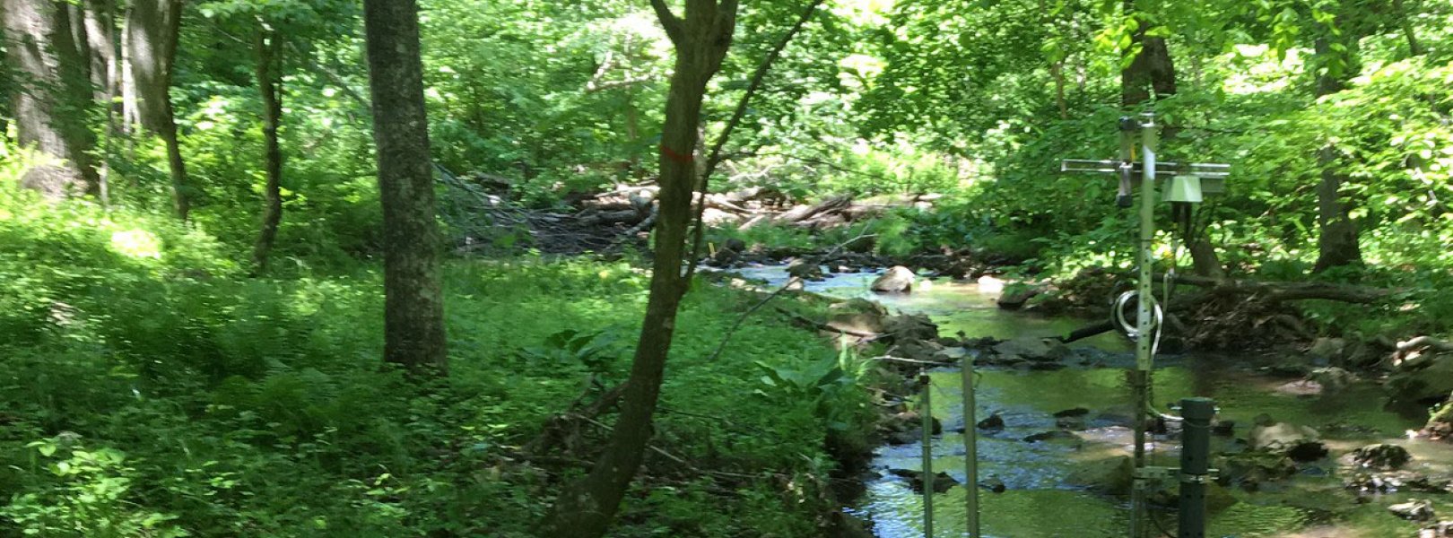
This site has one meteorological station located in the riparian area. The met station is outfitted with a subset of the same sensors used at terrestrial sites. Measurements include wind speed and direction, air temperature, barometric pressure, relative humidity, shortwave radiation, and PAR.

Phenocams

A phenocam is pointed toward the land-water interface of the site. Here we show the images from the most recent hour. The full collection of images can be viewed on the Phenocam Gallery - click on the image below.

NEON.D02.POSE.DP1.20002


Field Site Data

Site

Site Host

Smithsonian Institution

Operations Office

NEON Field Operations Office

Domain 02 Support Facility

NEON Field Operations Address

1500 Remount Road
MRC 5560, Bldg 90
Front Royal, VA 22630

NEON Field Operations Phone

540.692.1919

Location

Latitude

38.89431

Longitude

-78.147258

Geodetic Datum

WGS84

UTM Northing

4308808.69m

UTM Easting

747457.75m

UTM Zone

17N

County

Warren

State

VA

Country

US

Mean Elevation

276m

Climate

Mean Annual Temperature

11.8°C

Mean Annual Precipitation

1090mm

Vegetation

Dominant NLCD Classes

Deciduous Forest

Watershed

USGS HUC

h02070005

Watershed Name

South Fork Shenandoah

Geology

USGS Geology Unit

VACAZc;0

USGS Geology Name

Catoctin Formation - Metabasalt

USGS Lithologic Constituents

Grayish-green to dark-yellowish-green, fine-grained, schistose chlorite- and actinolite-bearing metabasalt, commonly associated with epidosite segregations.

USGS Geology Age

Proterozoic Z to Cambrian


Gallery

  • Photos
  • Videos

No Video


Related Field Sites

Other Domain D02 Field Sites

brown circle white drop icon Blandy Experimental Farm NEON
Gradient Terrestrial
blue circle white drop icon Lewis Run NEON
Gradient Aquatic
brown square white mountain icon Smithsonian Conservation Biology Institute NEON
Core Terrestrial
brown circle white drop icon Smithsonian Environmental Research Center NEON
Gradient Terrestrial

Other Field Sites in VA

brown circle white drop icon Blandy Experimental Farm NEON
Gradient Terrestrial
blue circle white drop icon Lewis Run NEON
Gradient Aquatic
brown circle white drop icon Mountain Lake Biological Station NEON
Gradient Terrestrial
brown square white mountain icon Smithsonian Conservation Biology Institute NEON
Core Terrestrial
NSF NEON, Operated by Battelle

Follow Us:

Join Our Newsletter

Get updates on events, opportunities, and how NEON is being used today.

Subscribe Now

Footer

  • About Us
  • Newsroom
  • Contact Us
  • Terms & Conditions
  • Careers
  • Code of Conduct

Copyright © Battelle, 2025

The National Ecological Observatory Network is a major facility fully funded by the U.S. National Science Foundation.

Any opinions, findings and conclusions or recommendations expressed in this material do not necessarily reflect the views of the U.S. National Science Foundation.