NEON’s Airborne Remote Sensing Flight Season Announced for 2020
March 4, 2020

Interested in planning a ground sampling project in coordination with one of our airborne remote sensing surveys? The 2020 NEON flight schedule is now available. Two aircraft will be deployed June through September to collect data over 20 terrestrial and 11 aquatic sites, covering 9 of the 20 NEON domains.
Each NEON Airborne Observation Platform (AOP) payload consists of an imaging spectrometer, a discrete and waveform light detection and ranging (LIDAR) instrument and a high-resolution digital camera. These instruments are mounted in a DeHavilland DHC-6 Twin Otter aircraft that flies at a nominal altitude of 1000m above ground level (AGL) at a speed of 100 knots over NEON field sites. The flight parameters enable meter-scale spectroscopy, decimeter-scale photography, and ~4 points-per-meter discreet and waveform lidar measurements.
AOP surveys are synchronized with data collected on the ground at each site by NEON field staff. This allows scientists to develop a more comprehensive picture of how different observations scale and how measurements taken from airborne remote sensing instruments correlate with observations made on the ground. Raw data obtained from flights are processed and made available via the NEON data portal ~60 days after collection.
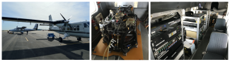
Airborne instrumentation, left: twin otter plane, middle: imaging spectrometer, right: payload inside of the twin otter
Measurements obtained from the AOPs provide a range of physical, biological and biochemical data products available both as flightlines and mosaics, including:
- Topography (elevation, slope and aspect)
- Canopy chemistry (lignin, nitrogen, water content, xanthophyll cycle)
- Ecosystem structure (canopy height and Leaf Area Index (LAI)
- Total biomass maps and vegetation indices
- High-resolution orthorectified camera imagery
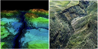
Data products from YELL (D12) site. Left: Discrete lidar point cloud colorized by RGB camera imagery. Right: Digital surface model.
If you would like to plan research activities on the ground to coincide with these surveys, please sign up to join our mailing list. The AOP Flight Operations team will email daily reports on the status of flights over each site which will be more up-to-date than the schedule posted on the website. Although they will attempt adherence to the published schedule, weather and logistical constraints may result in modifications to this plan.
We are likely unable to include additional flight areas to the existing NEON observatory collection plan this year. However, AOP will attempt to accommodate all requests to support Principal Investigator (PI)-led science flights via the NEON Assignable Assets program.
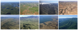
Aerial views of NEON sites
Now, it's time to fly!
Quick Links
- 2020 Flight Schedule
- Overview of an AOP
- Tips for Getting Airborne Data
- Request an Airborne Remote Sensing Survey
- Daily Flight Report Email Sign Up: If you are interested in tracking the 2020 season, you can sign up to receive daily emails by NEON domain. Please note, you will only receive emails during the time period the AOP is in the domain you have signed up to follow
- NEON Data Portal: all data products from 2019 flights are now available for download on the data portal
