Going Out on a Limb with a New Canopy Sampling Method
September 27, 2019
How do you give a 150-foot tree a haircut?
Collecting leaf (foliar) samples from the top of the forest canopy can be difficult and dangerous work. But NEON field teams may soon have an easier way to snip samples with the help of a drone equipped with a robotic sampling device. In July, the Pacific Northwest team tested drone technology from DeLeaves to collect foliar canopy samples at NEON’s terrestrial field site in the Wind River Experimental Forest (WREF), Washington.
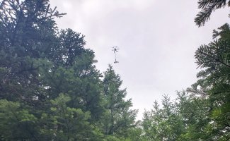
The DeLeaves drone collects a foliar sample from the forest canopy at WREF, WA. July 2019.
Up in the Treetops with DeLeaves
The foliar sampling drone was created by graduate students Guillaume Charron and Hughes La Vigne of the University of Sherbrooke in Quebec, working under Professor Alexis Lussier Desbiens. Guillaume, a mechanical engineering graduate student, said the inspiration for the project came from a collaboration with the University of British Columbia (UBC) Botanical Gardens. “They collect plant samples in remote locations to bring rare species back to the gardens,” he explains. “They needed a faster and safer way to collect targeted samples on expeditions.”
Guillaume and Hughes, an electrical engineering graduate student, created a robotic sampler attached to a quadcopter drone to enable efficient, safe sample collection. The drone is equipped with a camera that allows the operator to select a specific sample target and position the drone by remote control. Once the cutting arm is in position, the cutting and grasping sequence is automated.
After successful expeditions with the UBC Botanical Gardens in Vietnam, the inventors realized that the technology had wider applications for research and forestry. They founded DeLeaves in 2019 to bring their invention to the market.
NEON had already been exploring ways to integrate drones into ongoing ecological research—for example, using drones to collect multispectral image data to pair with airborne remote sensing data. One of the head scientists for this work, Dave Durden, teamed up with Samantha Weintraub, the lead NEON terrestrial biogeochemist, to investigate drone-based methods to improve foliar sampling. Samantha explains, “In the past, we've used traditional arborist tools or line launchers—which are like giant air guns—to collect foliar samples. But these methods tend to be slow and not very precise; it's hard to target the sunlit samples we want from the very top of the canopy. Sending a climber up is slow, dangerous and expensive. Using drones would allow us to get very targeted samples from the canopy top and could really speed up the process.”
[[nid:8580]]
Samantha and Dave were excited to find DeLeaves, and they organized a test run of the technology at WREF in late July 2019. The site is located in the Columbia River Gorge and features trees that can be 40-50m tall—heights that are very difficult to reach with a line launcher. By all metrics, the campaign was a success. The drone collected 11 samples, and each took just ten minutes to acquire, compared to one to two hours for collection of a sample using a line launcher. The DeLeaves team led sample collection for the trial. They also trained Dave on how to use the robotic sampler in the hopes that NEON could acquire one in the near future and use it for sampling other tall-canopy sites across the network. After a half day of training, Dave was able to successfully collect three samples from two mature Douglas fir trees.
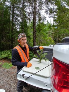
Scientist, Dave Durden holds up a foliar sample collected by the drone, WREF, WA. July 2019.
Studying Canopy Chemistry
Foliar canopy sampling is conducted at all NEON terrestrial sites. Samples of leaves are taken from the upper, sunlit portions of the canopy for chemical and physical analysis. This analysis measures leaf mass per unit area, leaf water content, and chemical compounds in the leaf such as chlorophyll, lignin, nitrogen, carbon, phosphorus, magnesium, iron and stable isotopes of nitrogen and carbon. The chemical content of the leaves is directly related to the plant's capacity for photosynthesis, defense, carbon capture and other biogeochemical activities. Foliar measurements provide important insights into the overall health and productivity of the ecosystem.
Some measurements of canopy chemistry can be gathered through remote sensing. The NEON Airborne Observation Platforms (AOPs) collect hyperspectral data using an imaging spectrometer that measures reflected light energy in narrow spectral bands from 380nm to 2500nm (the visible light spectrum for humans ranges from 380nm to 740nm). Different molecules within the leaf reflect light at different spectra, allowing researchers to extrapolate leaf chemistry from the spectral data.
For some molecules, such as chlorophyll, the relationship between leaf chemistry and spectral data is clear and well understood. But interpreting spectral data for other chemical measurements isn’t as simple. This is especially true for measurements of nutrients like nitrogen and phosphorus, which are used in numerous biochemical pathways by the plant.
Physical foliar samples are needed to provide calibration and validation data to develop and test the accuracy of canopy chemistry models created with remote sensing data. Comparing analysis of physical samples from many different habitats and vegetation types will enable researchers to improve the accuracy of these models and apply them at the continental scale. For accurate comparison, physical foliar samples must be collected from the top, sunlit portions of the canopy that are visible to remote sensing instruments.
The Future of Foliar Canopy Sampling?
The DeLeaves canopy sampling drone could make collection of foliar canopy data much faster, easier and safer for researchers. The drone can fly above the forest canopy so researchers can target the sunlit foliar samples needed for chemical analysis.

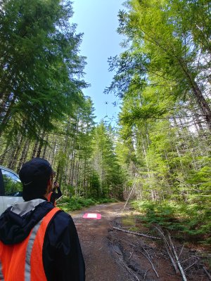
The scientists watch the DeLeaves drone take off to collect foliar samples of the forest canopy, WREF terrestrial field site in the Wind River Experimental Forest, WA. July 2019.
Etienne Laliberté, an Associate Professor at the University of Montreal, also recently collaborated with the DeLeaves team to collect sunlit canopy samples to support the Canadian Airborne Biodiversity Observatory (CABO) project, which uses spectral data to understand how Canadian ecosystems are responding to environmental change. Chemical analysis of leaf samples will help researchers understand how underlying biochemical traits are related to differences in the spectra of light reflected by different plant species. Etienne says, “Generally, the leaves we’ve sampled to date are not at the very top of the canopy but are on the side of the crown of an isolated tree, because our telescopic pole pruners do not allow us to sample the highest leaves of tall trees. The DeLeaves drone helped us to sample those highest leaves relatively easily.” In the future, this could open up sampling of a much wider cross-section of trees, which would enhance projects like Etienne’s.
Samantha and Dave hope to see the DeLeaves drone put to use at additional NEON field sites in 2020. Northern continental forests with tall canopies, such as those found in the eastern seaboard and Great Lakes region, may be the next targets for drone collection. There are still a number of issues to work out at the sites to obtain permitting for drone collection and identify the best areas to target for sampling.
Guillaume and Hughes are continuing to refine the technology. One goal is to expand the camera transmission range, which currently limits collection to roughly 150m from the base station. They also are improving the algorithms for the robotic sampler to further automate sample targeting and collection. The goal is to make a drone that is very easy for field researchers to use with minimal training. “Our objective is to create tools that enable scientists to do their best work,” says Guillaume. “We want to help them overcome limitations in the field so they can get the best possible data.”