NSF NEON, Operated by Battelle

Main navigation

  • About
    • NEON Overview
      • Vision and Management
      • Spatial and Temporal Design
      • History
    • About the NEON Biorepository
      • ASU Biorepository Staff
      • Contact the NEON Biorepository
    • Observatory Blog
    • Newsletters
    • Staff
    • FAQ
    • Contact Us

    About

  • Data
    • Data Portal
      • Data Availability Charts
      • API & GraphQL
      • Prototype Data
      • Externally Hosted Data
    • Data Collection Methods
      • Airborne Observation Platform (AOP)
      • Instrument System (IS)
        • Instrumented Collection Types
        • Aquatic Instrument System (AIS)
        • Terrestrial Instrument System (TIS)
      • Observational System (OS)
        • Observation Types
        • Observational Sampling Design
        • Sampling Schedules
        • Taxonomic Lists Used by Field Staff
        • Optimizing the Observational Sampling Designs
      • Protocols & Standardized Methods
    • Getting Started with NEON Data
      • neonUtilities for R and Python
      • Learning Hub
      • Code Hub
    • Using Data
      • Data Formats and Conventions
      • Released, Provisional, and Revised Data
      • Data Product Bundles
      • Usage Policies
      • Acknowledging and Citing NEON
      • Publishing Research Outputs
    • Data Notifications
    • NEON Data Management
      • Data Availability
      • Data Processing
      • Data Quality

    Data

  • Samples & Specimens
    • Biorepository Sample Portal at ASU
    • About Samples
      • Sample Types
      • Sample Repositories
      • Megapit and Distributed Initial Characterization Soil Archives
    • Finding and Accessing Sample Data
      • Species Checklists
      • Sample Explorer - Relationships and Data
      • Biorepository API
    • Requesting and Using Samples
      • Loans & Archival Requests
      • Usage Policies

    Samples & Specimens

  • Field Sites
    • Field Site Map and Info
    • Spatial Layers & Printable Maps

    Field Sites

  • Resources
    • Getting Started with NEON Data
    • Research Support Services
      • Field Site Coordination
      • Letters of Support
      • Mobile Deployment Platforms
      • Permits and Permissions
      • AOP Flight Campaigns
      • Research Support FAQs
      • Research Support Projects
    • Code Hub
      • neonUtilities for R and Python
      • Code Resources Guidelines
      • Code Resources Submission
      • NEON's GitHub Organization Homepage
    • Learning Hub
      • Tutorials
      • Workshops & Courses
      • Science Videos
      • Teaching Modules
    • Science Seminars and Data Skills Webinars
    • Document Library
    • Funding Opportunities

    Resources

  • Impact
    • Research Highlights
    • Papers & Publications
    • NEON in the News

    Impact

  • Get Involved
    • Upcoming Events
    • Research and Collaborations
      • Environmental Data Science Innovation and Inclusion Lab
      • Collaboration with DOE BER User Facilities and Programs
      • EFI-NEON Ecological Forecasting Challenge
      • NEON Great Lakes User Group
      • NCAR-NEON-Community Collaborations
    • Advisory Groups
      • Science, Technology & Education Advisory Committee
      • Technical Working Groups
    • NEON Ambassador Program
      • Exploring NEON-Derived Data Products Workshop Series
    • Partnerships
    • Community Engagement
    • Work Opportunities

    Get Involved

  • My Account
  • Search

Search

About

  • NEON Overview
  • About the NEON Biorepository
  • Observatory Blog
  • Newsletters
  • Staff
  • FAQ
  • Contact Us

Breadcrumb

  1. About
  2. Observatory Blog
  3. Branching Out Again with Remote Controlled Canopy Sampling

Branching Out Again with Remote Controlled Canopy Sampling

September 22, 2021

Drone takeoff

The National Ecological Observatory Network (NEON) samples sunlit foliage from each of its 47 terrestrial sites on an every-five-year basis, in parallel with remote sensing collection by the NEON Airborne Observation Platform (AOP). The resulting measurements of foliar traits (leaf mass per area, moisture content, and chemistry) help researchers use AOP data to map foliar traits over large landscapes and monitor change in foliar properties over time.

Sampling foliage from tall-stature, closed-canopy forests is no easy task. In 2019, NEON partnered with DeLeaves, a startup company that specializes in aerial robotics, to sample at the Wind River Experimental Forest (WREF) NEON site. A robotic sampler device attached to a drone allowed remote collection of sunlit canopy samples from trees up to 150 feet tall. This campaign demonstrated the potential to reduce complexity and increase the efficiency of sampling operations, with increased safety and access to previously unreachable areas of the trees.

Drone takeoff

Take-off from a narrow opening in the natural forest, piloted by David Durden (NEON). Photo credit: Hughes La Vigne, DeLeaves, captured with a DJI Mavic 2 Pro.

Since then, the DeLeaves sampling system has been commercialized, and major improvements have increased ease of use, efficiency, and range. In August 2021, NEON again partnered with DeLeaves for a campaign at the Smithsonian Environmental Research Center (SERC) field site to validate the scalability of the drone sampling technique.

DeLeaves Drone

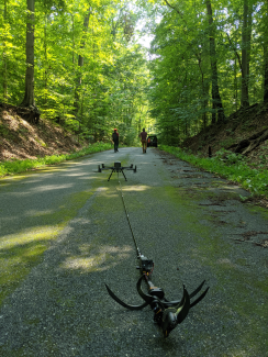
Close-up of the DeLeaves robotic system, ready for take-off. Photo credit: Guillaume Charron, DeLeaves.

Drone samples the canopy

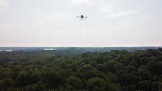
The DJI M300 drone equipped with the DeLeaves tool while bringing back a tree sample collected 150m away from the takeoff point, with Rhode River in the background. Photo credit: Hughes La Vigne, DeLeaves, captured with a DJI Mavic 2 Pro.

During a 4-day period, a total of 40 trees from 18 different species were successfully sampled. The majority of these samples were collected by David Durden, a NEON research scientist who is also a trained drone pilot. "The DeLeaves sampler improvements over the last two years made the sampling process more safe and efficient through a simplified interface and improved obstacle avoidance features," said Durden. "I was comfortable flying missions after one day of training."

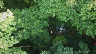
Sampling of sunlight canopy with DeLeaves drone in 2021. Sampling occurred at SERC site, D02. Video credit: Hughes La Vigne, DeLeaves, captured with a DJI Mavic 2 Pro.

Using the coordinates of the target trees, the drone was programmed to fly autonomously to each target, significantly reducing sampling times. "I was impressed with how quickly we were able to obtain samples that were of a higher quality than those we've retrieved with other methods in the past," said Greg Chapman, a NEON field ecologist who leads the plant sampling in Domain 02 region. "It easily reduced the amount of time needed to complete our field campaign by at least half, and removed the frustrations we experience when using line launchers to target tall canopy trees through thick understory and brush, which is an issue at most of our sites." Using the drone altitude also makes it easier to determine the exact height of the sample being collected, further increasing efficiency.

sample collected by drone

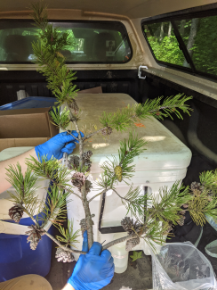
Sample of Virginia pine (Pinus virginiana) with cones, collected with the DeLeaves. Photo credit: Guillaume Charron, DeLeaves.

NEON is excited to continue exploring how autonomous samplers can improve sampling quality, efficiency, and safety, for canopy foliage applications and beyond. The future of cross disciplinary autonomous observations in Earth science will be explored during the "Autonomous Scientific Observations: Building reproducible research today and into the future" town hall, co-chaired by Durden, at the 2021 American Geophysical Union (AGU) Fall meeting.

Share

Related Posts:

Discontinuation of Select NEON Data Products

January 29, 2026

Modification of Select NEON Data Products

January 29, 2026

NEON Operations coming to a close at Dead Lake, Alabama, field site

October 15, 2025

Map with DELA field site marker
NSF NEON, Operated by Battelle

Follow Us:

Join Our Newsletter

Get updates on events, opportunities, and how NEON is being used today.

Subscribe Now

Footer

  • About Us
  • Contact Us
  • Terms & Conditions
  • Careers
  • Code of Conduct

Copyright © Battelle, 2026

The National Ecological Observatory Network is a major facility fully funded by the U.S. National Science Foundation.

Any opinions, findings and conclusions or recommendations expressed in this material do not necessarily reflect the views of the U.S. National Science Foundation.