NSF NEON, Operated by Battelle

Main navigation

  • About Us
    • Overview
      • Spatial and Temporal Design
      • History
    • Vision and Management
    • Advisory Groups
      • Science, Technology & Education Advisory Committee
      • Technical Working Groups (TWGs)
    • FAQ
    • Contact Us
      • Contact NEON Biorepository
      • Field Offices
    • User Accounts
    • Staff
    • Code of Conduct

    About Us

  • Data & Samples
    • Data Portal
      • Explore Data Products
      • Data Availability Charts
      • Spatial Data & Maps
      • Document Library
      • API & GraphQL
      • Prototype Data
      • External Lab Data Ingest (restricted)
    • Data Themes
      • Biogeochemistry
      • Ecohydrology
      • Land Cover and Processes
      • Organisms, Populations, and Communities
    • Samples & Specimens
      • Discover and Use NEON Samples
        • Sample Types
        • Sample Repositories
        • Sample Explorer
        • Megapit and Distributed Initial Characterization Soil Archives
      • Sample Processing
      • Sample Quality
      • Taxonomic Lists
    • Collection Methods
      • Protocols & Standardized Methods
      • Airborne Remote Sensing
        • Flight Box Design
        • Flight Schedules and Coverage
        • Daily Flight Reports
          • AOP Flight Report Sign Up
        • Camera
        • Imaging Spectrometer
        • Lidar
      • Automated Instruments
        • Site Level Sampling Design
        • Sensor Collection Frequency
        • Instrumented Collection Types
          • Meteorology
          • Phenocams
          • Soil Sensors
          • Ground Water
          • Surface Water
      • Observational Sampling
        • Site Level Sampling Design
        • Sampling Schedules
        • Observation Types
          • Aquatic Organisms
            • Aquatic Microbes
            • Fish
            • Macroinvertebrates & Zooplankton
            • Periphyton, Phytoplankton, and Aquatic Plants
          • Terrestrial Organisms
            • Birds
            • Ground Beetles
            • Mosquitoes
            • Small Mammals
            • Soil Microbes
            • Terrestrial Plants
            • Ticks
          • Hydrology & Geomorphology
            • Discharge
            • Geomorphology
          • Biogeochemistry
          • DNA Sequences
          • Pathogens
          • Sediments
          • Soils
            • Soil Descriptions
        • Optimizing the Observational Sampling Designs
    • Data Notifications
    • Data Guidelines and Policies
      • Acknowledging and Citing NEON
      • Publishing Research Outputs
      • Usage Policies
    • Data Management
      • Data Availability
      • Data Formats and Conventions
      • Data Processing
      • Data Quality
      • Data Product Bundles
      • Data Product Revisions and Releases
        • Release 2021
        • Release 2022
        • Release 2023
        • Release 2024
        • Release-2025
      • NEON and Google
      • Externally Hosted Data

    Data & Samples

  • Field Sites
    • About Field Sites and Domains
    • Explore Field Sites
    • Site Management Data Product

    Field Sites

  • Impact
    • Observatory Blog
    • Case Studies
    • Papers & Publications
    • Newsroom
      • NEON in the News
      • Newsletter Archive
      • Newsletter Sign Up

    Impact

  • Resources
    • Getting Started with NEON Data & Resources
    • Documents and Communication Resources
      • Papers & Publications
      • Document Library
      • Outreach Materials
    • Code Hub
      • Code Resources Guidelines
      • Code Resources Submission
      • NEON's GitHub Organization Homepage
    • Learning Hub
      • Science Videos
      • Tutorials
      • Workshops & Courses
      • Teaching Modules
    • Research Support Services
      • Field Site Coordination
      • Letters of Support
      • Mobile Deployment Platforms
      • Permits and Permissions
      • AOP Flight Campaigns
      • Research Support FAQs
      • Research Support Projects
    • Funding Opportunities

    Resources

  • Get Involved
    • Advisory Groups
      • Science, Technology & Education Advisory Committee
      • Technical Working Groups
    • Upcoming Events
    • NEON Ambassador Program
      • Exploring NEON-Derived Data Products Workshop Series
    • Research and Collaborations
      • Environmental Data Science Innovation and Inclusion Lab
      • Collaboration with DOE BER User Facilities and Programs
      • EFI-NEON Ecological Forecasting Challenge
      • NEON Great Lakes User Group
      • NEON Science Summit
      • NCAR-NEON-Community Collaborations
        • NCAR-NEON Community Steering Committee
    • Community Engagement
      • How Community Feedback Impacts NEON Operations
    • Science Seminars and Data Skills Webinars
      • Past Years
    • Work Opportunities
      • Careers
      • Seasonal Fieldwork
      • Internships
        • Intern Alumni
    • Partners

    Get Involved

  • My Account
  • Search

Search

Field Sites

  • About Field Sites and Domains
  • Explore Field Sites
  • Site Management Data Product

Breadcrumb

  1. Field Sites
  2. Toolik Field Station NEON

Field Site

Toolik Field Station NEON / TOOL

brown square white mountain icon

Core Terrestrial, AK, D18: Tundra

Flux tower at TOOL in November

About Field Sites

Toolik Lake Research Natural Area (TOOL) is a terrestrial NEON field site near Toolik Field Station, AK, just north of the Brooks Range. The 60 km2 (14,800 acre) site is located 254.3 km (158 mi.) above the Arctic Circle and 188 km (116 mi.) from the Arctic Ocean. TOOL’s field sampling area is managed by the Bureau of Land Management as a Resource Natural Area and Area of Critical Environmental Concern, but housing and logistics are supported by Toolik Field Station (TFS). TFS is operated by the Institute of Arctic Biology at the University of Alaska Fairbanks, with cooperative agreement support from the Division of Polar Programs, Directorate for Geosciences at the National Science Foundation. TOOL sits at 700 - 985 m (2300 - 3200 ft.) above sea-level, which demarcates taiga and tundra ecosystems in Alaska. It provides a contrast to BARR, which is on the northern coastal floodplains. In both cases, field site boundaries overlap other ecological research networks, allowing opportunities for larger datasets and longer time series. TOOL is part of the NEON Tundra Domain (D18), which includes the northern and western parts of Alaska. D18 hosts three other NEON field sites in Alaska: two aquatic sites and the BARR terrestrial site. TOOL is colocated with the two D18 aquatic sites, Toolik Lake (TOOK) and Oksrukuyik Creek (OKSR). [1] [3]

Climate

The climate at TOOL is characterized by long, cold winters; short, cool summers; and extreme seasonal variation. In the absence of sunlight, winters are long and bitterly cold, with temperatures sometimes reaching -40°C (-40°F) or lower. The summer period brings 24-hour solar input for much of June-August; as a result, it is the only time of year where average temperatures exceed 0°C (32°F). TOOL has an average mean temperature of -9°C (16°F) and it receives a mean annual precipitation of 316 mm (12.4 in). [2] [7]

Geology

The majority of TOOL is located on rolling till plains and moraines with various superposed periglacial features that include stripes, non-sorted circles and thermokarst pits. Glacial and alluvial deposits from the Holocene age blanket the area. The site is also located in a continuous permafrost zone; however, taliks - pockets of non-frozen material - often underlie lakes and rivers. [13] [14]

Soils

TOOL is located on rolling till plains and moraines. The lowlands have a thick organic layer, while the higher located soils are gelic (frost-churned) and exposed at the surface. Soils at TOOL contain permafrost as the site is located in the zone of continuous permafrost. The soils are characterized as Typic Histoturbels in the order Gelisols. These soils have a thick layer of organic matter at the surface and are often saturated for long periods of time. The high organic matter in the soils at TOOL is mostly due to persistent cold temperatures, which limit decomposition and promote the accumulation of organic material from vegetation. This organic material insulates the underlying permafrost. [8] [9] [14] [15]

Hydrology

The landscape’s permafrost plays a major role in soil hydrology at TOOL. Climate warming brings increasing disruption to soil moisture and water table connectivity from melting permafrost layers. While solid permafrost plays a role in directing water flow, subsurface flow also impacts permafrost volume through the transfer of thermal energy via heat advection. [16] [17]

Vegetation

TOOL is dominated by tussock tundra, a vegetation type that covers some 80% of arctic Alaska. Bigelow Sedge (Carex bigelowii) and tussock cottongrass (Eriophorum vaginatum) are especially abundant. Low shrubs, including dwarf birch (Betula glandulosa or nana) and diamond-leaf willow (Salix pulchra), grow between the tussocks and along the streams. Vaccinium vitis-idaea is also common. NEON evaluates plant diversity and percent cover in various plots across the site on an annual basis. [1]

Fauna

The station has a long list of notable wildlife, but mammals commonly seen in the area include caribou (Rangifer tarandus), muskox (Ovibos moschatus), and red fox (Vulpes vulpes). Terrestrial field technicians collect data on small mammals, beetles, ticks, and mosquitoes, the last of which emerge in great numbers during the peak of the growing season. Aquatic field technicians collect fish data from the nearby creek and Toolik Lake. Finally, bird surveys are performed annually to collect data on breeding land birds, including species coming from Africa and Asia, such as northern wheatears (Oenanthe oenanthe) and bluethroats (Luscinia svecica). The logo for Toolik Field Station features a yellow-billed loon (Gavia adamsii), which can be commonly seen or heard on Toolik Lake during the breeding season. [10]

Past Land Management and Use

Human inhabitation in Alaska has been dated back to at least the Pleistocene (11,500 years ago), with evidence of Paleo-Arctic Tradition at the Upper Sun River archaeological site.

Scientific research at Toolik began in 1975, providing baseline aquatic data as part of the National Science Foundation’s project called Research on Arctic Tundra Environments. With consistent collaboration between the National Science Foundation and the University of Alaska Fairbanks, infrastructure developed over the years to make Toolik Field Station one of the premier arctic research lab and support facilities in the world today. [18] [20] [21]

Current Land Management and Use

Owned by the Bureau of Land Management, the land which supports NEON’s terrestrial sampling is protected as both a Resource Natural Area and an Area of Critical Environmental Concern (ACEC). The 335 km2 (129 sq. mi.) unit does not allow for recreational camping nor commercial mining. Largely, the land is undisturbed and preserved for field research. For that reason, Toolik Field Station is one of the premier locations to study arctic science. TFS supports researchers from all around the world, with a capacity of over 100 users. Despite the remoteness and lack of development in the sampling area, there is one manmade structure that cannot go unnoticed. Built between 1975 and 1977, the Trans-Alaska Pipeline System precedes the establishment of the reserve; however, it has little direct environmental impact. Running from Prudhoe Bay near the Arctic Ocean to Valdez, on the Southern Coast of Alaska, the 1.21 m (4 ft.) diameter, 1287 km (800 mi.) pipeline can be seen from various parts of the sampling boundary. [1] [4] [5]

NEON Site Establishment

The plot establishment and initial sampling readiness review in TOOL began in July 2017. Dry runs of observational sampling began in late 2017. Instrumentation systems went online and began producing data in March 2017.

Additional Resources

[1] Terrestrial Observation System (TOS) Site Characterization Report: Domain 18. NEON.DOC.003901vB

[2] National Oceanic and Atmospheric Administration National Centers for Environmental Information’s (NCEI) 1981-2010 climate normals (NCEI 2015). https://toolik.alaska.edu/edc/abiotic_monitoring/metdata_summaries.php

[3] Institute for Arctic Biology. IAB Facilities. Retrieved from https://www.iab.uaf.edu/research/facilities on May 24 2020

[4] Alaska Department of Natural Resources, Division of Oil And Gas. Retrieved 2020. Trans-Alaska Pipeline System http://dog.dnr.alaska.gov/Services/Pipelines?pipeline=Trans-Alaska%20Pi…

[5] Bureau of Land Management, (1989). PROPOSED RESOURCE MANAGEMENT PLAN and FINAL ENVIRONMENTAL IMPACT STATEMENT for the UTILITY CORRIDOR PLANNING AREA ARCTIC DISTRICT, ALASKA.

[6] Toolik Field Station (2013). Toolik Field Station Long Range Facilities Plan

[7] Institute for Arctic Biology, University of Alaska, Fairbanks, 2016. Toolik field station fact sheet.

[8] Overview of Environmental and Hydrogeologic Conditions at Barrow, Alaska. U.S. Geological Survey. 1994. https://pubs.usgs.gov/of/1994/0322/report.pdf

[9] Michael SanClements, Robert H Lee, E D Ayres, Keli Goodman, Morgan Jones, David Durden, Katherine Thibault, Rommel Zulueta, Joshua Roberti, Claire Lunch, Adrian Gallo, Collaborating with NEON, BioScience, Volume 70, Issue 2, February 2020, Page 107, https://doi.org/10.1093/biosci/biaa005

[10] Environmental Data Center Team. 2020. Toolik mammal sightings. Toolik Field Station, Institute of Arctic Biology, University of Alaska Fairbanks, Fairbanks, AK 99775. http://toolik.alaska.edu/edc/biotic/monitoring/mammal_guide.php

[11] Environmental Data Center Team. 2020. Toolik bird monitoring program. Toolik Field Station, Institute of Arctic Biology, University of Alaska Fairbanks, Fairbanks, AK 99775. http://toolik.alaska.edu/edc/biotic_monitoring/bird_guide.php

[12] National Resources Conservation Service (2002). Toolik Lake, Moist acidic tundra. S98AK-185-002. USDA

[13] U.S. Geological Survey, 2005, Mineral Resources Data System: U.S. Geological Survey, Reston, Virginia. https://mrdata.usgs.gov/mrds/

[14] Mulligan, D. (2019) NEON site-level plot summary toolik lake (TOOL). USDA.

[15] Swanson, D. K. (2002). Soil Survey of Gerstle River Area, Alaska. pg 209.

[16] de Grandpré I. Fortier D. Sephan E.. 2012. Degradation of permafrost beneath a road embankment enhanced by heat advected in groundwater. Can. J. Earth Sci. 49:953–962. doi:10.1139/e2012-018

[17] Michelle A. Walvoord, Barret L. Kurylyk; Hydrologic Impacts of Thawing Permafrost—A Review. Vadose Zone Journal ; 15 (6): vzj2016.01.0010. doi: https://doi.org/10.2136/vzj2016.01.0010

[18] Virtual Herbarium. 2020. Toolik Field Station, Institute of Arctic Biology, University of Alaska Fairbanks, Fairbanks, AK 99775. https://toolik.alaska.edu/edc/biotic_monitoring/virtual_herbarium.php

[19] Carroll, A. B., Parker, C., & Craig, T. (2003). Toolik Lake research natural area/ACEC rare plant inventory, 2002. BLM-Alaska Open File Report 90. BLM/AK/ST-03/010+ 6700+ 025.

[20] History of Toolik. 2020. Toolik Field Station, Institute of Arctic Biology, University of Alaska Fairbanks, Fairbanks, AK 99775. https://toolik.alaska.edu/about/history.php

[21] Potter, B. A., Irish, J. D., Reuther, J. D., & McKinney, H. J. (2014). New insights into Eastern Beringian mortuary behavior: a terminal Pleistocene double infant burial at Upward Sun River. Proceedings of the National Academy of Sciences of the United States of America, 111(48), 17060–17065. https://doi.org/10.1073/pnas.1413131111

Field Site Information

Latitude/Longitude

68.66109, -149.37047

Geodetic Datum

WGS84

Location

North Slope County
AK, US

Elevation

Mean: 832m
Minimum: 704m
Maximum: 980m

Mean Annual Temperature

-9.0°C

Dominant Wind Direction

S

Mean Canopy Height

0.3m

Dominant NLCD Classes

Dwarf Scrub, Shrub/Scrub

Colocated Site(s)

Toolik Lake NEON
Oksrukuyik Creek NEON

Colocated Research

North Slope Science Initiative
University of Alaska - Toolik Field Station
Arctic LTER
Toolik Field Station National Atmospheric Deposition Program
Critical Zone Exploration Network
Ameriflux
NOAA U.S. Climate Reference Network

Field Operations Office

3352 College Rd.
Fairbanks, AK 99709

Research Access

Non-NEON research activities are allowed in this area. Researchers must obtain their own permits with the site host(s).

Request Access

Observation Types

Remote Sensing

Remote sensing surveys of this field site collect lidar, spectrometer and high-resolution RGB camera data.

Meteorological Measurements

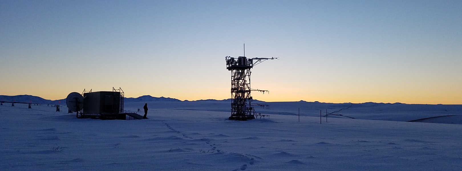
This site has a flux/meteorological tower that is 9 m (30 ft) tall with four measurement levels. The tower top extends above the vegetation canopy to allow sensors mounted at the top and along the tower to capture the full profile of atmospheric conditions from the top of the vegetation canopy to the ground. The tower collects physical and chemical properties of atmosphere-related processes, such as humidity, wind, and net ecosystem gas exchange. Precipitation data are collected by a Double Fence Intercomparison Reference (DFIR) near the tower.

Phenocams

One phenocam is attached to the top and the bottom of the tower. Here we show the images from the most recent hour. The full collection of images can be viewed on the Phenocam Gallery - click on either of the images below.

Tower top

NEON.D18.TOOL.DP1.10033

Tower bottom

NEON.D18.TOOL.DP1.10042

Soil Sensor Measurements

This site has five soil plots placed in an array within the airshed of the flux tower. Photosynthetically Active Radiation (PAR) at soil surface, soil heat flux, solar radiation, and throughfall are measured at the soil surface in each soil plot. Soil moisture, soil temperature, and CO2 concentration are measured at multiple depths in each soil plot.

Observational Sampling

At terrestrial sites, field ecologists observe birds and plants, and sample ground beetles, mosquitoes, small mammals, soil microbes, and ticks. Lab analyses are carried out to provide further data on DNA sequences, pathogens, soils, sediments, and biogeochemistry. Learn more about terrestrial observations or explore this site's data products.


Field Site Data

Site

Site Host

Bureau of Land Management

Site Access Allowed

Yes

Site URL

https://toolik.alaska.edu/user_guide/permits.php

Site Access Details

Reseachers should coordinate with the site manager and submit a site research permit via Toolik Field Station.

Operations Office

NEON Field Operations Office

Domain 18/19 Support Facility

NEON Field Operations Address

3352 College Rd.
Fairbanks, AK 99709

NEON Field Operations Phone

907.459.5040

Location

Latitude

68.66109

Longitude

-149.37047

Geodetic Datum

WGS84

UTM Northing

7618427.66m

UTM Easting

403757.15m

UTM Zone

6N

County

North Slope

State

AK

Country

US

Mean Elevation

832m

Minimum Elevation

704m

Maximum Elevation

980m

Climate

Mean Annual Temperature

-9.0°C

Mean Annual Precipitation

316mm

Dominant Wind Direction

S

Vegetation

Mean Canopy Height

0.3m

Dominant NLCD Classes

Dwarf Scrub, Shrub/Scrub

Average number of green days

80

Average first greenness increase date

160 DOY

Average peak green date

185 DOY

Average first greenness decrease date

205 DOY

Average minimum greenness date

240 DOY

Tower

Tower Height

9m

Number of Tower Levels

4

Soils

Megapit Soil Family

Loamy-skeletal - mixed - superactive - acid - pergelic Typic Histoturbels

Soil Subgroup

Typic Histoturbels


Gallery

  • Photos
  • Videos

Related Field Sites

Other Domain D18 Field Sites

blue square white drop icon Oksrukuyik Creek NEON
Core Aquatic
blue circle white drop icon Toolik Lake NEON
Gradient Aquatic
brown circle white drop icon Utqiaġvik NEON
Gradient Terrestrial

Other Field Sites in AK

blue square white drop icon Caribou Creek NEON
Core Aquatic
brown square white mountain icon Caribou-Poker Creeks Research Watershed NEON
Core Terrestrial
brown circle white drop icon Delta Junction NEON
Gradient Terrestrial
brown circle white drop icon Healy NEON
Gradient Terrestrial
blue square white drop icon Oksrukuyik Creek NEON
Core Aquatic
blue circle white drop icon Toolik Lake NEON
Gradient Aquatic
brown circle white drop icon Utqiaġvik NEON
Gradient Terrestrial
NSF NEON, Operated by Battelle

Follow Us:

Join Our Newsletter

Get updates on events, opportunities, and how NEON is being used today.

Subscribe Now

Footer

  • About Us
  • Newsroom
  • Contact Us
  • Terms & Conditions
  • Careers
  • Code of Conduct

Copyright © Battelle, 2025

The National Ecological Observatory Network is a major facility fully funded by the U.S. National Science Foundation.

Any opinions, findings and conclusions or recommendations expressed in this material do not necessarily reflect the views of the U.S. National Science Foundation.