NSF NEON, Operated by Battelle

Main navigation

  • About Us
    • Overview
      • Spatial and Temporal Design
      • History
    • Vision and Management
    • Advisory Groups
      • Science, Technology & Education Advisory Committee
      • Technical Working Groups (TWGs)
    • FAQ
    • Contact Us
      • Contact NEON Biorepository
      • Field Offices
    • User Accounts
    • Staff
    • Code of Conduct

    About Us

  • Data & Samples
    • Data Portal
      • Explore Data Products
      • Data Availability Charts
      • Spatial Data & Maps
      • Document Library
      • API & GraphQL
      • Prototype Data
      • External Lab Data Ingest (restricted)
    • Data Themes
      • Biogeochemistry
      • Ecohydrology
      • Land Cover and Processes
      • Organisms, Populations, and Communities
    • Samples & Specimens
      • Discover and Use NEON Samples
        • Sample Types
        • Sample Repositories
        • Sample Explorer
        • Megapit and Distributed Initial Characterization Soil Archives
      • Sample Processing
      • Sample Quality
      • Taxonomic Lists
    • Collection Methods
      • Protocols & Standardized Methods
      • Airborne Remote Sensing
        • Flight Box Design
        • Flight Schedules and Coverage
        • Daily Flight Reports
          • AOP Flight Report Sign Up
        • Camera
        • Imaging Spectrometer
        • Lidar
      • Automated Instruments
        • Site Level Sampling Design
        • Sensor Collection Frequency
        • Instrumented Collection Types
          • Meteorology
          • Phenocams
          • Soil Sensors
          • Ground Water
          • Surface Water
      • Observational Sampling
        • Site Level Sampling Design
        • Sampling Schedules
        • Observation Types
          • Aquatic Organisms
            • Aquatic Microbes
            • Fish
            • Macroinvertebrates & Zooplankton
            • Periphyton, Phytoplankton, and Aquatic Plants
          • Terrestrial Organisms
            • Birds
            • Ground Beetles
            • Mosquitoes
            • Small Mammals
            • Soil Microbes
            • Terrestrial Plants
            • Ticks
          • Hydrology & Geomorphology
            • Discharge
            • Geomorphology
          • Biogeochemistry
          • DNA Sequences
          • Pathogens
          • Sediments
          • Soils
            • Soil Descriptions
        • Optimizing the Observational Sampling Designs
    • Data Notifications
    • Data Guidelines and Policies
      • Acknowledging and Citing NEON
      • Publishing Research Outputs
      • Usage Policies
    • Data Management
      • Data Availability
      • Data Formats and Conventions
      • Data Processing
      • Data Quality
      • Data Product Bundles
      • Data Product Revisions and Releases
        • Release 2021
        • Release 2022
        • Release 2023
        • Release 2024
        • Release-2025
      • NEON and Google
      • Externally Hosted Data

    Data & Samples

  • Field Sites
    • About Field Sites and Domains
    • Explore Field Sites
    • Site Management Data Product

    Field Sites

  • Impact
    • Observatory Blog
    • Case Studies
    • Papers & Publications
    • Newsroom
      • NEON in the News
      • Newsletter Archive
      • Newsletter Sign Up

    Impact

  • Resources
    • Getting Started with NEON Data & Resources
    • Documents and Communication Resources
      • Papers & Publications
      • Document Library
      • Outreach Materials
    • Code Hub
      • Code Resources Guidelines
      • Code Resources Submission
      • NEON's GitHub Organization Homepage
    • Learning Hub
      • Science Videos
      • Tutorials
      • Workshops & Courses
      • Teaching Modules
    • Research Support Services
      • Field Site Coordination
      • Letters of Support
      • Mobile Deployment Platforms
      • Permits and Permissions
      • AOP Flight Campaigns
      • Research Support FAQs
      • Research Support Projects
    • Funding Opportunities

    Resources

  • Get Involved
    • Advisory Groups
      • Science, Technology & Education Advisory Committee
      • Technical Working Groups
    • Upcoming Events
    • NEON Ambassador Program
      • Exploring NEON-Derived Data Products Workshop Series
    • Research and Collaborations
      • Environmental Data Science Innovation and Inclusion Lab
      • Collaboration with DOE BER User Facilities and Programs
      • EFI-NEON Ecological Forecasting Challenge
      • NEON Great Lakes User Group
      • NEON Science Summit
      • NCAR-NEON-Community Collaborations
        • NCAR-NEON Community Steering Committee
    • Community Engagement
      • How Community Feedback Impacts NEON Operations
    • Science Seminars and Data Skills Webinars
      • Past Years
    • Work Opportunities
      • Careers
      • Seasonal Fieldwork
      • Internships
        • Intern Alumni
    • Partners

    Get Involved

  • My Account
  • Search

Search

Impact

  • Observatory Blog
  • Case Studies
  • Papers & Publications
  • Newsroom

Breadcrumb

  1. Impact
  2. Observatory Blog
  3. Learning on the fly

Learning on the fly

June 19, 2012

By M. Johnson

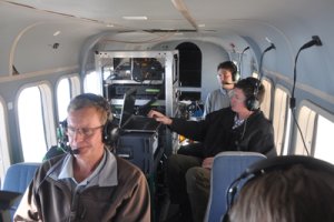
I got a little nervous as I watched the first group of people disembarking the plane and saw one of my AOP team members carrying two little white bags. I’ve never had a weak stomach or gotten motion sickness, but I’d also never flown on such a small plane while having to watch a computer screen before, either. I really didn’t want to puke on the job. But how thrilling it was to finally be out in the field, ready to fly! Weaving through the planes in the hangar, watching the mechanics work, smelling the jet fuel – it was an exhilaratingly unfamiliar environment. I was excited to get up in the air, despite the possibility of needing to use a sick bag. Fortunately, through the turbulence and length of the seven flights I was on, my stomach proved to be unyielding! (Let’s hope it stays that way.)

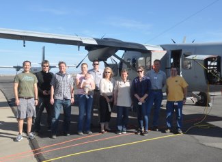
Our inaugural flight campaign lasted about 3 weeks and started out in Grand Junction, Colo., because that’s where Twin Otter International is based. Tom, Nate, and Edwin went out a few days ahead of the rest of the team to integrate the system into the plane and get FAA approval. We were joined by a few of our JPL colleagues and the LiDAR guys from Optech to help with integration and flight operations. Our flights in this region consisted of operator training for, and various calibrations of, the LiDAR system; wiggle timing tests for the imaging spectrometer; and flights over areas we thought would give us some interesting data to process – including the Grand Mesa and an area in the San Juan mountains near Telluride. It was breathtaking to see these areas from above: the myriad of half frozen lakes on Grand Mesa, the vibrant red color and deep crevices of the Colorado National Monument, jagged snowcapped peaks, and the stark contrast between the natural arid landscape and the green patchwork fields of the local farms.

From there, we ferried out to Las Vegas to do some calibration flights for the spectrometer over Ivanpah Playa. We had planned for two cross-calibrations, one with AVIRIS Classic and one with Landsat7, in addition to our own calibration flight plans. Unfortunately, the ER-2 that AVIRIS was installed on had engine trouble and wouldn’t be fixed before we had planned to go home. Instead, we quickly put together a flight plan over Cuprite, Nev., a mineral mining area that has been used in other remote sensing studies. We may not have had the same kind of scenery on this leg of the trip, but we sure got our fair share of turbulence – that desert air moving over the hills can really throw the Twin Otter around! Since this was our first flight campaign, we knew that it was going to be a whale of a learning experience. It was the first time any of us would be operating instruments in the plane, and the first time ever running the LiDAR system (because it’s not something you can safely operate in the lab). We quickly learned the common problems and solutions for pre- and in-flight operations, as well as our personal limits while in flight (i.e. we need to keep some Dramamine on hand for a couple of our team members).

We also ran into a few slightly larger bumps in the road. In Grand Junction, we were grounded for two days due to an unexpected vacuum leak (a valve was completely missing an O-ring), and in Las Vegas we were delayed for half a day because the computer that controls the LiDAR system wouldn’t even boot up. We really had to roll with the punches on our final day of flights, a day that was planned to coincide with the Landsat 7 overpass, because we couldn’t connect to the IMU on the LiDAR system – which meant we couldn’t use our flight plans, and we couldn’t fire the laser. Luckily, 1) this was the day after the computer wouldn’t boot, so Nate had made sure I knew where to find the coordinates in the flight plan files in case we ran into a similar problem and 2) we had great pilots, Kerry and Cameron. We wrote out the starting and ending points for the pilots so they could enter them into their GPS by hand – Cameron was entering in the last points when we made it down to the playa, and we had about 20 minutes before the Landsat overpass. I wasn’t physically running an instrument on this flight but, in a way, I was running the plane. I told the pilots which lines to run, at what time, and at what altitude. In spite of the stress that accompanied this flight, it was successful – we got the data we wanted and needed for calibrations of the spectrometer. I learned a lot in the course of this campaign. Probably the most important lesson was that you can plan out the day’s flights down to the very last detail but you’ve still got to be flexible and work with whatever the day throws at you – whether it’s changing weather, computer problems, equipment malfunctions or cancelled plans. (A close second to this lesson is to make sure there are plenty of sick bags on the plane. I’m just saying, better safe than sorry.) Now that we’ve got a better idea what we’re up against in our future campaigns, I’m excited to get back in the plane in August out at the Harvard Forest site!

Share

Related Posts:

A Chance for Fire Research and Recovery at a NEON Desert Site

January 24, 2025

Burned cactus

AOP Data Availability Notification – Release 2025

January 10, 2025

2024 in Photos: A Look Back Across the Observatory

December 30, 2024

Flux tower in snow
NSF NEON, Operated by Battelle

Follow Us:

Join Our Newsletter

Get updates on events, opportunities, and how NEON is being used today.

Subscribe Now

Footer

  • About Us
  • Newsroom
  • Contact Us
  • Terms & Conditions
  • Careers
  • Code of Conduct

Copyright © Battelle, 2025

The National Ecological Observatory Network is a major facility fully funded by the U.S. National Science Foundation.

Any opinions, findings and conclusions or recommendations expressed in this material do not necessarily reflect the views of the U.S. National Science Foundation.