NSF NEON, Operated by Battelle

Main navigation

  • About Us
    • Overview
      • Spatial and Temporal Design
      • History
    • Vision and Management
    • Advisory Groups
      • Science, Technology & Education Advisory Committee
      • Technical Working Groups (TWGs)
    • FAQ
    • Contact Us
      • Contact NEON Biorepository
      • Field Offices
    • User Accounts
    • Staff
    • Code of Conduct

    About Us

  • Data & Samples
    • Data Portal
      • Explore Data Products
      • Data Availability Charts
      • Spatial Data & Maps
      • Document Library
      • API & GraphQL
      • Prototype Data
      • External Lab Data Ingest (restricted)
    • Data Themes
      • Biogeochemistry
      • Ecohydrology
      • Land Cover and Processes
      • Organisms, Populations, and Communities
    • Samples & Specimens
      • Discover and Use NEON Samples
        • Sample Types
        • Sample Repositories
        • Sample Explorer
        • Megapit and Distributed Initial Characterization Soil Archives
      • Sample Processing
      • Sample Quality
      • Taxonomic Lists
    • Collection Methods
      • Protocols & Standardized Methods
      • Airborne Remote Sensing
        • Flight Box Design
        • Flight Schedules and Coverage
        • Daily Flight Reports
          • AOP Flight Report Sign Up
        • Camera
        • Imaging Spectrometer
        • Lidar
      • Automated Instruments
        • Site Level Sampling Design
        • Sensor Collection Frequency
        • Instrumented Collection Types
          • Meteorology
          • Phenocams
          • Soil Sensors
          • Ground Water
          • Surface Water
      • Observational Sampling
        • Site Level Sampling Design
        • Sampling Schedules
        • Observation Types
          • Aquatic Organisms
            • Aquatic Microbes
            • Fish
            • Macroinvertebrates & Zooplankton
            • Periphyton, Phytoplankton, and Aquatic Plants
          • Terrestrial Organisms
            • Birds
            • Ground Beetles
            • Mosquitoes
            • Small Mammals
            • Soil Microbes
            • Terrestrial Plants
            • Ticks
          • Hydrology & Geomorphology
            • Discharge
            • Geomorphology
          • Biogeochemistry
          • DNA Sequences
          • Pathogens
          • Sediments
          • Soils
            • Soil Descriptions
        • Optimizing the Observational Sampling Designs
    • Data Notifications
    • Data Guidelines and Policies
      • Acknowledging and Citing NEON
      • Publishing Research Outputs
      • Usage Policies
    • Data Management
      • Data Availability
      • Data Formats and Conventions
      • Data Processing
      • Data Quality
      • Data Product Bundles
      • Data Product Revisions and Releases
        • Release 2021
        • Release 2022
        • Release 2023
        • Release 2024
        • Release-2025
      • NEON and Google
      • Externally Hosted Data

    Data & Samples

  • Field Sites
    • About Field Sites and Domains
    • Explore Field Sites
    • Site Management Data Product

    Field Sites

  • Impact
    • Observatory Blog
    • Case Studies
    • Papers & Publications
    • Newsroom
      • NEON in the News
      • Newsletter Archive
      • Newsletter Sign Up

    Impact

  • Resources
    • Getting Started with NEON Data & Resources
    • Documents and Communication Resources
      • Papers & Publications
      • Document Library
      • Outreach Materials
    • Code Hub
      • Code Resources Guidelines
      • Code Resources Submission
      • NEON's GitHub Organization Homepage
    • Learning Hub
      • Science Videos
      • Tutorials
      • Workshops & Courses
      • Teaching Modules
    • Research Support Services
      • Field Site Coordination
      • Letters of Support
      • Mobile Deployment Platforms
      • Permits and Permissions
      • AOP Flight Campaigns
      • Research Support FAQs
      • Research Support Projects
    • Funding Opportunities

    Resources

  • Get Involved
    • Advisory Groups
      • Science, Technology & Education Advisory Committee
      • Technical Working Groups
    • Upcoming Events
    • NEON Ambassador Program
      • Exploring NEON-Derived Data Products Workshop Series
    • Research and Collaborations
      • Environmental Data Science Innovation and Inclusion Lab
      • Collaboration with DOE BER User Facilities and Programs
      • EFI-NEON Ecological Forecasting Challenge
      • NEON Great Lakes User Group
      • NEON Science Summit
      • NCAR-NEON-Community Collaborations
        • NCAR-NEON Community Steering Committee
    • Community Engagement
      • How Community Feedback Impacts NEON Operations
    • Science Seminars and Data Skills Webinars
      • Past Years
    • Work Opportunities
      • Careers
      • Seasonal Fieldwork
      • Internships
        • Intern Alumni
    • Partners

    Get Involved

  • My Account
  • Search

Search

Impact

  • Observatory Blog
  • Case Studies
  • Papers & Publications
  • Newsroom

Breadcrumb

  1. Impact
  2. Observatory Blog
  3. AOP Releases Analysis Ready Data to Investigate Scaling

Data Notification

AOP Releases Analysis Ready Data to Investigate Scaling

April 22, 2021

Are you interested in investigating spatial and spectral relationships between high resolution airborne hyperspectral data and satellite observations? Using its Airborne Observation Platform (AOP), the National Ecological Observatory Network (NEON) collects high spatial and spectral resolution optical remote sensing data at the NEON field sites. Further details on NEON’s AOP and sensors can be found here.

For each acquisition, the AOP collects data over a minimum area of 100 km2 that encompasses observational plots where NEON also conducts intensive field sampling. The AOP collection parameters are designed to allow relationships to be modeled between point scale observations made through the in-situ field samples and the regional landscape observed by the AOP. Regions covered by AOP will also overlap pixels from Earth Observing Satellites (EOS), such as Landsat. As such, the AOP provides an intermediate scale to transfer models derived from detailed point scale field measurements to satellite observations with global coverage.

Timing of AOP flights are constrained by local peak greenness, clouds, and sun angle in addition to local weather conditions. These constraints drive the timing and duration of AOP acquisitions at each of the NEON sites. AOP surveys are conducted during periods when vegetative greenness is greater than 90% of historical maximums, and deployment duration allows a higher likelihood of collection in clear weather conditions. Given these constraints, it is not typically feasible to specifically plan for a co-acquisition with an EOS. Simultaneous coincident collections with EOS may occur, but exact timing and weather conditions may not be ideal.

To address the need for an ideal data set for investigating relationships between the high spatial and spectral resolution AOP data and EOS, NEON conducted a dedicated flight campaign in September, 2020. This resulted in a successful collection of a portion of our CPER field site on Sept. 12th in conjunction with a Landsat7 overpass and on Sept. 13th with both a Landsat8 and Sentinel 2A (Figure 1) . All acquisitions were successfully collected within our normal acquisition criteria and without presence of cloud cover. The AOP overlap with Landsat 7 is sparse due to the scan line corrector malfunction on Landsat 7 (Figure 2); however, a large number of coincident pixels do exist for comparison. In addition to the airborne collections, NEON deployed a ground team to the site each day to collect high accuracy field spectroscopy with a portable Analytical Spectral Device (ASD) field spectrometer over common land cover types including calibration tarps.

AOP hyperspectral image and Landsat 8

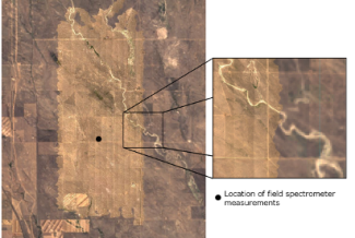
Figure 1. NEON AOP airborne hyperspectral imagery overlaid on coincident collection of Landsat 8 on Sept. 13th, 2020

AOP hyperspectral data and Landsat 7

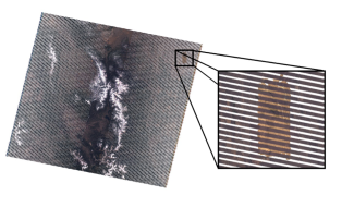
Figure 2. NEON AOP airborne hyperspectral imagery overlaid on coincident collection of Landsat 7 on Sept. 12th, 2020

The AOP data for this acquisition are currently available on the NEON portal and can be found together with the AOP data products available in September 2020 at CPER. Note that there was also a regular AOP acquisition of CPER in June of 2020 that occurred during the peak greenness period. The June 2020 acquisition should be used when comparing to previous and future AOP acquisitions of CPER or when comparing with AOP collections from other NEON sites.

To ensure proper identification of the AOP and EOS co-incident collection, the acquisition date can be identified in the filename of the AOP L1 and L2 data products. For example, a surface directional reflectance flight line (DP1.30006) will follow the naming convention NEON_D10_CPER_DP1_20200913_170936_reflectance.h5 where 20200913 (YYYYMMDD) indicates the date it was acquired: September 13th, 2020 and corresponds to the data that overlaps the Landsat 8 and Sentinal2A EOS overpasses. A date identifier of 20200912 will correspond to the Landsat 7 overpass. If L3 data products are of interest, they cannot be similarly identified by date in the filename as mosaic data in L3 products are usually generated from collections that span multiple days, precluding a date from being included in the filename.

Additionally, there were two mosaics created, one from the September 12th data, and one from the Sept. 13th. To access the AOP data that corresponds to the separate dates, the data must be filtered by ‘Visit Number’ in the data portal prior to download. For this field campaign, visit number ‘6’ and ‘7’ are assigned for co-incident data collections dated September 12th, and September 13th, respectively (Figure 3). Once downloaded, more information on working with AOP data can be found at our data tutorials page. We have also identified the co-incident data collections from EOS, where the corresponding Landsat 7 product ID is “LE07_L1TP_034032_20200912_20201009_01_T1” and scene ID is “LE70340322020256EDC00”, while the Landsat 8 product ID is “LC08_L1TP_033032_20200913_20200920_01_T1” and the scene ID is “LC80330322020257LGN00”. Similarly, the corresponding Sentinel 2A identifier is “S2A_MSIL2A_20200913T174941_N0214_R141_T13TEF_20200913T221906”.

Finding AOP L3 mosaic files

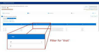
Figure 3. Filter the L3 products such as spectrometer orthorectified surface directional reflectance – mosaic (DP3.30006.001) to ‘Visit’ to filter L3 mosaic files

Please contact us if you have any additional questions regarding the data or to access the field spectroscopy data.

Share

Related Posts:

AOP Data Availability Notification – Release 2025

January 10, 2025

NEON Remote Sensing Data Available on Google Earth Engine

September 16, 2024

Monitoring Disaster Recovery From the Air with NEON

August 22, 2024

Boulder Flatiron smoke
NSF NEON, Operated by Battelle

Follow Us:

Join Our Newsletter

Get updates on events, opportunities, and how NEON is being used today.

Subscribe Now

Footer

  • About Us
  • Newsroom
  • Contact Us
  • Terms & Conditions
  • Careers
  • Code of Conduct

Copyright © Battelle, 2025

The National Ecological Observatory Network is a major facility fully funded by the U.S. National Science Foundation.

Any opinions, findings and conclusions or recommendations expressed in this material do not necessarily reflect the views of the U.S. National Science Foundation.