NSF NEON | Open Data to Understand our Ecosystems logo
Sign In

Main navigation

  • About Us
    • Overview
      • Spatial and Temporal Design
      • History
    • Management
    • Advisory Groups
      • Advisory Committee: STEAC
      • Technical Working Groups (TWGs)
    • FAQ
    • Contact Us
      • Field Offices
    • User Accounts
    • Staff

    About Us

  • Data & Samples
    • Data Portal
      • Explore Data Products
      • Data Availability Charts
      • Spatial Data & Maps
      • Document Library
      • API & GraphQL
      • Prototype Data
      • External Lab Data Ingest (restricted)
    • Samples & Specimens
      • Discover and Use NEON Samples
        • Sample Types
        • Sample Repositories
        • Sample Explorer
        • Megapit and Distributed Initial Characterization Soil Archives
        • Excess Samples
      • Sample Processing
      • Sample Quality
      • Taxonomic Lists
    • Collection Methods
      • Protocols & Standardized Methods
      • AIrborne Remote Sensing
        • Flight Box Design
        • Flight Schedules and Coverage
        • Daily Flight Reports
        • Camera
        • Imaging Spectrometer
        • Lidar
      • Automated Instruments
        • Site Level Sampling Design
        • Sensor Collection Frequency
        • Instrumented Collection Types
          • Meteorology
          • Phenocams
          • Soil Sensors
          • Ground Water
          • Surface Water
      • Observational Sampling
        • Site Level Sampling Design
        • Sampling Schedules
        • Observation Types
          • Aquatic Organisms
            • Aquatic Microbes
            • Fish
            • Macroinvertebrates & Zooplankton
            • Periphyton, Phytoplankton, and Aquatic Plants
          • Terrestrial Organisms
            • Birds
            • Ground Beetles
            • Mosquitoes
            • Small Mammals
            • Soil Microbes
            • Terrestrial Plants
            • Ticks
          • Hydrology & Geomorphology
            • Discharge
            • Geomorphology
          • Biogeochemistry
          • DNA Sequences
          • Pathogens
          • Sediments
          • Soils
            • Soil Descriptions
    • Data Notifications
    • Data Guidelines and Policies
      • Acknowledging and Citing NEON
      • Publishing Research Outputs
      • Usage Policies
    • Data Management
      • Data Availability
      • Data Formats and Conventions
      • Data Processing
      • Data Quality
      • Data Product Revisions and Releases
        • Release 2021
        • Release 2022
      • Externally Hosted Data

    Data & Samples

  • Field Sites
    • About Field Sites and Domains
    • Explore Field Sites
    • Site Management Data Product

    Field Sites

  • Impact
    • Observatory Blog
    • Case Studies
    • Spotlights
    • Papers & Publications
    • Newsroom
      • NEON in the News
      • Newsletter Archive

    Impact

  • Resources
    • Getting Started with NEON Data & Resources
    • Documents and Communication Resources
      • Papers & Publications
      • Document Library
      • Outreach Materials
    • Code Hub
      • Code Resources Guidelines
      • Code Resources Submission
      • NEON's GitHub Organization Homepage
    • Learning Hub
      • Science Videos
      • Tutorials
      • Workshops & Courses
      • Teaching Modules
      • Faculty Mentoring Networks
      • Data Education Fellows
    • Research Support and Assignable Assets
      • Field Site Coordination
      • Letters of Support
      • Mobile Deployment Platforms
      • Permits and Permissions
      • AOP Flight Campaigns
      • Excess Samples
      • Assignable Assets FAQs
    • Funding Opportunities

    Resources

  • Get Involved
    • Advisory Groups
    • Upcoming Events
    • Past Events
    • NEON Ambassador Program
    • Collaborative Works
      • EFI-NEON Ecological Forecasting Challenge
      • NCAR-NEON-Community Collaborations
    • Community Engagement
    • Work Opportunities
      • Careers
      • Seasonal Fieldwork
      • Postdoctoral Fellows
      • Internships
        • Intern Alumni
    • Partners

    Get Involved

  • My Account
  • Search

Search

Field Sites

  • About Field Sites and Domains
  • Explore Field Sites
  • Site Management Data Product

Breadcrumb

  1. Field Sites
  2. Central Plains Experimental Range NEON

Field Site

Central Plains Experimental Range NEON / CPER

brown square white mountain icon

Core Terrestrial, CO, D10: Central Plains

CPER field site with tower

About Field Sites

The Central Plains Experimental Range (CPER) is a terrestrial NEON field site located in Weld County on the Western boundary of the Pawnee National Grasslands in Colorado. This 65.4 km2 (16,160 acre) site is 120 km (75.5 mi.) north of Denver with an elevation around 1600 m (5249 ft.). The land is managed by the U.S. Department of Agriculture's Agricultural Research Service. CPER is part of NEON's Central Plains Domain (D10). D10 has two other terrestrial field sites and one aquatic field site. CPER is not colocated with an aquatic site. [1]

Climate

The Central Plains region is known for dry, hot summers and cold winters. Weather can change drastically in a short period of time. The combination of high elevation and mountain ranges are what mainly drives this region’s climate. At the NEON site at CPER the mean annual temperature is 8.6°C (47.5°F) and the mean annual precipitation is 344.2 mm (13.6 in.). The area can be subject to tornados, flooding, blizzards, and severe winter storms. [3] [4] [5]

Geology

The major geologic formation at the Central Plains Experimental Range is the Laramie formation, containing shales and claystone with minor sandstone lenses. [2]

Soils

The soil subgroup found at CPER is aridic argiustolls. The major soil series on the site include Vona, Ascalon, Renohill, Terry, Haverson, Nunn, Cascajo, Avar, Olney, Tassel, Playas, Shingle, Manter, and Bankard. [10]

Hydrology

Open water only makes up 0.01 km2 (2.5 acres) or 0.02% of the total land cover at NEON's CPER site. The land is dominated by herbaceous grasslands which covers 62.67 km2 (15,486 acres) or 98.5% of the total land cover at the site. [1]

Vegetation

The dominant vegetation at CPER is moderately grazed shortgrass steppe. Dominant plant species include blue grama (Bouteloua gracilis), buffalograss (Bouteloua dactyloides), and plains prickly-pear cactus (Opuntia polyacantha). [1]

Fauna

The Pawnee National Grasslands is a unique ecosystem. Birds including the Colorado state bird the lark bunting (Calamospiza melanocorys), mountain plover (Charadrius montanus), burrowing owl (Athene cunicularia), and various birds of prey can be found in the area. Mammals including the proghorn (Antilocapra americana), mule deer (Odocoileus hemionus), coyote (Canis latrans), and swift fox (Vulpes velox) are also commonly found in the great plains of Colorado. AT CPER, NEON collects data on beetles, mosquitoes, ticks, birds, and small mammals. [1] [7]

Past Land Management and Use

CPER has a long history of research. Grazing and soil erosion studies that started in the 1930s are still underway. CPER served as part of the of the Shortgrass Steppe LTER from 1982-2014. Cattle and burrowing animals such as the black-tailed prairie dog (Cynomys ludovicianus) play dominant roles in ecosystem function and maintenance. NEON TOS Plots were allocated across the site following NEON standard criteria and to avoid existing research. [1] [8]

Current Land Management and Use

The land is managed by the Agricultural Research Service (ARS) under the U.S. Department of Agriculture. The mission of the ARS is to study agricultural issues in the U.S. ARS is active in the science community - it participates in 600 research projects within 15 national programs and conducts research at over 90 research locations, including work outside of the U.S. [9]

NEON Site Establishment

Plots were established at NEON's CPER site in December 2014. In March 2014 the site went under a sampling readiness review. TOS sampling began at the site in October 2014. The TIS tower also was completed in 2014 and began collecting data that year.

Additional Resources

[1] Terrestrial Observation System (TOS) Site Characterization Report: Domain 10. NEON.DOC.003883vB

[2] U.S. Geological Survey, 2005, Mineral Resources Data System: U.S. Geological Survey, Reston, Virginia. https://mrdata.usgs.gov/mrds/

[3 PRISM Climate Group, Oregon State University, http://prism.oregonstate.edu, created 4 Feb 2004

[4] https://climate.colostate.edu/climate_long.html

[5]https://www.weldgov.com/departments/office_of_ emergency_management/history_of_weld_county_disasters

[6] Hazlett, Donald L. 1998. Vascular Plant Species of The Pawnee National Grassland. General Technical Report RMRS-GTR -17. Fort Collins, CO: U.S. Department of Agriculture, Forest Service, Rocky Mountain Research Station, 26 p.

[7] https://www.fs.usda.gov/detail/arp/learning/?cid=fsm91_058299

[8] Central Plains Experimental Range, 2017. United States Department of Agriculture: Rangeland Resources and Systems Research . Retrieved from: https://www.ars.usda.gov/plains -area/fort-collins-co/center-for-agricultural- resources-research/rangeland-resources-systems -research/docs/rrsr/central-plains-experimental- research-location/

[9] https://www.ars.usda.gov/about-ars/

[10] Steinert, Andy. (2016). NEON Site-Level Plot Summary: Central Plains Experimental Range (CPER), August 2016.

https://data.neonscience.org/documents/10179/2361410/CPER_Soil_SiteSumm…

Field Site Information

Latitude/Longitude

40.815536, -104.74559

Geodetic Datum

WGS84

Location

Weld County
CO, US

Elevation

Mean: 1654m
Minimum: 1601m
Maximum: 1686m

Mean Annual Temperature

8.6°C

Mean Annual Precipitation

344mm

Dominant Wind Direction

NW

Mean Canopy Height

0.4m

Dominant NLCD Classes

Grassland/Herbaceous

Colocated Site(s)

Co-Located Research

USDA Agricultural Research Service Central Plains Research Center
Pawnee National Atmospheric Deposition Program
Critical Zone Exploration Network
Ameriflux
NOAA U.S. Climate Reference Network

Field Operations Office

1685 38th Street, Suite 100
Boulder, CO 80301

Research Access

Non-NEON research activities are allowed in this area. Researchers must obtain their own permits with the site host(s).

Request Access

Observation Types

Remote Sensing

Remote sensing surveys of this field site collect lidar, spectrometer and high-resolution RGB camera data.

Meteorological Measurements

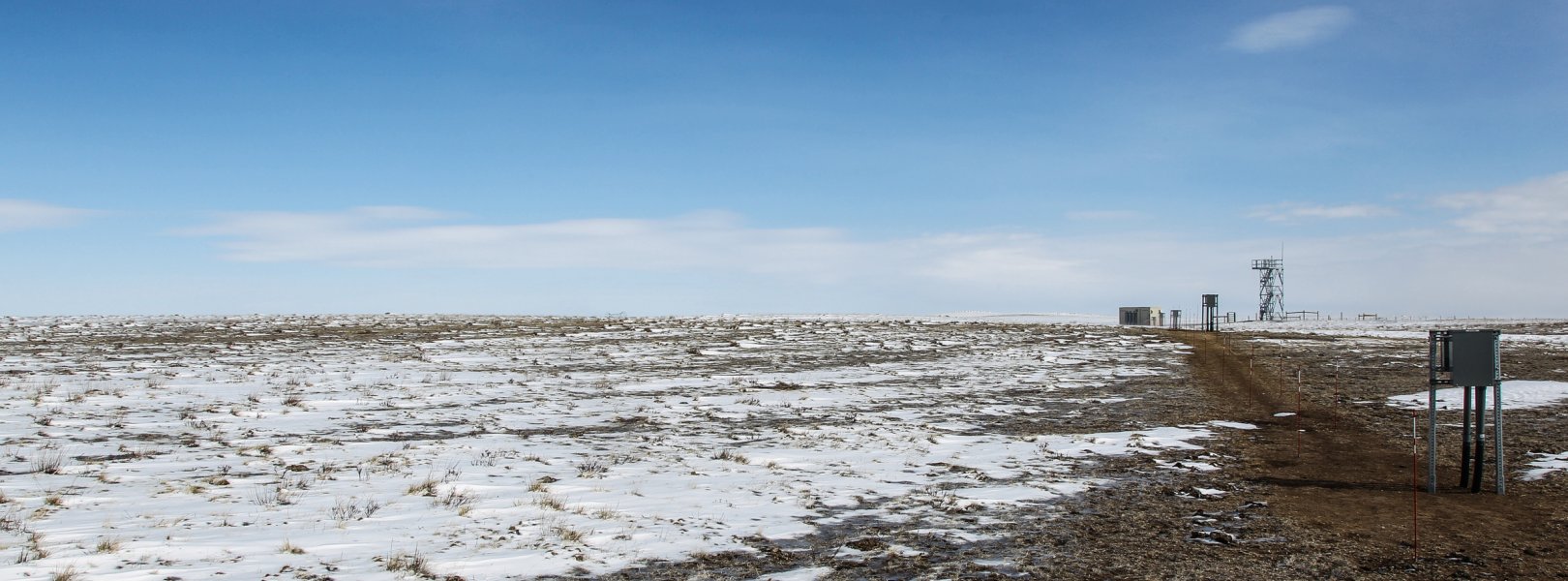
This site has a flux/meteorological tower that is 8 m (26 ft) tall with four measurement levels. The tower top extends above the vegetation canopy to allow sensors mounted at the top and along the tower to capture the full profile of atmospheric conditions from the top of the vegetation canopy to the ground. The tower collects physical and chemical properties of atmosphere-related processes, such as humidity, wind, and net ecosystem gas exchange. Precipitation data may be collected by a tipping bucket at the top of the tower, a Double Fence Intercomparison Reference (DFIR) near the tower.

Phenocams

Tower top|Tower bottom

Soil Sensor Measurements

This site has five soil plots placed in an array within the airshed of the flux tower. Photosynthetically Active Radiation (PAR) at soil surface, soil heat flux, solar radiation, and throughfall are measured at the soil surface in each soil plot. Soil moisture, soil temperature, and CO2 concentration are measured at multiple depths in each soil plot.

Observational Sampling

At terrestrial sites, field ecologists observe birds and plants, and sample ground beetles, mosquitoes, small mammals, soil microbes, and ticks. Lab analyses are carried out to provide further data on DNA sequences, pathogens, soils, sediments, and biogeochemistry. Learn more about terrestrial observations or explore this site's data products.


Field Site Data

Site

Site Host

USDA-Agricultural Research Service

Site Access Allowed

Yes

Site URL

https://www.ars.usda.gov/plains-area/fort-collins-co/center-for-agricultural-resources-research/rangeland-resources-systems-research/docs/rrsr/central-plains-experimental-research-location/

Site Access Details

Reseachers should coordinate with the site manager.

Operations Office

NEON Field Operations Office

Domain 10/13 Support Facility

NEON Field Operations Address

1685 38th Street, Suite 100
Boulder, CO 80301

NEON Field Operations Phone

720.836.2439

Location

Latitude

40.815536

Longitude

-104.74559

Geodetic Datum

WGS84

UTM Northing

4518311.06m

UTM Easting

521454.77m

UTM Zone

13N

County

Weld

State

CO

Country

US

Mean Elevation

1654m

Minimum Elevation

1601m

Maximum Elevation

1686m

Climate

Mean Annual Temperature

8.6°C

Mean Annual Precipitation

344mm

Dominant Wind Direction

NW

Vegetation

Mean Canopy Height

0.4m

Dominant NLCD Classes

Grassland/Herbaceous

Average number of green days

260

Average first greenness increase date

90 DOY

Average peak green date

165 DOY

Average first greenness decrease date

210 DOY

Average minimum greenness date

350 DOY

Tower

Tower Height

9m

Number of Tower Levels

4

Geology

USGS Geology Unit

COKl;0

USGS Geology Name

Laramie Formation

USGS Lithologic Constituents

Shale, claystone, and sandstone with some coal

USGS Geology Age

Cretaceous

Soils

Megapit Soil Family

Fine, loamy, mixed, superactive, mesic. Aridic Argiustolls.

Soil Subgroup

Aridic Argiustolls


Gallery

  • Photos
  • Videos

No Video


Related Field Sites

Other Domain D10 Field Sites

blue square white drop icon Arikaree River NEON
Core Aquatic
brown circle white drop icon North Sterling NEON
Gradient Terrestrial
brown circle white drop icon Rocky Mountains NEON
Gradient Terrestrial

Other Field Sites in CO

blue square white drop icon Arikaree River NEON
Core Aquatic
blue square white drop icon Como Creek NEON
Core Aquatic
brown square white mountain icon Niwot Ridge NEON
Core Terrestrial
brown circle white drop icon North Sterling NEON
Gradient Terrestrial
brown circle white drop icon Rocky Mountains NEON
Gradient Terrestrial
blue circle white drop icon West St Louis Creek NEON
Gradient Aquatic
NEON Logo

Follow Us:

Join Our Newsletter

Get updates on events, opportunities, and how NEON is being used today.

Subscribe Now

Footer

  • My Account
  • About Us
  • Newsroom
  • Contact Us
  • Terms & Conditions
  • Careers

Copyright © Battelle, 2019-2020

The National Ecological Observatory Network is a major facility fully funded by the National Science Foundation.

Any opinions, findings and conclusions or recommendations expressed in this material do not necessarily reflect the views of the National Science Foundation.