NSF NEON, Operated by Battelle

Main navigation

  • About Us
    • Overview
      • Spatial and Temporal Design
      • History
    • Vision and Management
    • Advisory Groups
      • Science, Technology & Education Advisory Committee
      • Technical Working Groups (TWGs)
    • FAQ
    • Contact Us
      • Contact NEON Biorepository
      • Field Offices
    • User Accounts
    • Staff
    • Code of Conduct

    About Us

  • Data & Samples
    • Data Portal
      • Explore Data Products
      • Data Availability Charts
      • Spatial Data & Maps
      • Document Library
      • API & GraphQL
      • Prototype Data
      • External Lab Data Ingest (restricted)
    • Data Themes
      • Biogeochemistry
      • Ecohydrology
      • Land Cover and Processes
      • Organisms, Populations, and Communities
    • Samples & Specimens
      • Discover and Use NEON Samples
        • Sample Types
        • Sample Repositories
        • Sample Explorer
        • Megapit and Distributed Initial Characterization Soil Archives
      • Sample Processing
      • Sample Quality
      • Taxonomic Lists
    • Collection Methods
      • Protocols & Standardized Methods
      • Airborne Remote Sensing
        • Flight Box Design
        • Flight Schedules and Coverage
        • Daily Flight Reports
          • AOP Flight Report Sign Up
        • Camera
        • Imaging Spectrometer
        • Lidar
      • Automated Instruments
        • Site Level Sampling Design
        • Sensor Collection Frequency
        • Instrumented Collection Types
          • Meteorology
          • Phenocams
          • Soil Sensors
          • Ground Water
          • Surface Water
      • Observational Sampling
        • Site Level Sampling Design
        • Sampling Schedules
        • Observation Types
          • Aquatic Organisms
            • Aquatic Microbes
            • Fish
            • Macroinvertebrates & Zooplankton
            • Periphyton, Phytoplankton, and Aquatic Plants
          • Terrestrial Organisms
            • Birds
            • Ground Beetles
            • Mosquitoes
            • Small Mammals
            • Soil Microbes
            • Terrestrial Plants
            • Ticks
          • Hydrology & Geomorphology
            • Discharge
            • Geomorphology
          • Biogeochemistry
          • DNA Sequences
          • Pathogens
          • Sediments
          • Soils
            • Soil Descriptions
        • Optimizing the Observational Sampling Designs
    • Data Notifications
    • Data Guidelines and Policies
      • Acknowledging and Citing NEON
      • Publishing Research Outputs
      • Usage Policies
    • Data Management
      • Data Availability
      • Data Formats and Conventions
      • Data Processing
      • Data Quality
      • Data Product Bundles
      • Data Product Revisions and Releases
        • Release 2021
        • Release 2022
        • Release 2023
        • Release 2024
        • Release-2025
      • NEON and Google
      • Externally Hosted Data

    Data & Samples

  • Field Sites
    • About Field Sites and Domains
    • Explore Field Sites
    • Site Management Data Product

    Field Sites

  • Impact
    • Observatory Blog
    • Case Studies
    • Papers & Publications
    • Newsroom
      • NEON in the News
      • Newsletter Archive
      • Newsletter Sign Up

    Impact

  • Resources
    • Getting Started with NEON Data & Resources
    • Documents and Communication Resources
      • Papers & Publications
      • Document Library
      • Outreach Materials
    • Code Hub
      • Code Resources Guidelines
      • Code Resources Submission
      • NEON's GitHub Organization Homepage
    • Learning Hub
      • Science Videos
      • Tutorials
      • Workshops & Courses
      • Teaching Modules
    • Research Support Services
      • Field Site Coordination
      • Letters of Support
      • Mobile Deployment Platforms
      • Permits and Permissions
      • AOP Flight Campaigns
      • Research Support FAQs
      • Research Support Projects
    • Funding Opportunities

    Resources

  • Get Involved
    • Advisory Groups
      • Science, Technology & Education Advisory Committee
      • Technical Working Groups
    • Upcoming Events
    • NEON Ambassador Program
      • Exploring NEON-Derived Data Products Workshop Series
    • Research and Collaborations
      • Environmental Data Science Innovation and Inclusion Lab
      • Collaboration with DOE BER User Facilities and Programs
      • EFI-NEON Ecological Forecasting Challenge
      • NEON Great Lakes User Group
      • NEON Science Summit
      • NCAR-NEON-Community Collaborations
        • NCAR-NEON Community Steering Committee
    • Community Engagement
      • How Community Feedback Impacts NEON Operations
    • Science Seminars and Data Skills Webinars
      • Past Years
    • Work Opportunities
      • Careers
      • Seasonal Fieldwork
      • Internships
        • Intern Alumni
    • Partners

    Get Involved

  • My Account
  • Search

Search

Field Sites

  • About Field Sites and Domains
  • Explore Field Sites
  • Site Management Data Product

Breadcrumb

  1. Field Sites
  2. Lower Teakettle NEON

Field Site

Lower Teakettle NEON / TEAK

brown circle white drop icon

Gradient Terrestrial, CA, D17: Pacific Southwest

Forest and hills at Lower Teakettle terrestrial field site in California

About Field Sites

Lower Teakettle (TEAK) is a terrestrial NEON field site located in the Sierra National Forest, 80 km (50 mi.) east of Fresno, CA, near Courtright and Wishon Reservoirs. NEON samples 51.4 km2 (12,700 acres) at the site, which is managed by the U.S. Forest Service and partially encompasses the Pacific Southwest Research Station’s Teakettle Experimental Forest. It is a mixed conifer forest, ranging in elevation from 1900 - 2807 m (6230 - 9210 ft.). The varied terrain is typical of the Sierra Nevadas, with rugged mountains, meadows and prominent granite outcrops. TEAK is part of the Pacific Southwest Domain (D17), which is bounded by the Pacific Ocean on the west and the Sierra Nevada Mountains on the east, and encompasses most of California. There are four other NEON field sites in D17, including two additional terrestrial sites and two aquatic sites. TEAK is colocated with the aquatic site Teakettle 2 Creek (TECR). [1] [2]

Climate

Like most of the Sierra Nevada range, TEAK experiences hot, dry summers and mild, wet winters. It receives most of its annual precipitation as snowfall between November and May. Snow accumulation is highly variable, but has averaged a maximum depth of 1140 mm (45 in.) over the past 30 years. Mean annual temperature is 8°C (46°F). Mean annual precipitation is 1222.5 mm (48.1 in.). [2] [5]

Geology

The geology of TEAK is glacial deposits overlaying granitic rocks. [3]

Soils

Soils at TEAK are classified as coarse-loamy, mixed, superactive, frigid Pachic Humixerepts. [6]

Hydrology

TEAK is colocated with the aquatic site Teakettle Creek (TECR). The flow regime of TECR is typical of snowmelt-dominated mountainous streams in the west. Base flows are lowest in the winter (November - March) and highest in the late spring (April – June). TECR has a mean base flow of 11 liters per second in the autumn months. Snow melt begins in March and peaks in June. Discharge during the peak flow months of May and June is approximately 18 times greater than base flow. [4]

Vegetation

Dominant tree species include red and white fir (Abies magnifica and Abies concolor), Jeffrey pine (Pinus jeffreyi), and lodgepole pine (Pinus contorta). Stand structure is diverse, with active recruitment and extensive coarse downed wood. Although dense tree cover limits understory shrubs, bush chinquapin (Chrysolepis sempervirens) often grows on forested slopes. Exposed rock and shallow soils support other shrub species, such as mountain whitethorn (Ceanothus cordulatus), greenleaf manzanita (Arctostaphylos patula) and pinemat manzanita (Arctostaphylos nevadensis). Pine and fir forests provide habitat for more shade-tolerant herbaceous plants, whereas meadows, streams, and patches of shallow soil accommodate a greater diversity of native grasses, graminoids, and forbs. [1]

Past Land Management and Use

Before the area was primarily dedicated to research, it was subject to cattle grazing and fire suppression, but no timber harvesting. In the 1930s, state and federal government agencies began to research how the management of Sierra Nevada watersheds could impact the Central Valley of California's water supply. The Teakettle Experimental Area was established in 1938, when 13 km2 (3200 acres) in Teakettle Creek were designated for hydrological study. In the 1940s, stream-gauging stations and sediment basins were built in the study area. The area was officially designated “The Teakettle Creek Experimental Forest” in 1958. The main objectives of the forest were to develop timber harvesting techniques and patterns that would increase water yield. Throughout the 1970s, researchers used these stations to collect data on water flow and weather conditions. In the late 1990s, a large experiment involving over two dozen researchers started in the area. The experiment continues to run, examining the effects of fire and thinning on mixed-conifer ecosystems. [2] [7]

Current Land Management and Use

TEAK is managed by the U.S. Forest Service and partially encompasses the Pacific Southwest Research Station’s Teakettle Experimental Forest. The USFS manages the forest for grazing and research activities associated with the long-term "Teakettle Experiment," which started in the late 1990s and examines the effects of fire and thinning on ecosystem function. [1] [2] [7]

Additional Resources

[1] Terrestrial Observation System (TOS) Site Characterization Report: Domain 17. NEON.DOC.003900vB

[2] https://www.fs.fed.us/psw/ef/teakettle/

[3] U.S. Geological Survey, 2005, Mineral Resources Data System: U.S. Geological Survey, Reston, Virginia. https://mrdata.usgs.gov/mrds/

[4] Aquatic Instrument System (AIS) Site Characterization Report: Domain 17. NEON.DOC.003536vA.

[5] PRISM Climate Group., Oregon State University, http://prism.oregonstate.edu, created 4 Feb 2004.

[6] https://data.neonscience.org/megapit-details/tags/teak/

[7] https://www.fs.fed.us/psw/topics/water/kingsriver/location_teakettle.sh…

Field Site Information

Latitude/Longitude

37.00583, -119.00602

Geodetic Datum

WGS84

Location

Fresno County
CA, US

Elevation

Mean: 2149m
Minimum: 2086m
Maximum: 2734m

Mean Annual Temperature

8.0°C

Dominant Wind Direction

NW

Mean Canopy Height

35.0m

Dominant NLCD Classes

Evergreen Forest, Shrub/Scrub

Colocated Site(s)

Teakettle Creek - Watershed 2 NEON

Colocated Research

Teakettle Experimental Forest
Critical Zone Exploration Network
Ameriflux
Southern Sierra CZO

Field Operations Office

4727 West Shaw Avenue
Fresno, CA 93722

Research Access

Non-NEON research activities are allowed in this area. Researchers must obtain their own permits with the site host(s).

Request Access

Observation Types

Remote Sensing

Remote sensing surveys of this field site collect lidar, spectrometer and high-resolution RGB camera data.

Meteorological Measurements

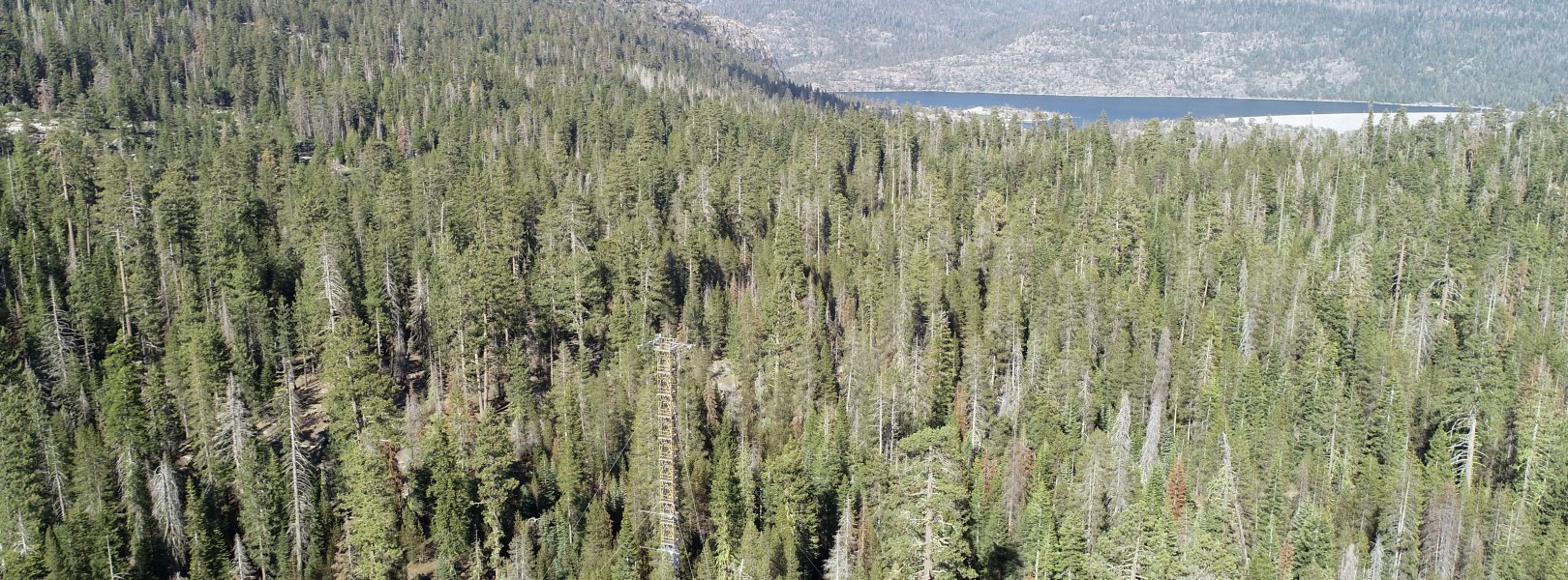
This site has a flux/meteorological tower that is 59 m (194 ft) tall with seven measurement levels. The tower top extends above the vegetation canopy to allow sensors mounted at the top and along the tower to capture the full profile of atmospheric conditions from the top of the vegetation canopy to the ground. The tower collects physical and chemical properties of atmosphere-related processes, such as humidity, wind, and net ecosystem gas exchange. Precipitation data are collected by a tipping bucket at the top of the tower and a series of throughfalls located in the soil array.

Phenocams

One phenocam is attached to the top and the bottom of the tower. Here we show the images from the most recent hour. The full collection of images can be viewed on the Phenocam Gallery - click on either of the images below.

Tower top

NEON.D17.TEAK.DP1.10033

Tower bottom

NEON.D17.TEAK.DP1.10042

Soil Sensor Measurements

This site has five soil plots placed in an array within the airshed of the flux tower. Photosynthetically Active Radiation (PAR) at soil surface, soil heat flux, solar radiation, and throughfall are measured at the soil surface in each soil plot. Soil moisture, soil temperature, and CO2 concentration are measured at multiple depths in each soil plot.

Observational Sampling

At terrestrial sites, field ecologists observe birds and plants, and sample ground beetles, mosquitoes, small mammals, soil microbes, and ticks. Lab analyses are carried out to provide further data on DNA sequences, pathogens, soils, sediments, and biogeochemistry. Learn more about terrestrial observations or explore this site's data products.


Field Site Data

Site

Site Host

US Forest Service

Site Access Allowed

Yes

Site URL

https://www.fs.usda.gov/sierra/

Site Access Details

Researchers should coordinate directly with the US Forest Service for permitting and approval.

Operations Office

NEON Field Operations Office

Domain 17 Support Facility

NEON Field Operations Address

4727 West Shaw Avenue
Fresno, CA 93722

NEON Field Operations Phone

559.396.4119

Location

Latitude

37.00583

Longitude

-119.00602

Geodetic Datum

WGS84

UTM Northing

4097400.18m

UTM Easting

321515.74m

UTM Zone

11N

County

Fresno

State

CA

Country

US

Mean Elevation

2149m

Minimum Elevation

2086m

Maximum Elevation

2734m

Climate

Mean Annual Temperature

8.0°C

Mean Annual Precipitation

1223mm

Dominant Wind Direction

NW

Vegetation

Mean Canopy Height

35.0m

Dominant NLCD Classes

Evergreen Forest, Shrub/Scrub

Average number of green days

180

Average first greenness increase date

120 DOY

Average peak green date

180 DOY

Average first greenness decrease date

205 DOY

Average minimum greenness date

300 DOY

Tower

Tower Height

59m

Number of Tower Levels

7

Soils

Megapit Soil Family

Coarse-loamy - mixed - superactive - frigid Pachic Humixerepts

Soil Subgroup

Pachic Humixerepts


Gallery

  • Photos
  • Videos

Related Field Sites

Other Domain D17 Field Sites

brown square white mountain icon San Joaquin Experimental Range NEON
Core Terrestrial
brown circle white drop icon Soaproot Saddle NEON
Gradient Terrestrial
blue square white drop icon Teakettle Creek - Watershed 2 NEON
Core Aquatic
blue circle white drop icon Upper Big Creek NEON
Gradient Aquatic

Other Field Sites in CA

brown square white mountain icon San Joaquin Experimental Range NEON
Core Terrestrial
brown circle white drop icon Soaproot Saddle NEON
Gradient Terrestrial
blue square white drop icon Teakettle Creek - Watershed 2 NEON
Core Aquatic
blue circle white drop icon Upper Big Creek NEON
Gradient Aquatic
NSF NEON, Operated by Battelle

Follow Us:

Join Our Newsletter

Get updates on events, opportunities, and how NEON is being used today.

Subscribe Now

Footer

  • About Us
  • Newsroom
  • Contact Us
  • Terms & Conditions
  • Careers
  • Code of Conduct

Copyright © Battelle, 2025

The National Ecological Observatory Network is a major facility fully funded by the U.S. National Science Foundation.

Any opinions, findings and conclusions or recommendations expressed in this material do not necessarily reflect the views of the U.S. National Science Foundation.