NSF NEON, Operated by Battelle

Main navigation

  • About Us
    • Overview
      • Spatial and Temporal Design
      • History
    • Vision and Management
    • Advisory Groups
      • Science, Technology & Education Advisory Committee
      • Technical Working Groups (TWGs)
    • FAQ
    • Contact Us
      • Contact NEON Biorepository
      • Field Offices
    • User Accounts
    • Staff
    • Code of Conduct

    About Us

  • Data & Samples
    • Data Portal
      • Explore Data Products
      • Data Availability Charts
      • Spatial Data & Maps
      • Document Library
      • API & GraphQL
      • Prototype Data
      • External Lab Data Ingest (restricted)
    • Data Themes
      • Biogeochemistry
      • Ecohydrology
      • Land Cover and Processes
      • Organisms, Populations, and Communities
    • Samples & Specimens
      • Discover and Use NEON Samples
        • Sample Types
        • Sample Repositories
        • Sample Explorer
        • Megapit and Distributed Initial Characterization Soil Archives
      • Sample Processing
      • Sample Quality
      • Taxonomic Lists
    • Collection Methods
      • Protocols & Standardized Methods
      • Airborne Remote Sensing
        • Flight Box Design
        • Flight Schedules and Coverage
        • Daily Flight Reports
          • AOP Flight Report Sign Up
        • Camera
        • Imaging Spectrometer
        • Lidar
      • Automated Instruments
        • Site Level Sampling Design
        • Sensor Collection Frequency
        • Instrumented Collection Types
          • Meteorology
          • Phenocams
          • Soil Sensors
          • Ground Water
          • Surface Water
      • Observational Sampling
        • Site Level Sampling Design
        • Sampling Schedules
        • Observation Types
          • Aquatic Organisms
            • Aquatic Microbes
            • Fish
            • Macroinvertebrates & Zooplankton
            • Periphyton, Phytoplankton, and Aquatic Plants
          • Terrestrial Organisms
            • Birds
            • Ground Beetles
            • Mosquitoes
            • Small Mammals
            • Soil Microbes
            • Terrestrial Plants
            • Ticks
          • Hydrology & Geomorphology
            • Discharge
            • Geomorphology
          • Biogeochemistry
          • DNA Sequences
          • Pathogens
          • Sediments
          • Soils
            • Soil Descriptions
        • Optimizing the Observational Sampling Designs
    • Data Notifications
    • Data Guidelines and Policies
      • Acknowledging and Citing NEON
      • Publishing Research Outputs
      • Usage Policies
    • Data Management
      • Data Availability
      • Data Formats and Conventions
      • Data Processing
      • Data Quality
      • Data Product Bundles
      • Data Product Revisions and Releases
        • Release 2021
        • Release 2022
        • Release 2023
        • Release 2024
        • Release-2025
      • NEON and Google
      • Externally Hosted Data

    Data & Samples

  • Field Sites
    • About Field Sites and Domains
    • Explore Field Sites
    • Site Management Data Product

    Field Sites

  • Impact
    • Observatory Blog
    • Case Studies
    • Papers & Publications
    • Newsroom
      • NEON in the News
      • Newsletter Archive
      • Newsletter Sign Up

    Impact

  • Resources
    • Getting Started with NEON Data & Resources
    • Documents and Communication Resources
      • Papers & Publications
      • Document Library
      • Outreach Materials
    • Code Hub
      • Code Resources Guidelines
      • Code Resources Submission
      • NEON's GitHub Organization Homepage
    • Learning Hub
      • Science Videos
      • Tutorials
      • Workshops & Courses
      • Teaching Modules
    • Research Support Services
      • Field Site Coordination
      • Letters of Support
      • Mobile Deployment Platforms
      • Permits and Permissions
      • AOP Flight Campaigns
      • Research Support FAQs
      • Research Support Projects
    • Funding Opportunities

    Resources

  • Get Involved
    • Advisory Groups
      • Science, Technology & Education Advisory Committee
      • Technical Working Groups
    • Upcoming Events
    • NEON Ambassador Program
      • Exploring NEON-Derived Data Products Workshop Series
    • Research and Collaborations
      • Environmental Data Science Innovation and Inclusion Lab
      • Collaboration with DOE BER User Facilities and Programs
      • EFI-NEON Ecological Forecasting Challenge
      • NEON Great Lakes User Group
      • NEON Science Summit
      • NCAR-NEON-Community Collaborations
        • NCAR-NEON Community Steering Committee
    • Community Engagement
      • How Community Feedback Impacts NEON Operations
    • Science Seminars and Data Skills Webinars
      • Past Years
    • Work Opportunities
      • Careers
      • Seasonal Fieldwork
      • Internships
        • Intern Alumni
    • Partners

    Get Involved

  • My Account
  • Search

Search

Field Sites

  • About Field Sites and Domains
  • Explore Field Sites
  • Site Management Data Product

Breadcrumb

  1. Field Sites
  2. Niwot Ridge NEON

Field Site

Niwot Ridge NEON / NIWO

brown square white mountain icon

Core Terrestrial, CO, D13: Southern Rockies & Colorado Plateau

Niwot Ridge (NIWO) tower in the autumn

About Field Sites

The Niwot Ridge Mountain Research Station (NIWO) is a terrestrial site within the Front Range of the Rocky Mountains, 27 km (16.8 mi.) west of Boulder, Colorado and 6 km (3.7 mi.) east of the Continental Divide. NEON collects data over 13.4 km2 (3311 acres) at the site, which is on land managed by the University of Colorado in Boulder and the U.S. Forest Service. Sitting at 3000-3600 m (9843-11810 ft.) in elevation, this site's climate and biota are representative of the diverse landscapes of the Southern Rocky Mountains. Diverse gradients allow NEON to challenge questions surrounding land use change, climate impacts, and disturbance processes at multiple elevations. NIWO is part of NEON's Southern Rockies and Colorado Plateau Domain (D13). D13 includes one other terrestrial site and two aquatic sites. NIWO is located near the COMO aquatic site. [1]

Climate

NIWO is located in the Southern Rockies, which, due to elevational changes, have a climate characterized by dramatic differences in precipitation and temperature over very short distances. In general, precipitation decreases and temperature increases with a decrease in elevation. NIWO ranges through several elevation gradients, creating diverse climates across the region. It is considered an alpine tundra ecosystem. Mean annual temperature is 0.3°C (32.5°F) with the majority the of the mean annual 1005 mm (39.5 in.) of precipitation being snow at the highest elevations. Snow is brought from the east by cyclonic easterly upslope flows of air at the lower elevations. Spring storms often occur during the afternoons. Fall is the driest season in this region with the lowest average precipitation recorded. At the lower elevations there are many distinct microclimates within the saddles, knolls, moraines, and other glacial features. [2] [4] [7]

Geology

The geology at Niwot Ridge consists of schist, migmatite, and biotitic gneiss. [5]

Soils

The dominate soil order found at NIWO are Mollisols. Overall, soil can be described as Coarse-loamy - mixed - superactive Typic Haplocryolls. [1]

Hydrology

NIWO is located within the Rocky Mountains, which are covered in snowmelt-fed springs and upland catchments which deliver water to downstream basins. Boulder receives most of its drinking water from these basins. [6]

Vegetation

Flora varies along an elevation gradient at NIWO. On the low-elevation east and south facing slopes, lodgepole pine (Pinus contorta) and aspen (Populus tremuloides) groves dominate the landscape. The transition zone between the closed subalpine forest and alpine tundra are full of meadows interspersed with stunted patches of coniferous trees. The alpine tundra sits above the treeline and is dominated by herbaceous plants such as Ross’ avens (Geum rossii) and curly sedge (Carex rupestris). The steepest, highest regions of NIWO are dominated by microplants and scree.

Fauna

The Rockies have many diverse animal species that call them home including Black bear (Ursus americanus), snowshoe hare (Lepus americanus), porcupine (Erithizon dorsatum) and elk (Cervus danadensis). Niwot ridge has both seasonal and year round residents such as the white-tailed ptarmigan (Lagopus leucura) and is host to 31 species of mammals. NEON collects fauna data on small mammals, birds, ticks, mosquitoes, and ground beetles. Commonly sampled species at NIWO are deer mice (Peromyscus maniculatus), redbacked voles (Myodes gapperi), and the ground beetle Pterostichus surgens. [1] [2]

Past Land Management and Use

The area has experienced multiple ecological disturbances throughout history, including stand-replacing fires, episodic insect outbreaks, and occasional wind damage. In the early 1900s the logging industry clear cut the forest. The area is encompassed within Niwot Ridge, which was established as a site in the NSF-sponsored Long Term Ecological Research (LTER) Program in 1980. [8]

Current Land Management and Use

NIWO is hosted by and operated under the Forest Service and the University of Colorado-Boulder (CU Boulder). The Mountain Research Station (MRS) at Niwot Ridge is an interdisciplinary research facility of the Institute of Arctic and Alpine Research at CU Boulder, which facilitates research to understand mountain ecosystems and advance education. Within this station, research is conducted via several organizations sponsored by the National Science Foundation including the Niwot Ridge LTER, Boulder Creek Critical Zone Program, and the NEON program. The MRS program was established at its current site in 1920 on property leased by the U.S. Forest Service. Research themes at Niwot Ridge include the movement of energy and nutrients across the subalpine-alpine landscape, the influence of nitrogen deposition on ecosystems and hydrology, and the influence of climate on diversity and ecosystem function. [1] [3] [9]

NEON Site Establishment

Characterization of NIWO began in May 2015. Terrestrial sampling readiness reviews were completed and initial site sampling began in August of that year. Tower establishment was completed and TIS became operational in April 2017.

Additional Resources

[1] Terrestrial Observation System (TOS) Site Characterization Report: Domain 13. NEON.DOC.003896vB

[2] Greenland, David 1989. The Climate of Niwot Ridge, Front Range,Colorado, U.S.A.

[3] https://www.colorado.edu/mrs/general-info/mission-history

[4] PRISM Climate Group, Oregon State University, http://prism.oregonstate.edu, created 4 Feb 2004.

[5] U.S. Geological Survey, 2005, Mineral Resources Data System: U.S. Geological Survey, Reston, Virginia. https://mrdata.usgs.gov/mrds/

[6] Fields, Jordan F.; Dethier, David P. 2019 From on high: Geochemistry of alpine springs, Niwot Ridge, Colorado Front Range, USA

[7] https://climate.colostate.edu/climate_long.html

[8] https://www.nrs.fs.fed.us/data/lcms/niwot/

[9] https://www.colorado.edu/mrs/general-info

Field Site Information

Latitude/Longitude

40.05425, -105.58237

Geodetic Datum

WGS84

Location

Boulder County
CO, US

Elevation

Mean: 3490m
Minimum: 2975m
Maximum: 3583m

Mean Annual Temperature

0.3°C

Dominant Wind Direction

WNW

Mean Canopy Height

0.2m

Dominant NLCD Classes

Evergreen Forest, Grassland/Herbaceous

Colocated Site(s)

Como Creek NEON

Colocated Research

Boulder Creek CZO
Niwot Saddle National Atmospheric Deposition Program
Critical Zone Exploration Network
University of Colorado
Ameriflux
NOAA Earth System Research Laboratories Global Monitoring Laboratory
NOAA U.S. Climate Reference Network

Field Operations Office

1685 38th Street, Suite 100
Boulder, CO 80301

Research Access

Non-NEON research activities are allowed in this area. Researchers must obtain their own permits with the site host(s).

Request Access

Observation Types

Remote Sensing

Remote sensing surveys of this field site collect lidar, spectrometer and high-resolution RGB camera data.

Meteorological Measurements

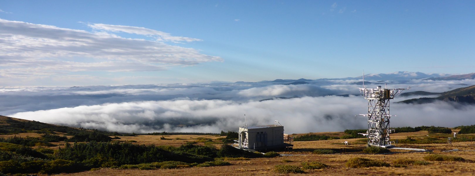
This site has a flux/meteorological tower that is 8 m (26 ft) tall with four measurement levels. The tower top extends above the vegetation canopy to allow sensors mounted at the top and along the tower to capture the full profile of atmospheric conditions from the top of the vegetation canopy to the ground. The tower collects physical and chemical properties of atmosphere-related processes, such as humidity, wind, and net ecosystem gas exchange. Precipitation data may be collected by a tipping bucket at the top of the tower, and a Double Fence Intercomparison Reference (DFIR) near the tower.

Phenocams

One phenocam is attached to the top and the bottom of the tower. Here we show the images from the most recent hour. The full collection of images can be viewed on the Phenocam Gallery - click on either of the images below.

Tower top

NEON.D13.NIWO.DP1.10033

Tower bottom

NEON.D13.NIWO.DP1.10042

Soil Sensor Measurements

This site has five soil plots placed in an array within the airshed of the flux tower. Photosynthetically Active Radiation (PAR) at soil surface, soil heat flux, and solar radiation are measured at the soil surface in each soil plot. Soil moisture, soil temperature, and CO2 concentration are measured at multiple depths in each soil plot.

Observational Sampling

At terrestrial sites, field ecologists observe birds and plants, and sample ground beetles, mosquitoes, small mammals, soil microbes, and ticks. Lab analyses are carried out to provide further data on DNA sequences, pathogens, soils, sediments, and biogeochemistry. Learn more about terrestrial observations or explore this site's data products.


Field Site Data

Site

Site Host

US Forest Service, University of Colorado-Boulder

Site Access Allowed

Yes

Site Access Details

Reseachers should coordinate with the site manager and submit a site research permit.

Operations Office

NEON Field Operations Office

Domain 10/13 Support Facility

NEON Field Operations Address

1685 38th Street, Suite 100
Boulder, CO 80301

NEON Field Operations Phone

720.836.2439

Location

Latitude

40.05425

Longitude

-105.58237

Geodetic Datum

WGS84

UTM Northing

4433940.92m

UTM Easting

450328.28m

UTM Zone

13N

County

Boulder

State

CO

Country

US

Mean Elevation

3490m

Minimum Elevation

2975m

Maximum Elevation

3583m

Climate

Mean Annual Temperature

0.3°C

Mean Annual Precipitation

1005mm

Dominant Wind Direction

WNW

Vegetation

Mean Canopy Height

0.2m

Dominant NLCD Classes

Evergreen Forest, Grassland/Herbaceous

Average number of green days

130

Average first greenness increase date

140 DOY

Average peak green date

190 DOY

Average first greenness decrease date

220 DOY

Average minimum greenness date

270 DOY

Tower

Tower Height

8m

Number of Tower Levels

4

Soils

Megapit Soil Family

Coarse-loamy - mixed - superactive Typic Haplocryolls

Soil Subgroup

Typic Haplocryolls


Gallery

  • Photos
  • Videos

No Video


Related Field Sites

Other Domain D13 Field Sites

blue square white drop icon Como Creek NEON
Core Aquatic
brown circle white drop icon Moab NEON
Gradient Terrestrial
blue circle white drop icon West St Louis Creek NEON
Gradient Aquatic

Other Field Sites in CO

blue square white drop icon Arikaree River NEON
Core Aquatic
brown square white mountain icon Central Plains Experimental Range NEON
Core Terrestrial
blue square white drop icon Como Creek NEON
Core Aquatic
brown circle white drop icon North Sterling NEON
Gradient Terrestrial
brown circle white drop icon Rocky Mountains NEON
Gradient Terrestrial
blue circle white drop icon West St Louis Creek NEON
Gradient Aquatic
NSF NEON, Operated by Battelle

Follow Us:

Join Our Newsletter

Get updates on events, opportunities, and how NEON is being used today.

Subscribe Now

Footer

  • About Us
  • Newsroom
  • Contact Us
  • Terms & Conditions
  • Careers
  • Code of Conduct

Copyright © Battelle, 2025

The National Ecological Observatory Network is a major facility fully funded by the U.S. National Science Foundation.

Any opinions, findings and conclusions or recommendations expressed in this material do not necessarily reflect the views of the U.S. National Science Foundation.