NSF NEON, Operated by Battelle

Main navigation

  • About Us
    • Overview
      • Spatial and Temporal Design
      • History
    • Vision and Management
    • Advisory Groups
      • Science, Technology & Education Advisory Committee
      • Technical Working Groups (TWGs)
    • FAQ
    • Contact Us
      • Contact NEON Biorepository
      • Field Offices
    • User Accounts
    • Staff
    • Code of Conduct

    About Us

  • Data & Samples
    • Data Portal
      • Explore Data Products
      • Data Availability Charts
      • Spatial Data & Maps
      • Document Library
      • API & GraphQL
      • Prototype Data
      • External Lab Data Ingest (restricted)
    • Data Themes
      • Biogeochemistry
      • Ecohydrology
      • Land Cover and Processes
      • Organisms, Populations, and Communities
    • Samples & Specimens
      • Discover and Use NEON Samples
        • Sample Types
        • Sample Repositories
        • Sample Explorer
        • Megapit and Distributed Initial Characterization Soil Archives
      • Sample Processing
      • Sample Quality
      • Taxonomic Lists
    • Collection Methods
      • Protocols & Standardized Methods
      • Airborne Remote Sensing
        • Flight Box Design
        • Flight Schedules and Coverage
        • Daily Flight Reports
          • AOP Flight Report Sign Up
        • Camera
        • Imaging Spectrometer
        • Lidar
      • Automated Instruments
        • Site Level Sampling Design
        • Sensor Collection Frequency
        • Instrumented Collection Types
          • Meteorology
          • Phenocams
          • Soil Sensors
          • Ground Water
          • Surface Water
      • Observational Sampling
        • Site Level Sampling Design
        • Sampling Schedules
        • Observation Types
          • Aquatic Organisms
            • Aquatic Microbes
            • Fish
            • Macroinvertebrates & Zooplankton
            • Periphyton, Phytoplankton, and Aquatic Plants
          • Terrestrial Organisms
            • Birds
            • Ground Beetles
            • Mosquitoes
            • Small Mammals
            • Soil Microbes
            • Terrestrial Plants
            • Ticks
          • Hydrology & Geomorphology
            • Discharge
            • Geomorphology
          • Biogeochemistry
          • DNA Sequences
          • Pathogens
          • Sediments
          • Soils
            • Soil Descriptions
        • Optimizing the Observational Sampling Designs
    • Data Notifications
    • Data Guidelines and Policies
      • Acknowledging and Citing NEON
      • Publishing Research Outputs
      • Usage Policies
    • Data Management
      • Data Availability
      • Data Formats and Conventions
      • Data Processing
      • Data Quality
      • Data Product Bundles
      • Data Product Revisions and Releases
        • Release 2021
        • Release 2022
        • Release 2023
        • Release 2024
        • Release-2025
      • NEON and Google
      • Externally Hosted Data

    Data & Samples

  • Field Sites
    • About Field Sites and Domains
    • Explore Field Sites
    • Site Management Data Product

    Field Sites

  • Impact
    • Observatory Blog
    • Case Studies
    • Papers & Publications
    • Newsroom
      • NEON in the News
      • Newsletter Archive
      • Newsletter Sign Up

    Impact

  • Resources
    • Getting Started with NEON Data & Resources
    • Documents and Communication Resources
      • Papers & Publications
      • Document Library
      • Outreach Materials
    • Code Hub
      • Code Resources Guidelines
      • Code Resources Submission
      • NEON's GitHub Organization Homepage
    • Learning Hub
      • Science Videos
      • Tutorials
      • Workshops & Courses
      • Teaching Modules
    • Research Support Services
      • Field Site Coordination
      • Letters of Support
      • Mobile Deployment Platforms
      • Permits and Permissions
      • AOP Flight Campaigns
      • Research Support FAQs
      • Research Support Projects
    • Funding Opportunities

    Resources

  • Get Involved
    • Advisory Groups
      • Science, Technology & Education Advisory Committee
      • Technical Working Groups
    • Upcoming Events
    • NEON Ambassador Program
      • Exploring NEON-Derived Data Products Workshop Series
    • Research and Collaborations
      • Environmental Data Science Innovation and Inclusion Lab
      • Collaboration with DOE BER User Facilities and Programs
      • EFI-NEON Ecological Forecasting Challenge
      • NEON Great Lakes User Group
      • NEON Science Summit
      • NCAR-NEON-Community Collaborations
        • NCAR-NEON Community Steering Committee
    • Community Engagement
      • How Community Feedback Impacts NEON Operations
    • Science Seminars and Data Skills Webinars
      • Past Years
    • Work Opportunities
      • Careers
      • Seasonal Fieldwork
      • Internships
        • Intern Alumni
    • Partners

    Get Involved

  • My Account
  • Search

Search

Field Sites

  • About Field Sites and Domains
  • Explore Field Sites
  • Site Management Data Product

Breadcrumb

  1. Field Sites
  2. Lajas Experimental Station NEON

Field Site

Lajas Experimental Station NEON / LAJA

brown circle white drop icon

Gradient Terrestrial, PR, D04: Atlantic Neotropical

Flux tower at the Lajas Experimental Station field site

About Field Sites

Lajas Experimental Station (LAJA) is a terrestrial NEON field site located in the southwestern corner of Puerto Rico in the Lajas Valley. The site consists of two areas, a plot of farmland owned by a private farmer known as Hacienda Resolucion and the Lajas Experimental Station, one of six Agricultural Experimental Stations on the island. Hacienda Resolucion is east of the dairy farm managed by the Experimental Station and west of the Laguna Cartagena National Wildlife Refuge managed by the Fish and Wildlife Service. The Lajas Experimental Station is managed by the University of Puerto Rico – Mayaguez Campus. NEON samples approximately 3.9 km2 (976 acres) of land at the station. This location is part of the NEON Atlantic Neotropical Domain (D04), which includes the island of Puerto Rico and the southern tip of Florida. The Domain includes one additional terrestrial field site and two aquatic field sites. [1] [2] [3]

Climate

The local climate in Lajas, Puerto Rico is dry, which is typical for the region. The LAJA site receives about 830 mm (32.7 in.) of rainfall per year and most of this occurs in the months of September, October and November. The site’s annual average temperature is 25°C (77°F). Factors such as constant wind, high temperatures and low relative humidity cause a high degree of evaporation in the area, especially in the summer, when temperatures can reach 91°C. The site can be subject to hurricanes, which are an important feature of the climate of the Atlantic Neotropical Domain. [6] [10]

Geology

The Lajas Agricultural Site is composed of alluvium, a sediment composed of materials such as clay, silt, sand, or gravel, deposited during recent geological time by a stream or other body of running water. [5] [9]

Soils

Soils within the site are from the order Vertisol, which are clay-rich soils that typically form under grassland vegetation. These types of soils are best suited for use as pastureland and for cultivation. Subgroup classification is Sodic Haplusterts. [1] [4] [5]

Hydrology

The Lajas Valley is about 13 m (43 ft.) above sea level. Hydrology characteristics of the area surrounding the Lajas Valley consist of a drainage that runs alongside PR Route 303 that divides the eastern and western sides of the valley. Alluvial deposits are the primary aquifer in the area. These deposits are formed of consolidated sedimentary rocks and the aquifer is recharged by rainfall. Groundwater discharge occurs by means of evapotranspiration and pumping. [8]

Vegetation

Crop types are rotated depending on current research priorities in the Lajas Experimental Station. Dominant vegetation in the privately owned farmland that makes up the other part of the LAJA site consists mostly of crops cultivated for livestock feeding. [1] [3]

Fauna

The LAJA site is home to various endangered species like the Puerto Rican nightjar (Caprimulgus noctitherus), yellow-shouldered blackbird (Agelaius xanthomus), and Puerto Rican boa (Epicrates inornatus). Fauna at the station consists mostly of livestock animals such as dairy cattle used in genetics research, quail, and rabbits, among others. Insects include grasshoppers; beetles such as Apenes portoricensis; ants; and mosquitoes such as Aedes aegypti, Culex erraticus, Mansonia dyari, and Uranotaenia sapphirina. NEON provides data on five types of wildlife: small mammals, birds, mosquitoes, ticks, and ground beetles. [1] [7] [8]

Past Land Management and Use

The Lajas Agricultural Experimental Station was established in 1946 as the Lajas Research and Development Center. The goal of this center was to be able to conduct research that would aid the development of agriculture in the southwest area of Puerto Rico. [2]

Current Land Management and Use

The Lajas Agricultural Experimental Station was founded in 1946 with the purpose of conducting the research necessary to develop agriculture in the southwest area of Puerto Rico. In this Experimental Station, fundamental research is carried out aimed at developing and increasing the production efficiency of new and traditional crops. In addition, this is the local office of the Agricultural Extension Service and the UPRM Animal Science Department, serves as the headquarters of the Aquaculture Program of the Department of Marine Sciences, and collaborates with United States universities in studies of plant breeding of rice and soybeans. The station has cooperative agreements with external institutions such as the Mayagüez Tropical Agriculture Research Center; the Universities of Louisiana, Texas A&M, Arkansas, and Florida; the National Weather Service; and the Department of Agriculture of Puerto Rico, among others. [1] [2] [7]

NEON Site Establishment

NEON plot establishment at LAJA began in 2016 and was completed in that same year. The site transitioned to operations in September 2016. The terrestrial sampling and observations began in June 2016. Construction of the site’s 8 m (26 ft.), 4-level instrument tower was completed in 2015, and the tower came online and began streaming data in the summer of 2016. [1]

Additional Resources

[1] Terrestrial Observation System (TOS) Site Characterization Report: Domain 04. NEON.DOC.003888vB

[2] 2016. Designación de la Reserva Agrícola de la Estación Experimental Agrícola del Recinto Universitario de Mayagüez de la Universidad de Puerto Rico

[3] Location of La Hacienda Resolucion and Usage (Domain Manager and Domain Botanist, personal communication, May, 2020)

[4] SanClements, M., Lee, R.H., Ayres, E.D., Goodman, K., Jones, M., Durden, D., Thibault, K., Zulueta, R., Roberti, J., Lunch, C., & Gallo, A. (2020) Collaborating with NEON, BioScience 70 (2), 107-107, https://doi.org/10.1093/biosci/biaa005

[5] Bawiec, W.J., ed. (1999), Geology, geochemistry, geophysics, mineral occurrences and mineral resource assessment for the Commonwealth of Puerto Rico: U.S. Geological Survey Open-File Report 98-038, available online only at https://pubs.usgs.gov/pp/0953/report.pdf.

[6] Sercc.com. 2020. Home Page | Southeast Regional Climate Center. [online] Available at: [Accessed 18 May 2020]. EEA University Website page: https://www.uprm.edu/eea/subestaciones/lajas/

[7] USFWS Caribbean Ecological Services Field Office. (2020). List of threatened and endangered species.

[8] Weaver P. and Schwagerl J. (2009). U.S. Fish and Wildlife Service Refuges And Other Nearby Reserves In Southwestern Puerto Rico. International Institute of Tropical Forestry General Technical Report IITF-40. Available at https://www.fs.fed.us/global/iitf/pubs/GTR_IITF40.pdf

[9] U.S. Geological Survey, 2005, Mineral Resources Data System: U.S. Geological Survey, Reston, Virginia. https://mrdata.usgs.gov/mrds/

[10] PRISM Climate Group, Oregon State University, http://prism.oregonstate.edu, created 4 Feb 2004.

Field Site Information

Latitude/Longitude

18.021261, -67.076889

Geodetic Datum

WGS84

Location

Lajas Municipio County
PR, US

Elevation

Mean: 16m
Minimum: 13m
Maximum: 41m

Mean Annual Temperature

25.0°C

Dominant Wind Direction

SSE

Mean Canopy Height

0.4m

Dominant NLCD Classes

Cultivated Crops, Grassland/Herbaceous, Pasture/Hay

Colocated Research

University of Puerto Rico - Rico Mayaguez
Critical Zone Exploration Network -Lajas Experimental Station
Ameriflux

Field Operations Office

45 Carr Ochoa
Guanica, Puerto Rico 00653

Research Access

Non-NEON research activities are allowed in this area. Researchers must obtain their own permits with the site host(s).

Request Access

Observation Types

Remote Sensing

Remote sensing surveys of this field site collect lidar, spectrometer and high-resolution RGB camera data.

Meteorological Measurements

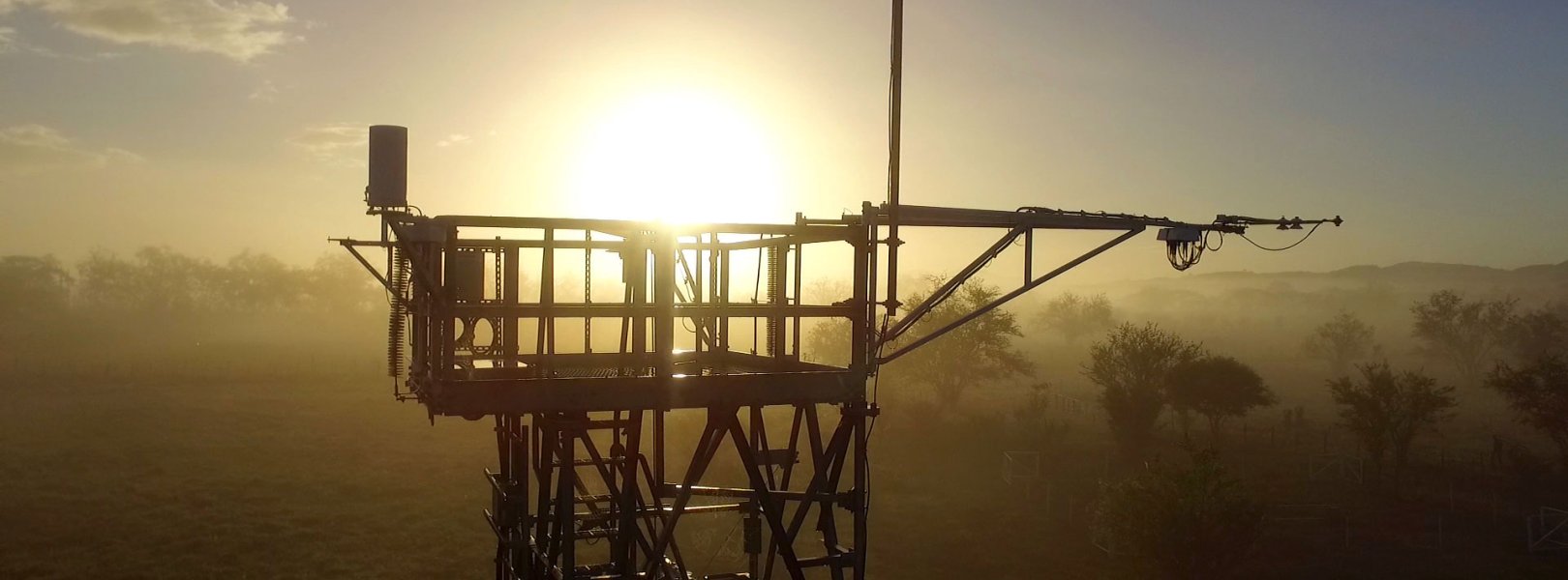
This site has a flux/meteorological tower that is 8 m (26 ft) tall with four measurement levels. The tower top extends above the vegetation canopy to allow sensors mounted at the top and along the tower to capture the full profile of atmospheric conditions from the top of the vegetation canopy to the ground. The tower collects physical and chemical properties of atmosphere-related processes, such as humidity, wind, and net ecosystem gas exchange. Precipitation data are collected by a tipping bucket at the top of the tower.

Phenocams

One phenocam is attached to the top and the bottom of the tower. Here we show the images from the most recent hour. The full collection of images can be viewed on the Phenocam Gallery - click on either of the images below.

Tower top

NEON.D04.LAJA.DP1.10033

Tower bottom

NEON.D04.LAJA.DP1.10042

Soil Sensor Measurements

This site has five soil plots placed in an array within the airshed of the flux tower. Photosynthetically Active Radiation (PAR) at soil surface, soil heat flux, and solar radiation are measured at the soil surface in each soil plot. Soil moisture, soil temperature, and CO2 concentration are measured at multiple depths in each soil plot.

Observational Sampling

At terrestrial sites, field ecologists observe birds and plants, and sample ground beetles, mosquitoes, small mammals, soil microbes, and ticks. Lab analyses are carried out to provide further data on DNA sequences, pathogens, soils, sediments, and biogeochemistry. Learn more about terrestrial observations or explore this site's data products.


Field Site Data

Site

Site Host

University of Puerto Rico

Site Access Allowed

Limited

Site Access Details

The site host actively encourages research at this site, however all requests will be evaluated on a case-by-case basis. Please note that due to the high density of research taking place in this area, it is critical to coordinate closely with the site host to ensure no conflicts with ongoing research.; > 6months prior to planned schedule.

Operations Office

NEON Field Operations Office

Domain 04 Support Facility

NEON Field Operations Address

45 Carr Ochoa
Guanica, Puerto Rico 00653

NEON Field Operations Phone

787.821.1214

Location

Latitude

18.021261

Longitude

-67.076889

Geodetic Datum

WGS84

UTM Northing

1993593.87m

UTM Easting

703591.13m

UTM Zone

19N

County

Lajas Municipio

State

PR

Country

US

Mean Elevation

16m

Minimum Elevation

13m

Maximum Elevation

41m

Climate

Mean Annual Temperature

25.0°C

Mean Annual Precipitation

830mm

Dominant Wind Direction

SSE

Vegetation

Mean Canopy Height

0.4m

Dominant NLCD Classes

Cultivated Crops, Grassland/Herbaceous, Pasture/Hay

Average number of green days

365

Tower

Tower Height

8m

Number of Tower Levels

4

Soils

Megapit Soil Family

Fine - mixed - superactive - isohyperthermic Sodic Haplusterts

Soil Subgroup

Sodic Haplusterts


Gallery

  • Photos
  • Videos

Related Field Sites

Other Domain D04 Field Sites

brown square white mountain icon Guanica Forest NEON
Core Terrestrial
blue square white drop icon Río Cupeyes NEON
Core Aquatic
blue circle white drop icon Río Yahuecas NEON
Gradient Aquatic

Other Field Sites in PR

brown square white mountain icon Guanica Forest NEON
Core Terrestrial
blue square white drop icon Río Cupeyes NEON
Core Aquatic
blue circle white drop icon Río Yahuecas NEON
Gradient Aquatic
NSF NEON, Operated by Battelle

Follow Us:

Join Our Newsletter

Get updates on events, opportunities, and how NEON is being used today.

Subscribe Now

Footer

  • About Us
  • Newsroom
  • Contact Us
  • Terms & Conditions
  • Careers
  • Code of Conduct

Copyright © Battelle, 2025

The National Ecological Observatory Network is a major facility fully funded by the U.S. National Science Foundation.

Any opinions, findings and conclusions or recommendations expressed in this material do not necessarily reflect the views of the U.S. National Science Foundation.