About Field Sites and Domains
NEON statistically partitioned the continental U.S., Hawaii, and Puerto Rico into 20 ecoclimatic Domains that represent distinct regions of vegetation, landforms, and ecosystem dynamics to capture the full range of U.S. ecological variations. In each Domain, NEON collects data about plants, animals, soil, nutrients, freshwater and the atmosphere using sensor measurements and field observations.
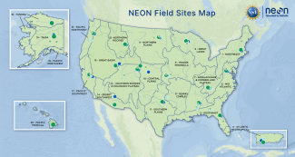
NEON field sites and ecoclimatic Domains
Spatial & Temporal Design
NEON collects data that can detect site-level to continental-scale change through the following sampling and design approaches.
Sampling design: Field sites across the continent
NEON operates 81 field sites strategically located across 20 ecoclimatic Domains across the United States, including 47 terrestrial field sites and 34 freshwater aquatic field sites. When logistically possible, aquatic and terrestrial sites are colocated (i.e. in close proximity) to support understanding of linkages across terrestrial and aquatic ecosystems and their interactions with the atmosphere. For example, Domain 08, the Ozarks Complex, has three co-located sets of terrestrial and aquatic field sites. These sites are situated along the same watershed system, creating a unique opportunity to study hydrology, nutrient transport, and biogeochemical cycling through the watershed.
Every Domain, except Domain 20 - Pacific Tropical, which only has one terrestrial site, has aquatic and terrestrial sites. These sites are designed to collect data for decades and, therefore, are primary locations for long-term studies of climate impacts and ecological change.
Scalable design: Local to continental data
NEON field-based measurements provide detailed information that characterizes local, site-level change. Airborne data combined with site-level data capture contiguous site-level information and can be combined with existing satellite data to support continental characterization of ecological processes. This coordinated data collection strategy uniquely addresses both local and regional questions in several key themes, such as biogeochemistry and ecohydrology.
NEON sites were carefully selected to examine local ecological changes within Domains and regional and continental changes across Domains. Multiple sites within each Domain allow for the comparison of ecological change across various ecological gradients, such as elevation and gradients. In addition, they provide an opportunity to compare unique habitat types, and examine the influences of different types of land use on ecosystems. For example, Domain 04, Atlantic Neotropical, has sites located in pristine wilderness areas and agricultural lands, giving researchers the ability to examine and monitor the impacts of nutrient loading and land use on wilderness ecosystems and the endemic and endangered species within them. Lastly, multiple NEON Domains allow for studying how drivers of ecological change (e.g. human population growth, land use changes, pollution) impact biological systems and ecosystems across regions.
Location criteria for NEON sites included:
- Representation of wildland conditions in respective ecoclimatic Domains (core sites);
- Proximity to other sites within the Domain for logistical convenience;
- Long-term accessibility via permitting and secure land tenure;
- Availability for regular air survey with unimpeded air space, if possible; and
- Comparability to other sites within the Domains
Learn more about NEON's spatiotemporal and science design
Management
Each Domain includes one Domain Site Facility (DSF) (except Domains 10/13 in Colorado, and Domains 18/19 in Alaska, where each pair is based out of one facility). Each DSF is managed by Domain Manager and has a field crew made up of full-time NEON field ecologists and seasonal field technicians. This field crew travels to field sites from the DSF to conduct observational sampling. Sampling schedules and logistics are coordinated out of the DSF. In addition, samples are prepared and processed at the DSF and then shipped to private laboratories for further analyses. Staff working at the DSF regularly communicate with Headquarters Science Team staff to ensure all sensor equipment is working and sampling protocols are up-to-date.
Field Site Basics
Across all field sites,
- Airborne Remote Sensing surveys are scheduled every two to five years,
- Automated Instruments collect data year round, and
- Observational Sampling is conducted by field scientists during the growing season.
The data collection and processing methods used by NEON are standardized and well documented across all sites. NEON data and documentation are open access and available for download via the NEON data portal.
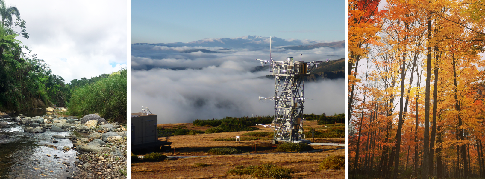
Terrestrial Field Sites
Weather conditions along with seasonally changing biological and biogeochemical processes are important drivers and indicators of terrestrial ecosystem function. To better understand these processes, NEON collects data at 47 terrestrial field sites across the United States.
At each terrestrial field site, NEON collects data to understand changes in climate, surface-atmosphere interactions, biogeochemical processes, organismal populations, and habitat structure.
Data Collection Specific to Terrestrial Sites
Automated Instruments
The NEON Terrestrial Instrument System (TIS) deploys automated instruments to collect meteorological, soil, and phenological data at terrestrial field sites. Data are collected continuously to capture patterns and cycles across time scales ranging from seconds to years. The automated instrumentation at terrestrial sites includes:
- A micrometeorological tower to collect weather and climate data, including fluxes of carbon, water, and energy between the terrestrial ecosystem and the atmosphere.
- A soil sensor array to measure physical and chemical properties of soil at various depths, and soil heat flux at the soil surface.
- Precipitation gauges: Primary precipitation is collected using a Double Fence Intercomparison Reference (DFIR), and secondary precipitation using a tipping bucket on the tower. Throughfalls are also placed in the soil array at most terrestrial sites.
- Two phenocams to capture changes in foliar phenophases above and below the canopy.
Observational Sampling
The NEON Terrestrial Observation System (TOS) captures data to quantify the long-term dynamics of abundance, diversity, pathogen prevalence, phenology, and productivity within an ecosystem. Field technicians collect samples and data during the growing season, which can be very short in northern sites and very long in southern sites. Terrestrial observations characterize plant phenology, diversity, biomass, abundance, and productivity. Technicians also capture the abundance, diversity, and phenology of organisms including birds, small mammals, ticks, mosquitoes, ground beetles and soil microbes. Pathogen status is assessed for ticks, mosquitoes and small mammals. Additionally, chemical properties and isotopes of soils, sediments and plant tissues are assessed.
Aquatic Field Sites
Hydrologic drivers, weather and climate conditions, and seasonal biological and biogeochemical transitions are important drivers and indicators of freshwater aquatic ecosystem function. To better understand these processes, NEON collects data at 34 freshwater aquatic field sites located across the United States including 24 wadeable streams, seven lakes, and three non-wadeable rivers.
At each aquatic field site, NEON collects data to understand changes in freshwater and biogeochemical processes, organismal populations and habitat structure.
NEON uses a standardized methodology at all aquatic sites (with a few exceptions in field sites with permafrost) which means the data are comparable across all NEON field sites. Please note that currently there are no aquatic sites in D20: Pacific Neotropical (Hawaii).
Types of Aquatic Sites
Streams
NEON wadeable streams are defined as stretches of flowing water that are safely wadeable during most, if not all, of the year. Ideal NEON stream reaches have up to a 1 km permitted length that is free of major flow obstructions or major tributaries. The length of this reach allows for the wide range of biological, chemical, and physical parameters to be collected and to best capture across multiple habitat types (e.g., pools, riffles, and runs).
Rivers
NEON non-wadeable rivers are defined as stretches of flowing water that are navigable by boat. NEON river sites were chosen to allow year-round access to a 1 km reach for field measurement and sampling similar to streams. Each river site has representative shoreline characteristics of the region and also accommodates the placement of a buoy in a location that captures the main flow, but is outside of navigation channels.
Lakes
NEON lakes are defined as stationary bodies of water that may separate into layers of different density and temperature for some period of time during the year. NEON lake sites have representative characteristics of the region they are located in, relative to size, hydrologic flow (i.e. seepage vs flow-through), and shoreline characteristics. Each lake must also accommodate the placement of a buoy that can be continuously accessed in the deepest basin during ice-free periods.
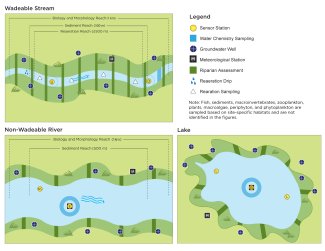
Schematics showing spatial placement of automated instruments at stream, river and lake sites.
Data Collection Specific to Aquatic Sites
Automated Instruments
The NEON Aquatic Instrument System (AIS) deploys automated instruments to collect information about physical and chemical properties of freshwater aquatic water bodies, the surrounding atmosphere, and adjacent riparian areas. Data are collected continuously to capture patterns and cycles across time scales ranging from seconds to years. These instruments are capable of collecting information at limited spatial scales but with high temporal resolution (many measurements per hour). Instruments measure meteorological conditions near aquatic water bodies and in-situ sensors measure water quality parameters to allow direct integration and interpolation between measurements. The AIS is comprised of three primary sensor arrays that collect the following data:
- Surface water quality and depth
- Groundwater
- Meteorological Stations to collect weather and climate data that are comparable to meteorological data collected at terrestrial field sites.
- Phenocams to collect image data for qualitative estimates of snow cover, riparian characteristics or weather.
Observational Sampling
The NEON Aquatic Observation System (AOS) is designed to provide standardized, continentally-distributed observations of organisms, biogeochemistry, and physical properties. Field technicians collect data during the growing season. NEON's observational sampling approach was selected to include organisms from representative aquatic habitats with varying lifespans and trophic positions. Aquatic observations characterize channel and lake morphology, organism abundance and diversity, biogeochemistry, seasonal climatic and hydrologic changes, and riparian phenology. More specifically, field technicians collect data on the community composition of aquatic plants and algae, aquatic microbes, macroinvertebrates and zooplankton, fish and riparian vegetation. Additionally, critical physical properties of NEON aquatic ecosystems are quantified through measurements including, but not limited to secchi depth, temperature depth profiles, stream discharge, stream morphology (maps), and lake and river bathymetry (maps). The chemical properties and isotopes of aquatic plants and microalgae are also assessed. Aquatic sites are colocated with terrestrial sites (see Table 1).
| Domain-Site | Site Type | Nearby Terr. Site(s) | Dist. to Tower(s) (km) | Water-shed Area (km2) | Water-shed AOP Coverage |
|---|---|---|---|---|---|
| D01 - HOPB | Stream | HARV | 14.8 | 12.0 | Complete |
| D02 - LEWI | Stream | BLAN | 8.7 | 11.9 | Complete |
| D02 - POSE | Stream | SCBI* | 0.8 | 2.0 | Complete |
| D03 - BARC | Lake | OSBS | 2.4 | 31.3 | Complete |
| D03 - FLNT | River | JERC | 3.5 | 14,999 | Partial, will not complete |
| D03 - SUGG | Lake | OSBS | 2.6 | 39.6 | Complete |
| D04 - CUPE | Stream | LAJA | 13.7 | 4.3 | Complete |
| D04 - GUIL | Stream | GUAN | 23.8 | 9.6 | Partial, will complete |
| D05 - CRAM | Lake | UNDE | 5.2 | 0.6 | Complete |
| D05 - LIRO | Lake | STEI | 55.4 | 0.9 | Complete |
| D06 - KING | Stream | KONA, KONZ* | 1.0, 3.5 | 13.0 | Complete |
| D06 - MCDI | Stream | KONZ | 20.0 | 22.6 | Complete |
| D07 - LECO | Stream | GRSM* | 0.4 | 9.1 | Complete |
| D07 - WALK | Stream | ORNL* | 0.8 | 1.1 | Complete |
| D08 - BLWA | River | DELA, TALL* | 0.6, 59.4* | 16,159 | Partial, will not complete |
| D08 - MAYF | Stream | TALL* | 1.9 | 14.4 | Complete |
| D08 -TOMB | River | LENO, DELA*, TALL* | 0.4, 8.4, 1,410 | 47,085 | Partial, will not complete |
| D09 -PRLA | Lake | DCFS | 1.2 | 3.4 | Complete |
| D09 - PRPO | Lake | WOOD | 0.8 | 2.1 | Complete |
| D10 - ARIK | Stream | STER | 92.5 | 2,632 | Partial, will not complete |
| D11 - BLUE | Stream | CLBJ | 145.4 | 322 | Partial, will possibly complete |
| D11 - PRIN | Stream | CLBJ | 19.8 | 48.9 | Complete |
| D12 - BLDE | Stream | YELL | 4.0 | 37.8 | Complete |
| D13 - COMO | Stream | NIWO | 3.9 | 3.6 | Complete |
| D13 - WLOU | Stream | NIWO | 33.7 | 4.9 | Complete |
| D14 - SYCA | Stream | SRER | 213.5 | 280 | Partial, will not complete |
| D15 - REDB | Stream | ONAQ | 87.2 | 16.7 | Complete |
| D16 - MART | Stream | WREF | 3.4 | 6.3 | Complete |
| D16 - MCRA | Stream | ABBY, WREF | 167.5, 174.3 | 3.9 | Complete |
| D17 - BIGC | Stream | SOAP | 2.8 | 10.9 | Complete |
| D17 - TECR | Stream | TEAK | 5.9 | 3.0 | Complete |
| D18 - OKSR | Stream | TOOL | 9.3 | 57.8 | Complete |
| D18 - TOOK | Lake | TOOL | 10.3 | 67.6 | Complete |
| D19 - CARI | Stream | BONA | 0.1 | 31.0 | Complete |
The watershed is defined as the area of land draining into each water body from the most downstream sensor set (streams and rivers) or the littoral 2 sensor set (lakes). Watershed shapefiles can be downloaded from the NEON spatial data & maps page. See Algorithm Theoretical Basis Document (ATBD): Watershed delineation for NEON aquatic sites (NEON.DOC.005246) for details on how the watershed areas in this table were determined. The future AOP flight schedules can be used to determine the most likely timing of the next flight over an aquatic site and/or watershed. *Indicates a terrestrial site that is within the upstream watershed of the aquatic site. At some sites the nearby tower is located on the other side of a ridge (e.g., COMO) or the tower is located downstream of the aquatic sensors (e.g., MART) but is not within the upstream watershed, whereas the TALL tower is over 1,000 km away from TOMB but is within the watershed.
Archival Samples Collection
Each year, NEON collects around a hundred thousand samples from field sites. These samples are processed and then housed at the NEON biorepository for users to check out and use in their research studies. Learn more about the biological, environmental, and genomic samples and specimens and how to access them.
Extending Ecosystem Research Studies
NEON data collection methods are carefully selected and documented to generate standardized data sets across NEON field sites and that are compatible with existing historical data and/or data collected by other monitoring programs and large-scale data repositories, such as LTER, AmeriFlux, the USA National Phenology Network, Barcode of Life Databases, the National Water Quality Assessment (NAWQA), a program of the U.S. Geological Survey (USGS), and the U.S. Environmental Protection Agency (EPA) programs National Rivers and Streams Assessment (NRSA) and the National Lakes Assessment program (NLA). Together, NEON and these existing programs enable a more holistic understanding of aquatic and terrestrial ecosystems in the United States. In addition to providing free open access data and archival samples, NEON also serves as an infrastructure that researchers may leverage to conduct experiments and collect additional types of data.
Access Field Sites and Use NEON Infrastructure
In addition to standardized monitoring and sampling from year to year, NEON field sites also serve as an infrastructure to support additional research. Independent observers and Principal Investigators (PI) may work with Battelle staff on the NEON program to add additional instruments to existing NEON infrastructure and/or conduct additional sampling and/or experiments at NEON field sites.
Please note that the NEON program does not own the land for any of its field sites. Instead, Battelle, the managing contractor for the NEON program, coordinates and partners with a variety of site hosts to build and operate sites. As a result, permissions for additional non-NEON research activities must be ultimately obtained from site hosts, a process that the NEON program can assist researchers as needed. Learn more about how to use NEON infrastructure.