NSF NEON | Open Data to Understand our Ecosystems logo

Main navigation

  • About Us
    • Overview
      • Spatial and Temporal Design
      • History
    • Vision and Management
    • Advisory Groups
      • Science, Technology & Education Advisory Committee
      • Technical Working Groups (TWGs)
    • FAQ
    • Contact Us
      • Field Offices
    • User Accounts
    • Staff

    About Us

  • Data & Samples
    • Data Portal
      • Explore Data Products
      • Data Availability Charts
      • Spatial Data & Maps
      • Document Library
      • API & GraphQL
      • Prototype Data
      • External Lab Data Ingest (restricted)
    • Samples & Specimens
      • Discover and Use NEON Samples
        • Sample Types
        • Sample Repositories
        • Sample Explorer
        • Megapit and Distributed Initial Characterization Soil Archives
        • Excess Samples
      • Sample Processing
      • Sample Quality
      • Taxonomic Lists
    • Collection Methods
      • Protocols & Standardized Methods
      • Airborne Remote Sensing
        • Flight Box Design
        • Flight Schedules and Coverage
        • Daily Flight Reports
          • AOP Flight Report Sign Up
        • Camera
        • Imaging Spectrometer
        • Lidar
      • Automated Instruments
        • Site Level Sampling Design
        • Sensor Collection Frequency
        • Instrumented Collection Types
          • Meteorology
          • Phenocams
          • Soil Sensors
          • Ground Water
          • Surface Water
      • Observational Sampling
        • Site Level Sampling Design
        • Sampling Schedules
        • Observation Types
          • Aquatic Organisms
            • Aquatic Microbes
            • Fish
            • Macroinvertebrates & Zooplankton
            • Periphyton, Phytoplankton, and Aquatic Plants
          • Terrestrial Organisms
            • Birds
            • Ground Beetles
            • Mosquitoes
            • Small Mammals
            • Soil Microbes
            • Terrestrial Plants
            • Ticks
          • Hydrology & Geomorphology
            • Discharge
            • Geomorphology
          • Biogeochemistry
          • DNA Sequences
          • Pathogens
          • Sediments
          • Soils
            • Soil Descriptions
    • Data Notifications
    • Data Guidelines and Policies
      • Acknowledging and Citing NEON
      • Publishing Research Outputs
      • Usage Policies
    • Data Management
      • Data Availability
      • Data Formats and Conventions
      • Data Processing
      • Data Quality
      • Data Product Revisions and Releases
        • Release 2021
        • Release 2022
        • Release 2023
      • NEON and Google
      • Externally Hosted Data

    Data & Samples

  • Field Sites
    • About Field Sites and Domains
    • Explore Field Sites
    • Site Management Data Product

    Field Sites

  • Impact
    • Observatory Blog
    • Case Studies
    • Spotlights
    • Papers & Publications
    • Newsroom
      • NEON in the News
      • Newsletter Archive
      • Newsletter Sign Up

    Impact

  • Resources
    • Getting Started with NEON Data & Resources
    • Documents and Communication Resources
      • Papers & Publications
      • Document Library
      • Outreach Materials
    • Code Hub
      • Code Resources Guidelines
      • Code Resources Submission
      • NEON's GitHub Organization Homepage
    • Learning Hub
      • Science Videos
      • Tutorials
      • Workshops & Courses
      • Teaching Modules
      • Faculty Mentoring Networks
      • Data Education Fellows
    • Research Support and Assignable Assets
      • Field Site Coordination
      • Letters of Support
      • Mobile Deployment Platforms
      • Permits and Permissions
      • AOP Flight Campaigns
      • Excess Samples
      • Assignable Assets FAQs
    • Funding Opportunities

    Resources

  • Get Involved
    • Advisory Groups
      • Science, Technology & Education Advisory Committee
      • Technical Working Groups
    • Upcoming Events
    • Past Events
    • NEON Ambassador Program
    • Collaborative Works
      • EFI-NEON Ecological Forecasting Challenge
      • NCAR-NEON-Community Collaborations
      • NEON Science Summit
      • NEON Great Lakes User Group
    • Community Engagement
    • Science Seminars and Data Skills Webinars
    • Work Opportunities
      • Careers
      • Seasonal Fieldwork
      • Postdoctoral Fellows
      • Internships
        • Intern Alumni
    • Partners

    Get Involved

  • My Account
  • Search

Search

Learning Hub

  • Science Videos
  • Tutorials
  • Workshops & Courses
  • Teaching Modules
  • Faculty Mentoring Networks
  • Data Education Fellows

Breadcrumb

  1. Resources
  2. Learning Hub
  3. Tutorials
  4. Hierarchical Data Formats - What is HDF5?

Tutorial

Hierarchical Data Formats - What is HDF5?

Authors: Leah A. Wasser

Last Updated: Oct 7, 2020

Learning Objectives

After completing this tutorial, you will be able to:

  • Explain what the Hierarchical Data Format (HDF5) is.
  • Describe the key benefits of the HDF5 format, particularly related to big data.
  • Describe both the types of data that can be stored in HDF5 and how it can be stored/structured.

About Hierarchical Data Formats - HDF5

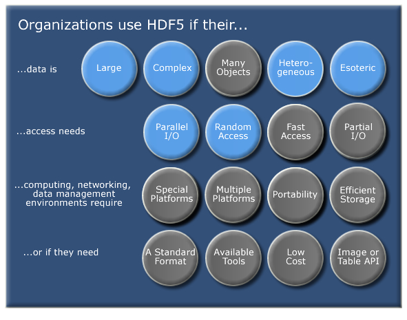
The Hierarchical Data Format version 5 (HDF5), is an open source file format that supports large, complex, heterogeneous data. HDF5 uses a "file directory" like structure that allows you to organize data within the file in many different structured ways, as you might do with files on your computer. The HDF5 format also allows for embedding of metadata making it self-describing.

**Data Tip:** HDF5 is one hierarchical data format, that builds upon both HDF4 and NetCDF (two other hierarchical data formats). Read more about HDF5 here.
Organizations use HDF5 for various data, access, computing, and networking needs
Why Use HDF5. Source: The HDF5 Group

Hierarchical Structure - A file directory within a file

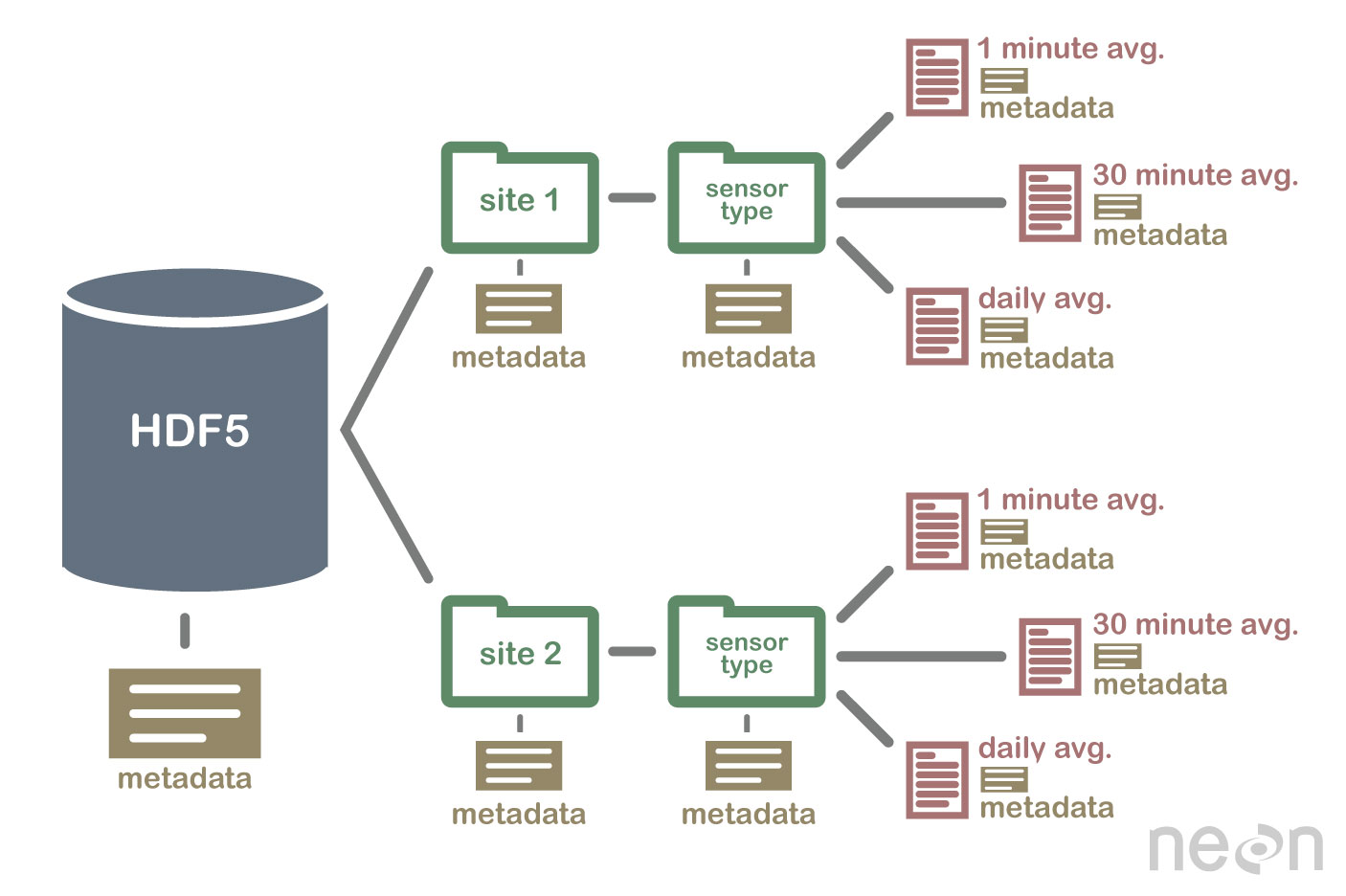
The HDF5 format can be thought of as a file system contained and described within one single file. Think about the files and folders stored on your computer. You might have a data directory with some temperature data for multiple field sites. These temperature data are collected every minute and summarized on an hourly, daily and weekly basis. Within one HDF5 file, you can store a similar set of data organized in the same way that you might organize files and folders on your computer. However in a HDF5 file, what we call "directories" or "folders" on our computers, are called groups and what we call files on our computer are called datasets.

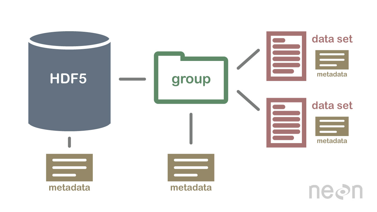
2 Important HDF5 Terms

  • Group: A folder like element within an HDF5 file that might contain other groups OR datasets within it.
  • Dataset: The actual data contained within the HDF5 file. Datasets are often (but don't have to be) stored within groups in the file.
An illustration of a HDF5 file structure which contains groups, datasets and associated metadata
An example HDF5 file structure which contains groups, datasets and associated metadata.

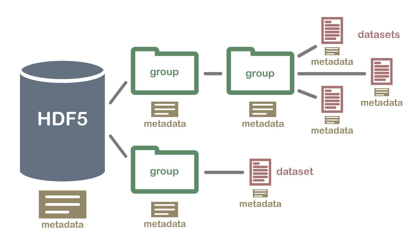
An HDF5 file containing datasets, might be structured like this:

The HDF5 illustration from above but the groups are NEON sites and sensor types and datasets are included under sensor types
An example HDF5 file structure containing data for multiple field sites and also containing various datasets (averaged at different time intervals).

HDF5 is a Self Describing Format

HDF5 format is self describing. This means that each file, group and dataset can have associated metadata that describes exactly what the data are. Following the example above, we can embed information about each site to the file, such as:

  • The full name and X,Y location of the site
  • Description of the site.
  • Any documentation of interest.

Similarly, we might add information about how the data in the dataset were collected, such as descriptions of the sensor used to collect the temperature data. We can also attach information, to each dataset within the site group, about how the averaging was performed and over what time period data are available.

One key benefit of having metadata that are attached to each file, group and dataset, is that this facilitates automation without the need for a separate (and additional) metadata document. Using a programming language, like R or Python, we can grab information from the metadata that are already associated with the dataset, and which we might need to process the dataset.

An illustration of a HDF5 file structure with a group that contains two datasets and all associated metadata
HDF5 files are self describing - this means that all elements (the file itself, groups and datasets) can have associated metadata that describes the information contained within the element.

Compressed & Efficient subsetting

The HDF5 format is a compressed format. The size of all data contained within HDF5 is optimized which makes the overall file size smaller. Even when compressed, however, HDF5 files often contain big data and can thus still be quite large. A powerful attribute of HDF5 is data slicing, by which a particular subsets of a dataset can be extracted for processing. This means that the entire dataset doesn't have to be read into memory (RAM); very helpful in allowing us to more efficiently work with very large (gigabytes or more) datasets!

Heterogeneous Data Storage

HDF5 files can store many different types of data within in the same file. For example, one group may contain a set of datasets to contain integer (numeric) and text (string) data. Or, one dataset can contain heterogeneous data types (e.g., both text and numeric data in one dataset). This means that HDF5 can store any of the following (and more) in one file:

  • Temperature, precipitation and PAR (photosynthetic active radiation) data for a site or for many sites
  • A set of images that cover one or more areas (each image can have specific spatial information associated with it - all in the same file)
  • A multi or hyperspectral spatial dataset that contains hundreds of bands.
  • Field data for several sites characterizing insects, mammals, vegetation and climate.
  • A set of images that cover one or more areas (each image can have unique spatial information associated with it)
  • And much more!

Open Format

The HDF5 format is open and free to use. The supporting libraries (and a free viewer), can be downloaded from the HDF Group website. As such, HDF5 is widely supported in a host of programs, including open source programming languages like R and Python, and commercial programming tools like Matlab and IDL. Spatial data that are stored in HDF5 format can be used in GIS and imaging programs including QGIS, ArcGIS, and ENVI.

Summary Points - Benefits of HDF5

  • Self-Describing The datasets with an HDF5 file are self describing. This allows us to efficiently extract metadata without needing an additional metadata document.
  • Supporta Heterogeneous Data: Different types of datasets can be contained within one HDF5 file.
  • Supports Large, Complex Data: HDF5 is a compressed format that is designed to support large, heterogeneous, and complex datasets.
  • Supports Data Slicing: "Data slicing", or extracting portions of the dataset as needed for analysis, means large files don't need to be completely read into the computers memory or RAM.
  • Open Format - wide support in the many tools: Because the HDF5 format is open, it is supported by a host of programming languages and tools, including open source languages like R and Python and open GIS tools like QGIS.

Questions?

If you have questions or comments on this content, please contact us.

Contact Us
NEON Logo

Follow Us:

Join Our Newsletter

Get updates on events, opportunities, and how NEON is being used today.

Subscribe Now

Footer

  • My Account
  • About Us
  • Newsroom
  • Contact Us
  • Terms & Conditions
  • Careers

Copyright © Battelle, 2019-2020

The National Ecological Observatory Network is a major facility fully funded by the National Science Foundation.

Any opinions, findings and conclusions or recommendations expressed in this material do not necessarily reflect the views of the National Science Foundation.