Research Highlight
Answering Burning Questions About Wildfire Fuel and Emissions
May 15, 2019
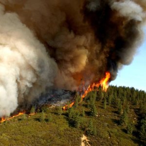
Wildfires are a growing problem in the American West, consuming millions of acres of land and causing billions of dollars in damages annually. Frequent droughts caused by significant weather changes are expected to make matters worse in the decades to come. But how much do we really understand about how these fires burn, what they emit, and the relationships between vegetation in the landscape and fire intensity, spread and emissions?
A new study funded through the National Science Foundation (NSF) Rapid Response to Funding (RAPID) Grant program attempts to answer critical questions about the correlations between biomass burned from wildfires and the emitted quantities of trace gases and aerosols. "Airborne LIDAR and Hyperspectral Observations to Support Ecological Characterization of Wildfire-Affected Areas" is a joint undertaking by the NEON program and University of Colorado–Boulder in partnership with BB-FLUX, an existing NSF supported project. The study is jointly led by Tristan Goulden, NEON Remote Sensing Lead Research Scientist, and Rainer Volkamer, Associate Professor of Chemistry (and CIRES Fellow) at CU–Boulder and Principal Investigator of the BB-FLUX project.
Rainer says, "I am excited about our collaboration with NEON. The atmospheric and ecosystem communities study complementary aspects of wildfires, but this is really the first time our communities have worked together."
Burning Questions
Wildfires need fuel to grow and spread. This fuel is primarily provided by biomass, or organic matter in the form of vegetation growing in the ecosystem. The amount, type and moisture content of the vegetation influence how large a wildfire can get and how fast it can spread. The type of fuel the fire burns is also directly related to the chemical composition of the particulates and aerosol emissions it produces.
"We are just beginning to be able to quantify the mass of fuel on the ground that ends up as smoke in the air," says Rainer. "Fire smoke is a soup of chemicals, composed of trace gases like carbon monoxide, carbon dioxide, ammonia and other reactive gases, and aerosols. Quantifying the mass and composition of smoke that ends up in the air is one of the BB-FLUX science objectives. It connects with the fuel characterization that NEON and the U.S. Forest Service are doing on the ground."
Understanding the relationships between ecosystems, long-term weather changes and fire activity will help researchers answer critical questions, such as:
- How do ecosystem characteristics and total available biomass impact the growth and spread of wildfires?
- How is the chemical composition of smoke plumes produced by wildfires related to the volume and type of biomass found in the ecosystem?
Answering these questions could lead to development of better models that could be used to predict how wildfires spread in different ecosystems and under different conditions. Tristan explains, "We're trying to improve the estimates of total biomass that researchers can get from remote sensing data. We can use that data to build models that give us better predictions of wildfire spread and emissions. This will also help us predict how changes in biomass resulting from long-term weather change may influence fire activity in the future."
These questions are especially urgent now as concerns about wildfire activity continue to grow in the western U.S. Wildfires in 2017 and 2018 burned more than 18 million acres of land, resulting in record levels of damages. Six of the ten costliest wildfires on record occurred in the last two years, including the deadly California Camp Fire of November 2018 and Santa Rosa Fire of November 2017.
Droughts and insect damage resulting from long-term weather change and invasive species, along with changes in land use to accommodate human settlement and agriculture, are changing the volume and composition of vegetation in ecosystems over time. Understanding how these changes in available biomass could influence future fire activity will be important for researchers, policy makers and land managers. A better understanding of wildfire emissions will also help the public health community develop science-based policies to protect vulnerable populations exposed to smoke from wildfires.
Characterizing Ecosystems and Emissions in Wildfire-Affected Areas
The study characterized biomass availability and smoke plumes at four areas impacted by wildfires in 2018. Each area had distinct ecosystem characteristics, allowing researchers to analyze wildfires occurring across a range of western ecosystems.
- The Teepee Fire burned more than 2,000 acres southeast of Bend, OR in early September 2018. This area is characterized by open savanna grass dotted by individual trees.
- The Watson Creek Fire burned nearly 60,000 acres near Paisley, OR in August 2018. This is a semi-arid steppe climate with a mix of conifers and high-elevation meadows. This area contained significant dead and down vegetation due to widespread insect-caused mortality in recent years.
- The Miriam Fire burned 5,400 acres just outside Gifford-Pinchot National Forest, west of Yakima, WA in August 2018. On the eastern edge of the Cascades, this is an alpine forest area dominated by tall conifer trees with a heavy brush understory.
- The Keithly Fire burned 17,600 acres in western Idaho near Midvale, ID in July and August 2018. The primary fuels here were brush and dry grass.
Researchers conducted two types of characterization for each fire.
- The BB-FLUX project deployed remote sensing and in-situ instruments to determine the pyrogenic carbon emission fluxes and the chemical composition of trace gases and aerosols that make up the smoke plume. This characterization is conducted using the University of Colorado Solar Occultation Flux (CU SOF), direct sun differential optical absorption spectroscopy (DS-DOAS), and in-situ instruments mounted on a Wyoming King Air (N2UW) research aircraft. These observations occur during peak activity of the wildfire, with the airborne platform traversing and viewing well-formed plumes of the burning biomass. This allows quantification of the total carbon flux (gas and aerosol flux) to the atmosphere, as well as critical chemical constituents of the plume; e.g., carbon monoxide (CO), ammonia (NH3) and ozone (O3).
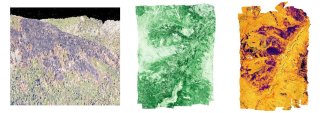
- The NEON Airborne Remote Sensing team used a NEON Airborne Observation Platform (AOP) to measure the extent of the burned areas and characterize and quantify the biomass present in the ecosystem. The AOP carries an array of instruments including both discrete and waveform LiDAR systems, an imaging spectrometer and high-resolution digital cameras. These instruments provide detailed information about the structure and composition of the vegetation, including both canopy and sub-canopy measurements. They also provide information about "greenness," which indicates photosynthetic activity and moisture content. These flights were conducted between September 16 and 21, 2018, after the fires were primarily extinguished and the observations associated with the BB-FLUX campaign had been made.
The NEON data will be used to estimate the total available biomass in each wildfire-affected area. Data from unburned vegetation on land surrounding the fire-impacted areas can be used to extrapolate the total biomass contained in each area prior to the fires.
Correlating the amount and type of biomass available for consumption with the emissions produced and other fire data will provide important insights about how wildfires spread in different ecosystems and how variations in biofuel influence the chemical composition of smoke plumes. The U.S. Forest Service has expressed an interest in the collected data. They have collected additional ground observations at Teepee and Keithly that could support future research efforts.
The NEON data, which have been shared with the U.S. Forest Service, may help in the development of fuel models that could be used to determine the percentage of total available biomass actually consumed by each fire. Calculating this "combustion completion" ratio is a very challenging interdisciplinary problem and presents an interesting opportunity for future research.
Putting NEON Assets to Work
Rainer is enthusiastic about the potential of the collaboration between BB-FLUX and NEON. "The scientific synergies and student opportunities for learning are tremendous. A lot remains to be done."
The NEON portion of the study was conducted under the NEON Assignable Assets program, which makes the AOPs and other NEON infrastructure available to researchers for projects outside the scope of the NEON program. Funding for the AOP flights was provided by NSF under the RAPID grant program.
Researchers interested in contracting with NEON/Battelle for use of the AOP should review and fill out the downloadable materials for the program and then send them to AssignableAssetRequests@battelleecology.org.