NSF NEON, Operated by Battelle

Main navigation

  • About Us
    • Overview
      • Spatial and Temporal Design
      • History
    • Vision and Management
    • Advisory Groups
      • Science, Technology & Education Advisory Committee
      • Technical Working Groups (TWGs)
    • FAQ
    • Contact Us
      • Contact NEON Biorepository
      • Field Offices
    • User Accounts
    • Staff
    • Code of Conduct

    About Us

  • Data & Samples
    • Data Portal
      • Explore Data Products
      • Data Availability Charts
      • Spatial Data & Maps
      • Document Library
      • API & GraphQL
      • Prototype Data
      • External Lab Data Ingest (restricted)
    • Data Themes
      • Biogeochemistry
      • Ecohydrology
      • Land Cover and Processes
      • Organisms, Populations, and Communities
    • Samples & Specimens
      • Discover and Use NEON Samples
        • Sample Types
        • Sample Repositories
        • Sample Explorer
        • Megapit and Distributed Initial Characterization Soil Archives
      • Sample Processing
      • Sample Quality
      • Taxonomic Lists
    • Collection Methods
      • Protocols & Standardized Methods
      • Airborne Remote Sensing
        • Flight Box Design
        • Flight Schedules and Coverage
        • Daily Flight Reports
          • AOP Flight Report Sign Up
        • Camera
        • Imaging Spectrometer
        • Lidar
      • Automated Instruments
        • Site Level Sampling Design
        • Sensor Collection Frequency
        • Instrumented Collection Types
          • Meteorology
          • Phenocams
          • Soil Sensors
          • Ground Water
          • Surface Water
      • Observational Sampling
        • Site Level Sampling Design
        • Sampling Schedules
        • Observation Types
          • Aquatic Organisms
            • Aquatic Microbes
            • Fish
            • Macroinvertebrates & Zooplankton
            • Periphyton, Phytoplankton, and Aquatic Plants
          • Terrestrial Organisms
            • Birds
            • Ground Beetles
            • Mosquitoes
            • Small Mammals
            • Soil Microbes
            • Terrestrial Plants
            • Ticks
          • Hydrology & Geomorphology
            • Discharge
            • Geomorphology
          • Biogeochemistry
          • DNA Sequences
          • Pathogens
          • Sediments
          • Soils
            • Soil Descriptions
        • Optimizing the Observational Sampling Designs
    • Data Notifications
    • Data Guidelines and Policies
      • Acknowledging and Citing NEON
      • Publishing Research Outputs
      • Usage Policies
    • Data Management
      • Data Availability
      • Data Formats and Conventions
      • Data Processing
      • Data Quality
      • Data Product Bundles
      • Data Product Revisions and Releases
        • Release 2021
        • Release 2022
        • Release 2023
        • Release 2024
        • Release-2025
      • NEON and Google
      • Externally Hosted Data

    Data & Samples

  • Field Sites
    • About Field Sites and Domains
    • Explore Field Sites
    • Site Management Data Product

    Field Sites

  • Impact
    • Observatory Blog
    • Case Studies
    • Papers & Publications
    • Newsroom
      • NEON in the News
      • Newsletter Archive
      • Newsletter Sign Up

    Impact

  • Resources
    • Getting Started with NEON Data & Resources
    • Documents and Communication Resources
      • Papers & Publications
      • Document Library
      • Outreach Materials
    • Code Hub
      • Code Resources Guidelines
      • Code Resources Submission
      • NEON's GitHub Organization Homepage
    • Learning Hub
      • Science Videos
      • Tutorials
      • Workshops & Courses
      • Teaching Modules
    • Research Support Services
      • Field Site Coordination
      • Letters of Support
      • Mobile Deployment Platforms
      • Permits and Permissions
      • AOP Flight Campaigns
      • Research Support FAQs
      • Research Support Projects
    • Funding Opportunities

    Resources

  • Get Involved
    • Advisory Groups
      • Science, Technology & Education Advisory Committee
      • Technical Working Groups
    • Upcoming Events
    • NEON Ambassador Program
      • Exploring NEON-Derived Data Products Workshop Series
    • Research and Collaborations
      • Environmental Data Science Innovation and Inclusion Lab
      • Collaboration with DOE BER User Facilities and Programs
      • EFI-NEON Ecological Forecasting Challenge
      • NEON Great Lakes User Group
      • NEON Science Summit
      • NCAR-NEON-Community Collaborations
        • NCAR-NEON Community Steering Committee
    • Community Engagement
      • How Community Feedback Impacts NEON Operations
    • Science Seminars and Data Skills Webinars
      • Past Years
    • Work Opportunities
      • Careers
      • Seasonal Fieldwork
      • Internships
        • Intern Alumni
    • Partners

    Get Involved

  • My Account
  • Search

Search

Overview

  • Spatial and Temporal Design
  • History

Breadcrumb

  1. About Us
  2. Overview
  3. Spatial and Temporal Design

Spatial and Temporal Design

Globe for design page

Quantifying ecological processes over time and large spatial extents requires a complex spatiotemporal sampling design. To characterize ecological change and uniquely support studies that link individual local measurements to site-level and continental-scale questions about ecological change, the Observatory:

  • Strategically locates sites across the U.S. to capture variability in ecological and climatological conditions;
  • Monitors and records conditions at varying time scales from multiple data points per second to multiple data points per year;
  • Calculates statistics and uncertainties for wider time ranges, such as 30-minute, daily, monthly, and yearly;
  • Coordinates local measurements in the field with high-resolution airborne remote sensing data, which may be further integrated with datasets generated by other researchers or scientific organizations; and
  • Provides resources, such as collection and processing protocols as well as code resources, for the ecological community to take comparable measurements and samples, and integrate observations and datasets independently.

Read the 2011 Science Strategy document

2021_04_Graphic_Domain_Map Field sites_w_rivers_png
NEON ecoclimactic Domains and field sites

Scalable Design: Local to National

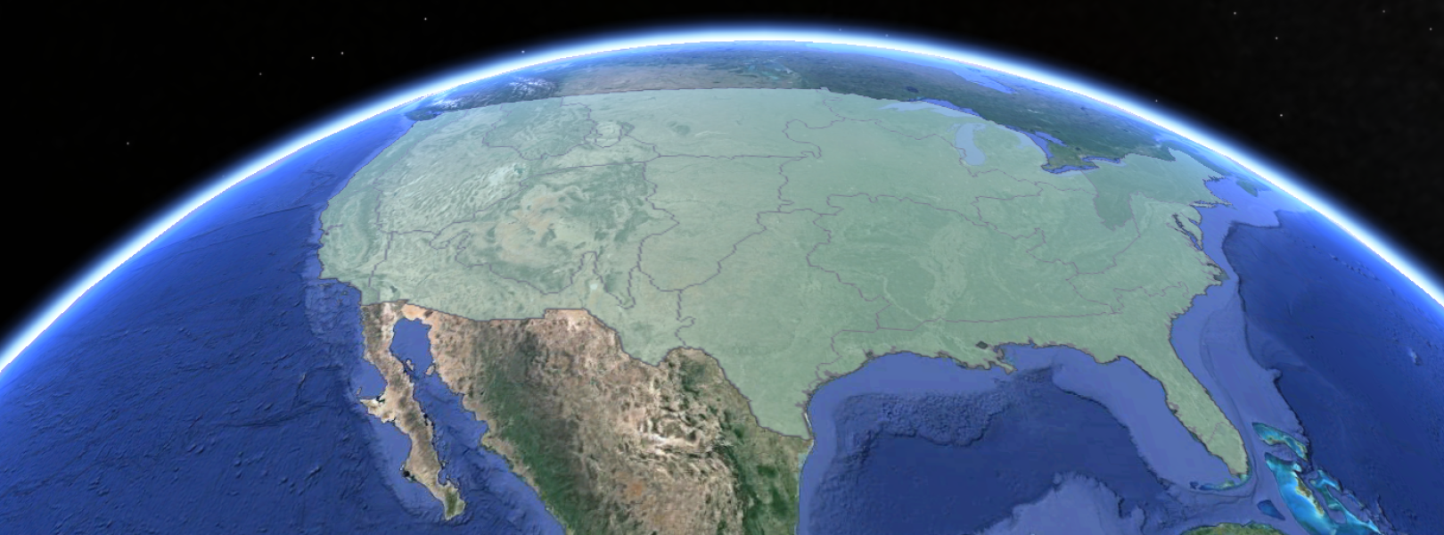
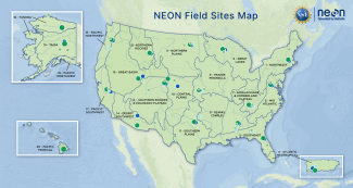
NEON’s ecoclimatic Domain approach strategically determined site locations representative of ecological and climatological conditions. NEON statistically partitioned the continental U.S., Hawaii, and Puerto Rico into 20 ecoclimatic Domains that represent distinct regions of vegetation, landforms, and ecosystem dynamics to capture the full range of U.S. ecological and climatic diversity. In each Domain, NEON collects data about plants, animals, soil, nutrients, freshwater, and the atmosphere using sensor measurements and field observations.

NEON field-based measurements provide detailed information that characterizes local, site-level change. Airborne data combined with site-level data capture contiguous site-level information and can be combined with existing satellite data to support regional to continental characterization of ecological processes.

Airborne remote sensing data

NEON uses sensors mounted on an airplane to collect data that characterizes ecological conditions continuously over the entire area of its field sites. These airborne data, combined with site-level measurements that often represent smaller plots, are used to estimate vegetation height, density, health, and even leaf chemistry across entire NEON sites and regions. These site-level NEON data products support the study of ecological change across disparate ecosystems throughout the U.S.

Measurements at multiple scales

Scaling information from NEON sites to the continental U.S., Hawaii, and Puerto Rico presents considerable challenges that must be addressed through systematic sampling within a framework of multi-scaled observations, analysis, and modeling. NEON provides opportunities to integrate local to continental-scale measurements that characterize ecological change. For example, NEON 1) measures individual trees at sites and 2) collects remote sensing data that characterize trees and forests over multiple sites. Scientists can integrate these measurements with existing nationwide datasets, such as satellite derived land cover data. Combined, these data provide a more integrated view of carbon flux and vegetation cover over time.

Field-based measurements

At each site, NEON collects biological, chemical, and physical measurements and samples using manual field measurements and calibrated sensors. NEON produces data products that characterize site-level conditions at varying spatial and temporal resolutions. For example, field technicians collect vegetation data that identifies individual tree species and measures vegetation height and density within particular plots. Collected over time, this information can be used to track changes in vegetation structure and composition. NEON site-level observations also offer direct measurements of the ecosystem exchange of energy, water, and carbon at small spatial scales. Site-level estimates of water and carbon fluxes drive models that characterize and predict the responses of global biogeochemical cycles to changing climate and land cover.

Overview data collection figure

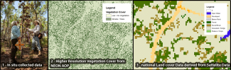
NEON collects measurements at various scales from in situ (1) to higher-resolution airborne (2). NEON's higher-resolution in situ and airborne data can be integrated with existing satellite derived products (3) to create continental datasets.


NSF NEON, Operated by Battelle

Follow Us:

Join Our Newsletter

Get updates on events, opportunities, and how NEON is being used today.

Subscribe Now

Footer

  • About Us
  • Newsroom
  • Contact Us
  • Terms & Conditions
  • Careers
  • Code of Conduct

Copyright © Battelle, 2025

The National Ecological Observatory Network is a major facility fully funded by the U.S. National Science Foundation.

Any opinions, findings and conclusions or recommendations expressed in this material do not necessarily reflect the views of the U.S. National Science Foundation.