Calibrating Soil Sensors? It's a Dirty Job, But We Had To Do It
July 20, 2018
Accurately determining soil moisture can sometimes be tricky because differences in soil composition and structure can lead to lower accuracy of sensor-based measurements. To ensure data quality and consistency across 47 field sites, scientists had to carefully calibrate soil moisture sensors for each unique soil profile. Here's what they did—and why it matters to the NEON community.
Moisture Matters: Why We Measure Soil Moisture Levels
The amount of moisture in the soil is one of the critical variables that influence the overall makeup and diversity of the local ecosystem. The type and abundance of vegetation an ecosystem can support depends heavily on soil moisture patterns. So do fungal and bacterial communities living within the soil and, ultimately, all of the animal populations in the ecosystem. Studying soil moisture also provides insight into hydrological and biogeochemical processes.
Monitoring trends in soil moisture levels across NEON’s terrestrial sites provides data that will help ecologists investigate a broad range of questions, such as:
- How are soil moisture levels changing over time in response to climate change?
- How is soil moisture interrelated with other key indicators, such as temperature?
- How are changes in land use affecting the ability of the soil to retain moisture?
- How does soil type influence moisture retention?
- How do soil moisture levels impact the spread of pathogens or invasive species?
- How are changes in precipitation patterns likely to impact vegetation growth and agricultural yield in different regions?
Answering these and other questions about soil moisture will help scientists build better models to forecast how changes in climate and land use will impact soil moisture patterns and, in turn, many of the processes and organisms that depend on them.
Getting Accurate Measurements for Different Soil Types
There are several different ways to measure soil moisture, each with their own pros and cons. For the NEON project, scientists needed a sensor that could gather accurate and precise data at different depths in a variety of soil types. The sensors would need to be able to collect and transmit data automatically while being left in the field for long periods of time. Under National Science Foundation (NSF) guidelines, they would also need to have the ability to be periodically removed from the field and recalibrated with minimal impact to the surrounding soil.
Based on these requirements, scientists working on the design of the NEON project selected a capacitance-based sensor. These sensors are placed in borehole tubes within the soil and, unlike other sensor types, are not buried directly in the soil. This makes them easy to place and easy to remove for recalibration. The sensors send an electromagnetic signal into the surrounding soil and measure the signal that is reflected back from the soil. This reflected signal provides a measure of the dielectric potential of the soil (the ability of the soil to transmit electricity). Because the magnitudes of dielectric constants of water and dry soil are notably different, measuring the dielectric potential within a volume of soil can provide information about water content.
Previous researchers found that the measurements taken by capacitance sensors are sensitive to variations in soil type. As a result, sensors must be calibrated to each soil type in order to reduce measurement uncertainty and ensure that data are accurate and comparable.
For the NEON project, researchers need to be able to compare data taken across terrestrial field sites in 20 different climate domains, each containing many different combinations of soil types differentiated by chemical composition, physical structure, density, porosity, particle size, pore size and other variables. Before collecting soil moisture data, project scientists needed to find a unique set of calibration coefficients for each site’s soil types.
That's a Whole Lot of Dirt!
Calibrating the soil sensors is a massive (and very dirty) undertaking. Soil collections started in June of 2012 and are still ongoing today.
Staff scientists collect blocks of soil from each site using giant "cookie cutters" (40 cm x 40 cm x 16 cm deep). Up to six soil samples were taken from each NEON field site to ensure good representation across all soil horizons (visibly distinct layers of the soil).
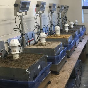
Each soil block was then sent to a lab. To calibrate the sensors, researchers gradually immersed each soil block in a tub of water. The soil block was then allowed to drain under gravity through perforations in the bottom plate until the water was no longer actively dripping out of the bottom plate. This represented the field capacity of the soil, or the amount of water remaining after the rate of downward movement has ceased. A capacitance soil sensor was then placed into a borehole within the block and left there to continuously measure the changing moisture levels as the block dried. The blocks were left to dry until moisture levels approached permanent wilting point, a process called a "dry down." Researchers used raw frequency measurements taken throughout the dry down to calibrate the sensors to each unique soil type. The entire process can take up to six months depending on the soil type under calibration.
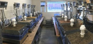
Soil block calibration in a NEON laboratory
Full details of the entire process (collections and calibrations) can be found in a paper published in the Vadose Zone Journal: A Robust Calibration Method for Continental-Scale Soil Water Content Measurements. It represents one of the largest known (quite possibly the largest) soil calibration studies in North America.
Soil-specific calibrations are now complete for 222 blocks from 40 NEON field sites. Soil moisture data from these sites are also available on the NEON Data Portal. Calibrations for the remaining sites are expected to be complete by the end of 2018.
Monitoring Soil Moisture Trends on a Continental Scale
The NEON project is the first to provide standardized soil moisture data on a continental scale in North America. Carefully calibrating the capacitance-type sensors to each soil type within each NEON field site allows for accurate (< 3.5% error) monitoring of soil moisture, making it usable for a broad range of ecological research, modeling and forecasting projects.
The ability to compare soil moisture data between sites and across the continent will enable ecologists to investigate large-scale ecological questions, such as how soil moisture levels impact the carbon storage potential of an ecosystem. Other potential uses include looking at habitat traits that are favored by rodents that are implicated in the spread of Hantavirus or examining how soil moisture, temperature and other factors impact seed germination after a forest fire. A better understanding of how soil moisture is interrelated with other ecological variables could enable better land management planning, agricultural forecasting and climate change modeling.
Soil moisture data are freely available via the NEON Data Portal. Researchers can also request archival samples of soil collected at the NEON field sites.