NSF NEON, Operated by Battelle

Main navigation

  • About
    • NEON Overview
      • Vision and Management
      • Spatial and Temporal Design
      • History
    • About the NEON Biorepository
      • ASU Biorepository Staff
      • Contact the NEON Biorepository
    • Observatory Blog
    • Newsletters
    • Staff
    • FAQ
    • Contact Us

    About

  • Data
    • Data Portal
      • Data Availability Charts
      • API & GraphQL
      • Prototype Data
      • Externally Hosted Data
    • Data Collection Methods
      • Airborne Observation Platform (AOP)
      • Instrument System (IS)
        • Instrumented Collection Types
        • Aquatic Instrument System (AIS)
        • Terrestrial Instrument System (TIS)
      • Observational System (OS)
        • Observation Types
        • Observational Sampling Design
        • Sampling Schedules
        • Taxonomic Lists Used by Field Staff
        • Optimizing the Observational Sampling Designs
      • Protocols & Standardized Methods
    • Getting Started with NEON Data
      • neonUtilities for R and Python
      • Learning Hub
      • Code Hub
    • Using Data
      • Data Formats and Conventions
      • Released, Provisional, and Revised Data
      • Data Product Bundles
      • Usage Policies
      • Acknowledging and Citing NEON
      • Publishing Research Outputs
    • Data Notifications
    • NEON Data Management
      • Data Availability
      • Data Processing
      • Data Quality

    Data

  • Samples & Specimens
    • Biorepository Sample Portal at ASU
    • About Samples
      • Sample Types
      • Sample Repositories
      • Megapit and Distributed Initial Characterization Soil Archives
    • Finding and Accessing Sample Data
      • Species Checklists
      • Sample Explorer - Relationships and Data
      • Biorepository API
    • Requesting and Using Samples
      • Loans & Archival Requests
      • Usage Policies

    Samples & Specimens

  • Field Sites
    • Field Site Map and Info
    • Spatial Layers & Printable Maps

    Field Sites

  • Resources
    • Getting Started with NEON Data
    • Research Support Services
      • Field Site Coordination
      • Letters of Support
      • Mobile Deployment Platforms
      • Permits and Permissions
      • AOP Flight Campaigns
      • Research Support FAQs
      • Research Support Projects
    • Code Hub
      • neonUtilities for R and Python
      • Code Resources Guidelines
      • Code Resources Submission
      • NEON's GitHub Organization Homepage
    • Learning Hub
      • Tutorials
      • Workshops & Courses
      • Science Videos
      • Teaching Modules
    • Science Seminars and Data Skills Webinars
    • Document Library
    • Funding Opportunities

    Resources

  • Impact
    • Research Highlights
    • Papers & Publications
    • NEON in the News

    Impact

  • Get Involved
    • Upcoming Events
    • Research and Collaborations
      • Environmental Data Science Innovation and Inclusion Lab
      • Collaboration with DOE BER User Facilities and Programs
      • EFI-NEON Ecological Forecasting Challenge
      • NEON Great Lakes User Group
      • NCAR-NEON-Community Collaborations
    • Advisory Groups
      • Science, Technology & Education Advisory Committee
      • Technical Working Groups
    • NEON Ambassador Program
      • Exploring NEON-Derived Data Products Workshop Series
    • Partnerships
    • Community Engagement
    • Work Opportunities

    Get Involved

  • My Account
  • Search

Search

About

  • NEON Overview
  • About the NEON Biorepository
  • Observatory Blog
  • Newsletters
  • Staff
  • FAQ
  • Contact Us

Breadcrumb

  1. About
  2. Observatory Blog
  3. AOP Lidar Data Quality Notification

Data Notification

AOP Lidar Data Quality Notification

September 29, 2022

AOP lidar data products collected with the Optech Galaxy Prime Lidar sensor between 2021 and 2022 were found to have abnormally high noise levels, which our standard noise filtering algorithms did not correctly classify. The tables below summarize the affected data products, and the sites and publication months with affected data. Most of the data affected are available provisionally, although two sites released in RELEASE-2022 (MOAB 2021 and MLBS 2021) were also affected.

The figure below displays examples of the noise that remains in the point cloud data. The noise-related artifacts are clearly identifiable when differencing the Canopy Height Model contained in the Ecosystem Structure (DP3.30015.001) data product between two subsequent visits. In the image to the right below, the noise issues are most prevalent in the north-east corner, where the bright red areas are located, indicating there was a large difference observed in tree heights between subsequent years. The issue has variable severity depending partly on the atmospheric conditions during the time of acquisition, and does not generally affect the entire site. Note that the majority of affected sites are still viable.

aop point cloud and canopy height models

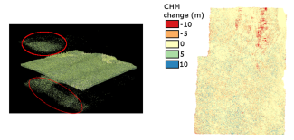
Left: Colorized point cloud showing some of the atmospheric noise still remaining within highlighted regions. Right: Difference between Canopy Height Models (in meters) collected in 2021 and 2020 at the D17 site TEAK. Red areas in the northern area highlight where noise was mis-classified.

The AOP science team is currently working with Teledyne Optech to resolve this issue, and the lidar data will be re-processed. The issue is expected to be corrected in RELEASE-2023 for the data sets included in RELEASE-2022. Provisional data will be updated as soon as the noise artifacts have been eliminated. Previously released data containing the noise artifacts will still be available on the data portal until the corrected data is published.

Please use the Contact Us form for further inquiries regarding this issue, and include the term "INC0059048" in the body of your request.

Table 1: Affected data products

Data Product ID Data Product Name
DP1.30003.001 Discrete return LiDAR point cloud
DP3.30024.001 Elevation - LiDAR
DP3.30025.001 Slope and Aspect - LiDAR
DP3.30015.001 Ecosystem structure
DP1.30001.001 LiDAR slant range waveform

Table 2: Affected sites and years

Domain Site Publish Year-Month Release Status
D13 MOAB 2021-04 RELEASE-2022
D07 GRSM 2021-06 PROVISIONAL
D07 MLBS 2021-06 RELEASE-2022
D17 SOAP 2021-07 PROVISIONAL
D17 TEAK 2021-07 PROVISIONAL
D16 ABBY 2021-07 PROVISIONAL
D16 WREF 2021-07 PROVISIONAL
D16 MCRA 2021-07 PROVISIONAL
D02 SCBI 2021-08 PROVISIONAL
D02 BLAN 2021-08 PROVISIONAL
D02 SERC 2021-08 PROVISIONAL
D03 JERC 2021-09 PROVISIONAL
D03 OSBS 2021-09 PROVISIONAL
D03 DSNY 2021-09 PROVISIONAL
D11 CLBJ 2022-05 PROVISIONAL
D11 PRIN 2022-05 PROVISIONAL
D11 OAES 2022-05 PROVISIONAL
D02 BLAN 2022-05 PROVISIONAL
D02 SCBI 2022-05 PROVISIONAL
D02 SERC 2022-05 PROVISIONAL

Share

Related Posts:

AOP Data Availability Notification – Release 2026

December 15, 2025

Pilot Results and Updated Methodology - mosquito pathogen status (DP1.10041.001)

October 30, 2025

Version 1.2.0 of neonutilities Python package released

October 29, 2025

NSF NEON, Operated by Battelle

Follow Us:

Join Our Newsletter

Get updates on events, opportunities, and how NEON is being used today.

Subscribe Now

Footer

  • About Us
  • Contact Us
  • Terms & Conditions
  • Careers
  • Code of Conduct

Copyright © Battelle, 2026

The National Ecological Observatory Network is a major facility fully funded by the U.S. National Science Foundation.

Any opinions, findings and conclusions or recommendations expressed in this material do not necessarily reflect the views of the U.S. National Science Foundation.