NSF NEON, Operated by Battelle

Main navigation

  • About Us
    • Overview
      • Spatial and Temporal Design
      • History
    • Vision and Management
    • Advisory Groups
      • Science, Technology & Education Advisory Committee
      • Technical Working Groups (TWGs)
    • FAQ
    • Contact Us
      • Contact NEON Biorepository
      • Field Offices
    • User Accounts
    • Staff
    • Code of Conduct

    About Us

  • Data & Samples
    • Data Portal
      • Explore Data Products
      • Data Availability Charts
      • Spatial Data & Maps
      • Document Library
      • API & GraphQL
      • Prototype Data
      • External Lab Data Ingest (restricted)
    • Data Themes
      • Biogeochemistry
      • Ecohydrology
      • Land Cover and Processes
      • Organisms, Populations, and Communities
    • Samples & Specimens
      • Discover and Use NEON Samples
        • Sample Types
        • Sample Repositories
        • Sample Explorer
        • Megapit and Distributed Initial Characterization Soil Archives
      • Sample Processing
      • Sample Quality
      • Taxonomic Lists
    • Collection Methods
      • Protocols & Standardized Methods
      • Airborne Remote Sensing
        • Flight Box Design
        • Flight Schedules and Coverage
        • Daily Flight Reports
          • AOP Flight Report Sign Up
        • Camera
        • Imaging Spectrometer
        • Lidar
      • Automated Instruments
        • Site Level Sampling Design
        • Sensor Collection Frequency
        • Instrumented Collection Types
          • Meteorology
          • Phenocams
          • Soil Sensors
          • Ground Water
          • Surface Water
      • Observational Sampling
        • Site Level Sampling Design
        • Sampling Schedules
        • Observation Types
          • Aquatic Organisms
            • Aquatic Microbes
            • Fish
            • Macroinvertebrates & Zooplankton
            • Periphyton, Phytoplankton, and Aquatic Plants
          • Terrestrial Organisms
            • Birds
            • Ground Beetles
            • Mosquitoes
            • Small Mammals
            • Soil Microbes
            • Terrestrial Plants
            • Ticks
          • Hydrology & Geomorphology
            • Discharge
            • Geomorphology
          • Biogeochemistry
          • DNA Sequences
          • Pathogens
          • Sediments
          • Soils
            • Soil Descriptions
        • Optimizing the Observational Sampling Designs
    • Data Notifications
    • Data Guidelines and Policies
      • Acknowledging and Citing NEON
      • Publishing Research Outputs
      • Usage Policies
    • Data Management
      • Data Availability
      • Data Formats and Conventions
      • Data Processing
      • Data Quality
      • Data Product Bundles
      • Data Product Revisions and Releases
        • Release 2021
        • Release 2022
        • Release 2023
        • Release 2024
        • Release-2025
      • NEON and Google
      • Externally Hosted Data

    Data & Samples

  • Field Sites
    • About Field Sites and Domains
    • Explore Field Sites
    • Site Management Data Product

    Field Sites

  • Impact
    • Observatory Blog
    • Case Studies
    • Papers & Publications
    • Newsroom
      • NEON in the News
      • Newsletter Archive
      • Newsletter Sign Up

    Impact

  • Resources
    • Getting Started with NEON Data & Resources
    • Documents and Communication Resources
      • Papers & Publications
      • Document Library
      • Outreach Materials
    • Code Hub
      • Code Resources Guidelines
      • Code Resources Submission
      • NEON's GitHub Organization Homepage
    • Learning Hub
      • Science Videos
      • Tutorials
      • Workshops & Courses
      • Teaching Modules
    • Research Support Services
      • Field Site Coordination
      • Letters of Support
      • Mobile Deployment Platforms
      • Permits and Permissions
      • AOP Flight Campaigns
      • Research Support FAQs
      • Research Support Projects
    • Funding Opportunities

    Resources

  • Get Involved
    • Advisory Groups
      • Science, Technology & Education Advisory Committee
      • Technical Working Groups
    • Upcoming Events
    • NEON Ambassador Program
      • Exploring NEON-Derived Data Products Workshop Series
    • Research and Collaborations
      • Environmental Data Science Innovation and Inclusion Lab
      • Collaboration with DOE BER User Facilities and Programs
      • EFI-NEON Ecological Forecasting Challenge
      • NEON Great Lakes User Group
      • NEON Science Summit
      • NCAR-NEON-Community Collaborations
        • NCAR-NEON Community Steering Committee
    • Community Engagement
      • How Community Feedback Impacts NEON Operations
    • Science Seminars and Data Skills Webinars
      • Past Years
    • Work Opportunities
      • Careers
      • Seasonal Fieldwork
      • Internships
        • Intern Alumni
    • Partners

    Get Involved

  • My Account
  • Search

Search

Field Sites

  • About Field Sites and Domains
  • Explore Field Sites
  • Site Management Data Product

Breadcrumb

  1. Field Sites
  2. Bartlett Experimental Forest NEON

Field Site

Bartlett Experimental Forest NEON / BART

brown circle white drop icon

Gradient Terrestrial, NH, D01: Northeast

About Field Sites

Bartlett Experimental Forest (BART) is a terrestrial NEON field site located within the Saco River Valley of the White Mountain National Forest in Carroll County, New Hampshire. The 15.66 km2 (3870 acre) site is hosted by the U.S. Forest Service. The site’s soils, elevational gradient, climate, and tree species composition are typical for many forested areas throughout New England. BART also represents the most northeastern NEON site and anchors the top of the north-south nitrogen deposition gradient along the eastern side of the U.S. BART is located in the Northeast Domain (D01), which encompasses the New England and northern Eastern Seaboard states along with the northern end of the Appalachian range. D01 includes one other terrestrial site and one aquatic site. [1] [3]

Climate

The local climate of the Bartlett Experimental Forests consists of relatively warm summers with temperatures above 32°C (89°F) and cold winters with temperatures reaching -5°C (23°F). Average annual mean temperature is 6.2°C and average annual precipitation is 1270 mm (50 in.). Elevation differences from 200 m (680 ft.) to 900 m (3000 ft.) greatly affect localized climate. It is not uncommon for higher elevations to accumulate more than 600 mm (23.6 in.) of snow during one storm. [1] [2] [6]

Geology

BART is made up of White Mountain Plutonic-Volcanic Succession bedrock. The parent materials at BART are mostly ablation till, lodgment till, melt-out till, and supraglacial till derived from conway granite and gneiss. [4] [5] [7]

Soils

The soils at BART are spodosols within the subgroup Aquic Haplorthods. They developed on glacial till derived from granite and gneiss. The major soil series on the site include Marlow, Monadnock, and Danforth. The soils are moist, but relatively well-drained. The soil organic horizon under the forest canopy ranges between 3-30 cm in thickness. [1] [4] [5]

Hydrology

Due to the geology of the White Mountain National Forests, most of the locations are well drained. However, lower elevation locations may be slightly less effective at water drainage. [3]

Vegetation

Climate and glacial till soil make BART an ideal area for old-growth northern deciduous hardwoods consisting of beech (Fagus sp.) and sugar maple (Acer saccarum). White pines (Pinus strobus) are dispersed throughout the site but are primarily found in lower elevations. Softwood trees such as hemlock (Tsuga canadensis), balsam fir (Abies balsamea), and spruce are frequently found on cool steep slopes or in lower elevations with poor drainage. [3]

Fauna

Typical wildlife found in the White Mountains include white-tailed deer, moose, red and gray fox, black bear, snowshoe hare, raccoon, coyote, Canadian lynx, river otter, mink, and porcupine. Notable bird species include bald eagle, peregrine falcon, ruffled grouse, and Becknell's thrush. [2]

Past Land Management and Use

Like other areas throughout the northeast, the White Mountains where BART is located have a history of logging through the late 19th century and into the early 20th. The timber industry selectively logged the area for high-value species, built logging railroads, and cut down hardwood stands for fuel. The majority of the forest was managed for logging; however, some portions of the lower forest were cleared for pasture, and higher elevation sections were left wild. Fires were infrequent throughout the past century, but the Great New England Hurricane of 1938 is notably responsible for widespread damage to the forest. The Bartlett Experimental Forest was officially established as a research station in 1931 by Congress. The first 50 years of research focused on forest dynamics and management, ecological relationships of wildlife, and preservation. [2]

Current Land Management and Use

The land is actively managed by the USDA Forest Service. Northeastern Forest Service scientists and faculty and graduate students from the University of New Hampshire contribute greatly to the current research in the Bartlett Experimental Forest. Research areas include but are not limited to long-term succession studies, habitat studies, clearcutting and shelterwood studies, stocking, remote sensing, songbirds, bats, small mammals, and salamander. More recently, remote sensing has become an area of increased interest with cooperation among Forest Service, University of New Hampshire and NASA scientists. Ongoing research completed at Bartlett drives many of the management decisions for northeastern hardwood forests. [1] [2]

NEON Site Establishment

The Domain 01 support facility in Fitchburg, MA was constructed in June 2013. Terrestrial observational sampling at BART began in October 2014, but plot establishment (the process of selecting, ground-truthing and building out plots) was not completed until November 2015. The instrumentation tower was not fully complete until December 2016. The 2006 National Land Cover Database (NLCD) was selected for stratification because of the consistent and comparable data availability across the United States. TOS Tower Plots were allocated according to a spatially balanced design in and around the NEON tower airshed.

Additional Resources

  1. USDA Forest Service Northeastern Research Station. 1998. Bartlett Experimental Forest
  2. Adams, Mary Beth; Loughry, Linda; Plaugher, Linda, comps. 2004. Experimental Forests and Ranges of the USDA Forest Service. Gen. Tech. Rep. NE-321. Newtown Square, PA: U.S. Department of Agriculture, Forest Service, Northeastern Research Station. 178 p.
  3. Terrestrial Observation System (TOS) Site Characterization Report: Domain 01. NEON.DOC.003884vB
  4. Philippe, Jessica; Stuart, Martha (2016). NEON Site Level Plot Summary: Bartlett Experimental Forest (BART), July 2016
  5. Michael SanClements, Robert H Lee, E D Ayres, Keli Goodman, Morgan Jones, David Durden, Katherine Thibault, Rommel Zulueta, Joshua Roberti, Claire Lunch, Adrian Gallo, Collaborating with NEON, BioScience, Volume 70, Issue 2, February 2020, Page 107, https://doi.org/10.1093/biosci/biaa005
  6. PRISM Climate Group, Oregon State University
  7. U.S. Geological Survey, 2005, Mineral Resources Data System: U.S. Geological Survey, Reston, Virginia.

Field Site Information

Latitude/Longitude

44.063889, -71.287375

Geodetic Datum

WGS84

Location

Carroll County
NH, US

Elevation

Mean: 274m
Minimum: 230m
Maximum: 655m

Mean Annual Temperature

6.2°C

Dominant Wind Direction

S

Mean Canopy Height

23.0m

Dominant NLCD Classes

Deciduous Forest, Evergreen Forest, Mixed Forest

Colocated Research

Bartlett Experimental Forest
University of New Hampshire
Ameriflux
Critical Zone Exploration Network

Field Operations Office

166 Boulder Drive, Suite 101
Fitchburg, MA 01420

Research Access

Non-NEON research activities are allowed in this area. Researchers must obtain their own permits with the site host(s).

Request Access

Observation Types

Remote Sensing

Remote sensing surveys of this field site collect lidar, spectrometer and high-resolution RGB camera data.

Meteorological Measurements

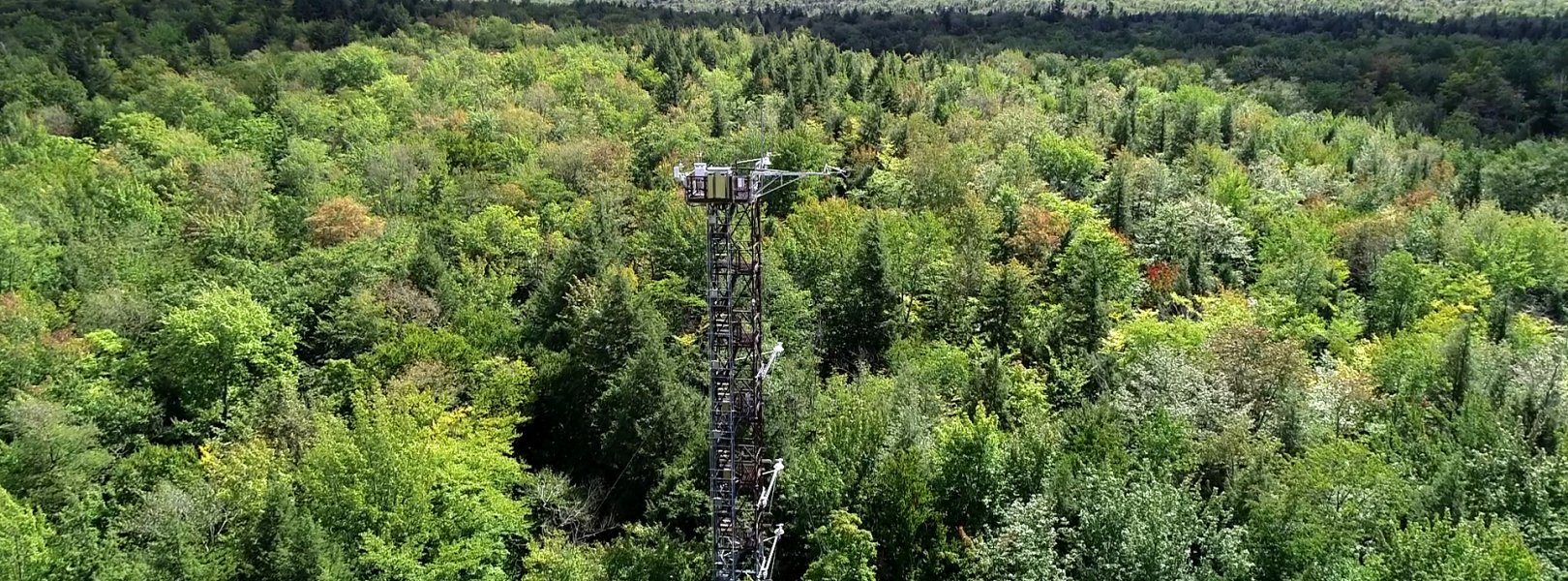
This site has a flux/meteorological tower that is 35 m (115 ft) tall with six measurement levels. The tower top extends above the vegetation canopy to allow sensors mounted at the top and along the tower to capture the full profile of atmospheric conditions from the top of the vegetation canopy to the ground. The tower collects physical and chemical properties of atmosphere-related processes, such as humidity, wind, and net ecosystem gas exchange. Precipitation data are collected by a tipping bucket at the top of the tower and a series of throughfalls located in the soil array.

Phenocams

One phenocam is attached to the top and the bottom of the tower. Here we show the images from the most recent hour. The full collection of images can be viewed on the Phenocam Gallery - click on either of the images below.

Tower top

NEON.D01.BART.DP1.10033

Tower bottom

NEON.D01.BART.DP1.10042

Soil Sensor Measurements

This site has five soil plots placed in an array within the airshed of the flux tower. Photosynthetically Active Radiation (PAR) at soil surface, soil heat flux, solar radiation, and throughfall are measured at the soil surface in each soil plot. Soil moisture, soil temperature, and CO2 concentration are measured at multiple depths in each soil plot.

Observational Sampling

At terrestrial sites, field ecologists observe birds and plants, and sample ground beetles, mosquitoes, small mammals, soil microbes, and ticks. Lab analyses are carried out to provide further data on DNA sequences, pathogens, soils, sediments, and biogeochemistry. Learn more about terrestrial observations or explore this site's data products.


Field Site Data

Site

Site Host

White Mountain National Forest, U.S. Forest Service (Northern Research Station)

Site Access Allowed

Yes

Site URL

https://www.nrs.fs.fed.us/ef/locations/nh/bartlett/

Site Access Details

Bartlett Experimental Forest has very limited staff and the USFS personnel are NOT available to support external researchers. Permitting requests for research activities should be submitted at least 6 months prior to planned start.

Operations Office

NEON Field Operations Office

Domain 01 Support Facility

NEON Field Operations Address

166 Boulder Drive, Suite 101
Fitchburg, MA 01420

NEON Field Operations Phone

978.627.4010

Location

Latitude

44.063889

Longitude

-71.287375

Geodetic Datum

WGS84

UTM Northing

4881511.55m

UTM Easting

316812.16m

UTM Zone

19N

County

Carroll

State

NH

Country

US

Mean Elevation

274m

Minimum Elevation

230m

Maximum Elevation

655m

Climate

Mean Annual Temperature

6.2°C

Mean Annual Precipitation

1325mm

Dominant Wind Direction

S

Vegetation

Mean Canopy Height

23.0m

Dominant NLCD Classes

Deciduous Forest, Evergreen Forest, Mixed Forest

Average number of green days

180

Average first greenness increase date

120 DOY

Average peak green date

170 DOY

Average first greenness decrease date

220 DOY

Average minimum greenness date

300 DOY

Tower

Tower Height

35m

Number of Tower Levels

6

Soils

Megapit Soil Family

Coarse-loamy - isotic - frigid Aquic Haplorthods

Soil Subgroup

Aquic Haplorthods


Gallery

  • Photos
  • Videos

Related Field Sites

Other Domain D01 Field Sites

brown square white mountain icon Harvard Forest & Quabbin Watershed NEON
Core Terrestrial
blue square white drop icon Lower Hop Brook NEON
Core Aquatic
NSF NEON, Operated by Battelle

Follow Us:

Join Our Newsletter

Get updates on events, opportunities, and how NEON is being used today.

Subscribe Now

Footer

  • About Us
  • Newsroom
  • Contact Us
  • Terms & Conditions
  • Careers
  • Code of Conduct

Copyright © Battelle, 2025

The National Ecological Observatory Network is a major facility fully funded by the U.S. National Science Foundation.

Any opinions, findings and conclusions or recommendations expressed in this material do not necessarily reflect the views of the U.S. National Science Foundation.