NSF NEON, Operated by Battelle

Main navigation

  • About Us
    • Overview
      • Spatial and Temporal Design
      • History
    • Vision and Management
    • Advisory Groups
      • Science, Technology & Education Advisory Committee
      • Technical Working Groups (TWGs)
    • FAQ
    • Contact Us
      • Contact NEON Biorepository
      • Field Offices
    • User Accounts
    • Staff
    • Code of Conduct

    About Us

  • Data & Samples
    • Data Portal
      • Explore Data Products
      • Data Availability Charts
      • Spatial Data & Maps
      • Document Library
      • API & GraphQL
      • Prototype Data
      • External Lab Data Ingest (restricted)
    • Data Themes
      • Biogeochemistry
      • Ecohydrology
      • Land Cover and Processes
      • Organisms, Populations, and Communities
    • Samples & Specimens
      • Discover and Use NEON Samples
        • Sample Types
        • Sample Repositories
        • Sample Explorer
        • Megapit and Distributed Initial Characterization Soil Archives
      • Sample Processing
      • Sample Quality
      • Taxonomic Lists
    • Collection Methods
      • Protocols & Standardized Methods
      • Airborne Remote Sensing
        • Flight Box Design
        • Flight Schedules and Coverage
        • Daily Flight Reports
          • AOP Flight Report Sign Up
        • Camera
        • Imaging Spectrometer
        • Lidar
      • Automated Instruments
        • Site Level Sampling Design
        • Sensor Collection Frequency
        • Instrumented Collection Types
          • Meteorology
          • Phenocams
          • Soil Sensors
          • Ground Water
          • Surface Water
      • Observational Sampling
        • Site Level Sampling Design
        • Sampling Schedules
        • Observation Types
          • Aquatic Organisms
            • Aquatic Microbes
            • Fish
            • Macroinvertebrates & Zooplankton
            • Periphyton, Phytoplankton, and Aquatic Plants
          • Terrestrial Organisms
            • Birds
            • Ground Beetles
            • Mosquitoes
            • Small Mammals
            • Soil Microbes
            • Terrestrial Plants
            • Ticks
          • Hydrology & Geomorphology
            • Discharge
            • Geomorphology
          • Biogeochemistry
          • DNA Sequences
          • Pathogens
          • Sediments
          • Soils
            • Soil Descriptions
        • Optimizing the Observational Sampling Designs
    • Data Notifications
    • Data Guidelines and Policies
      • Acknowledging and Citing NEON
      • Publishing Research Outputs
      • Usage Policies
    • Data Management
      • Data Availability
      • Data Formats and Conventions
      • Data Processing
      • Data Quality
      • Data Product Bundles
      • Data Product Revisions and Releases
        • Release 2021
        • Release 2022
        • Release 2023
        • Release 2024
        • Release-2025
      • NEON and Google
      • Externally Hosted Data

    Data & Samples

  • Field Sites
    • About Field Sites and Domains
    • Explore Field Sites
    • Site Management Data Product

    Field Sites

  • Impact
    • Observatory Blog
    • Case Studies
    • Papers & Publications
    • Newsroom
      • NEON in the News
      • Newsletter Archive
      • Newsletter Sign Up

    Impact

  • Resources
    • Getting Started with NEON Data & Resources
    • Documents and Communication Resources
      • Papers & Publications
      • Document Library
      • Outreach Materials
    • Code Hub
      • Code Resources Guidelines
      • Code Resources Submission
      • NEON's GitHub Organization Homepage
    • Learning Hub
      • Science Videos
      • Tutorials
      • Workshops & Courses
      • Teaching Modules
    • Research Support Services
      • Field Site Coordination
      • Letters of Support
      • Mobile Deployment Platforms
      • Permits and Permissions
      • AOP Flight Campaigns
      • Research Support FAQs
      • Research Support Projects
    • Funding Opportunities

    Resources

  • Get Involved
    • Advisory Groups
      • Science, Technology & Education Advisory Committee
      • Technical Working Groups
    • Upcoming Events
    • NEON Ambassador Program
      • Exploring NEON-Derived Data Products Workshop Series
    • Research and Collaborations
      • Environmental Data Science Innovation and Inclusion Lab
      • Collaboration with DOE BER User Facilities and Programs
      • EFI-NEON Ecological Forecasting Challenge
      • NEON Great Lakes User Group
      • NEON Science Summit
      • NCAR-NEON-Community Collaborations
        • NCAR-NEON Community Steering Committee
    • Community Engagement
      • How Community Feedback Impacts NEON Operations
    • Science Seminars and Data Skills Webinars
      • Past Years
    • Work Opportunities
      • Careers
      • Seasonal Fieldwork
      • Internships
        • Intern Alumni
    • Partners

    Get Involved

  • My Account
  • Search

Search

Field Sites

  • About Field Sites and Domains
  • Explore Field Sites
  • Site Management Data Product

Breadcrumb

  1. Field Sites
  2. Lenoir Landing NEON

Field Site

Lenoir Landing NEON / LENO

brown circle white drop icon

Gradient Terrestrial, AL, D08: Ozarks Complex

View of LENO tower from a drone

About Field Sites

The Lenoir Landing site (LENO) is a terrestrial field site located located in southwest Alabama near Butler, AL in Choctaw county. The 58 km2 (14,349 acre) site is colocated with the 17 km2 (4218 acre) Choctaw National Wildlife Refuge and Lenoir Landing Park. Lenoir Landing Park hosts the flux tower and tower plots and is managed by the U.S. Army Corps of Engineers. The distributed plots are located 5 km (3 mi.) south of the tower shed on the Choctaw National Wildlife Refuge managed by the U.S. Fish and Wildlife Service. The site is characterized by hardwood bottomland with seasonal flooding and is located along the Tombigbee River. This site is part of NEON's Ozarks Complex Domain (D08). D08 includes two other terrestrial field sites and three aquatic field sites. LENO is colocated with the Lower Tombigbee River aquatic site (TOMB). [2] [4] [5]

Climate

Alabama has a subtropical climate with hot summers, mild winters, and year-round precipitation. Summers are hot and humid, dominated by maritime tropical air from the Gulf of Mexico and the Atlantic. This warm, moist air contributes to the formation of convection storms and thunderstorms in the region, causing major precipitation pulses in the Tombigbee River Basin. The area is subject to tornadoes and hurricanes. The mean average annual temperature is 18.1°C (64.6°F) and the region averages about 1385 mm (55 in.) of precipitation annually. [1] [6] [9]

Geology

The parent materials at LENO are primarily Holocene-aged alluvial deposits, with the upstream source of the alluvium mainly Eocene-aged materials from the Wilcox and Claiborne groups. Coastal and terrace deposits are also found on the site. [4] [7]

Soils

Soils at LENO are in the soil subgroup Vertic Epiaquepts, which are characterized as fine, mixed, active, acid, and thermic. The major soil series on the site include Urbo, Mooreville, and Una, with minor extents of Riverview and Mantachie on higher positions. [4]

Hydrology

LENO is located within the Tombigbee River basin, which is encompassed within the Mobile River Basin. The 35656 km2 (8.8 million acre) basin straddles the border between Alabama and Mississippi. The Tombigbee River gathers the flow from four major rivers: the Buttahatchee, Noxubee, and Sucarnoochee from the west, and the Sipsey from the northeast. The main branch of the river flows from northeastern Mississippi to western Alabama, where it joins with the Black Warrior River, then eventually drains into the Mobile River. The flow in the Tombigbee River is generally regulated by locks and dams. The Tombigbee River Basin is subject to major precipitation pulses from tropical storms and hurricanes. These major events affect nutrient and organic matter flux, sediment transport, and biota along the gradient as they propagate downstream. [6]

Vegetation

The vegetation around LENO is dominated by closed-canopy pine-oak mixed forest, and also includes meadows and wetlands. Pine trees are typically found in higher, relatively less flooded areas, while oaks are distributed throughout the whole area, including the lower land with standing water. Some common species found in the canopy include a broad mix of cypress (Taxodium spp.), black gum (Nyssa sylvatica), shagbark hickory (Carya ovata), oaks, and green ash (Fraxinus pennsylvanica). Ground cover includes bamboo, grass, smilax and poison ivy (Toxicodendrom radicans). [5] [6]

Fauna

Alabama hosts many different species due to its diverse ecosystems. These include 62 native mammal species, over 400 bird species, 73 amphibian species, and a plethora of invertebrate species. NEON collects data on birds, ground beetles, mosquitoes, small mammals, and ticks at the LENO site. [8]

Past Land Management and Use

The Tombigbee River Basin was primarily settled by the Choctaws when European explorers and settlers arrived in the 1600s. The Choctaws and Chickasaws surrendered their claims to all territory on the eastern side of the Tombigbee in 1816 and the Choctaws later ceded their lands west of the Tombigbee in 1830. Following the 1830 Indian Removal Act, the U.S. government used forced treaties to relocate the Cherokee, Choctaw, Chickasaw, and Creek off the land. The Corps of Engineers first surveyed the river in 1870 to implement a series of locks and dams. The Coffeeville Lock and Dam in Choctaw County was completed in the early 1960s. In 1964, the Choctaw National Wildlife Refuge was established; it is bordered on the east by the Tombigbee River, which is a part of the property obtained by the U.S. Army Corps of Engineers for the Coffeeville Lock and Dam project. The refuge is still maintained today to provide habitat for breeding waterfowl. [2] [10] [13] [14]

Current Land Management and Use

Currently the Choctaw National Wildlife Refuge, which hosts the LENO site, is managed with the goal of increasing production of migratory waterfowl, particularly wood duck (Aix sponsa). The refuge has seven moist soil impoundments that are drained in the summer to allow the growth of food plants for the waterfowl. Crops such as millet and winter wheat also add to the foraging opportunities for wildlife. The refuge also hosts over 400 artificial wood duck nesting boxes to supplement natural nesting locations. It is estimated that 2500 wood ducks are hatched in these boxes each year. The refuge also uses selective timber harvesting to encourage growth of new hardwood and herbaceous growth. Lenoir Landing Park is managed as a recreational area by the U.S. Army Corps of Engineers and provides recreational activities such as boating, camping, and fishing. [2] [3] [12]

NEON Site Establishment

NEON began plot establishment of the LENO site in November 2015. Construction of the 45 m (148 ft.) instrumentation tower was completed in August 2016 and began streaming data at that time. Terrestrial sampling and observations were fully launched in late September 2016. [6]

Additional Resources

[1] https://statesummaries.ncics.org/chapter/al/

[2] Choctaw: About the Refuge (2018, April 16) U.S. Fish and Wildlife Service. Retrieved April 30, 2020, from https://www.fws.gov/refuge/Choctaw/about.html

[3] Choctaw: Resource Management (April 16, 2018). U.S. Fish and Wildlife Service. Retrieved May 5, 2020, from https://www.fws.gov/refuge/Choctaw/what_we_do/resource_management.html

[4] NEON Site-Level Plot Summary, Lenoir Landing (LENO), August 2018. https://data.neonscience.org/documents/10179/2361410/LENO_Soil_SiteSumm…

[5] Terrestrial Observation System (TOS) Site Characterization Report: Domain 08. NEON.DOC.003892vB

[6] Aquatic Instrument System (AIS) Site Characterization Report: Domain 08. NEON.DOC.001370vB

[7] U.S. Geological Survey, 2005, Mineral Resources Data System: U.S. Geological Survey, Reston, Virginia. https://mrdata.usgs.gov/mrds/

[8] Outdoor Alabama: Watchable Wildlife. Alabama Department of Conservation and Natural Resources. Retrieved May 5, 2020, from https://www.outdooralabama.com/watchable-wildlife

[9] PRISM Climate Group., Oregon State University, http://prism.oregonstate.edu, created 4 Feb 2004.

[10] National Park Service: https://www.nps.gov/articles/the-trail-of-tears-and-the-forced-relocati…

[11] http://www.adem.state.al.us/programs/water/nps/files/TombigbeeBMP.pdf

[12] https://www.sam.usace.army.mil/Missions/Civil-Works/Recreation/Black-Wa…

[13] USFWS: https://www.fws.gov/southeast/pdf/brochure/choctaw-national-wildlife-re…

[14] Doster, J. F., & Weaver, D. C. (1981). Historic Settlement in the Upper Tombigbee Valley. Alabama University in Birmingham Center for the Study of Southern History and Culture.

Field Site Information

Latitude/Longitude

31.853861, -88.161181

Geodetic Datum

WGS84

Location

Choctaw County
AL, US

Elevation

Mean: 13m

Mean Annual Temperature

18.1°C

Dominant Wind Direction

N

Mean Canopy Height

35.0m

Dominant NLCD Classes

Deciduous Forest, Woody Wetlands

Colocated Site(s)

Lower Tombigbee River NEON

Colocated Research

Choctaw National Wildlife Refuge
Critical Zone Exploration Network
Ameriflux

Field Operations Office

6050 Mimosa Circle, Suite C
Tuscaloosa, AL 35405

Research Access

Non-NEON research activities are allowed in this area. Researchers must obtain their own permits with the site host(s).

Request Access

Observation Types

Remote Sensing

Remote sensing surveys of this field site collect lidar, spectrometer and high-resolution RGB camera data.

Meteorological Measurements

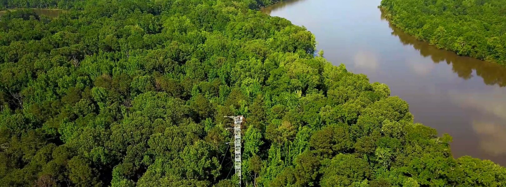
This site has a flux/meteorological tower that is 47 m (154 ft) tall with six measurement levels. The tower top extends above the vegetation canopy to allow sensors mounted at the top and along the tower to capture the full profile of atmospheric conditions from the top of the vegetation canopy to the ground. The tower collects physical and chemical properties of atmosphere-related processes, such as humidity, wind, and net ecosystem gas exchange. Precipitation data are collected by a tipping bucket at the top of the tower and a series of throughfalls located in the soil array.

Phenocams

One phenocam is attached to the top and the bottom of the tower. Here we show the images from the most recent hour. The full collection of images can be viewed on the Phenocam Gallery - click on either of the images below.

Tower top

NEON.D08.LENO.DP1.10033

Tower bottom

NEON.D08.LENO.DP1.10042

Soil Sensor Measurements

This site has five soil plots placed in an array within the airshed of the flux tower. Photosynthetically Active Radiation (PAR) at soil surface, soil heat flux, solar radiation, and throughfall are measured at the soil surface in each soil plot. Soil moisture, soil temperature, and CO2 concentration are measured at multiple depths in each soil plot.

Observational Sampling

At terrestrial sites, field ecologists observe birds and plants, and sample ground beetles, mosquitoes, small mammals, soil microbes, and ticks. Lab analyses are carried out to provide further data on DNA sequences, pathogens, soils, sediments, and biogeochemistry. Learn more about terrestrial observations or explore this site's data products.


Field Site Data

Site

Site Host

US Fish and Wildlife Service

Site Access Allowed

Yes

Site URL

https://www.fws.gov/refuge/choctaw/

Site Access Details

The primary purpose of the refuge is to provide wood duck brood habitat and serve as a protected wintering area for waterfowl. Researchers should coordinate directly with site manager.

Site Host

US Army Corps of Engineers

Site Access Allowed

Limited

Site URL

https://www.sam.usace.army.mil/

Site Access Details

This area is primarily intended to provide recreational opportunities and is also classified as a hunting area. As such, access is very limited but potentially possible.

Operations Office

NEON Field Operations Office

Domain 08 Support Facility

NEON Field Operations Address

6050 Mimosa Circle, Suite C
Tuscaloosa, AL 35405

NEON Field Operations Phone

205.409.9039

Location

Latitude

31.853861

Longitude

-88.161181

Geodetic Datum

WGS84

UTM Northing

3524827.17m

UTM Easting

390139.62m

UTM Zone

16N

County

Choctaw

State

AL

Country

US

Mean Elevation

13m

Climate

Mean Annual Temperature

18.1°C

Mean Annual Precipitation

1386mm

Dominant Wind Direction

N

Vegetation

Mean Canopy Height

35.0m

Dominant NLCD Classes

Deciduous Forest, Woody Wetlands

Average number of green days

265

Average first greenness increase date

70 DOY

Average peak green date

145 DOY

Average first greenness decrease date

200 DOY

Average minimum greenness date

335 DOY

Tower

Tower Height

47m

Number of Tower Levels

6

Soils

Megapit Soil Family

Fine - mixed - active - acid - thermic Vertic Epiaquepts

Soil Subgroup

Vertic Epiaquepts


Gallery

  • Photos
  • Videos

Related Field Sites

Other Domain D08 Field Sites

blue circle white drop icon Black Warrior River NEON
Gradient Aquatic
brown circle white drop icon Dead Lake NEON
Gradient Terrestrial
blue circle white drop icon Lower Tombigbee River NEON
Gradient Aquatic
blue square white drop icon Mayfield Creek NEON
Core Aquatic
brown square white mountain icon Talladega National Forest NEON
Core Terrestrial

Other Field Sites in AL

blue circle white drop icon Black Warrior River NEON
Gradient Aquatic
brown circle white drop icon Dead Lake NEON
Gradient Terrestrial
blue circle white drop icon Lower Tombigbee River NEON
Gradient Aquatic
blue square white drop icon Mayfield Creek NEON
Core Aquatic
brown square white mountain icon Talladega National Forest NEON
Core Terrestrial
NSF NEON, Operated by Battelle

Follow Us:

Join Our Newsletter

Get updates on events, opportunities, and how NEON is being used today.

Subscribe Now

Footer

  • About Us
  • Newsroom
  • Contact Us
  • Terms & Conditions
  • Careers
  • Code of Conduct

Copyright © Battelle, 2025

The National Ecological Observatory Network is a major facility fully funded by the U.S. National Science Foundation.

Any opinions, findings and conclusions or recommendations expressed in this material do not necessarily reflect the views of the U.S. National Science Foundation.