Treehaven NEON (TREE) Soil Descriptions
Distributed Soils Reports
Pedon Descriptions
Pit‐level observations and field measurements reported using the standard NRCS format. They contain volume estimates for coarse fragments > 20 mm where applicable.
Site Level Plot Summary
A narrative summary that places the sampled soil pedons in the broader context of soils and geomorphology for the entire NEON site.
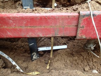
Megapit Images
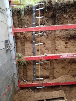
D05 TREE megapit soil profile 0-200 cm
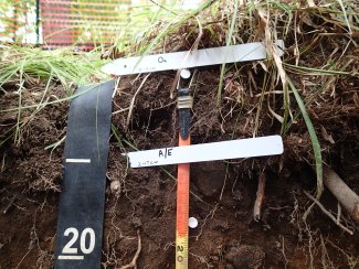
D05 TREE megapit soil profile 0-21 cm
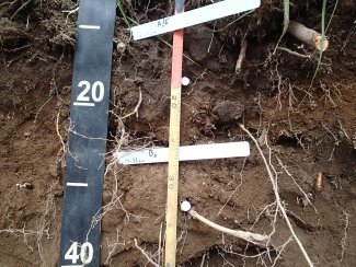
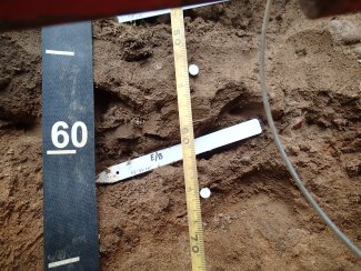
D05 TREE megapit soil profile 7-40 cm
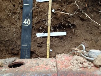
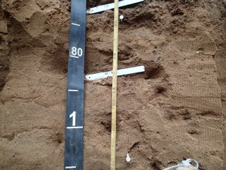
D05 TREE megapit soil profile 28-56 cm
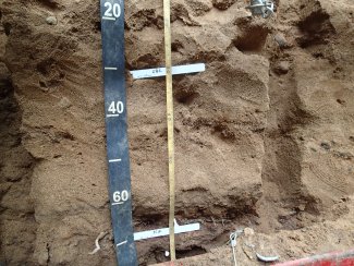
D05 TREE megapit soil profile 47-72 cm
D05 TREE megapit soil profile 63-110 cm
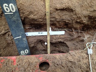
D05 TREE megapit soil profile 116-178 cm
D05 TREE megapit soil profile 156-183 cm
D05 TREE megapit soil profile 167-200 cm
Megapit Pedon Description
| Print Date | Feb 18 2016 |
|---|---|
| Description Date | Jun 17 2015 |
| Describer | Mark Krupinski, Lilly Palmer |
| Site ID | 2015WI069002 |
| Pedon ID | 2015WI069002 |
| Lab Source ID | KSSL |
| Lab Pedon # | 15N0684 |
| Soil Name as Correlated | Padwet |
| Classification | Coarse-loamy, mixed, superactive, frigid Alfic Haplorthods |
| Pedon Type | undefined observation |
| Pedon Purpose | ecological site data |
| Taxon Kind | series |
| Geomorphic Setting | on backslope of moraine on pitted outwash plain |
| Upslope Shape | convex |
| Cross Slope Shape | linear |
| Description origin | NASIS |
| Country | United States |
| State | Wisconsin |
| County | Lincoln |
| MLRA | 94D -- Northern Highland Sandy Drift |
| Soil Survey Area | 10-RHI -- Rhinelander, Wisconsin |
| Map Unit | PeB -- Pence-Padus sandy loams, 1 to 6 percent slopes |
| Std Latitude | 45.4926944 |
| Std Longitude | -89.5875000 |
| Latitude | 45 degrees 29 minutes 33.70 seconds north |
| Longitude | 89 degrees 35 minutes 15.00 seconds west |
| Datum | NAD83 |
| Primary Earth Cover | Tree cover |
| Secondary Earth Cover | Intermixed conifers and hardwoods |
| Existing Vegetation | alternateleaf dogwood, balsam fir, bearded shorthusk, eastern white pine, hemlock, ironwood, paper birch, partridgeberry, Pennsylvania sedge, red maple, starflower, sugar maple, twistedstalk, wood anemone |
| Parent Material | sandy and loamy outwash over sandy and gravelly outwash over sandy and gravelly till |
| Surface Fragments | 0.0 percent nonflat subrounded indurated 250- to 600-millimeter mixed rock fragments |
| Description database | KSSL |
| Diagnostic Features | ochric epipedon 0 to 17 cm. spodic horizon 17 to 33 cm. albic horizon 33 to 52 cm. glossic horizon 52 to 66 cm. lamellae 66 to 107 cm. densic materials 168 to 200 cm. |
| Top Depth (cm) | 168 |
| Bottom Depth | 200 |
| Restriction Kind | densic material |
| Slope (%) | 6.0 |
| Elevation (meters) | 471.8 |
| Aspect (deg) | 185 |
| Drainage Class | moderately well |
| Horizon Details |
Oa--0 to 2 centimeters (0.0 to 0.8 inches); very dark gray (7.5YR 3/1) highly decomposed plant material; moderate very fine granular structure; very friable; very fine roots and fine roots; very strongly acid, pH 4.9, Hellige-Truog; abrupt broken boundary. Lab sample # 15N03505. 40 percent O horizon - patchy 75 percent charcoal A/E--2 to 17 centimeters (0.8 to 6.7 inches); dark brown (7.5YR 3/2) sandy loam; moderate fine granular structure; friable; very fine roots and fine roots and coarse roots; 10 percent nonflat subrounded indurated 2 to 72-millimeter mixed rock fragments; strongly acid, pH 5.4, Hellige-Truog; clear wavy boundary. Lab sample # 15N03506. A/E is mixed by earthworms Bs--17 to 33 centimeters (6.7 to 13.0 inches); brown (7.5YR 4/4) sandy loam; weak medium subangular blocky structure; friable; very fine roots and fine roots and coarse roots; 10 percent nonflat subrounded indurated 2 to 72-millimeter mixed rock fragments; strongly acid, pH 5.5, Hellige-Truog; clear wavy boundary. Lab sample # 15N03507. ~ 5 percent A horizon material mixed by earthwormns E--33 to 52 centimeters (13.0 to 20.5 inches); brown (7.5YR 4/3) sandy loam; weak medium subangular blocky structure; friable; very fine roots and medium roots and fine roots; 12 percent nonflat subrounded indurated 2 to 72-millimeter mixed rock fragments; strongly acid, pH 5.5, Hellige-Truog; gradual wavy boundary. Lab sample # 15N03508 E/B--52 to 66 centimeters (20.5 to 26.0 inches); brown (7.5YR 4/3) and reddish brown (5YR 4/4) gravelly sandy loam; weak medium prismatic parts to moderate medium subangular blocky structure; firm; very fine roots and fine roots; 30 percent faint 5YR 3/4), moist, clay films on all faces of peds; 22 percent nonflat subrounded indurated 2 to 72-millimeter mixed rock fragments; strongly acid, pH 5.4, Hellige-Truog; abrupt irregular boundary. Lab sample # 15N03509 2E and Bt--66 to 107 centimeters (26.0 to 42.1 inches); 80 percent brown (7.5YR 4/3) and 20 percent reddish brown (5YR 4/4) sand, loamy sand; structureless single grain; loose; and 10 percent faint 5YR 3/4), moist, clay bridges between sand grains; 1 percent fine faint 5YR 4/6), moist, masses of oxidized iron; 7 percent nonflat subrounded indurated 2 to 72-millimeter mixed rock fragments; moderately acid, pH 5.6, Hellige-Truog; gradual smooth boundary. Lab sample # 15N03510. 4 lamellae 4-30 mm thick 10 percent cos (stratification) 2BC--107 to 168 centimeters (42.1 to 66.1 inches); brown (7.5YR 5/4) stratified coarse sand to sand; structureless single grain; loose; 1 percent medium distinct 2.5YR 4/6), moist, masses of oxidized iron; 14 percent nonflat subrounded indurated 2 to 72-millimeter mixed rock fragments; moderately acid, pH 5.7, Hellige-Truog; abrupt wavy boundary. Lab sample # 15N03511 3Cd1--168 to 176 centimeters (66.1 to 69.3 inches); yellowish red (5YR 4/6) gravelly sandy loam; structureless massive; very friable; very fine roots and fine roots and coarse roots; 5 percent medium distinct 7.5YR 4/6), moist, masses of oxidized iron; 26 percent nonflat subrounded indurated 2 to 72-millimeter mixed rock fragments; strongly acid, pH 5.1, Hellige-Truog; abrupt wavy boundary. Lab sample # 15N03512 3Cd2--176 to 200 centimeters (69.3 to 78.7 inches); reddish brown (5YR 4/3) gravelly loamy sand; massive parts to weak extremely coarse platy; very friable; 25 percent coarse distinct 2.5YR 4/6), moist, masses of oxidized iron and 25 percent coarse prominent 7.5YR 5/1), moist, masses of reduced iron; 26 percent nonflat subrounded indurated 2 to 72-millimeter mixed rock fragments; strongly acid, pH 5.5, Hellige-Truog. Lab sample # 15N03513. |
Credits: This megapit soil pedon description was generously created by USDA Natural Resource Conservation Service staff, with particular thanks to Larry West, Jon Hempel, and numerous field staff.