NSF NEON, Operated by Battelle

Main navigation

  • About
    • NEON Overview
      • Vision and Management
      • Spatial and Temporal Design
      • History
    • About the NEON Biorepository
      • ASU Biorepository Staff
      • Contact the NEON Biorepository
    • Observatory Blog
    • Newsletters
    • Staff
    • FAQ
    • Contact Us

    About

  • Data
    • Data Portal
      • Data Availability Charts
      • API & GraphQL
      • Prototype Data
      • Externally Hosted Data
    • Data Collection Methods
      • Airborne Observation Platform (AOP)
      • Instrument System (IS)
        • Instrumented Collection Types
        • Aquatic Instrument System (AIS)
        • Terrestrial Instrument System (TIS)
      • Observational System (OS)
        • Observation Types
        • Observational Sampling Design
        • Sampling Schedules
        • Taxonomic Lists Used by Field Staff
        • Optimizing the Observational Sampling Designs
      • Protocols & Standardized Methods
    • Getting Started with NEON Data
      • neonUtilities for R and Python
      • Learning Hub
      • Code Hub
    • Using Data
      • Data Formats and Conventions
      • Released, Provisional, and Revised Data
      • Data Product Bundles
      • Usage Policies
      • Acknowledging and Citing NEON
      • Publishing Research Outputs
    • Data Notifications
    • NEON Data Management
      • Data Availability
      • Data Processing
      • Data Quality

    Data

  • Samples & Specimens
    • Biorepository Sample Portal at ASU
    • About Samples
      • Sample Types
      • Sample Repositories
      • Megapit and Distributed Initial Characterization Soil Archives
    • Finding and Accessing Sample Data
      • Species Checklists
      • Sample Explorer - Relationships and Data
      • Biorepository API
    • Requesting and Using Samples
      • Loans & Archival Requests
      • Usage Policies

    Samples & Specimens

  • Field Sites
    • Field Site Map and Info
    • Spatial Layers & Printable Maps

    Field Sites

  • Resources
    • Getting Started with NEON Data
    • Research Support Services
      • Field Site Coordination
      • Letters of Support
      • Mobile Deployment Platforms
      • Permits and Permissions
      • AOP Flight Campaigns
      • Research Support FAQs
      • Research Support Projects
    • Code Hub
      • neonUtilities for R and Python
      • Code Resources Guidelines
      • Code Resources Submission
      • NEON's GitHub Organization Homepage
    • Learning Hub
      • Tutorials
      • Workshops & Courses
      • Science Videos
      • Teaching Modules
    • Science Seminars and Data Skills Webinars
    • Document Library
    • Funding Opportunities

    Resources

  • Impact
    • Research Highlights
    • Papers & Publications
    • NEON in the News

    Impact

  • Get Involved
    • Upcoming Events
    • Research and Collaborations
      • Environmental Data Science Innovation and Inclusion Lab
      • Collaboration with DOE BER User Facilities and Programs
      • EFI-NEON Ecological Forecasting Challenge
      • NEON Great Lakes User Group
      • NCAR-NEON-Community Collaborations
    • Advisory Groups
      • Science, Technology & Education Advisory Committee
      • Technical Working Groups
    • NEON Ambassador Program
      • Exploring NEON-Derived Data Products Workshop Series
    • Partnerships
    • Community Engagement
    • Work Opportunities

    Get Involved

  • My Account
  • Search

Search

Breadcrumb

  1. Data Collection Methods
  2. Soils
  3. Soil Descriptions
  4. Marvin Klemme Range Research Station NEON (OAES) Soil Descriptions

Marvin Klemme Range Research Station NEON (OAES) Soil Descriptions

Distributed Soils Reports

Pedon Descriptions

Pit‐level observations and field measurements reported using the standard NRCS format. They contain volume estimates for coarse fragments > 20 mm where applicable.

Download

Site Level Plot Summary

A narrative summary that places the sampled soil pedons in the broader context of soils and geomorphology for the entire NEON site.

Download

Megapit Image

soil profile

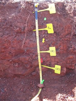
D11 OAES megapit soil profile 0-46 cm

Print Date Jul 22 2015
Description Date Feb 19 2013
Describer Tyson G. Morley
Site ID S2013OK149001
Pedon ID S2013OK149001
Lab Source ID SSL
Lab Pedon # 13N2558
Pedon Purpose research site
Taxon Kind series
Geomorphic Setting on backslope of None Assigned
Upslope Shape convex
Cross Slope Shape convex
Particle Size Control Section 0 to 20 cm.
Country United States
State Oklahoma
County Washita
MLRA 78C -- Central Rolling Red Plains, Eastern Part
Soil Survey Area OK149 -- Washita County, Oklahoma
Std Latitude 35.4105883
Std Longitude -99.0604367
Latitude 35 degrees 24 minutes 38.12 seconds north
Longitude 99 degrees 3 minutes 37.57 seconds west
Datum WGS84
UTM Zone 14
UTM Easting 494513 meters
UTM Northing 3918579 meters
Primary Earth Cover Grass/herbaceous cover
Secondary Earth Cover Savanna rangeland
Existing Vegetation broom snakeweed, curlycup gumweed, plantain, prairie threeawn, pricklypear
Bedrock Kind siltstone
Bedrock Hardness very strongly cemented
Description database KSSL
Diagnostic Features ochric epipedon 0 to 8 cm.
paralithic contact 20 to 46 cm.
lithic contact 46 to cm.
Top Depth (cm) 20
Bottom Depth (cm) 46
Restriction Kind bedrock, paralithic
Restriction Hardness moderately cemented
Top Depth (cm) 46
Bottom Depth (cm)  
Restriction Kind bedrock, lithic
Restriction Hardness very strongly cemented
Slope (%) 4.5
Elevation (meters) 515.0
Aspect (deg) 320
MAAT (C) 15.0
Frost-Free Days 211
Horizon Details

A--0 to 8 centimeters (0.0 to 3.1 inches); dark reddish brown (2.5YR 3/4) silt loam, reddish brown (2.5YR 4/4), dry; 14 percent sand; 58 percent silt; 18 percent clay; strong fine granular structure; loose, loose, slightly sticky, slightly plastic; many very fine roots throughout and common fine roots throughout; 2 percent nonflat angular weakly cemented 2 to 25-millimeter siltstone fragments; very slight effervescence, by HCl, 1 normal; clear smooth boundary. Lab sample # 13N03208

Bw--8 to 20 centimeters (3.1 to 7.9 inches); reddish brown (2.5YR 4/4) extremely gravelly silt loam, reddish brown (2.5YR 4/4), dry; 14 percent sand; 58 percent silt; 18 percent clay; weak fine granular structure; loose, loose, slightly sticky, slightly plastic; many very fine roots throughout and common fine roots throughout; 90 percent nonflat angular weakly cemented 2 to 20-millimeter siltstone fragments; slight effervescence, by HCl, 1 normal; abrupt smooth boundary. Lab sample # 13N03209

Cr1--20 to 31 centimeters (7.9 to 12.2 inches); red (2.5YR 4/6), red (2.5YR 4/6), dry; many very fine roots in cracks; strong effervescence, by HCl, 1 normal; clear smooth boundary. Lab sample # 13N03210

Cr2--31 to 46 centimeters (12.2 to 18.1 inches); red (2.5YR 4/6), red (2.5YR 4/6), dry; many very fine roots in cracks; strong effervescence, by HCl, 1 normal; abrupt smooth boundary. Lab sample # 13N03211

R--46 centimeters (18.1 inches); strong effervescence, by HCl, 1 normal.

Credits: This megapit soil pedon description was generously created by USDA Natural Resource Conservation Service staff, with particular thanks to Larry West, Jon Hempel, and numerous field staff.

NSF NEON, Operated by Battelle

Follow Us:

Join Our Newsletter

Get updates on events, opportunities, and how NEON is being used today.

Subscribe Now

Footer

  • About Us
  • Contact Us
  • Terms & Conditions
  • Careers
  • Code of Conduct

Copyright © Battelle, 2026

The National Ecological Observatory Network is a major facility fully funded by the U.S. National Science Foundation.

Any opinions, findings and conclusions or recommendations expressed in this material do not necessarily reflect the views of the U.S. National Science Foundation.