NSF NEON, Operated by Battelle

Main navigation

  • About
    • NEON Overview
      • Vision and Management
      • Spatial and Temporal Design
      • History
    • About the NEON Biorepository
      • ASU Biorepository Staff
      • Contact the NEON Biorepository
    • Observatory Blog
    • Newsletters
    • Staff
    • FAQ
    • Contact Us

    About

  • Data
    • Data Portal
      • Data Availability Charts
      • API & GraphQL
      • Prototype Data
      • Externally Hosted Data
    • Data Collection Methods
      • Airborne Observation Platform (AOP)
      • Instrument System (IS)
        • Instrumented Collection Types
        • Aquatic Instrument System (AIS)
        • Terrestrial Instrument System (TIS)
      • Observational System (OS)
        • Observation Types
        • Observational Sampling Design
        • Sampling Schedules
        • Taxonomic Lists Used by Field Staff
        • Optimizing the Observational Sampling Designs
      • Protocols & Standardized Methods
    • Getting Started with NEON Data
      • neonUtilities for R and Python
      • Learning Hub
      • Code Hub
    • Using Data
      • Data Formats and Conventions
      • Released, Provisional, and Revised Data
      • Data Product Bundles
      • Usage Policies
      • Acknowledging and Citing NEON
      • Publishing Research Outputs
    • Data Notifications
    • NEON Data Management
      • Data Availability
      • Data Processing
      • Data Quality

    Data

  • Samples & Specimens
    • Biorepository Sample Portal at ASU
    • About Samples
      • Sample Types
      • Sample Repositories
      • Megapit and Distributed Initial Characterization Soil Archives
    • Finding and Accessing Sample Data
      • Species Checklists
      • Sample Explorer - Relationships and Data
      • Biorepository API
    • Requesting and Using Samples
      • Loans & Archival Requests
      • Usage Policies

    Samples & Specimens

  • Field Sites
    • Field Site Map and Info
    • Spatial Layers & Printable Maps

    Field Sites

  • Resources
    • Getting Started with NEON Data
    • Research Support Services
      • Field Site Coordination
      • Letters of Support
      • Mobile Deployment Platforms
      • Permits and Permissions
      • AOP Flight Campaigns
      • Research Support FAQs
      • Research Support Projects
    • Code Hub
      • neonUtilities for R and Python
      • Code Resources Guidelines
      • Code Resources Submission
      • NEON's GitHub Organization Homepage
    • Learning Hub
      • Tutorials
      • Workshops & Courses
      • Science Videos
      • Teaching Modules
    • Science Seminars and Data Skills Webinars
    • Document Library
    • Funding Opportunities

    Resources

  • Impact
    • Research Highlights
    • Papers & Publications
    • NEON in the News

    Impact

  • Get Involved
    • Upcoming Events
    • Research and Collaborations
      • Environmental Data Science Innovation and Inclusion Lab
      • Collaboration with DOE BER User Facilities and Programs
      • EFI-NEON Ecological Forecasting Challenge
      • NEON Great Lakes User Group
      • NCAR-NEON-Community Collaborations
    • Advisory Groups
      • Science, Technology & Education Advisory Committee
      • Technical Working Groups
    • NEON Ambassador Program
      • Exploring NEON-Derived Data Products Workshop Series
    • Partnerships
    • Community Engagement
    • Work Opportunities

    Get Involved

  • My Account
  • Search

Search

About

  • NEON Overview
  • About the NEON Biorepository
  • Observatory Blog
  • Newsletters
  • Staff
  • FAQ
  • Contact Us

Breadcrumb

  1. About
  2. Observatory Blog
  3. NEON Airborne Observation Platform Takes Flight Again

NEON Airborne Observation Platform Takes Flight Again

June 13, 2024

Photo of plane landing at Boulder airport

It’s that time of the year: The NEON Airborne Observation Platform (AOP) has begun the 2024 airborne remote sensing season. Each year between March and October, the aircraft perform survey flights over a subset of the NEON field sites. Here are some fun facts about the AOP and some photos taken by the AOP teams during previous remote sensing surveys.

This year, surveys will be conducted at field sites representing 10 NEON Domains, including the Northeast (D01), Southeast (D03), Great Lakes (D05), Prairie Peninsula (D06), Ozarks Complex (D08), Central Plains (D10), Southern Plains (D11), Southern Rockies/Colorado Plateau (D13), Pacific Southwest (D17), and Taiga (D19). See the full 2024 Airborne Operations Schedule here.

Remote Sensing FAQs

What Is the NEON Airborne Operation Platform?

The NEON AOP consists of remote sensing instrument packages carried by a Twin Otter aircraft. NEON operates three payloads that include:

  • Discrete and full-waveform lidar
  • An imaging spectrometer
  • A high-resolution digital camera

Together, these instruments provide a rich and detailed characterization of the landscape, with data products that can be used to understand the three-dimensional structure of vegetation, land cover types, chemical content of vegetation, and much more.

When Is Remote Sensing Conducted?

Remote sensing data are collected over both terrestrial and aquatic field sites at peak greenness—the time of year when vegetation is at its most lush and verdant. This period varies across different regions of the United States due to differences in climate, elevation, and local ecosystems. In general, southern locations reach peak greenness earlier than northern locations, and higher elevations experience leaf-out and greenness later than lower elevations. The flight schedules are carefully planned months in advance to catch each Domain at its greenest.

How Often Are NEON Field Sites Surveyed by the AOP?

Remote sensing data are collected at field sites in the continental U.S. and Alaska at a minimum of three out of every five years and in Puerto Rico and Hawaii every five years.

Where Can I Find Remote Sensing Data?

In the NEON Data Portal, of course! The AOP produces 29 NEON data products from the three sensors, including Lidar (discrete return lidar point cloud data, lidar slant range waveform, ecosystem structure (CHM), elevation, slope and aspect), Spectrometer (at-sensor radiance, surface reflectance, albedo, fPAR, LAI, canopy water indices, and vegetation indices), and Camera (high-res orthorectified camera imagery). In Spring of 2024, the AOP started generating topographic and BRDF-corrected surface reflectance for sites collected in 2022 and after, and derived reflectance data products (eg. the L2 and L3 indices) will now be derived from these bidirectional reflectance data. For information on this new bidirectional dataset, and the differences, please refer to the tutorial “Introduction to Bidirectional Hyperspectral Reflectance Data in Python.”

This Is Pretty Cool—Can I Request a flight survey?

Yes! The AOP payloads are available on a cost-recoverable basis as part of our research support services. Two of the AOP payloads are used for field site surveys each year, while the third is reserved as a backup for NEON operations or for Assignable Assets Program requests. Contact us to learn more!

A View from the Sky

Here are a few great photos taken by our AOP teams during past remote sensing seasons.

Domain 01: Northeast 

BART from the air

A view near the BART field site in Domain 01.

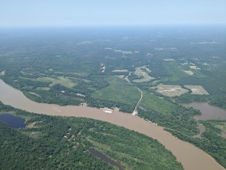
Domain 03: Southeast

JERC from the air

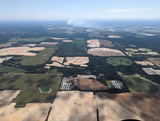
Smoke from a controlled burn at the JERC field site can be seen from the air.

Domain 05: Great Lakes

UNDE from the air

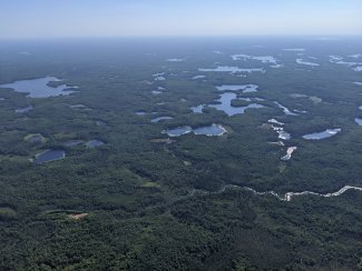
The abundant lakes near the UNDE field site as seen from the plane.

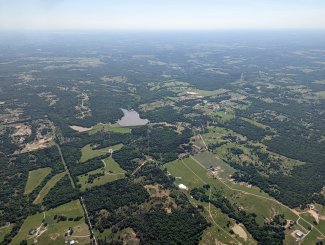
Domain 06: Prairie Peninsula

KONA and KONZ from the air

The lands around KONA and KONZ.

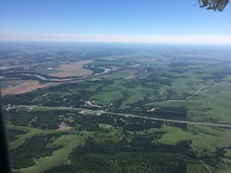
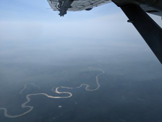
Domain 08: Ozarks Complex

LENO from the air

A wide river snakes by the LENO field site in Domain 08, Alabama.

Cam Chapman sets up GPS

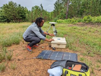
Cam Chapman sets up the GPS for the AOP team at TALL.

Domain 10: Central Plains

Calibration flight

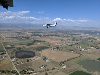
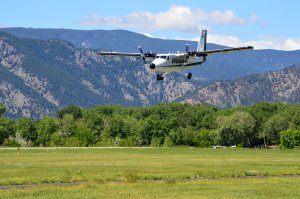
A Twin Otter aircraft flies near Boulder, CO.

Boulder Flatiron smoke

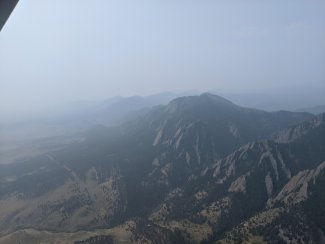
Smoke clings to the Boulder Flatirons during a calibration flight.

Domain 11: Southern Plains

CLBJ from the air

Peak greenness at the CLBJ site in Texas, Domain 11.

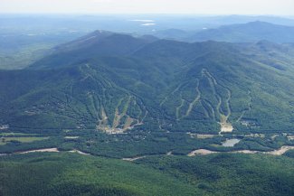
Domain 13: Southern Rockies and Colorado Plateau

NIWO from the air

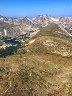
On the front range, the NIWO site reaches nearly 12,000 ft.

transit over Colorado Rockies on way to Moab

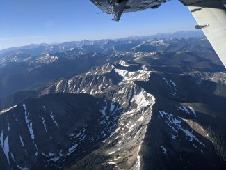
Flying by some Colorado Rocky peaks during transit to Moab.

Domain 17: Pacific Southwest

Sunset on the sierras

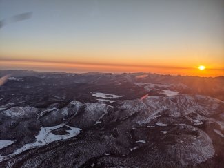
Sunset viewed from the AOP over the California Sierras.

TEAK from above

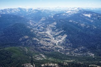
The TEAK field site in Domain 17 from the air.

Domain 19: Alaska Taiga

Smoke over Fairbanks

Smoke over Fairbanks, Alaska in Domain 19.

BONA from the air

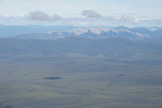
View of distant Alaskan mountains behind the BONA field site during an AOP survey.

Share

Related Posts:

Discontinuation of Select NEON Data Products

January 29, 2026

Resolved: NEON AOP Lidar Data Quality Issues Due to Mis-Classified Atmospheric Noise

January 23, 2026

AOP Data Availability Notification – Release 2026

December 15, 2025

NSF NEON, Operated by Battelle

Follow Us:

Join Our Newsletter

Get updates on events, opportunities, and how NEON is being used today.

Subscribe Now

Footer

  • About Us
  • Contact Us
  • Terms & Conditions
  • Careers
  • Code of Conduct

Copyright © Battelle, 2026

The National Ecological Observatory Network is a major facility fully funded by the U.S. National Science Foundation.

Any opinions, findings and conclusions or recommendations expressed in this material do not necessarily reflect the views of the U.S. National Science Foundation.