Data Notification
Minor Artifacts in Reflectance Data and Google Earth Engine Data Updates
March 18, 2026
NEON’s Airborne Observation Platform (AOP) has several updates to share with the community, including: 1) Discovering a minor bug that resulted in spectral anomalies for a small percentage of pixels in radiance and reflectance datasets, and 2) New data additions and updates to the AOP remote sensing image collections on Google Earth Engine.
All updates are detailed below:
1) A minor bug resulted in spectral anomalies in BRDF-corrected reflectance data and minor anomalies related to incomplete masking of Bad Detector Elements
A rare numerical instability in the Bidirectional Reflectance Distribution Function (BRDF) correction was recently discovered, primarily affecting pixels with low signal to noise ratios. The issue resulted in anomalous spikes in the spectral curve and affects a small percentage of pixels (typically under 3%) for each site. The affected pixels primarily occur in shadowed regions or dark water bodies that are characterized by low reflectance signals. AOP scientists have implemented an additional masking routine to remove these pixels from the BRDF correction, which will correct these anomalies in future data processing.
See Figure 1 below for an example of the anomalous pixels (shown in red) in an image of Wind River Experimental Forest NEON (WREF) field site.
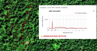
Figure 1: Top: Zoomed in RGB reflectance image of 2022 WREF showing pixels with spectral anomalies shown in red and an example spectral signature of one of the anomalous pixels. Bottom: Spectral anomalies shown in a zoomed-out view of the site.
In addition, some of the older (pre-2022) reflectance data (both directional and bidirectional), may depict similar spectral artifacts due to improperly handled Bad Detector Elements (BDEs) in the sensor. (See Figure 2 below for an example of how the pattern appears in the data.) This issue also affects a very small percentage of pixels, but may occur in any part of the image, not just areas with low signal to noise ratios. There is a BDE Mask in the L1 Radiance HDF5 files, which can be used to mask out these pixels. During analysis, it is recommended to either mask out these 'bad' pixels, or interpolate across the good pixels surrounding the bad pixels.
In 2025, AOP started using an updated algorithm to convert raw digital numbers to radiance, which made improvements to mask out the BDEs. AOP plans to re-process pre-2025 data with this updated code; see below for the planned timeframe.
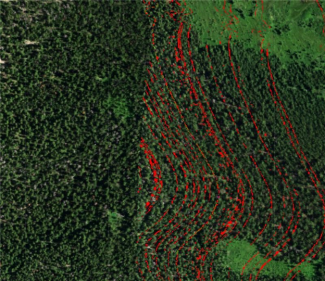
Figure 2: Example of the pattern of anomalous pixels due to Bad Detector Elements in 2020 NIWO reflectance data. Pixels highlighted in red have spectral outliers.
To see where these anomalous pixels occur in the subset of images impacted by these issues, please use this Earth Engine app for displaying and optionally downloading the anomalous pixel masks in geotiff format for the affected images.
Timeline for when the 2022-2025 radiance, reflectance, and derived data will be updated:
Since this issue is relatively minor and we expect that most analyses using the reflectance data would exclude the shaded areas and water bodies, AOP plans to prioritize applying the BRDF and topographic corrections to older (pre-2022) data that is currently only available as directional reflectance. Once that is complete, AOP will re-process the 2022-2025 data to remove the anomalies described. The expected timeline for re-processing the 2022-2025 data to remove these artifacts is mid- to late-2027.
2) Status Updates for AOP Data on Google Earth Engine
AOP has made several updates to the remote sensing datasets available on Google Earth Engine, described below:
• AOP data available on Google Earth Engine (GEE) has been updated to match the 2026 Data Release. Please see the Release 2026 Webpage for more details on what has changed, and the AOP Data Availability Notification - Release 2026 for more details on the AOP updates made for RELEASE-2026. Release status and release year for data on GEE are contained in the PROVISIONAL_RELEASED and RELEASE_YEAR properties for each dataset, so please remember to cite NEON data accessed through GEE accordingly.
• AOP has now added a CITATION property to all of the NEON GEE datasets that provides citation recommendations for NEON data accessed through GEE. For data that has been released, a DOI property is also now populated. See the updated Introduction to AOP Public Datasets in Google Earth Engine (GEE) tutorial for more information on how to view these citation-related properties.
• AOP has added the Canopy Nitrogen Content dataset (CNC, DP3.30018.002) to the GEE data catalog. Please see the recent related Data Notification: New Data Product: Canopy Nitrogen, Subset of Data Available for Community Review for more details on this new dataset, and for information on how to provide feedback. The AOP Earth Engine Data Viewer can also be used to explore this dataset in GEE.
• Lastly, AOP has updated both the desktop and mobile versions of the AOP Earth Engine Data Viewer, including the addition of the Canopy Nitrogen Content L3 data product, the addition of derived terrain products (Slope/Aspect, DP3.30025.001), as well as vegetation indices (DP3.30026.001) derived from the BRDF-corrected reflectance imagery.
For more information on any of these updates, please use the NEON Contact Us Form and include the words "Remote Sensing" or "AOP" and other relevant details in the "Comments/Questions" field.