NEON’s Airborne Remote Sensing Flight Season Announced for 2019
January 29, 2019
Thinking about planning a ground sampling project in coordination with one of our airborne remote sensing surveys? The 2019 NEON flight campaign plans have been announced.
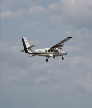
The season will run from March to October, covering fifteen NEON domains and including 35 terrestrial sites and 21 aquatic sites. Data will be collected using a NEON Airborne Observation Platform (AOP). Each AOP consists of an imaging spectrometer, a discrete and waveform light detection and ranging (LIDAR) instrument and a high-resolution digital camera mounted into a DeHavilland DHC-6 Twin Otter aircraft that is flown at a nominal altitude of 1000 m above ground level (AGL) at a speed of 100 knots at NEON field sites. The flight parameters enable meter-scale spectroscopy, decimeter-scale photography, and ~4 points-per-meter discreet and waveform lidar measurements at a sufficient signal-to-noise ratio to retrieve vegetation vertical structure and biogeochemical properties from measured reflectance spectra.
At each terrestrial site a minimum of 100 km2 will be surveyed over an area encompassing the NEON flux tower airsheds and distributed long-term observational sampling plots, representative vegetation types, and watershed boundaries for both terrestrial and aquatics sites. To minimize signal uncertainty due to plant phenology and to ensure spatial and temporal consistency in data products across multiple years, all terrestrial sites are scheduled to be flown during mean peak greenness, defined as the range of dates where MODIS NDVI is within 90% of the site maximum. To minimize atmospheric effects, data acquisition occurs at less than 10% cloud cover.
While preliminary data collection started in 2013, 2019 marks the second year of full operations in which Battelle field scientists follow a standard schedule of collecting remote sensing data from each site on a rotating basis for the duration of the NEON project. Under the current plan, data will be collected from sites in the continental U.S. and Alaska three years out of every five, and in Puerto Rico and Hawaii every five years.
Collection of AOP data is synchronized with data collected on the ground at each site. This allows scientists to develop a more comprehensive picture of how different observations scale and how measurements taken from airborne remote sensing instruments correlate with observations made on the ground. The data are then processed and made available via the NEON data portal.
If you are interested in tracking the 2019 season, daily flight reports can be found here. You can also sign up to receive daily email updates by NEON domain. Please note, you will only receive emails during the time period the AOP is in the domain you have signed up to follow. See below for the planned schedules of the two AOPs that will be flying this year.
2019 Flight Schedule
Last updated February 21, 2019
|
Domain Name |
SITE ID |
Scheduled date range |
|
|
17 Pacific Southwest |
SJER |
Mar 25 - Mar 28 |
|
|
3 Southeast |
DSNY |
Apr 3 - Apr 23 |
|
|
3 Southeast |
OSBS |
Apr 3 - Apr 23 |
|
|
3 Southeast |
SUGG |
Apr 3 - Apr 23 |
|
|
3 Southeast |
BARC |
Apr 3 - Apr 23 |
|
|
11 Southern Plains |
OAES |
Apr 19 - May 4 |
|
|
11 Southern Plains |
CLBJ |
Apr 19 - May 4 |
|
|
11 Southern Plains |
OAES |
Apr 19 - May 4 |
|
|
11 Southern Plains |
BLUE |
TBD |
|
|
11 Southern Plains |
PRIN |
TBD |
|
|
8 Ozarks Complex |
BLWA |
Apr 25 - May 11 |
|
|
8 Ozarks Complex |
DELA |
Apr 25 - May 11 |
|
|
8 Ozarks Complex |
LENO |
Apr 25 - May 11 |
|
|
8 Ozarks Complex |
TOMB |
Apr 25 - May 11 |
|
|
8 Ozarks Complex |
MAYF |
Apr 25 - May 11 |
|
|
8 Ozarks Complex |
TALL |
Apr 25 - May 11 |
|
|
15 Great Basin |
ONAQ |
May 6 - May 13 |
|
|
15 Great Basin |
REDB |
TBD |
|
|
2 Mid-Atlantic |
BLAN |
May 15 - Jun 4 |
|
|
2 Mid-Atlantic |
LEWI |
May 15 - Jun 4 |
|
|
2 Mid-Atlantic |
POSE |
May 15 - Jun 4 |
|
|
2 Mid-Atlantic |
SCBI |
May 15 - Jun 4 |
|
|
2 Mid-Atlantic |
SERC |
May 15 - Jun 4 |
|
|
6 Prairie Peninsula |
KING |
May 15 - May 27 |
|
|
6 Prairie Peninsula |
KONZ |
May 15 - May 27 |
|
|
6 Prairie Peninsula |
KONA |
May 15 - May 27 |
|
|
6 Prairie Peninsula |
UKFS |
May 15 - May 27 |
|
|
6 Prairie Peninsula |
MCDI |
TBD |
|
|
5 Great Lakes |
CHEQ |
May 29 - Jun 23 |
|
|
5 Great Lakes |
CRAM |
May 29 - Jun 23 |
|
|
5 Great Lakes |
STEI |
May 29 - Jun 23 |
|
|
5 Great Lakes |
TREE |
May 29 - Jun 23 |
|
|
5 Great Lakes |
UNDE |
May 29 - Jun 23 |
|
|
5 Great Lakes |
LIRO |
TBD |
|
|
17 Pacific Southwest |
TEAK |
Jun 10 - Jun 17 |
|
|
17 Pacific Southwest |
SOAP |
Jun 10 - Jun 17 |
|
|
12 Northern Rockies |
BLDE |
Jun 19 - Jul 3 |
|
|
12 Northern Rockies |
YELL |
Jun 19 - Jul 3 |
|
|
18 Tundra |
BARR |
Jul 9 - Jul 17 |
|
|
18 Tundra |
TOOL |
Jul 9 - Jul 17 |
|
|
18 Tundra |
OKSR |
TBD - TBD |
|
|
16 Pacific Northwest |
ABBY |
Jul 11 - Jul 22 |
|
|
16 Pacific Northwest |
WREF |
Jul 11 - Jul 22 |
|
|
16 Pacific Northwest |
MCRA |
TBD |
|
|
19 Taiga |
CARI |
Jul 20 - Aug 20 |
|
|
19 Taiga |
DEJU |
Jul 20 - Aug 20 |
|
|
19 Taiga |
HEAL |
Jul 20 - Aug 20 |
|
|
9 Northern Plains |
DCFS |
Jul 25 - Aug 7 |
|
|
9 Northern Plains |
NOGP |
Jul 25 - Aug 7 |
|
|
9 Northern Plains |
PRLA |
Jul 25 - Aug 7 |
|
|
9 Northern Plains |
PRPO |
Jul 25 - Aug 7 |
|
|
9 Northern Plains |
WOOD |
Jul 25 - Aug 7 |
|
|
13 Southern Rockies & Colorado Plateau |
COMO |
Aug 9 - Sep 1 |
|
|
13 Southern Rockies & Colorado Plateau |
MOAB |
Aug 9 - Sep 1 |
|
|
13 Southern Rockies & Colorado Plateau |
NIWO |
Aug 9 - Sep 1 |
|
|
13 Southern Rockies & Colorado Plateau |
WLOU |
TBD |
|
|
14 Desert Southwest |
JORN |
Aug 26 - Sep 10 |
|
|
14 Desert Southwest |
SRER |
Aug 26 - Sep 10 |
|
|
3 Southeast |
JERC |
Sep 6 - Sep 20 |
|
Quick Links
- Daily Flight Report Email Sign Up: If you are interested in tracking the 2019 season, you can sign up to receive daily emails by NEON domain. Please note, you will only receive emails during the time period the AOP is in the domain you have signed up to follow.
- Daily Flight Reports Archive
- Tips for Getting Airborne Data
- Overview of an AOP
- Request an Airborne Remote Sensing Survey
