Spotlight
NEON Ambassador Spotlight: Dr. Di Yang
August 5, 2026
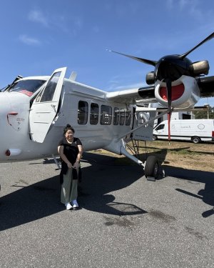
The NEON Ambassador Program empowers researchers and educators to expand awareness and use of NEON data, resources, and expertise across scientific and educational communities. Through training, mentorship and community-building activities, Ambassadors help more people engage with NEON data and advance open, continental-scale ecology.
Meet Dr. Di Yang: Yang is an Assistant Professor in the Department of Geography at the University of Florida, where she studies how remote sensing, geospatial analytics, machine learning, and citizen science can help scientists understand changing landscapes. A longtime NEON data user, Yang brings NEON field and airborne remote sensing data into her research, teaching, and community science outreach.
Her Ambassador Experience
Dr. Yang’s connection to NEON began more than 13 years ago, as a Ph.D. student, and has continued to shape her research and teaching ever since. She joined the Ambassador Program to give back to the NEON community and help more people see how open ecological data can support science, education, and environmental decision-making.
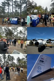
Dr. Di Yang brought her students to see the NEON Airborne Observation Platform payload and tour the airplane during recent flights in Florida. Photo courtesy of Di Yang.
As an Ambassador, Yang has focused on data literacy and citizen science: helping students, researchers, and members of the public connect field observations with larger environmental datasets. At the University of Florida, she uses NEON lidar and hyperspectral data in undergraduate and graduate remote sensing courses, where students complete labs connected to the nearby Ordway-Swisher Biological Station. She also brings students to tour the NEON field site and, when possible, connects them with NEON Airborne Observation Platform flight tours, giving them a firsthand look at how observational and airborne remote sensing data are collected.
Yang has also organized training activities that connect citizen science observations with remote sensing and environmental monitoring. In a virtual workshop for the Association for Forest Spatial Analysis Technologies (ForestSAT) 2026 with Dr. Peder Nelson of Oregon State University, she introduced participants to tools such as NASA GLOBE Observer for collecting tree height and land cover data and explored how community observations can be integrated with Earth observation data. For Yang, activities like this help show participants that their data can contribute to larger scientific products and environmental questions.
That focus on access also extends to NEON tutorials and training resources. Yang is interested in making NEON learning resources easier for different audiences to find and use, including students, researchers, public users, and land managers. Across her Ambassador work, she sees NEON as a bridge between professional researchers and broader communities interested in understanding environmental change.
“The Ambassador Program is a bridge, but not just between sites and scientists. It's between the career you're trying to build and the data you need to build it. For early-career researchers, NEON doesn't just support your research. It makes your research possible.”
— Dr. Di Yang
About Her Research: Mapping Forest Change and Wildfire Vulnerability
What’s the question?
How can NEON field and remote sensing data help researchers understand forest condition, land use history, and wildfire vulnerability across large landscapes?
The big picture:
Forests are shaped by climate, disturbance, and human land use, which influence forest structure, tree health, and wildfire patterns. By combining standardized NEON field measurements with remote sensing data, researchers can study forest conditions at individual sites and scale those insights across broader regions. This can help scientists and land managers better understand where forests may be more vulnerable to wildfire and where management action may be most needed.
How she did it:
In one current project, Yang and her student Olivia Zhang are using NEON field data to map tree mortality across five NEON forest sites. The team combines NEON Vegetation Structure observations (which identify individual trees as live, standing dead, damaged or diseased) with Google AlphaEarth Foundations satellite embeddings and the NEON canopy height model. By combining these inputs in Google Earth Engine, the team is testing how well machine learning models can map tree mortality at 10 m resolution across different forest types.
The project spans five NEON sites: Talladega National Forest, Yellowstone National Park, Rocky Mountain National Park, Wind River Experimental Forest and Great Smoky Mountains National Park. Early results suggest that the approach can achieve similar accuracy across very different forest types, suggesting that NEON field data can help train models that transfer across sites and biomes. To make the results easier to explore, Yang’s team also developed an interactive Google Earth Engine app that allows users to view the satellite embeddings, NEON field observations, and tree mortality classification results across the five NEON sites.
This current tree mortality mapping work builds on methods Yang has already applied in a published study of wildfire vulnerability in Yellowstone National Park. In that study, she and her collaborators used NEON Vegetation Structure along with NEON AOP-derived data to map standing dead trees and identify areas of higher wildfire vulnerability near park assets.
This work reflects Yang’s broader research interest in using remote sensing, machine learning, and large ecological datasets to understand how forests change over time. In her NASA Early Career project, she is examining how long-term land use transformation has shaped fire regimes across western U.S. forests. NEON forest sites and remote sensing data provide an important way to scale those questions across distributed landscapes.
NEON data products used:
Read more: