Research Highlight
NEON Remote Sensing Flights Over Crested Butte Gather Data for LBNL Watershed Study
August 16, 2018
A study led by Lawrence Berkley National Laboratory (LBNL) has used the NEON Assignable Assets Program to gather airborne remote sensing data near Crested Butte, Colorado. The Watershed Function Scientific Focus Area (SFA) project will use data from the NEON Airborne Observation Platform (AOP) to study plant community distributions and canopy biochemistry to shed light on watershed systems.
Studying Watershed Health and Function
The Watershed Function SFA is a Department of Energy (DOE) program studying the interactions among vegetation, soil, fluvial (stream and river), and subsurface components of watersheds. Watersheds have critical hydrological and biogeochemical functions that ultimately support all forms of life on Earth. Understanding these processes is essential for effective management of water and land resources.
The Watershed Function SFA looks at watersheds as "systems of systems" to study how water, nitrogen, carbon and other elements move into, out of and through the watershed. Looking at how hydrological and biogeochemical processes are changing over time will also help researchers understand, model and predict the impact of climate change and land use changes on watersheds and their downstream areas.
Vegetation health, distribution and biochemistry are an important part of the watershed study. Plants continually exchange water, nutrients and gases between soil systems and the atmosphere. Studying these exchanges provides insights into the overall health of the watershed and its vegetation, the carbon storage potential of vegetation in the watershed, the net exchange of water in the watershed system, and other key indicators. Looking at how plant distribution and traits are changing over time can also help researchers understand how the watershed is responding to changes in climate (including temperature and precipitation patterns), invasive species and land use.
The Watershed Function SFA is specifically focused on watersheds in mountainous regions. The study seeks to understand how permutations in variables in mountainous watersheds such as precipitation patterns, snowmelt dates and temperature impact the delivery of water and nutrients in downstream areas.
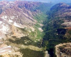
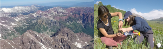
One of the watershed areas studied in the SFA is near Crested Butte, CO. The East River Watershed SFA site encompasses the drainages of the East River, Washington Gulch, Slate River and Coal Creek, which feed into water systems that irrigate 5.5 million acres of land and deliver water to one in ten people in the U.S. Researchers are developing models of the hydrological and biogeochemical processes that will help them understand how the watershed is changing on both a seasonal and decadal scale, and how these changes will impact all of the areas downstream that depend on it.
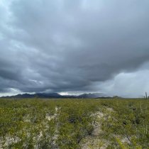
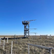
Aerial images of Crested Butte from a data collection campaign
Using Airborne Remote Sensing Data to Study Vegetation Indices
Gathering information on plant species distribution, traits, health and biochemistry has traditionally been done through on-the-ground observations collected by field ecologists. These methods are both time and labor intensive, which limits the area that can be effectively studied.
Airborne remote sensing can help researchers gather important data over much larger geographic scales than is possible through manual field observation. Light aircraft are equipped with a variety of sensors that collect data as the planes fly over the landscape being studied. The NEON AOPs have sensor payloads that include:
- a hyperspectral imaging spectrometer
- a full waveform and discrete return LiDAR
- a high-resolution Red, Blue Green (RGB) camera
Together, these instruments create a data-rich map of the landscape below, including visual, topographic and biochemical information. The NEON project gathers remote sensing data over each of the NEON field sites on a rotating schedule (see the 2018 schedule). NEON AOPs provide a number of data products related to key vegetation parameters, including:
- Vegetation cover and dominant vegetation type
- Vegetation structure including height and Leaf Area Index (LAI)
- Vegetation condition
- Vegetation biochemistry and heterogeneity
- Canopy chemistry (Nitrogen index)
- Topography, such as elevation, slope and aspect
- Vegetation greenness and health (NDVI, EVI)
Researchers at LBNL were interested in using NEON AOPs to gather broader scale vegetation. But first, they needed to see how remote sensing data correlates with field observations. Adding remote sensing data to the field data they are already collecting could help them scale up their foliar chemistry observations from the individual tree level to a regional level.
Collecting Vegetation Data from the East River Watershed
After several months of planning, remote sensing data collection surveys took place over the East River Watershed SFA site during the last two weeks of June 2018. The NEON airborne remote sensing team conducted eight flights during this time to cover the 82,500-acre site. Overall, they ran 72 flight lines, ranging in length from 2 km to 24 km, to build a complete map of the area. The dataset includes all of the standard AOP data products.
Areas observed with the AOP were coordinated with the LBNL field team so that field observation data and remote sensing data for each section of the site would be coincident. This was done so that data on the ground and from the air would both be taken under similar weather conditions for comparative purposes.
The mountainous terrain near Crested Butte added some challenges for the flight team. Rather than maintaining a steady altitude, as the AOPs do over most sites, the flight team adjusted their altitude to account for the topography of the land below, a practice known as "terrain following."
The data products collected over the East River Watershed SFA site are currently being processed and quality checked. Once this is complete, they will be turned over to the LBNL research team for their own analysis.
The First AOP Run for the NEON Assignable Asset Program
The East River Watershed SFA is not part of the regular AOP flight plan for the NEON project. Researchers for the Watershed Function SFA requested the data acquisition over the Crested Butte site through the NEON Assignable Assets Program. This program allows principal investigators to contract with Battelle to collect remote sensing data customized to the needs of their studies at the locations they choose. Researchers can also use the Assignable Assets program to request access and use of other parts of the NEON infrastructure including deployments of mobile sensor arrays, additions of sensors to NEON field sites and even using field staff for additional field sampling activities.
The LBNL project was the first use of the AOP under the Assignable Assets Program. The NEON project has three AOPs. Two of these are used to complete planned data acquisitions over NEON field sites. The third is available to other researchers on a cost reimbursable basis. Requests are evaluated based on feasibility, scientific justification and the potential impact on other NEON research activities. All assignable asset requests require the principal investigators to cover the costs of using NEON infrastructure.
Currently, there are already two additional AOP projects planned for outside researchers in 2018, and others under consideration. Battelle is currently accepting requests for AOP use for the 2018 and 2019 flight seasons.
For more information on requesting access to NEON infrastructure, visit the Assignable Assets Program to learn more.
To explore our open access airborne remote sensing data from NEON field sites, visit the NEON Data Portal.