NSF NEON, Operated by Battelle

Main navigation

  • About
    • NEON Overview
      • Vision and Management
      • Spatial and Temporal Design
      • History
    • About the NEON Biorepository
      • ASU Biorepository Staff
      • Contact the NEON Biorepository
    • Observatory Blog
    • Newsletters
    • Staff
    • FAQ
    • Contact Us

    About

  • Data
    • Data Portal
      • Data Availability Charts
      • API & GraphQL
      • Prototype Data
      • Externally Hosted Data
    • Data Collection Methods
      • Airborne Observation Platform (AOP)
      • Instrument System (IS)
        • Instrumented Collection Types
        • Aquatic Instrument System (AIS)
        • Terrestrial Instrument System (TIS)
      • Observational System (OS)
        • Observation Types
        • Observational Sampling Design
        • Sampling Schedules
        • Taxonomic Lists Used by Field Staff
        • Optimizing the Observational Sampling Designs
      • Protocols & Standardized Methods
    • Getting Started with NEON Data
      • neonUtilities for R and Python
      • Learning Hub
      • Code Hub
    • Using Data
      • Data Formats and Conventions
      • Released, Provisional, and Revised Data
      • Data Product Bundles
      • Usage Policies
      • Acknowledging and Citing NEON
      • Publishing Research Outputs
    • Data Notifications
    • NEON Data Management
      • Data Availability
      • Data Processing
      • Data Quality

    Data

  • Samples & Specimens
    • Biorepository Sample Portal at ASU
    • About Samples
      • Sample Types
      • Sample Repositories
      • Megapit and Distributed Initial Characterization Soil Archives
    • Finding and Accessing Sample Data
      • Species Checklists
      • Sample Explorer - Relationships and Data
      • Biorepository API
    • Requesting and Using Samples
      • Loans & Archival Requests
      • Usage Policies

    Samples & Specimens

  • Field Sites
    • Field Site Map and Info
    • Spatial Layers & Printable Maps

    Field Sites

  • Resources
    • Getting Started with NEON Data
    • Research Support Services
      • Field Site Coordination
      • Letters of Support
      • Mobile Deployment Platforms
      • Permits and Permissions
      • AOP Flight Campaigns
      • Research Support FAQs
      • Research Support Projects
    • Code Hub
      • neonUtilities for R and Python
      • Code Resources Guidelines
      • Code Resources Submission
      • NEON's GitHub Organization Homepage
    • Learning Hub
      • Tutorials
      • Workshops & Courses
      • Science Videos
      • Teaching Modules
    • Science Seminars and Data Skills Webinars
    • Document Library
    • Funding Opportunities

    Resources

  • Impact
    • Research Highlights
    • Papers & Publications
    • NEON in the News

    Impact

  • Get Involved
    • Upcoming Events
    • Research and Collaborations
      • Environmental Data Science Innovation and Inclusion Lab
      • Collaboration with DOE BER User Facilities and Programs
      • EFI-NEON Ecological Forecasting Challenge
      • NEON Great Lakes User Group
      • NCAR-NEON-Community Collaborations
    • Advisory Groups
      • Science, Technology & Education Advisory Committee
      • Technical Working Groups
    • NEON Ambassador Program
      • Exploring NEON-Derived Data Products Workshop Series
    • Partnerships
    • Community Engagement
    • Work Opportunities

    Get Involved

  • My Account
  • Search

Search

About

  • NEON Overview
  • About the NEON Biorepository
  • Observatory Blog
  • Newsletters
  • Staff
  • FAQ
  • Contact Us

Breadcrumb

  1. About
  2. Observatory Blog
  3. Full Airborne Observation Platform Embarks on Inaugural Journey

Full Airborne Observation Platform Embarks on Inaugural Journey

May 2, 2012

View of a twin otter from the nose in the hanger

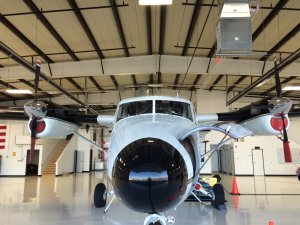
NEON's Airborne Observation Platform (AOP) will depart on its inaugural test flights out of the Grand Junction Regional Airport starting this Sunday and continuing into next week. AOP will conduct its first test flights with a full suite of airborne remote sensing instruments aboard a Twin Otter aircraft. Twin Otter International, a Department of Energy- and NASA-approved operator, provides aerial survey, surveillance and airborne research aircraft as well as engineering and technical support to the science community (and supports science globally). Part of the instrumentation that will be used was developed in collaboration with NASA’s Jet Propulsion Laboratory. The flights will occur between May 5 through May 11, 2012. NEON, with funding from the National Science Foundation, is building a network of field sites across the U.S. utilizing cutting-edge technology that will gather and synthesize continental-scale data over 30 years on the impacts of climate change, land use change and invasive species on natural resources and biodiversity.

One of NEON’s goals is to provide detailed aerial data about regional landscapes and vegetation, which will be collected using remote sensing by the AOP. The AOP platforms will consist of remote sensing instrumentation deployed on three Twin Otter aircraft that fly scientist-defined and routine patterns over all NEON sites. The NEON instrumentation mounted in the Twin Otter planes includes an imaging spectrometer operating in the visible to shortwave infrared region of the spectrum, a waveform light detection and ranging (LiDAR) instrument, and a high-resolution digital camera. The powerful combination of biochemical and structural information provided by spectroscopy and waveform LiDAR can be used to observe and quantify pest and pathogen outbreaks, responses to disturbances like wildfire, and observe many features of land use.

The camera and LiDAR are off-the-shelf instruments but the spectrometer is a state-of-the-science instrument co-developed with NASA’s Jet Propulsion Lab and the Carnegie Institution and is itself a major scientific advance. The Grand Junction flights will be used to prepare the instrumentation and crew for official flights over NEON sites in the near future. Airborne remote sensing bridges the gap between ground-based observations and satellite-based remote sensing. The measurements provided by the AOP will allow NEON to link processes on the ground with their consequences at continental scales. An example of a continental-scale ecology issue that can be analyzed using the AOP platform is is the spread and impact of the Mountain Pine Beetle in western North America.

Share

Related Posts:

Discontinuation of Select NEON Data Products

January 29, 2026

Resolved: NEON AOP Lidar Data Quality Issues Due to Mis-Classified Atmospheric Noise

January 23, 2026

AOP Data Availability Notification – Release 2026

December 15, 2025

NSF NEON, Operated by Battelle

Follow Us:

Join Our Newsletter

Get updates on events, opportunities, and how NEON is being used today.

Subscribe Now

Footer

  • About Us
  • Contact Us
  • Terms & Conditions
  • Careers
  • Code of Conduct

Copyright © Battelle, 2026

The National Ecological Observatory Network is a major facility fully funded by the U.S. National Science Foundation.

Any opinions, findings and conclusions or recommendations expressed in this material do not necessarily reflect the views of the U.S. National Science Foundation.