NSF NEON, Operated by Battelle

Main navigation

  • About
    • NEON Overview
      • Vision and Management
      • Spatial and Temporal Design
      • History
    • About the NEON Biorepository
      • ASU Biorepository Staff
      • Contact the NEON Biorepository
    • Observatory Blog
    • Newsletters
    • Staff
    • FAQ
    • Contact Us

    About

  • Data
    • Data Portal
      • Data Availability Charts
      • API & GraphQL
      • Prototype Data
      • Externally Hosted Data
    • Data Collection Methods
      • Airborne Observation Platform (AOP)
      • Instrument System (IS)
        • Instrumented Collection Types
        • Aquatic Instrument System (AIS)
        • Terrestrial Instrument System (TIS)
      • Observational System (OS)
        • Observation Types
        • Observational Sampling Design
        • Sampling Schedules
        • Taxonomic Lists Used by Field Staff
        • Optimizing the Observational Sampling Designs
      • Protocols & Standardized Methods
    • Getting Started with NEON Data
      • neonUtilities for R and Python
      • Learning Hub
      • Code Hub
    • Using Data
      • Data Formats and Conventions
      • Released, Provisional, and Revised Data
      • Data Product Bundles
      • Usage Policies
      • Acknowledging and Citing NEON
      • Publishing Research Outputs
    • Data Notifications
    • NEON Data Management
      • Data Availability
      • Data Processing
      • Data Quality

    Data

  • Samples & Specimens
    • Biorepository Sample Portal at ASU
    • About Samples
      • Sample Types
      • Sample Repositories
      • Megapit and Distributed Initial Characterization Soil Archives
    • Finding and Accessing Sample Data
      • Species Checklists
      • Sample Explorer - Relationships and Data
      • Biorepository API
    • Requesting and Using Samples
      • Loans & Archival Requests
      • Usage Policies

    Samples & Specimens

  • Field Sites
    • Field Site Map and Info
    • Spatial Layers & Printable Maps

    Field Sites

  • Resources
    • Getting Started with NEON Data
    • Research Support Services
      • Field Site Coordination
      • Letters of Support
      • Mobile Deployment Platforms
      • Permits and Permissions
      • AOP Flight Campaigns
      • Research Support FAQs
      • Research Support Projects
    • Code Hub
      • neonUtilities for R and Python
      • Code Resources Guidelines
      • Code Resources Submission
      • NEON's GitHub Organization Homepage
    • Learning Hub
      • Tutorials
      • Workshops & Courses
      • Science Videos
      • Teaching Modules
    • Science Seminars and Data Skills Webinars
    • Document Library
    • Funding Opportunities

    Resources

  • Impact
    • Research Highlights
    • Papers & Publications
    • NEON in the News

    Impact

  • Get Involved
    • Upcoming Events
    • Research and Collaborations
      • Environmental Data Science Innovation and Inclusion Lab
      • Collaboration with DOE BER User Facilities and Programs
      • EFI-NEON Ecological Forecasting Challenge
      • NEON Great Lakes User Group
      • NCAR-NEON-Community Collaborations
    • Advisory Groups
      • Science, Technology & Education Advisory Committee
      • Technical Working Groups
    • NEON Ambassador Program
      • Exploring NEON-Derived Data Products Workshop Series
    • Partnerships
    • Community Engagement
    • Work Opportunities

    Get Involved

  • My Account
  • Search

Search

About

  • NEON Overview
  • About the NEON Biorepository
  • Observatory Blog
  • Newsletters
  • Staff
  • FAQ
  • Contact Us

Breadcrumb

  1. About
  2. Observatory Blog
  3. Bird point IDs within grids were transposed resulting in inaccurate point-level spatial data

Data Notification

Bird point IDs within grids were transposed resulting in inaccurate point-level spatial data

November 13, 2023

Grid point information in the Breeding landbird point counts data product (DP1.10003.001) have been incorrectly reported for two-thirds of grid points due to a transposition error when converting numeric point labels (1-9) into alphanumeric point IDs (A1-C3) during data ingest (see Figure 1 below that illustrates the transposition). This conversion was implemented to maintain the NEON alphanumeric data format while accommodating the request from the field observers to use the numeric system, but the conversion was unfortunately implemented incorrectly in the data ingest system. This applies to all years (2013-2022) at all 32 NEON sites where point counts are collected in 9-point grids (BARR, BART, BONA, CLBJ, CPER, DEJU, DSNY, GRSM, GUAN, HARV, HEAL, JERC, JORN, KONZ, MLBS, MOAB, NIWO, OAES, ONAQ, ORNL, OSBS, RMNP, SJER, SRER, STEI, TALL, TEAK, UKFS, UNDE, WOOD, WREF, YELL). Point counts at the remaining 15 sites are dispersed among distributed base plots and are not impacted.

Spatial data published in the brd_perpoint table are for the centroid of the grid only and are not impacted. These non-impacted data include latitude and longitude, National Land Cover Database (NLCD) vegetation class, and elevation. Spatial data associated with the individual points within the 9-point grids are accessed via the NEON API, the terrestrial sampling locations shapefile, or the geoNEON R package. The point-level spatial data are accurate on their own, but the mislabeling of the point IDs in the count data will have resulted in inaccuracies if the spatial and count data were joined. Users who have accessed grid point spatial data from these sources and joined it to the published count data should update their analyses using the corrected data product.

All transposed grid point ID values have been corrected as of 11/13/2023. As an additional measure to eliminate the possibility for incorrect transposition in the future, we have converted all alphanumeric point IDs to numeric point IDs that align with the grid labeling convention used in the field (Figure 2). The change will be reflected in Provisional data (2022 – 2023 data) starting in mid-November 2023; it will appear in the 2013 – 2021 data upon publication of the 2024 Release in January 2024. RELEASE-2021, -2022, and -2023 data contain the inaccurate alphanumeric point ID labels and will not change as releases are intended to be static.

Wherever possible, we encourage data users to use RELEASE-2024 and later to avoid this problem. If data from RELEASE-2021, -2022, or -2023 are used and point-level spatial resolution is needed, the following R code snippet can be used to convert the grid point ID values to the numeric convention now in use and correct for the transposition.


point_conversion <- data.frame(point=c("A1","A2","A3",
                "B1","B2","B3","C1","C2","C3"),
                point_corrected=c(1,4,7,2,5,8,3,6,9))

brd_perpoint$pointID <-
                stringi::stri_replace_all_fixed(str=brd_perpoint$pointID,
                pattern=point_conversion$point,
                replacement=point_conversion$point_corrected,
                vectorize_all=F)

brd_perpoint$eventID <-
                stringi::stri_replace_all_regex(str=brd_perpoint$eventID,
                
pattern=point_conversion$point,
                
replacement=point_conversion$point_corrected,
               
 vectorize_all=F)

brd_countdata$pointID <-
                
stringi::stri_replace_all_fixed(str=brd_countdata$pointID,
                pattern=point_conversion$point,
                replacement=point_conversion$point_corrected,
                vectorize_all=F)

brd_countdata$eventID <-
                
stringi::stri_replace_all_regex(str=brd_countdata$eventID,
                pattern=point_conversion$point,
                replacement=point_conversion$point_corrected,
                vectorize_all=F)


Please use the Contact Us form for further inquiries related to this issue; select DP1.10003.001 in the Data Product dropdown list and include the term "INC0069692".
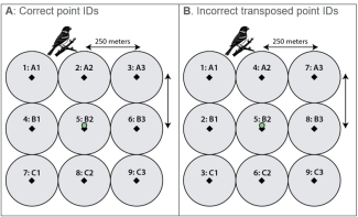
 

figure 1

Figure 1

Figure 1. (A) Bird point grid that was used for field data collection including numeric and alphanumeric point IDs, where, for example, point count data collected at numeric value 3 correspond to alphanumeric value A3 (upper right grid corner). Gray circles indicate the search area, and the green circle indicates the centroid of a collocated Distributed base plot, where other NEON data are collected. (B) Inaccurate bird point grid used upon data ingest prior to 2023 including numeric and alphanumeric point IDs, where, for example, point count data collected at numeric value 3 are inaccurately associated with spatial information for alphanumeric value C1 (lower left grid corner). Point IDs were transposed for all points except for A1, B2, and C3.
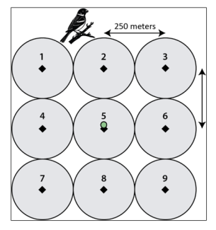
figure 2

Figure 2

Figure 2. Updated bird grid point labels containing only numeric values. This labeling system will be applied in Provisional data starting in mid-November 2023 and in Release data in the upcoming 2024 data release.

Share

Related Posts:

Pilot Results and Updated Methodology - mosquito pathogen status (DP1.10041.001)

October 30, 2025

Modification of Select NEON Data Products

January 29, 2026

Discontinuation of Select NEON Data Products

January 29, 2026

NSF NEON, Operated by Battelle

Follow Us:

Join Our Newsletter

Get updates on events, opportunities, and how NEON is being used today.

Subscribe Now

Footer

  • About Us
  • Contact Us
  • Terms & Conditions
  • Careers
  • Code of Conduct

Copyright © Battelle, 2026

The National Ecological Observatory Network is a major facility fully funded by the U.S. National Science Foundation.

Any opinions, findings and conclusions or recommendations expressed in this material do not necessarily reflect the views of the U.S. National Science Foundation.