NSF NEON, Operated by Battelle

Main navigation

  • About
    • NEON Overview
      • Vision and Management
      • Spatial and Temporal Design
      • History
    • About the NEON Biorepository
      • ASU Biorepository Staff
      • Contact the NEON Biorepository
    • Observatory Blog
    • Newsletters
    • Staff
    • FAQ
    • Contact Us

    About

  • Data
    • Data Portal
      • Data Availability Charts
      • API & GraphQL
      • Prototype Data
      • Externally Hosted Data
    • Data Collection Methods
      • Airborne Observation Platform (AOP)
      • Instrument System (IS)
        • Instrumented Collection Types
        • Aquatic Instrument System (AIS)
        • Terrestrial Instrument System (TIS)
      • Observational System (OS)
        • Observation Types
        • Observational Sampling Design
        • Sampling Schedules
        • Taxonomic Lists Used by Field Staff
        • Optimizing the Observational Sampling Designs
      • Protocols & Standardized Methods
    • Getting Started with NEON Data
      • neonUtilities for R and Python
      • Learning Hub
      • Code Hub
    • Using Data
      • Data Formats and Conventions
      • Released, Provisional, and Revised Data
      • Data Product Bundles
      • Usage Policies
      • Acknowledging and Citing NEON
      • Publishing Research Outputs
    • Data Notifications
    • NEON Data Management
      • Data Availability
      • Data Processing
      • Data Quality

    Data

  • Samples & Specimens
    • Biorepository Sample Portal at ASU
    • About Samples
      • Sample Types
      • Sample Repositories
      • Megapit and Distributed Initial Characterization Soil Archives
    • Finding and Accessing Sample Data
      • Species Checklists
      • Sample Explorer - Relationships and Data
      • Biorepository API
    • Requesting and Using Samples
      • Loans & Archival Requests
      • Usage Policies

    Samples & Specimens

  • Field Sites
    • Field Site Map and Info
    • Spatial Layers & Printable Maps

    Field Sites

  • Resources
    • Getting Started with NEON Data
    • Research Support Services
      • Field Site Coordination
      • Letters of Support
      • Mobile Deployment Platforms
      • Permits and Permissions
      • AOP Flight Campaigns
      • Research Support FAQs
      • Research Support Projects
    • Code Hub
      • neonUtilities for R and Python
      • Code Resources Guidelines
      • Code Resources Submission
      • NEON's GitHub Organization Homepage
    • Learning Hub
      • Tutorials
      • Workshops & Courses
      • Science Videos
      • Teaching Modules
    • Science Seminars and Data Skills Webinars
    • Document Library
    • Funding Opportunities

    Resources

  • Impact
    • Research Highlights
    • Papers & Publications
    • NEON in the News

    Impact

  • Get Involved
    • Upcoming Events
    • Research and Collaborations
      • Environmental Data Science Innovation and Inclusion Lab
      • Collaboration with DOE BER User Facilities and Programs
      • EFI-NEON Ecological Forecasting Challenge
      • NEON Great Lakes User Group
      • NCAR-NEON-Community Collaborations
    • Advisory Groups
      • Science, Technology & Education Advisory Committee
      • Technical Working Groups
    • NEON Ambassador Program
      • Exploring NEON-Derived Data Products Workshop Series
    • Partnerships
    • Community Engagement
    • Work Opportunities

    Get Involved

  • My Account
  • Search

Search

About

  • NEON Overview
  • About the NEON Biorepository
  • Observatory Blog
  • Newsletters
  • Staff
  • FAQ
  • Contact Us

Breadcrumb

  1. About
  2. Observatory Blog
  3. Updates to AOP’s Spectrometer Orthorectified at-Sensor Radiance data product

Data Notification

Updates to AOP’s Spectrometer Orthorectified at-Sensor Radiance data product

February 4, 2021

AOP has updated the file name, format and metadata for the Spectrometer Orthorectified at-sensor radiance data product (DP1.30008.001).

1. The radiance HDF5 filename has been modified by replacing the 6 digit (HHMMSS) unique identifier based on acquisition time, with a flight plan line number. The 6-digit code can still be retrieved from the HDF5 file attributes if needed.

Example:

  Previous File Name: NEON_D10_R10A_DP1_20200607_151846_radiance.h5

  Current File Name: NEON_D10_R10A_DP1_20200607_L001-1_radiance.h5

This change was implemented to facilitate matching the radiance flight lines with the lidar flight lines, which are also named according to the line number. Note that reflectance files (NEON.DOM.SITE.DP1.30006.001) maintain the 6-digit code, but are also planned for a file name update by January 2022.

2. A bad detector element (BDE) mask has been included under ‘Ancillary_Rasters’. This mask will allow users to identify pixels which have been determined in internal QA checks to be of low quality. These low quality pixels have undergone a statistical correction based on surrounding pixel values to predict their value. The addition of the BDE mask raster only applies to data collected for year 2020 onwards, however, this correction has been consistently applied to data from all years.

3. The at-sensor radiance raster has been updated. In previous versions of the product, the at-sensor radiance data values were each represented as a single precision float. In the updated product, the radiance data has been split into separate ‘integer’ and ‘decimal’ rasters. The integer raster contains the original whole number of the radiance, now stored as an unsigned 8-bit integer. The decimal portion is the fractional radiance component scaled by 50000, and stored as an unsigned 16 bit integer. This saves one byte of storage per pixel. Compression of the data is also slightly improved resulting in an overall storage reduction of approximately 50% per data file, with a negligible loss of precision at the 5th decimal place. As such, code which has been designed to read the radiance data prior to this modification will no longer function. Code will require an update to read the decimal and integer rasters separately, and then combine by adding them together after dividing the decimal raster by 50000.

Updates in the Spectrometer Ortho-rectified at-sensor radiance data product

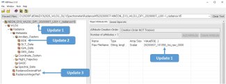
Fig 1: Updates in the Spectrometer Ortho-rectified at-sensor radiance data product (DP1.30008.001)


Share

Related Posts:

Discontinuation of Select NEON Data Products

January 29, 2026

Resolved: NEON AOP Lidar Data Quality Issues Due to Mis-Classified Atmospheric Noise

January 23, 2026

AOP Data Availability Notification – Release 2026

December 15, 2025

NSF NEON, Operated by Battelle

Follow Us:

Join Our Newsletter

Get updates on events, opportunities, and how NEON is being used today.

Subscribe Now

Footer

  • About Us
  • Contact Us
  • Terms & Conditions
  • Careers
  • Code of Conduct

Copyright © Battelle, 2026

The National Ecological Observatory Network is a major facility fully funded by the U.S. National Science Foundation.

Any opinions, findings and conclusions or recommendations expressed in this material do not necessarily reflect the views of the U.S. National Science Foundation.