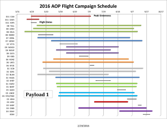
NEON's 2016 remote sensing flight schedule now available
February 19, 2016

The 2016 flight campaign for the Airborne Observation Platform (AOP) will run from April to October this year and cover nine of 20 NEON domains. Survey flights are scheduled for 25 terrestrial field sites and 17 aquatic field sites. Read on to learn more about what instruments will be used, how to plan your research activities in correlation with NEON’s flight schedule and how to access AOP data.
How NEON conducts airborne surveys
A minimum of 100 km2 will be surveyed at all terrestrial sites, optimized to capture the spatial heterogeneity of ecological features in the landscape. Where possible, AOP flights also cover the watershed of each terrestrial and aquatic site.
At terrestrial sites, the surveyed area includes the NEON tower airshed and distributed long-term sampling plots. These sites are scheduled to be flown during peak greenness, defined as the range of dates where MODIS NDVI is within 90% of the site maximum. Surveys conducted during peak greenness will minimize signal uncertainty caused by seasonal variations in plant phenology and ensure spatial and temporal consistency in data products across multiple years. To minimize atmospheric and solar effects, data acquisition will be attempted at less than 10% cloud cover and within solar elevation angles of 40° above the horizon.
What instruments are used for NEON’s AOP?
Each AOP payload consists of an imaging spectrometer, a waveform light detection and ranging (LIDAR) instrument and a high-resolution digital camera. These instruments are mounted in a DeHavilland DHC-6 Twin Otter aircraft that flies at a nominal altitude of 1000 m above ground level (AGL) at a speed of 100 knots. The flight parameters enable meter-scale spectroscopy, decimeter-scale photography, and ~4 points-per-meter discreet and waveform lidar measurements at a sufficient signal-to-noise ratio to retrieve vegetation vertical structure and biogeochemical properties from measured reflectance spectra.
Data collected by the AOP
Data production from the AOP 2016 survey flights is estimated to be 26 Tb of raw L0 data which will yield approximately 100 Tb in L1-L3 data products.
Level 0 data are defined as the raw data records collected directly by the AOP instruments. L0 data are then processed into physical units and placed into a coordinate reference system to produce Level 1 data products. Examples of L1 data include orthorectified directional surface reflectance spectrometer data or LiDAR LAS 1.3 point clouds, both delivered by flight line. Level 2 data are derived data products, such as vegetation indices derived from surface reflectance, and are also distributed by flight line. Level 3 data are mosaicked and separated into 1 km by 1 km tiles and may contain data such as directional reflectance or derived data products such as vegetation indices, high resolution camera mosaics, terrain slope and terrain aspect, and others.
As 2016 airborne data become available, you may request these data online. We also have data from previous survey flights already available.
Planning your research in coordination with AOP flights
If you would like to plan research activities on the ground to coincide with AOP surveys of certain areas, please email us to join our mailing list. The NEON AOP flight operations team will email daily reports on the status of flights over each site which will be more accurate than the schedule posted in this article. Although the NEON AOP flight operations team will attempt adherence to the the published schedule, weather and logistical constraints may result in modifications to this plan.
At this time we are unable to accommodate requests for flights over additional areas due to the constraints in our flight campaign schedule. We do anticipate outfitting a payload in 2018 that that will be dedicated to Principal Investigator (PI)-led science flights under a separate process led by NSF.