NSF NEON, Operated by Battelle

Main navigation

  • About
    • NEON Overview
      • Vision and Management
      • Spatial and Temporal Design
      • History
    • About the NEON Biorepository
      • ASU Biorepository Staff
      • Contact the NEON Biorepository
    • Observatory Blog
    • Newsletters
    • Staff
    • FAQ
    • Contact Us

    About

  • Data
    • Data Portal
      • Data Availability Charts
      • API & GraphQL
      • Prototype Data
      • Externally Hosted Data
    • Data Collection Methods
      • Airborne Observation Platform (AOP)
      • Instrument System (IS)
        • Instrumented Collection Types
        • Aquatic Instrument System (AIS)
        • Terrestrial Instrument System (TIS)
      • Observational System (OS)
        • Observation Types
        • Observational Sampling Design
        • Sampling Schedules
        • Taxonomic Lists Used by Field Staff
        • Optimizing the Observational Sampling Designs
      • Protocols & Standardized Methods
    • Getting Started with NEON Data
      • neonUtilities for R and Python
      • Learning Hub
      • Code Hub
    • Using Data
      • Data Formats and Conventions
      • Released, Provisional, and Revised Data
      • Data Product Bundles
      • Usage Policies
      • Acknowledging and Citing NEON
      • Publishing Research Outputs
    • Data Notifications
    • NEON Data Management
      • Data Availability
      • Data Processing
      • Data Quality

    Data

  • Samples & Specimens
    • Biorepository Sample Portal at ASU
    • About Samples
      • Sample Types
      • Sample Repositories
      • Megapit and Distributed Initial Characterization Soil Archives
    • Finding and Accessing Sample Data
      • Species Checklists
      • Sample Explorer - Relationships and Data
      • Biorepository API
    • Requesting and Using Samples
      • Loans & Archival Requests
      • Usage Policies

    Samples & Specimens

  • Field Sites
    • Field Site Map and Info
    • Spatial Layers & Printable Maps

    Field Sites

  • Resources
    • Getting Started with NEON Data
    • Research Support Services
      • Field Site Coordination
      • Letters of Support
      • Mobile Deployment Platforms
      • Permits and Permissions
      • AOP Flight Campaigns
      • Research Support FAQs
      • Research Support Projects
    • Code Hub
      • neonUtilities for R and Python
      • Code Resources Guidelines
      • Code Resources Submission
      • NEON's GitHub Organization Homepage
    • Learning Hub
      • Tutorials
      • Workshops & Courses
      • Science Videos
      • Teaching Modules
    • Science Seminars and Data Skills Webinars
    • Document Library
    • Funding Opportunities

    Resources

  • Impact
    • Research Highlights
    • Papers & Publications
    • NEON in the News

    Impact

  • Get Involved
    • Upcoming Events
    • Research and Collaborations
      • Environmental Data Science Innovation and Inclusion Lab
      • Collaboration with DOE BER User Facilities and Programs
      • EFI-NEON Ecological Forecasting Challenge
      • NEON Great Lakes User Group
      • NCAR-NEON-Community Collaborations
    • Advisory Groups
      • Science, Technology & Education Advisory Committee
      • Technical Working Groups
    • NEON Ambassador Program
      • Exploring NEON-Derived Data Products Workshop Series
    • Partnerships
    • Community Engagement
    • Work Opportunities

    Get Involved

  • My Account
  • Search

Search

About

  • NEON Overview
  • About the NEON Biorepository
  • Observatory Blog
  • Newsletters
  • Staff
  • FAQ
  • Contact Us

Breadcrumb

  1. About
  2. Observatory Blog
  3. AOP covers ground with 166 flight hours in 2015

AOP covers ground with 166 flight hours in 2015

October 13, 2015

The NEON Airborne Observation Platform (AOP) team recently wrapped up their fourth flight season.

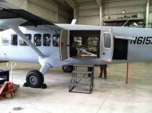
The AOP collects remote sensing data over NEON field sites annually using sensors mounted on a Twin Otter aircraft: sensors consist of a hyperspectral imaging spectrometer, a full waveform and discrete return LiDAR, and a high-resolution Red, Blue Green (RGB) camera. Learn more about NEON airborne remote sensing collection methods and instruments here.

How much ground did the NEON AOP cover this summer?

Over four months this summer, while targeting peak greenness, the AOP team:

  • Conducted five flight campaigns
  • Collected AOP data for two domains (D07, D08), totalling 6 NEON field sites
  • Conducted calibration and test flights in D10 to evaluate the performance existing sensors and three new sensors: Riegl LiDAR, Riegl camera and Solar Spectral Irradiance Monitor (SSIM)
  • Conducted 76 flights totaling 166 hours

2015 airborne data are available now

Data from the AOP build a robust time series of landscape-scale changes in numerous physical, biological and biochemical metrics, such as vegetation cover and density, canopy chemistry, and topography, including elevation, slope and aspect. Explore and request airborne data.

A team effort in the air and on the ground

For the flight team members, flight days may last up to 12 hours. Each flight is carefully orchestrated and requires two pilots, two airborne sensor operators and one ground crew coordinator. Staff Scientist John Musinsky works closely with the AOP team to design flight plans to ensure the payloads collect remote sensing data over specific areas in order to provide ecologically relevant data that enable scaling of in situ observations to regional and continental-scale models.

Where possible, a NEON AOP field team also collects ground data to facilitate validation and calibration of the airborne instrumentation. Air and ground crews must form a cohesive team and be in constant contact to ensure that the timing and location of field samples are insync with overflights. Data collected from the field are also made available for download when requesting airborne data.

What’s up in the air (literally) for AOP in 2016?

In 2016, the AOP is scheduled to collect airborne remote sensing data over a five-month period. Eventually, the AOP will consist of two payloads divided between the eastern and western United States and a third payload to facilitate Principal Investigator research.

Share

Related Posts:

AOP Data Availability Notification – Release 2026

December 15, 2025

Discontinuation of Select NEON Data Products

January 29, 2026

Resolved: NEON AOP Lidar Data Quality Issues Due to Mis-Classified Atmospheric Noise

January 23, 2026

NSF NEON, Operated by Battelle

Follow Us:

Join Our Newsletter

Get updates on events, opportunities, and how NEON is being used today.

Subscribe Now

Footer

  • About Us
  • Contact Us
  • Terms & Conditions
  • Careers
  • Code of Conduct

Copyright © Battelle, 2026

The National Ecological Observatory Network is a major facility fully funded by the U.S. National Science Foundation.

Any opinions, findings and conclusions or recommendations expressed in this material do not necessarily reflect the views of the U.S. National Science Foundation.