NSF NEON, Operated by Battelle

Main navigation

  • About Us
    • Overview
      • Spatial and Temporal Design
      • History
    • Vision and Management
    • Advisory Groups
      • Science, Technology & Education Advisory Committee
      • Technical Working Groups (TWGs)
    • FAQ
    • Contact Us
      • Contact NEON Biorepository
      • Field Offices
    • User Accounts
    • Staff
    • Code of Conduct

    About Us

  • Data & Samples
    • Data Portal
      • Explore Data Products
      • Data Availability Charts
      • Spatial Data & Maps
      • Document Library
      • API & GraphQL
      • Prototype Data
      • External Lab Data Ingest (restricted)
    • Data Themes
      • Biogeochemistry
      • Ecohydrology
      • Land Cover and Processes
      • Organisms, Populations, and Communities
    • Samples & Specimens
      • Discover and Use NEON Samples
        • Sample Types
        • Sample Repositories
        • Sample Explorer
        • Megapit and Distributed Initial Characterization Soil Archives
      • Sample Processing
      • Sample Quality
      • Taxonomic Lists
    • Collection Methods
      • Protocols & Standardized Methods
      • Airborne Remote Sensing
        • Flight Box Design
        • Flight Schedules and Coverage
        • Daily Flight Reports
          • AOP Flight Report Sign Up
        • Camera
        • Imaging Spectrometer
        • Lidar
      • Automated Instruments
        • Site Level Sampling Design
        • Sensor Collection Frequency
        • Instrumented Collection Types
          • Meteorology
          • Phenocams
          • Soil Sensors
          • Ground Water
          • Surface Water
      • Observational Sampling
        • Site Level Sampling Design
        • Sampling Schedules
        • Observation Types
          • Aquatic Organisms
            • Aquatic Microbes
            • Fish
            • Macroinvertebrates & Zooplankton
            • Periphyton, Phytoplankton, and Aquatic Plants
          • Terrestrial Organisms
            • Birds
            • Ground Beetles
            • Mosquitoes
            • Small Mammals
            • Soil Microbes
            • Terrestrial Plants
            • Ticks
          • Hydrology & Geomorphology
            • Discharge
            • Geomorphology
          • Biogeochemistry
          • DNA Sequences
          • Pathogens
          • Sediments
          • Soils
            • Soil Descriptions
        • Optimizing the Observational Sampling Designs
    • Data Notifications
    • Data Guidelines and Policies
      • Acknowledging and Citing NEON
      • Publishing Research Outputs
      • Usage Policies
    • Data Management
      • Data Availability
      • Data Formats and Conventions
      • Data Processing
      • Data Quality
      • Data Product Bundles
      • Data Product Revisions and Releases
        • Release 2021
        • Release 2022
        • Release 2023
        • Release 2024
        • Release-2025
      • NEON and Google
      • Externally Hosted Data

    Data & Samples

  • Field Sites
    • About Field Sites and Domains
    • Explore Field Sites
    • Site Management Data Product

    Field Sites

  • Impact
    • Observatory Blog
    • Case Studies
    • Papers & Publications
    • Newsroom
      • NEON in the News
      • Newsletter Archive
      • Newsletter Sign Up

    Impact

  • Resources
    • Getting Started with NEON Data & Resources
    • Documents and Communication Resources
      • Papers & Publications
      • Document Library
      • Outreach Materials
    • Code Hub
      • Code Resources Guidelines
      • Code Resources Submission
      • NEON's GitHub Organization Homepage
    • Learning Hub
      • Science Videos
      • Tutorials
      • Workshops & Courses
      • Teaching Modules
    • Research Support Services
      • Field Site Coordination
      • Letters of Support
      • Mobile Deployment Platforms
      • Permits and Permissions
      • AOP Flight Campaigns
      • Research Support FAQs
      • Research Support Projects
    • Funding Opportunities

    Resources

  • Get Involved
    • Advisory Groups
      • Science, Technology & Education Advisory Committee
      • Technical Working Groups
    • Upcoming Events
    • NEON Ambassador Program
      • Exploring NEON-Derived Data Products Workshop Series
    • Research and Collaborations
      • Environmental Data Science Innovation and Inclusion Lab
      • Collaboration with DOE BER User Facilities and Programs
      • EFI-NEON Ecological Forecasting Challenge
      • NEON Great Lakes User Group
      • NEON Science Summit
      • NCAR-NEON-Community Collaborations
        • NCAR-NEON Community Steering Committee
    • Community Engagement
      • How Community Feedback Impacts NEON Operations
    • Science Seminars and Data Skills Webinars
      • Past Years
    • Work Opportunities
      • Careers
      • Seasonal Fieldwork
      • Internships
        • Intern Alumni
    • Partners

    Get Involved

  • My Account
  • Search

Search

Impact

  • Observatory Blog
  • Case Studies
  • Papers & Publications
  • Newsroom

Breadcrumb

  1. Impact
  2. Observatory Blog
  3. 50% of NEON’s remote sensing data products now available

50% of NEON’s remote sensing data products now available

July 1, 2016

AOP remote sensing banner

Two new products have recently been added to NEON’s available suite of airborne remote sensing data: fPAR (fractional Photosynthetically Active Radiation) and LAI (Leaf Area Index) bringing the total count of remote sensing data products to sixteen. NEON remote sensing data products can be grouped into three sensor categories: Lidar, spectrometer (both airborne and handheld) and camera. Currently, all lidar, camera and field spectrometer data products are available. With the completion of fPAR and LAI only the total biomass and surface albedo spectrometer products remain. Next up, NEON will create mosaics of all spectrometer products and camera data for each site. In total, NEON will provide 29 remote sensing data products once these last products are complete.

The fPAR product is defined as the fraction of incident photosynthetically active radiation (400-­‐700 nm) absorbed by the green elements of a vegetation canopy. The LAI product is defined as the ratio of upper leaf surface area to ground area (for broadleaf canopies), or projected conifer needle surface area to ground area (for coniferous plants) for a given unit area.

Both LAI and fPAR are available by flightline. They are delivered in GeoTIFF format, at a spatial resolution of 1 m. The uncertainty in fPAR, calculated assuming a 5% uncertainty in the spectrometer surface reflectance results, is also currently provided by flight line in GeoTiff format at 1 m spatial resolution. 


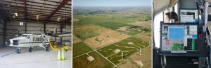
Please note that remote sensing data are available upon request and have been collected from a subset of NEON’s field sites at this time. To explore which sites currently have remote sensing data, click here.

Using NEON’s remote sensing data

NEON lidar and spectrometer data were recently featured in a week-long data institute in which graduate students and early career scientists learned how to use a variety of NEON data, as well as the importance of reproducible science methods. The course took place at NEON’s Boulder headquarters and culminated in group projects and presentations of unique applications of NEON data. Participant Enrique Montano said, “Access to hyperspectral data with coincident LiDAR is rare at best.  Having a workshop dedicated to using these data together is invaluable.”

Tristan Goulden, a remote sensing scientist with the NEON AOP (Airborne Observation Platform) group, who gave an introduction to imaging spectroscopy and introduction to discrete LiDAR also said, “it was a great opportunity to interact with a group of up-and-coming remote sensing and ecological scientists to showcase the capabilities of the NEON AOP data and understand the needs of our user community.”

Learn more about how to request NEON’s available remote sensing data.

Learn more about the NEON Airborne Observation Platform

Share

Related Posts:

AOP Data Availability Notification – Release 2025

January 10, 2025

Resolved: Spurious trace precipitation in Primary Precipitation data product

December 27, 2024

Precipitation (DP1.00006.001) to be split into three Data Products

December 27, 2024

NSF NEON, Operated by Battelle

Follow Us:

Join Our Newsletter

Get updates on events, opportunities, and how NEON is being used today.

Subscribe Now

Footer

  • About Us
  • Newsroom
  • Contact Us
  • Terms & Conditions
  • Careers
  • Code of Conduct

Copyright © Battelle, 2025

The National Ecological Observatory Network is a major facility fully funded by the U.S. National Science Foundation.

Any opinions, findings and conclusions or recommendations expressed in this material do not necessarily reflect the views of the U.S. National Science Foundation.