NSF NEON, Operated by Battelle

Main navigation

  • About
    • NEON Overview
      • Vision and Management
      • Spatial and Temporal Design
      • History
    • About the NEON Biorepository
      • ASU Biorepository Staff
      • Contact the NEON Biorepository
    • Observatory Blog
    • Newsletters
    • Staff
    • FAQ
    • Contact Us

    About

  • Data
    • Data Portal
      • Data Availability Charts
      • API & GraphQL
      • Prototype Data
      • Externally Hosted Data
    • Data Collection Methods
      • Airborne Observation Platform (AOP)
      • Instrument System (IS)
        • Instrumented Collection Types
        • Aquatic Instrument System (AIS)
        • Terrestrial Instrument System (TIS)
      • Observational System (OS)
        • Observation Types
        • Observational Sampling Design
        • Sampling Schedules
        • Taxonomic Lists Used by Field Staff
        • Optimizing the Observational Sampling Designs
      • Protocols & Standardized Methods
    • Getting Started with NEON Data
      • neonUtilities for R and Python
      • Learning Hub
      • Code Hub
    • Using Data
      • Data Formats and Conventions
      • Released, Provisional, and Revised Data
      • Data Product Bundles
      • Usage Policies
      • Acknowledging and Citing NEON
      • Publishing Research Outputs
    • Data Notifications
    • NEON Data Management
      • Data Availability
      • Data Processing
      • Data Quality

    Data

  • Samples & Specimens
    • Biorepository Sample Portal at ASU
    • About Samples
      • Sample Types
      • Sample Repositories
      • Megapit and Distributed Initial Characterization Soil Archives
    • Finding and Accessing Sample Data
      • Species Checklists
      • Sample Explorer - Relationships and Data
      • Biorepository API
    • Requesting and Using Samples
      • Loans & Archival Requests
      • Usage Policies

    Samples & Specimens

  • Field Sites
    • Field Site Map and Info
    • Spatial Layers & Printable Maps

    Field Sites

  • Resources
    • Getting Started with NEON Data
    • Research Support Services
      • Field Site Coordination
      • Letters of Support
      • Mobile Deployment Platforms
      • Permits and Permissions
      • AOP Flight Campaigns
      • Research Support FAQs
      • Research Support Projects
    • Code Hub
      • neonUtilities for R and Python
      • Code Resources Guidelines
      • Code Resources Submission
      • NEON's GitHub Organization Homepage
    • Learning Hub
      • Tutorials
      • Workshops & Courses
      • Science Videos
      • Teaching Modules
    • Science Seminars and Data Skills Webinars
    • Document Library
    • Funding Opportunities

    Resources

  • Impact
    • Research Highlights
    • Papers & Publications
    • NEON in the News

    Impact

  • Get Involved
    • Upcoming Events
    • Research and Collaborations
      • Environmental Data Science Innovation and Inclusion Lab
      • Collaboration with DOE BER User Facilities and Programs
      • EFI-NEON Ecological Forecasting Challenge
      • NEON Great Lakes User Group
      • NCAR-NEON-Community Collaborations
    • Advisory Groups
      • Science, Technology & Education Advisory Committee
      • Technical Working Groups
    • NEON Ambassador Program
      • Exploring NEON-Derived Data Products Workshop Series
    • Partnerships
    • Community Engagement
    • Work Opportunities

    Get Involved

  • My Account
  • Search

Search

About

  • NEON Overview
  • About the NEON Biorepository
  • Observatory Blog
  • Newsletters
  • Staff
  • FAQ
  • Contact Us

Breadcrumb

  1. About
  2. Observatory Blog
  3. 2017 NEON AOP flight campaign schedule now available

2017 NEON AOP flight campaign schedule now available

February 24, 2017

AIO twin otter over a NEON field site

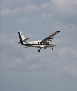
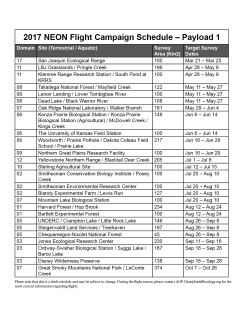
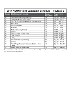
We are excited to announce the 2017 flight campaign schedule for NEON’s Airborne Observation Platform. The campaign will run from March to November, covering eighteen NEON domains with forty-three terrestrial sites and twenty-four aquatic sites using two payloads (scroll down for maps, tables and related KMZ files). The remote sensing instruments – consisting of an imaging spectrometer, a waveform light detection and ranging (LIDAR) instrument and a high-resolution digital camera – are mounted into a DeHavilland DHC-6 Twin Otter aircraft flying at a nominal altitude of 1000 m above ground level (AGL) at a speed of 100 knots. The flight parameters enable meter-scale spectroscopy, decimeter-scale photography, and ~4 points-per-meter discreet and waveform lidar measurements at a sufficient signal-to-noise ratio to retrieve vegetation vertical structure and biogeochemical properties from measured reflectance spectra.

At each terrestrial site a minimum of 100 km2 will be surveyed over an area encompassing the NEON tower airsheds and distributed long-term sampling plots, representative vegetation types, and watershed boundaries for both the terrestrial and aquatics sites. To minimize signal uncertainty due to plant phenology and to ensure spatial and temporal consistency in data products across multiple years, all terrestrial sites are scheduled to be flown during mean peak greenness, defined as the range of dates where MODIS NDVI is within 90% of the site maximum. To minimize atmospheric effects, data acquisition occurs at less than 10% cloud cover.

Planning your research in coordination with AOP flights

If you would like to plan research activities on the ground to coincide with AOP surveys of certain areas, please email us to join our mailing list. The NEON AOP flight operations team will email daily reports on the status of flights over each site which will be more accurate than the schedule posted in this article. Although the NEON AOP flight operations team will attempt adherence to the the published schedule, weather and logistical constraints may result in modifications to this plan.

Requests for NEON to fly additional areas

Due to the intensive nature of the NEON Flight Campaigns, we are unable to include additional flight areas to the existing plan. However, in 2018 we anticipate an additional payload will be available to support Principal Investigator (PI)-led science flights. You can learn more about how to make requests through our Assignable Assets Program. 

What data are available now?

NEON already provides freely available airborne data by request from our previous flight surveys. Explore what’s available on our Airborne Data page. There are also many other complementary data products that are downloadable from the [[nid:5909]].

Related maps, tables and KMZs


Share

Related Content:

Related Posts:

Discontinuation of Select NEON Data Products

January 29, 2026

Resolved: NEON AOP Lidar Data Quality Issues Due to Mis-Classified Atmospheric Noise

January 23, 2026

AOP Data Availability Notification – Release 2026

December 15, 2025

NSF NEON, Operated by Battelle

Follow Us:

Join Our Newsletter

Get updates on events, opportunities, and how NEON is being used today.

Subscribe Now

Footer

  • About Us
  • Contact Us
  • Terms & Conditions
  • Careers
  • Code of Conduct

Copyright © Battelle, 2026

The National Ecological Observatory Network is a major facility fully funded by the U.S. National Science Foundation.

Any opinions, findings and conclusions or recommendations expressed in this material do not necessarily reflect the views of the U.S. National Science Foundation.