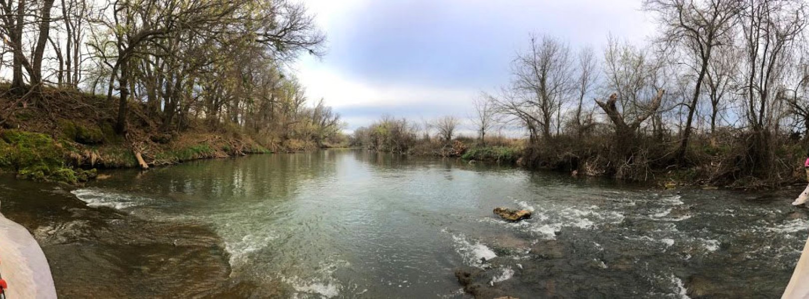
NSF NEON, Operated by Battelle

Main navigation

  • About
    • NEON Overview
      • Vision and Management
      • Spatial and Temporal Design
      • History
    • About the NEON Biorepository
      • ASU Biorepository Staff
      • Contact the NEON Biorepository
    • Observatory Blog
    • Newsletters
    • Staff
    • FAQ
    • Contact Us

    About

  • Data
    • Data Portal
      • Data Availability Charts
      • API & GraphQL
      • Prototype Data
      • Externally Hosted Data
    • Data Collection Methods
      • Airborne Observation Platform (AOP)
      • Instrument System (IS)
        • Instrumented Collection Types
        • Aquatic Instrument System (AIS)
        • Terrestrial Instrument System (TIS)
      • Observational System (OS)
        • Observation Types
        • Observational Sampling Design
        • Sampling Schedules
        • Taxonomic Lists Used by Field Staff
        • Optimizing the Observational Sampling Designs
      • Protocols & Standardized Methods
    • Getting Started with NEON Data
      • neonUtilities for R and Python
      • Learning Hub
      • Code Hub
    • Using Data
      • Data Formats and Conventions
      • Released, Provisional, and Revised Data
      • Data Product Bundles
      • Usage Policies
      • Acknowledging and Citing NEON
      • Publishing Research Outputs
    • Data Notifications
    • NEON Data Management
      • Data Availability
      • Data Processing
      • Data Quality

    Data

  • Samples & Specimens
    • Biorepository Sample Portal at ASU
    • About Samples
      • Sample Types
      • Sample Repositories
      • Megapit and Distributed Initial Characterization Soil Archives
    • Finding and Accessing Sample Data
      • Species Checklists
      • Sample Explorer - Relationships and Data
      • Biorepository API
    • Requesting and Using Samples
      • Loans & Archival Requests
      • Usage Policies

    Samples & Specimens

  • Field Sites
    • Field Site Map and Info
    • Spatial Layers & Printable Maps

    Field Sites

  • Resources
    • Getting Started with NEON Data
    • Research Support Services
      • Field Site Coordination
      • Letters of Support
      • Mobile Deployment Platforms
      • Permits and Permissions
      • AOP Flight Campaigns
      • Research Support FAQs
      • Research Support Projects
    • Code Hub
      • neonUtilities for R and Python
      • Code Resources Guidelines
      • Code Resources Submission
      • NEON's GitHub Organization Homepage
    • Learning Hub
      • Tutorials
      • Workshops & Courses
      • Science Videos
      • Teaching Modules
    • Science Seminars and Data Skills Webinars
    • Document Library
    • Funding Opportunities

    Resources

  • Impact
    • Research Highlights
    • Papers & Publications
    • NEON in the News

    Impact

  • Get Involved
    • Upcoming Events
    • Research and Collaborations
      • Environmental Data Science Innovation and Inclusion Lab
      • Collaboration with DOE BER User Facilities and Programs
      • EFI-NEON Ecological Forecasting Challenge
      • NEON Great Lakes User Group
      • NCAR-NEON-Community Collaborations
    • Advisory Groups
      • Science, Technology & Education Advisory Committee
      • Technical Working Groups
    • NEON Ambassador Program
      • Exploring NEON-Derived Data Products Workshop Series
    • Partnerships
    • Community Engagement
    • Work Opportunities

    Get Involved

  • My Account
  • Search

Search

Field Sites

  • Field Site Map and Info
  • Spatial Layers & Printable Maps

Breadcrumb

  1. Field Sites
  2. Blue River NEON

Field Site

Blue River NEON / BLUE

blue circle white drop icon

Gradient Aquatic, OK, D11: Southern Plains

Stream sampling at BLUE

About Field Sites

Blue River (BLUE) is an aquatic NEON field site located in southeastern Oklahoma at the Oka' Yanahili Preserve. The preserve is managed by The Nature Conservancy and protects nearly 14.5 km2 (3600 acres) of native prairie. The river drains a 322 km2 (124 sq. mi.) watershed. It originates in the Arbuckle Plains, an area characterized by limestone geology and gentle riffles and low waterfalls along the Blue River. BLUE is a bedrock-controlled channel and is undammed or otherwise controlled. The stream is mostly wadeable, with a few deeper sections that may be unwadeable at high water, and is wide with relatively high flow volume compared to other NEON sites. BLUE is part of NEON's Southern Plains Domain (D11), which stretches over the central sections of Texas and Oklahoma and includes portions of southern Kansas and southern New Mexico. D11 has three other NEON field sites, including two terrestrial and one additional aquatic site, located in Texas and Oklahoma. [1]

Climate

BLUE lies in the south Central Plains, a region that straddles the transition from relatively abundant precipitation in the east to semi-arid conditions in the west. The site has a mean average annual temperature of 16.4°C (62°F) and a mean average annual precipitation of 1041.1 mm (41 in.). Because the region is located in the interior of the United States, it experiences a wide range of temperatures seasonally and annually. Additionally, precipitation is highly variable from year to year; however, the majority of precipitation falls during the spring and summer months. Severe thunderstorms are common in the area, while tornadoes and severe drought periods also occur, but are not as common. [5] [6] [10]

Geology

The Blue River Gneiss is one of four main players in the composition of the Proterozoic basement in the Arbuckle Mountains. There are three compositional phases that make up the Gneiss, however, the rock type found most abundantly within the triad is a metaluminous biotite granite gneiss containing quartz, perthitic microcline, and plagioclase as the essential minerals. The metamorphic rock formations in this area are known for having particularly high color index. The USGS Mineral Database classifies the geology of this stream as alluvium. [2] [3]

Soils

Soil found at the site is considered to be a part of the Alfisoils category in the Western Cross Timbers region. It is typically loamy and humus-poor on gentle slopes (6%). [9]

Hydrology

BLUE is located on the Blue River, which flows for about 140 km (150 mi.) in a southern direction from its headwaters near Roff, OK to the Red River. More specifically, BLUE is situated on the perennial portion of Blue River near Connerville, OK. Perennial stream flow is sustained by discharge from the Arbuckle Simpson aquifer. BLUE has a relatively high flow, however, the stream does experience seasonal variability in flow, with higher stream flows during the spring and lower flows in summer. [1] [4]

Vegetation

Cacti (Cataceae) can be found within this region, along with various species of oak (Quercus spp.) trees and bluestem (Andropogon spp.) grasses. [7, 10]

Fauna

Fish include smallmouth (Micropterus dolomieu), spotted (Micropterus punctulatus), and largemouth (Micropterus salmoides) bass; crappie (Pomoxis spp.); catfish (Ictalurid spp.); and a varied community of panfish (Lepomis spp.). Trout (Oncorhynchus and Salvelinus spp.) are stocked in the Blue River at the designated fishing area, making it a designated Oklahoma trout stream from November to March. The area is home to several game species including bobwhite quail (Colinus virginianus), whitetail deer (Odocoileus virginianus), Rio Grande turkeys (Meleagris gallopavo), rabbits (Oryctolagus spp.), coyotes (Canis spp.), and bobcats (*Lynx spp.). [8]

Current Land Management and Use

The Blue River is managed by The Nature Conservancy, in partnership with the Oklahoma Department of Wildlife Conservation. The river is home to a popular fishing area which is stocked with trout once a year. NEON is the only organization performing research at this specific location. [8]

NEON Site Establishment

BLUE was first considered as a potential NEON site in June 2016. In January 2017, the site underwent a sampling readiness review (a form of audit to ensure the location was fit for NEON sampling). An initial operations review was performed at BLUE, and shortly thereafter sampling began. AOS sampling was the first form of NEON sampling to commence at BLUE in May 2017, followed by AIS sampling beginning November 2018.

Additional Resources

  1. Aquatic Instrument System (AIS) Site Characterization Report: Domain 11. NEON.DOC.002416vB
  2. Lidiak E.G., Denison R.E. (1999) Geology of the Blue River Gneiss, Eastern Arbuckle Mountains, Oklahoma. In: Sinha A.K. (eds) Basement Tectonics 13. Proceedings of the International Conferences on Basement Tectonics, vol 7. Springer, Dordrecht.
  3. U.S. Geological Survey, 2005, Mineral Resources Data System: U.S. Geological Survey, Reston, Virginia.
  4. Smith, Duane A. & Julie Cunningham. Oklahoma Water Resources Board. 2008.  Hydrologic Investigation of Blue River (Stream System 1-6), Technical Report 2008-01. 
  5. PRISM Climate Group, Oregon State University
  6. NOAA NCEI State Climate Summaries 2022: Oklahoma
  7. Oklahoma State University. Oklahoma's Native Vegetation Types
  8. Oklahoma Department of Wildlife Conservation, Blue River PFHA
  9. Carter, Brian J. & Mark S. Gregory. 2008. Soil Map of Oklahoma. Educational Publication 9, pg. 16. http://www.ogs.ou.edu/pubsscanned/EP9p16_19soil_veg_cl.pdf
  10. Hoagland, Bruce W. 2008. Vegetation of Oklahoma. Educational Publication 9, pg. 17. http://www.ogs.ou.edu/pubsscanned/EP9p16_19soil_veg_cl.pdf
  11. Johnson, Howard L. 2008. Climate of Oklahoma.  Educational Publication 9, pg. 18-19. http://www.ogs.ou.edu/pubsscanned/EP9p16_19soil_veg_cl.pdf

Field Site Information

Latitude/Longitude

34.444218, -96.624201

Geodetic Datum

WGS84

Location

Johnston County
OK, US

Elevation

Mean: 289m

Mean Annual Temperature

16.4°C

Dominant NLCD Classes

Grassland/Herbaceous, Pasture/Hay

Colocated Research

Oka'Yanahli Preserve

Field Operations Office

1200 South Woodrow, Suite 100
Denton, TX 76205

Research Access

If your proposed research requires access to field sites where NEON is present, we can help.

Request Access

Observation Types

Remote Sensing

Remote sensing surveys of this field site collect lidar, spectrometer and high-resolution RGB camera data.

Meteorological Measurements

This site has a meteorological station located in the riparian area of the stream that is outfitted with the a subset of the same sensors used at terrestrial sites. Measurements include wind speed and direction, air temperature, barometric pressure, relative humidity, shortwave radiation, and PAR.

Phenocams

A phenocam is pointed toward the land-water interface of the site. Here we show the images from the most recent hour. The full collection of images can be viewed on the Phenocam Gallery - click on the image below.

NEON.D11.BLUE.DP1.20002


Field Site Data

Site

Site Host

The Nature Conservancy Oklahoma

Site URL

https://www.nature.org/en-us/get-involved/how-to-help/places-we-protect/okayanahli-preserve/

Site Access Details

Please coordinate efforts with the site manager.

Operations Office

NEON Field Operations Office

Domain 11 Support Facility

NEON Field Operations Address

1200 South Woodrow, Suite 100
Denton, TX 76205

NEON Field Operations Phone

940.222.4259

Location

Latitude

34.444218

Longitude

-96.624201

Geodetic Datum

WGS84

UTM Northing

3813972.21m

UTM Easting

718273.98m

UTM Zone

14N

County

Johnston

State

OK

Country

US

Mean Elevation

289m

Climate

Mean Annual Temperature

16.4°C

Mean Annual Precipitation

1041mm

Vegetation

Dominant NLCD Classes

Grassland/Herbaceous, Pasture/Hay

Watershed

USGS HUC

h11140102

Watershed Name

Blue

Geology

USGS Geology Unit

OKQal;0

USGS Geology Name

Alluvium

USGS Lithologic Constituents

Unconsolidated clay, silt, sand and gravel

USGS Geology Age

Holocene


Gallery

  • Photos
  • Videos

No Video


Related Field Sites

Other Domain D11 Field Sites

brown square white mountain icon Lyndon B. Johnson National Grassland NEON
Core Terrestrial
brown circle white drop icon Marvin Klemme Range Research Station NEON
Gradient Terrestrial
blue square white drop icon Pringle Creek NEON
Core Aquatic

Other Field Sites in OK

brown circle white drop icon Marvin Klemme Range Research Station NEON
Gradient Terrestrial
NSF NEON, Operated by Battelle

Follow Us:

Join Our Newsletter

Get updates on events, opportunities, and how NEON is being used today.

Subscribe Now

Footer

  • About Us
  • Contact Us
  • Terms & Conditions
  • Careers
  • Code of Conduct

Copyright © Battelle, 2026

The National Ecological Observatory Network is a major facility fully funded by the U.S. National Science Foundation.

Any opinions, findings and conclusions or recommendations expressed in this material do not necessarily reflect the views of the U.S. National Science Foundation.