NSF NEON, Operated by Battelle

Main navigation

  • About
    • NEON Overview
      • Vision and Management
      • Spatial and Temporal Design
      • History
    • About the NEON Biorepository
      • ASU Biorepository Staff
      • Contact the NEON Biorepository
    • Observatory Blog
    • Newsletters
    • Staff
    • FAQ
    • Contact Us

    About

  • Data
    • Data Portal
      • Data Availability Charts
      • API & GraphQL
      • Prototype Data
      • Externally Hosted Data
    • Data Collection Methods
      • Airborne Observation Platform (AOP)
      • Instrument System (IS)
        • Instrumented Collection Types
        • Aquatic Instrument System (AIS)
        • Terrestrial Instrument System (TIS)
      • Observational System (OS)
        • Observation Types
        • Observational Sampling Design
        • Sampling Schedules
        • Taxonomic Lists Used by Field Staff
        • Optimizing the Observational Sampling Designs
      • Protocols & Standardized Methods
    • Getting Started with NEON Data
      • neonUtilities for R and Python
      • Learning Hub
      • Code Hub
    • Using Data
      • Data Formats and Conventions
      • Released, Provisional, and Revised Data
      • Data Product Bundles
      • Usage Policies
      • Acknowledging and Citing NEON
      • Publishing Research Outputs
    • Data Notifications
    • NEON Data Management
      • Data Availability
      • Data Processing
      • Data Quality

    Data

  • Samples & Specimens
    • Biorepository Sample Portal at ASU
    • About Samples
      • Sample Types
      • Sample Repositories
      • Megapit and Distributed Initial Characterization Soil Archives
    • Finding and Accessing Sample Data
      • Species Checklists
      • Sample Explorer - Relationships and Data
      • Biorepository API
    • Requesting and Using Samples
      • Loans & Archival Requests
      • Usage Policies

    Samples & Specimens

  • Field Sites
    • Field Site Map and Info
    • Spatial Layers & Printable Maps

    Field Sites

  • Resources
    • Getting Started with NEON Data
    • Research Support Services
      • Field Site Coordination
      • Letters of Support
      • Mobile Deployment Platforms
      • Permits and Permissions
      • AOP Flight Campaigns
      • Research Support FAQs
      • Research Support Projects
    • Code Hub
      • neonUtilities for R and Python
      • Code Resources Guidelines
      • Code Resources Submission
      • NEON's GitHub Organization Homepage
    • Learning Hub
      • Tutorials
      • Workshops & Courses
      • Science Videos
      • Teaching Modules
    • Science Seminars and Data Skills Webinars
    • Document Library
    • Funding Opportunities

    Resources

  • Impact
    • Research Highlights
    • Papers & Publications
    • NEON in the News

    Impact

  • Get Involved
    • Upcoming Events
    • Research and Collaborations
      • Environmental Data Science Innovation and Inclusion Lab
      • Collaboration with DOE BER User Facilities and Programs
      • EFI-NEON Ecological Forecasting Challenge
      • NEON Great Lakes User Group
      • NCAR-NEON-Community Collaborations
    • Advisory Groups
      • Science, Technology & Education Advisory Committee
      • Technical Working Groups
    • NEON Ambassador Program
      • Exploring NEON-Derived Data Products Workshop Series
    • Partnerships
    • Community Engagement
    • Work Opportunities

    Get Involved

  • My Account
  • Search

Search

About

  • NEON Overview
  • About the NEON Biorepository
  • Observatory Blog
  • Newsletters
  • Staff
  • FAQ
  • Contact Us

Breadcrumb

  1. About
  2. Observatory Blog
  3. AOP Data Availability Notification – Release 2024

Data Notification

AOP Data Availability Notification – Release 2024

December 20, 2023

As part of the upcoming 2024 NEON Annual Release, AOP will be updating data products with known data quality issues (Table 1) as well as re-generating the Ecosystem Structure Lidar data product (DP3.30015.001 - Canopy Height Model / CHM) with an improved implementation of the original algorithm (continue reading for more details). We plan to update the CHM data product for all sites and years. The majority of data quality-related updates pertain to misclassified point clouds, which resulted in artifacts with the derived L3 lidar products (all raster models: DTM, DSM, CHM, Slope, and Aspect), as well as orthorectification errors in the RGB Camera and Spectrometer Reflectance and Radiance data products. For most cases, only a small portion of each site was impacted. Data products that will be updated due to misclassified noise are DP1.30003.001, DP1.30006.001, DP3.30006.001, DP1.30008.001, DP1.30010.001, DP3.30010.001, DP3.30003.001,  DP3.30024.001, and DP3.30025.001. Please refer to the data product issue logs on the Data Portal for additional details. 

There will be an approximately month-long transition period between Release-2023 and Release-2024 where files comprising the data products we are updating will first be temporarily unavailable from the Data Portal, and then replaced with the updated data products between December 20, 2023 and ~January 15, 2024. Once this process begins, Release-2023 will no longer be available in its original state, nor will it be static. We recommend holding off on downloading AOP data during this transition period, or using the Contact Us form to request the status of any specific AOP data product(s), site(s), and year(s). The 2024 Release is estimated to be complete by the end of January 2024, and at that time, all AOP data from the 2023 Release will be “Tombstoned” and superseded by Release-2024. The Release-2023 DOIs will still resolve to the same landing webpages, but the older data versions will no longer be available to download. Users will be referred to the latest Release.

For more information on the release process as it pertains to AOP, please refer to NEON's Data Product Revisions and Releases page.

Table 1: Planned sites and publication dates that will undergo AOP data quality updates due to misclassified noise in the L1 point cloud data, causing artifacts in the derived L3 lidar products. Data products to be updated are DP1.30003.001, DP1.30006.001, DP3.30006.001, DP1.30008.001, DP1.30010.001, DP3.30010.001, DP3.30003.001,  DP3.30024.001, and DP3.30025.001.
SITE PUBLICATION YEAR-MONTH
CHEQ (STEI) 2020-08
PUUM 2019-01
UKFS 2019-05
CLBJ 2018-04

Updated Canopy Height Model Algorithm

NEON implements a pit-free CHM algorithm, following Khosravipour et al. 2014, as described in the Ecosystem Structure Algorithm Theoretical Basis Document (ATBD). CHMs generated by differencing the Digital Terrain Model from the Digital Surface model typically result in "pits" under trees, which occur when "laser beams penetrate deeply into a tree crown, hitting a lower branch or the ground before producing the first return". The Khosravipour algorithm uses subsets of the lidar points to close these pits. Up until 2023, NEON has used 5 m subset intervals, which removed the pits, but resulted in artifacts, most clearly visualized in the distribution of the Canopy Height Model values (Figure 1a). Starting in 2023, NEON started using 0.1 m subsets, resulting in a smoother and more accurate distribution of height values (Figure 1b). The differences in CHMs generated with the old and new algorithm are expected to be relatively small, although values may differ along the edges of trees, for example (Figure 2). For the 2024 Release, we are re-processing the full archive of Ecosystem Structure (DP3.30015.001) data to produce models generated with this improved implementation of the algorithm. 
 

histograms

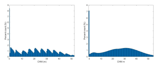
Figure 1. Histograms of the NEON Canopy Height Models (CHMs) at the ABBY site generated with the older implementation of the pit-free algorithm, using a) 5 m subsets (left) and with b) the newer implementation of the algorithm, using 0.01 m subsets (right).

map

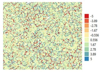
Figure 2. Difference between Canopy Height Model generated with the pit-free algorithm using 5 m and 0.01 m subsets.

Please use the Contact Us form for further inquiries regarding the updated CHM algorithm or the AOP release process, and include the term 'AOP 2024 Release Updates' in the body of your request.

References

Khosravipour, A., Skidmore, A. K., Isenburg, M., Wang, T., and Hussin, Y. A. (2014). Generating pit-free canopy height models from airborne lidar, Photogrammetric Engineering and Remote Sensing, 80(9), 863-872. DOI:10.14358/PERS.80.9.863
 

Share

Related Posts:

Discontinuation of Select NEON Data Products

January 29, 2026

Resolved: NEON AOP Lidar Data Quality Issues Due to Mis-Classified Atmospheric Noise

January 23, 2026

AOP Data Availability Notification – Release 2026

December 15, 2025

NSF NEON, Operated by Battelle

Follow Us:

Join Our Newsletter

Get updates on events, opportunities, and how NEON is being used today.

Subscribe Now

Footer

  • About Us
  • Contact Us
  • Terms & Conditions
  • Careers
  • Code of Conduct

Copyright © Battelle, 2026

The National Ecological Observatory Network is a major facility fully funded by the U.S. National Science Foundation.

Any opinions, findings and conclusions or recommendations expressed in this material do not necessarily reflect the views of the U.S. National Science Foundation.