NSF NEON, Operated by Battelle

Main navigation

  • About
    • NEON Overview
      • Vision and Management
      • Spatial and Temporal Design
      • History
    • About the NEON Biorepository
      • ASU Biorepository Staff
      • Contact the NEON Biorepository
    • Observatory Blog
    • Newsletters
    • Staff
    • FAQ
    • Contact Us

    About

  • Data
    • Data Portal
      • Data Availability Charts
      • API & GraphQL
      • Prototype Data
      • Externally Hosted Data
    • Data Collection Methods
      • Airborne Observation Platform (AOP)
      • Instrument System (IS)
        • Instrumented Collection Types
        • Aquatic Instrument System (AIS)
        • Terrestrial Instrument System (TIS)
      • Observational System (OS)
        • Observation Types
        • Observational Sampling Design
        • Sampling Schedules
        • Taxonomic Lists Used by Field Staff
        • Optimizing the Observational Sampling Designs
      • Protocols & Standardized Methods
    • Getting Started with NEON Data
      • neonUtilities for R and Python
      • Learning Hub
      • Code Hub
    • Using Data
      • Data Formats and Conventions
      • Released, Provisional, and Revised Data
      • Data Product Bundles
      • Usage Policies
      • Acknowledging and Citing NEON
      • Publishing Research Outputs
    • Data Notifications
    • NEON Data Management
      • Data Availability
      • Data Processing
      • Data Quality

    Data

  • Samples & Specimens
    • Biorepository Sample Portal at ASU
    • About Samples
      • Sample Types
      • Sample Repositories
      • Megapit and Distributed Initial Characterization Soil Archives
    • Finding and Accessing Sample Data
      • Species Checklists
      • Sample Explorer - Relationships and Data
      • Biorepository API
    • Requesting and Using Samples
      • Loans & Archival Requests
      • Usage Policies

    Samples & Specimens

  • Field Sites
    • Field Site Map and Info
    • Spatial Layers & Printable Maps

    Field Sites

  • Resources
    • Getting Started with NEON Data
    • Research Support Services
      • Field Site Coordination
      • Letters of Support
      • Mobile Deployment Platforms
      • Permits and Permissions
      • AOP Flight Campaigns
      • Research Support FAQs
      • Research Support Projects
    • Code Hub
      • neonUtilities for R and Python
      • Code Resources Guidelines
      • Code Resources Submission
      • NEON's GitHub Organization Homepage
    • Learning Hub
      • Tutorials
      • Workshops & Courses
      • Science Videos
      • Teaching Modules
    • Science Seminars and Data Skills Webinars
    • Document Library
    • Funding Opportunities

    Resources

  • Impact
    • Research Highlights
    • Papers & Publications
    • NEON in the News

    Impact

  • Get Involved
    • Upcoming Events
    • Research and Collaborations
      • Environmental Data Science Innovation and Inclusion Lab
      • Collaboration with DOE BER User Facilities and Programs
      • EFI-NEON Ecological Forecasting Challenge
      • NEON Great Lakes User Group
      • NCAR-NEON-Community Collaborations
    • Advisory Groups
      • Science, Technology & Education Advisory Committee
      • Technical Working Groups
    • NEON Ambassador Program
      • Exploring NEON-Derived Data Products Workshop Series
    • Partnerships
    • Community Engagement
    • Work Opportunities

    Get Involved

  • My Account
  • Search

Search

About

  • NEON Overview
  • About the NEON Biorepository
  • Observatory Blog
  • Newsletters
  • Staff
  • FAQ
  • Contact Us

Breadcrumb

  1. About
  2. Observatory Blog
  3. NEON Terrestrial Observation System (TOS) Base plot subplot renaming

Data Notification

NEON Terrestrial Observation System (TOS) Base plot subplot renaming

October 6, 2023

The NEON naming convention for subplots within Base plots, at which several Terrestrial Observation (TOS) protocols are implemented, is being changed to clarify the location of data collection. The new format consists of the identity of the plot point in the southwest corner of the subplot, the scale or size of the subplot, and, for those subplots smaller than 100 m2, the corner of the 100 m2 subplot in which the smaller subplot is located. For example, ‘21_400’ refers to point 21 in the southwest corner and is 400 m2 (20 m x 20 m), and ‘31_1_1’ is a subplot with point 31 in the southwest corner, is 1 m2, and is in corner 1 of the 100 m2 subplot with point 31 in the southwest corner.

TOS Base plot subplot renaming changes

The naming convention of all subplots within Base plots will now include the size or scale of the subplot and, for those subplots smaller than 100 m2, the corner of the 100 m2 subplot in which the smaller subplot is located. The format is: the point in the southwest corner, scale or size of the subplot, and (if applicable) the corner of the 100 m2 subplot (e.g., ‘21_400’ or ‘41_10_2’, Figure 1 and 2).

Previously, subplots of 100 m2 or 400 m2 were identified by the point in the southwest corner of the subplot (e.g., ‘21’ or ‘41’). Subplots smaller than 100 m2 were previously named according to the point in the southwest corner of the 100 m2 subplot, the subplot corner, and the scale (e.g., ‘41.2.10’). Differences are:

  1. The inclusion of scale in all subplotIDs; what was ‘21’ will be ‘21_400’,
  2. The change in location of the subplot scale or size and the identifying corner in the subplot string for subplots smaller than 100 m2, and
  3. String components are now separated by an underscore (“_”) instead of a period (“.”); what was subplot ‘31.1.10’ will become ‘31_10_1’.

When changes will occur

The change will be reflected in Provisional data starting in mid-November 2023; it will appear in all data in the 2024 Release and subsequent Provisional data and data Releases. RELEASE-2021, -2022, and -2023 data contain the prior naming convention and will not change.

Sites affected

The change will happen at all Base plots at all NEON terrestrial sites.

Impacted data products

  • Herbaceous clip harvest (DP1.10023.001)
  • Litterfall and fine woody debris production and chemistry (DP1.10033.001)
  • Plant foliar traits (DP1.10026.001)
  • Plant presence and percent cover (DP1.10058.001)
  • Root biomass and chemistry, periodic (DP1.10067.001)
  • Soil physical and chemical properties, periodic (DP1.10086.001)
  • Vegetation structure (DP1.10098.001)

Impacted code resources

neonUtilities and neonOS are unaffected by this change, and operate as usual on both the new and deprecated naming conventions. geoNEON will be updated to operate smoothly on both.

Graphic of base plots

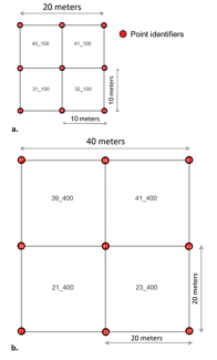
Figure 1. The new Terrestrial Observation System (TOS) Base plot subplot naming convention is formatted as southwest corner pointID_scale for subplots of 400 m2 and 100m2. For example, subplot ‘21_400’ is a 400 m2 subplot bounded by the point identifiers 21, 23, 39, and 41 (b). Subplot ‘21_100’ is 100 m2 and is bounded by the points 21, 22, 30, and 31 (b). Subplot ‘31_100’ is 100 m2 and is bounded by the points 31, 32, 40, and 41 (a).

Graphic of base plots new

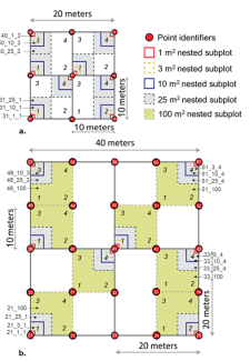
Figure 2. The new TOS Base plot subplot naming convention for subplots smaller than 100 m2 is defined by the southwest corner pointID_scale_corner. Corner is the corner of the 100 m2 subplot in which they reside, labeled 1-4 in italics (a and b) . Subplot ‘31_10_1’ is located within subplot ‘31_100’, is 10 m2 in size, and is in corner 1 of 31_100 (a). Subplot ‘51_25_4’ is in ‘51_100’, is 25 m2, and is in corner 4 of ‘51_100’.

Share

Related Posts:

Discontinuation of Select NEON Data Products

January 29, 2026

Modification of Select NEON Data Products

January 29, 2026

Shortwave Radiation tables temporarily removed from Summary Weather Statistics

January 12, 2026

NSF NEON, Operated by Battelle

Follow Us:

Join Our Newsletter

Get updates on events, opportunities, and how NEON is being used today.

Subscribe Now

Footer

  • About Us
  • Contact Us
  • Terms & Conditions
  • Careers
  • Code of Conduct

Copyright © Battelle, 2026

The National Ecological Observatory Network is a major facility fully funded by the U.S. National Science Foundation.

Any opinions, findings and conclusions or recommendations expressed in this material do not necessarily reflect the views of the U.S. National Science Foundation.