NSF NEON, Operated by Battelle

Main navigation

  • About
    • NEON Overview
      • Vision and Management
      • Spatial and Temporal Design
      • History
    • About the NEON Biorepository
      • ASU Biorepository Staff
      • Contact the NEON Biorepository
    • Observatory Blog
    • Newsletters
    • Staff
    • FAQ
    • Contact Us

    About

  • Data
    • Data Portal
      • Data Availability Charts
      • API & GraphQL
      • Prototype Data
      • Externally Hosted Data
    • Data Collection Methods
      • Airborne Observation Platform (AOP)
      • Instrument System (IS)
        • Instrumented Collection Types
        • Aquatic Instrument System (AIS)
        • Terrestrial Instrument System (TIS)
      • Observational System (OS)
        • Observation Types
        • Observational Sampling Design
        • Sampling Schedules
        • Taxonomic Lists Used by Field Staff
        • Optimizing the Observational Sampling Designs
      • Protocols & Standardized Methods
    • Getting Started with NEON Data
      • neonUtilities for R and Python
      • Learning Hub
      • Code Hub
    • Using Data
      • Data Formats and Conventions
      • Released, Provisional, and Revised Data
      • Data Product Bundles
      • Usage Policies
      • Acknowledging and Citing NEON
      • Publishing Research Outputs
    • Data Notifications
    • NEON Data Management
      • Data Availability
      • Data Processing
      • Data Quality

    Data

  • Samples & Specimens
    • Biorepository Sample Portal at ASU
    • About Samples
      • Sample Types
      • Sample Repositories
      • Megapit and Distributed Initial Characterization Soil Archives
    • Finding and Accessing Sample Data
      • Species Checklists
      • Sample Explorer - Relationships and Data
      • Biorepository API
    • Requesting and Using Samples
      • Loans & Archival Requests
      • Usage Policies

    Samples & Specimens

  • Field Sites
    • Field Site Map and Info
    • Spatial Layers & Printable Maps

    Field Sites

  • Resources
    • Getting Started with NEON Data
    • Research Support Services
      • Field Site Coordination
      • Letters of Support
      • Mobile Deployment Platforms
      • Permits and Permissions
      • AOP Flight Campaigns
      • Research Support FAQs
      • Research Support Projects
    • Code Hub
      • neonUtilities for R and Python
      • Code Resources Guidelines
      • Code Resources Submission
      • NEON's GitHub Organization Homepage
    • Learning Hub
      • Tutorials
      • Workshops & Courses
      • Science Videos
      • Teaching Modules
    • Science Seminars and Data Skills Webinars
    • Document Library
    • Funding Opportunities

    Resources

  • Impact
    • Research Highlights
    • Papers & Publications
    • NEON in the News

    Impact

  • Get Involved
    • Upcoming Events
    • Research and Collaborations
      • Environmental Data Science Innovation and Inclusion Lab
      • Collaboration with DOE BER User Facilities and Programs
      • EFI-NEON Ecological Forecasting Challenge
      • NEON Great Lakes User Group
      • NCAR-NEON-Community Collaborations
    • Advisory Groups
      • Science, Technology & Education Advisory Committee
      • Technical Working Groups
    • NEON Ambassador Program
      • Exploring NEON-Derived Data Products Workshop Series
    • Partnerships
    • Community Engagement
    • Work Opportunities

    Get Involved

  • My Account
  • Search

Search

About

  • NEON Overview
  • About the NEON Biorepository
  • Observatory Blog
  • Newsletters
  • Staff
  • FAQ
  • Contact Us

Breadcrumb

  1. About
  2. Observatory Blog
  3. NEON data quantifies topographic change caused by 2013 Boulder flood

NEON data quantifies topographic change caused by 2013 Boulder flood

March 11, 2015

Bear Peak in Boulder Colorado

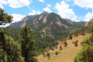
In September 2013, Boulder, CO experienced a seven day storm event which resulted in an accumulated rainfall greater than the yearly average: the unprecedented rainfall caused severe flooding and devastation across the northern Front Range of Colorado.

Prior to the storm event, on June 26-27, 2013, the National Ecological Observatory Network (NEON) conducted an airborne remote sensing survey of Boulder as part of yearly test flights. Shortly after the flood subsided, on October 8, 2013, NEON conducted a second airborne flight of the same area. Given the timing of the flights, the pre-flood and post-flood surveys present a distinct dataset that may be used to evaluate topographic change driven by a severe storm event.

Surveys were conducted with the NEON Airborne Observation Platform (AOP), which contains a Light Detection and Ranging (LiDAR) sensor, high-resolution digital camera and an imaging spectrometer mounted in a Twin otter aircraft. The LiDAR sensor provides detailed information about topography and vegetation, critical for assessing changes in landscape. To learn more about LiDAR, check out NEON’s LiDAR-related science videos.

NEON produced pre-flood and post-flood high resolution digital topographic maps, or Digital Terrain Models (DTMs), of the ground surface using information collected from the LiDAR sensor. NEON compared the pre-flood and post-flood maps to quantify changes in elevation and vegetation. 

Since this unique dataset provides information about how the storm event impacted a specific area, mapping topographic and vegetative changes may inform local mitigation planning and disaster risk reduction efforts. However, topographic change over time and across the continent is more difficult to interpret. Using standardized collection methods over a projected timespan of 30 years, in combination with other ground data, NEON airborne data will measure changes in our landscape and improve our understanding and forecasting of ecological change.

For more information on LiDAR data acquisition parameters, data processing methods and determination of topographic change of the Boulder flood, please review TM-006: NEON AOP Surveys of City of Boulder Pre and Post 2013 Flood Event. The pre-flood and post-flood data airborne data are available through the NEON website upon request.

Update: Use this data in your classroom to teach about ecological disturbances! Teaching Module: Quantifying The Drivers and Impacts of Natural Disturbance Events – The 2013 Colorado Floods


Share

Related Posts:

Discontinuation of Select NEON Data Products

January 29, 2026

Resolved: NEON AOP Lidar Data Quality Issues Due to Mis-Classified Atmospheric Noise

January 23, 2026

AOP Data Availability Notification – Release 2026

December 15, 2025

NSF NEON, Operated by Battelle

Follow Us:

Join Our Newsletter

Get updates on events, opportunities, and how NEON is being used today.

Subscribe Now

Footer

  • About Us
  • Contact Us
  • Terms & Conditions
  • Careers
  • Code of Conduct

Copyright © Battelle, 2026

The National Ecological Observatory Network is a major facility fully funded by the U.S. National Science Foundation.

Any opinions, findings and conclusions or recommendations expressed in this material do not necessarily reflect the views of the U.S. National Science Foundation.