NSF NEON, Operated by Battelle

Main navigation

  • About
    • NEON Overview
      • Vision and Management
      • Spatial and Temporal Design
      • History
    • About the NEON Biorepository
      • ASU Biorepository Staff
      • Contact the NEON Biorepository
    • Observatory Blog
    • Newsletters
    • Staff
    • FAQ
    • Contact Us

    About

  • Data
    • Data Portal
      • Data Availability Charts
      • API & GraphQL
      • Prototype Data
      • Externally Hosted Data
    • Data Collection Methods
      • Airborne Observation Platform (AOP)
      • Instrument System (IS)
        • Instrumented Collection Types
        • Aquatic Instrument System (AIS)
        • Terrestrial Instrument System (TIS)
      • Observational System (OS)
        • Observation Types
        • Observational Sampling Design
        • Sampling Schedules
        • Taxonomic Lists Used by Field Staff
        • Optimizing the Observational Sampling Designs
      • Protocols & Standardized Methods
    • Getting Started with NEON Data
      • neonUtilities for R and Python
      • Learning Hub
      • Code Hub
    • Using Data
      • Data Formats and Conventions
      • Released, Provisional, and Revised Data
      • Data Product Bundles
      • Usage Policies
      • Acknowledging and Citing NEON
      • Publishing Research Outputs
    • Data Notifications
    • NEON Data Management
      • Data Availability
      • Data Processing
      • Data Quality

    Data

  • Samples & Specimens
    • Biorepository Sample Portal at ASU
    • About Samples
      • Sample Types
      • Sample Repositories
      • Megapit and Distributed Initial Characterization Soil Archives
    • Finding and Accessing Sample Data
      • Species Checklists
      • Sample Explorer - Relationships and Data
      • Biorepository API
    • Requesting and Using Samples
      • Loans & Archival Requests
      • Usage Policies

    Samples & Specimens

  • Field Sites
    • Field Site Map and Info
    • Spatial Layers & Printable Maps

    Field Sites

  • Resources
    • Getting Started with NEON Data
    • Research Support Services
      • Field Site Coordination
      • Letters of Support
      • Mobile Deployment Platforms
      • Permits and Permissions
      • AOP Flight Campaigns
      • Research Support FAQs
      • Research Support Projects
    • Code Hub
      • neonUtilities for R and Python
      • Code Resources Guidelines
      • Code Resources Submission
      • NEON's GitHub Organization Homepage
    • Learning Hub
      • Tutorials
      • Workshops & Courses
      • Science Videos
      • Teaching Modules
    • Science Seminars and Data Skills Webinars
    • Document Library
    • Funding Opportunities

    Resources

  • Impact
    • Research Highlights
    • Papers & Publications
    • NEON in the News

    Impact

  • Get Involved
    • Upcoming Events
    • Research and Collaborations
      • Environmental Data Science Innovation and Inclusion Lab
      • Collaboration with DOE BER User Facilities and Programs
      • EFI-NEON Ecological Forecasting Challenge
      • NEON Great Lakes User Group
      • NCAR-NEON-Community Collaborations
    • Advisory Groups
      • Science, Technology & Education Advisory Committee
      • Technical Working Groups
    • NEON Ambassador Program
      • Exploring NEON-Derived Data Products Workshop Series
    • Partnerships
    • Community Engagement
    • Work Opportunities

    Get Involved

  • My Account
  • Search

Search

Get Involved

  • Upcoming Events
  • Research and Collaborations
  • Advisory Groups
  • NEON Ambassador Program
  • Partnerships
  • Community Engagement
  • Work Opportunities

Breadcrumb

  1. Get Involved
  2. Upcoming Events
  3. 2017 IEEE International Geoscience and Remote Sensing Symposium

Event - Conference/Meeting

2017 IEEE International Geoscience and Remote Sensing Symposium

Jul 23 - 28 2017 | All day

Twin Otter arrival at KBDU

Join us for an airborne remote sensing tutorial at IGARSS 2017!

The tutorial (tutorial FD5 on IGARSS 2017 website) will include several speakers who will detail the design, implementation and lessons learned in reaching operational capacity of the Airborne Observation Platform (AOP) to support NEON.

Talks will focus on the following:

  • An overview of the NEON project and the synergy of the AOP observations with other ecological observations acquired by NEON
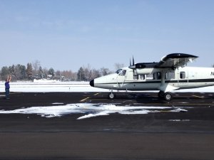
  • Introduction to the AOP sensors and payload
  • Mission planning and flight design with emphasis on coordinating flights to observe all sites during peak greenness and in fair weather, as well as site-level flight plan design considerations
  • Calibration of the imaging spectrometer to provide consistent repeatable observations across differing payloads and yearly campaigns
  • The algorithms and workflows selected for producing remote sensing data products which will support the mission of NEON
  • Quantification of data product uncertainty introduced by the sensors, flight acquisition parameters, and algorithmic choices
  • File formats used to distribute the data
  • How NEON data from all parts of the observatory can be accessed by the public to support research endeavors

Participants will gain a fundamental understanding of the NEON mission, details on technical aspects of the AOP, familiarity with NEON AOP products, and potential research avenues for furthering ecological applications of remote sensing data.

Learn More

Location:

United States

NSF NEON, Operated by Battelle

Follow Us:

Join Our Newsletter

Get updates on events, opportunities, and how NEON is being used today.

Subscribe Now

Footer

  • About Us
  • Contact Us
  • Terms & Conditions
  • Careers
  • Code of Conduct

Copyright © Battelle, 2026

The National Ecological Observatory Network is a major facility fully funded by the U.S. National Science Foundation.

Any opinions, findings and conclusions or recommendations expressed in this material do not necessarily reflect the views of the U.S. National Science Foundation.