NSF NEON, Operated by Battelle

Main navigation

  • About
    • NEON Overview
      • Vision and Management
      • Spatial and Temporal Design
      • History
    • About the NEON Biorepository
      • ASU Biorepository Staff
      • Contact the NEON Biorepository
    • Observatory Blog
    • Newsletters
    • Staff
    • FAQ
    • Contact Us

    About

  • Data
    • Data Portal
      • Data Availability Charts
      • API & GraphQL
      • Prototype Data
      • Externally Hosted Data
    • Data Collection Methods
      • Airborne Observation Platform (AOP)
      • Instrument System (IS)
        • Instrumented Collection Types
        • Aquatic Instrument System (AIS)
        • Terrestrial Instrument System (TIS)
      • Observational System (OS)
        • Observation Types
        • Observational Sampling Design
        • Sampling Schedules
        • Taxonomic Lists Used by Field Staff
        • Optimizing the Observational Sampling Designs
      • Protocols & Standardized Methods
    • Getting Started with NEON Data
      • neonUtilities for R and Python
      • Learning Hub
      • Code Hub
    • Using Data
      • Data Formats and Conventions
      • Released, Provisional, and Revised Data
      • Data Product Bundles
      • Usage Policies
      • Acknowledging and Citing NEON
      • Publishing Research Outputs
    • Data Notifications
    • NEON Data Management
      • Data Availability
      • Data Processing
      • Data Quality

    Data

  • Samples & Specimens
    • Biorepository Sample Portal at ASU
    • About Samples
      • Sample Types
      • Sample Repositories
      • Megapit and Distributed Initial Characterization Soil Archives
    • Finding and Accessing Sample Data
      • Species Checklists
      • Sample Explorer - Relationships and Data
      • Biorepository API
    • Requesting and Using Samples
      • Loans & Archival Requests
      • Usage Policies

    Samples & Specimens

  • Field Sites
    • Field Site Map and Info
    • Spatial Layers & Printable Maps

    Field Sites

  • Resources
    • Getting Started with NEON Data
    • Research Support Services
      • Field Site Coordination
      • Letters of Support
      • Mobile Deployment Platforms
      • Permits and Permissions
      • AOP Flight Campaigns
      • Research Support FAQs
      • Research Support Projects
    • Code Hub
      • neonUtilities for R and Python
      • Code Resources Guidelines
      • Code Resources Submission
      • NEON's GitHub Organization Homepage
    • Learning Hub
      • Tutorials
      • Workshops & Courses
      • Science Videos
      • Teaching Modules
    • Science Seminars and Data Skills Webinars
    • Document Library
    • Funding Opportunities

    Resources

  • Impact
    • Research Highlights
    • Papers & Publications
    • NEON in the News

    Impact

  • Get Involved
    • Upcoming Events
    • Research and Collaborations
      • Environmental Data Science Innovation and Inclusion Lab
      • Collaboration with DOE BER User Facilities and Programs
      • EFI-NEON Ecological Forecasting Challenge
      • NEON Great Lakes User Group
      • NCAR-NEON-Community Collaborations
    • Advisory Groups
      • Science, Technology & Education Advisory Committee
      • Technical Working Groups
    • NEON Ambassador Program
      • Exploring NEON-Derived Data Products Workshop Series
    • Partnerships
    • Community Engagement
    • Work Opportunities

    Get Involved

  • My Account
  • Search

Search

Field Sites

  • Field Site Map and Info
  • Spatial Layers & Printable Maps

Breadcrumb

  1. Field Sites
  2. Prairie Lake NEON

Field Site

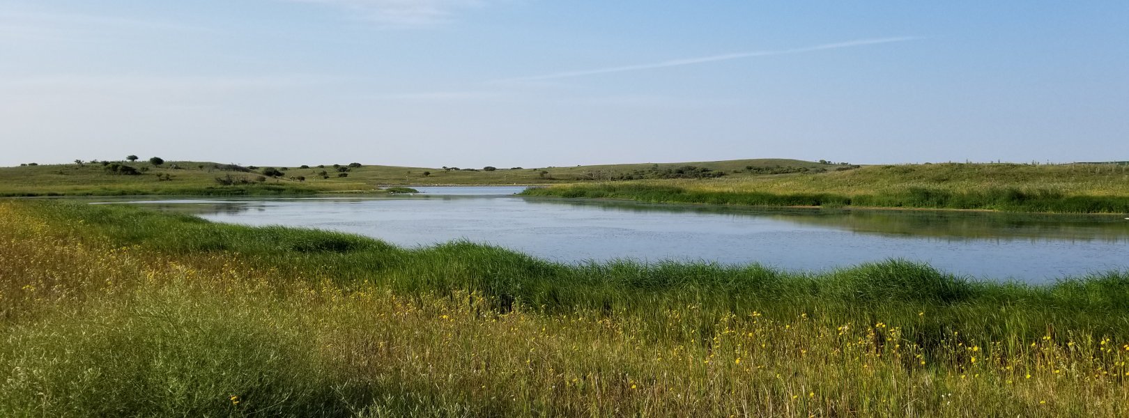
Prairie Lake NEON / PRLA

blue circle white drop icon

Gradient Aquatic, ND, D09: Northern Plains

PRLA in the summer

About Field Sites

Prairie Lake (PRLA) is an aquatic NEON field site located on the Missouri Coteau approximately 15 km (9.3 mi.) west of Pingree, North Dakota. PRLA sits in a 4.5 km2 (1112 acre) watershed, on land managed by the State of North Dakota Land Trust. The region includes a patchwork of grasslands, agricultural, and wetland/aquatic communities embedded in a matrix of small agrarian communities. The landscape at PRLA is characterized by rolling hills covered in mixed-grass prairie with a high concentration of wetlands. This site is part of NEON's Northern Plains Domain (D09). D09 has one other aquatic field site and three terrestrial field sites. PRLA is colocated with the Dakota Coteau Field School (DCFS) terrestrial field site. [2] [5]

Climate

Climate in the region is continental, with wide-ranging temperature fluctuations both daily and seasonally. The area experiences temperature extremes, with bitterly cold temperatures in the winter and very hot temperatures in the summer. The lack of mountain ranges in the state allows for cold arctic air masses to drop into the state during the winter, bringing bitter cold spells. The mean annual temperature in the vicinity is 4.9°C (40.8°F)and mean annual precipitation is 489 mm (3.5 in.). Precipitation varies from year to year, with more precipitation falling during the summer months when thunderstorm activity is the highest. Weather exhibits extreme variability, with periodic droughts, hailstorms, fluctuations in temperature, and frequent strong winds. The most severe storms can produce hail, tornadoes, or damaging straight-line winds. [3] [9] [10]

Geology

The Missouri Coteau is the geologic feature that extends from east-central South Dakota through southwestern Saskatchewan. The Coteau rises 91-152 m (~300-500 ft.) above the Drift Plain to the east. It has a hilly landscape composed of knobs and kettles, which in turn are comprised of glacial till. There is also glaciofluvial material found in the area which was deposited by the stagnation of glacial ice. The geology at this site is characterized by glacial sediments of mud, clay and silt. More specifically, the parent materials are mostly Wisconsin age, fine-loamy glacial till, and alluvium derived from the till. In addition to the till, the northeastern section of the site consists of sandy and gravelly glacial outwash. [3] [6] [8]

Soils

The soil order at this site is Mollisol. The soil family is fine-loamy, mixed, superactive, frigid Typic Haplustolls. [8]

Hydrology

The area surrounding PRLA is a matrix of small lakes, ponds, and ephemeral prairie potholes. PRLA is a small "terminal wetland" lake, containing mostly sand substrate, with some macrophytes (sedges) and few areas of pebble/cobble. The bank material at the lake is peat and sedges. [4] [5]

Vegetation

The Northern Plains Domain is dominated by prairie grasslands, including a combination of short and mid-stature grasses, and croplands. The riparian vegetation at PRLA is primarily composed of grasses and occasional trees. The surrounding area is dominated by Kentucky blue grass (Poa pretensis (L.)), silverberry (Elaeagnus commutate), and fireberry hawthorn (Crataegus chrysocarpa). [4] [5]

Fauna

Common mammals of the prairie pothole region include Coyote (Canis latrans), white-tailed deer (Odocoileus virginianus), muskrat (Ondatra zibethicus), raccoon (Procyon lotor), and multiple species of mustelids. There are also cattle present on the landscape immediately surrounding PRLA. The prairie pothole region is an important environment for breeding water fowl and other migratory birds. The area plays host to dabbling and diving ducks; as well as various species of grebe, mergansers, shore birds, geese, and song birds. Wetlands in the area are home to turtles, non-game fish, macro invertebrates, and some amphibian species. NEON conducts electrofishing, macroinvertebrate, and zooplankton sampling protocols at the PRLA site. [1]

Past Land Management and Use

Native American presence in the area dates back to 10,000 years ago, following the retreat of the continental glaciers. Before European settlers arrived, the Dakota or Lakota nation, as well as the Assiniboine, Cheyenne, Mandan, Hidatsa, and Arikara groups were present in what is now North Dakota. Native Americans and Euro-Americans came into contact in the 18th Century and further American settlement commenced in 1861 following the establishment of North Dakota as a territory. In 1889, when North Dakota became a state, the federal government gifted more than 12140 km2 (3 million acres) of land to the state through the Enabling Act. The land was to be held in trust for the purpose of funding public education in the state, and was established in every North Dakota township for this purpose. Public schools were built on some parcels of land, and others were used to generate funds for schools through selling mineral rights or leasing land to local farmers for grazing. The land at this site has been transformed by agricultural activities over the last 150 years; it has no record of historical tilling. [4] [11] [12]

Current Land Management and Use

Currently the PRLA is managed by the North Dakota Department of Trust Lands and is rented out to private citizens. One quarter section north of the lake is hayed while the rest of the land is grazed by cattle. [5] [7]

NEON Site Establishment

Establishment for PRLA started in early 2014, with observation sampling starting in late 2014. Aquatic sensing was fully operational in mid-2017.

Additional Resources

[1] Herman, Gwyn. Johnson, Laverne. (2008) Habitats of North Dakota: Wetlands. North Dakota Game and Fish Department

[2] https://gf.nd.gov/wildlife/habitats/mixed-grass

[3] https://statesummaries.ncics.org/chapter/nd/

[4] Terrestrial Observation System (TOS) Site Characterization Report: Domain 09. NEON.DOC.003893vB

[5] Aquatic Instrument System (AIS) Site Characterization Report: Domain 09. NEON.DOC.001670vB

[6] U.S. Geological Survey, 2005, Mineral Resources Data System: U.S. Geological Survey, Reston, Virginia. https://mrdata.usgs.gov/mrds/

[7] Department of Trust Lands. State of North Dakota. Accessed May 18, 2020 from https://www.history.nd.gov/archives/stateagencies/landdept.html.

[8] Thomson, Kyle. 2017. NEON Site Level Plot Summary, Dakota Coteau Field School (DCFS), June 2017.

https://data.neonscience.org/documents/10179/2361410/DCFS_Soil_SiteSumm…

[9] https://gf.nd.gov/wildlife/habitats/climate

[10] PRISM Climate Group, Oregon State University, http://prism.oregonstate.edu,created 4 Feb 2004

[11] North Dakota Department of Trust Lands: https://www.land.nd.gov/mission-vision-history

[12] State Historical Society of North Dakota: https://www.history.nd.gov/ndhistory/firstpeople.html

Field Site Information

Latitude/Longitude

47.15909, -99.11388

Geodetic Datum

WGS84

Location

Stutsman County
ND, US

Elevation

Mean: 565m

Mean Annual Temperature

4.9°C

Dominant NLCD Classes

Grassland/Herbaceous

Colocated Site(s)

Dakota Coteau Field Site NEON

Colocated Research

Chase Lake National Wildlife Refuge
Woodworth National Atmospheric Deposition Program

Field Operations Office

1503 Business Loop East
Jamestown, ND 58401

Research Access

If your proposed research requires access to field sites where NEON is present, we can help.

Request Access

Observation Types

Remote Sensing

Remote sensing surveys of this field site collect lidar, spectrometer and high-resolution RGB camera data.

Meteorological Measurements

This site has one meteorological station located in the riparian area and one meteorological station above water on a buoy. The met stations are outfitted with the a subset of the same sensors used at terrestrial sites. Measurements include wind speed and direction, air temperature, barometric pressure, relative humidity, shortwave radiation, and PAR.

Phenocams

A phenocam is pointed toward the land-water interface of the site. Here we show the images from the most recent hour. The full collection of images can be viewed on the Phenocam Gallery - click on the image below.

NEON.D09.PRLA.DP1.20002


Field Site Data

Site

Site Host

North Dakota Department of Trust Lands

Site URL

https://www.land.nd.gov/

Site Access Details

Please coordinate efforts with the site manager.

Operations Office

NEON Field Operations Office

Domain 09 Support Facility

NEON Field Operations Address

1503 Business Loop East
Jamestown, ND 58401

NEON Field Operations Phone

701.952.6728

Location

Latitude

47.15909

Longitude

-99.11388

Geodetic Datum

WGS84

UTM Northing

5222849.74m

UTM Easting

491367.94m

UTM Zone

14N

County

Stutsman

State

ND

Country

US

Mean Elevation

565m

Climate

Mean Annual Temperature

4.9°C

Mean Annual Precipitation

490mm

Vegetation

Dominant NLCD Classes

Grassland/Herbaceous

Watershed

USGS HUC

h10160002

Watershed Name

Pipestem

Geology

USGS Geology Unit

NDQct;0

USGS Geology Name

Glacial Sediment on Thrust Masses

USGS Lithologic Constituents

Unbedded, unsorted mixture of clay, silt, sand, and pebbles, and a few cobbles and boulders

USGS Geology Age

Pleistocene to Holocene


Gallery

  • Photos
  • Videos

No Video


Related Field Sites

Other Domain D09 Field Sites

brown square white mountain icon Chase Lake National Wildlife Refuge NEON
Core Terrestrial
brown circle white drop icon Dakota Coteau Field Site NEON
Gradient Terrestrial
brown circle white drop icon Northern Great Plains Research Laboratory NEON
Gradient Terrestrial
blue square white drop icon Prairie Pothole NEON
Core Aquatic

Other Field Sites in ND

brown square white mountain icon Chase Lake National Wildlife Refuge NEON
Core Terrestrial
brown circle white drop icon Dakota Coteau Field Site NEON
Gradient Terrestrial
brown circle white drop icon Northern Great Plains Research Laboratory NEON
Gradient Terrestrial
blue square white drop icon Prairie Pothole NEON
Core Aquatic
NSF NEON, Operated by Battelle

Follow Us:

Join Our Newsletter

Get updates on events, opportunities, and how NEON is being used today.

Subscribe Now

Footer

  • About Us
  • Contact Us
  • Terms & Conditions
  • Careers
  • Code of Conduct

Copyright © Battelle, 2026

The National Ecological Observatory Network is a major facility fully funded by the U.S. National Science Foundation.

Any opinions, findings and conclusions or recommendations expressed in this material do not necessarily reflect the views of the U.S. National Science Foundation.