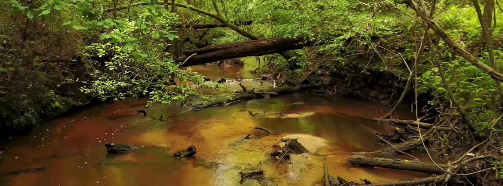
NSF NEON, Operated by Battelle

Main navigation

  • About Us
    • Overview
      • Spatial and Temporal Design
      • History
    • Vision and Management
    • Advisory Groups
      • Science, Technology & Education Advisory Committee
      • Technical Working Groups (TWGs)
    • FAQ
    • Contact Us
      • Contact NEON Biorepository
      • Field Offices
    • User Accounts
    • Staff
    • Code of Conduct

    About Us

  • Data & Samples
    • Data Portal
      • Explore Data Products
      • Data Availability Charts
      • Spatial Data & Maps
      • Document Library
      • API & GraphQL
      • Prototype Data
      • External Lab Data Ingest (restricted)
    • Data Themes
      • Biogeochemistry
      • Ecohydrology
      • Land Cover and Processes
      • Organisms, Populations, and Communities
    • Samples & Specimens
      • Discover and Use NEON Samples
        • Sample Types
        • Sample Repositories
        • Sample Explorer
        • Megapit and Distributed Initial Characterization Soil Archives
      • Sample Processing
      • Sample Quality
      • Taxonomic Lists
    • Collection Methods
      • Protocols & Standardized Methods
      • Airborne Remote Sensing
        • Flight Box Design
        • Flight Schedules and Coverage
        • Daily Flight Reports
          • AOP Flight Report Sign Up
        • Camera
        • Imaging Spectrometer
        • Lidar
      • Automated Instruments
        • Site Level Sampling Design
        • Sensor Collection Frequency
        • Instrumented Collection Types
          • Meteorology
          • Phenocams
          • Soil Sensors
          • Ground Water
          • Surface Water
      • Observational Sampling
        • Site Level Sampling Design
        • Sampling Schedules
        • Observation Types
          • Aquatic Organisms
            • Aquatic Microbes
            • Fish
            • Macroinvertebrates & Zooplankton
            • Periphyton, Phytoplankton, and Aquatic Plants
          • Terrestrial Organisms
            • Birds
            • Ground Beetles
            • Mosquitoes
            • Small Mammals
            • Soil Microbes
            • Terrestrial Plants
            • Ticks
          • Hydrology & Geomorphology
            • Discharge
            • Geomorphology
          • Biogeochemistry
          • DNA Sequences
          • Pathogens
          • Sediments
          • Soils
            • Soil Descriptions
        • Optimizing the Observational Sampling Designs
    • Data Notifications
    • Data Guidelines and Policies
      • Acknowledging and Citing NEON
      • Publishing Research Outputs
      • Usage Policies
    • Data Management
      • Data Availability
      • Data Formats and Conventions
      • Data Processing
      • Data Quality
      • Data Product Bundles
      • Data Product Revisions and Releases
        • Release 2021
        • Release 2022
        • Release 2023
        • Release 2024
        • Release-2025
      • NEON and Google
      • Externally Hosted Data

    Data & Samples

  • Field Sites
    • About Field Sites and Domains
    • Explore Field Sites
    • Site Management Data Product

    Field Sites

  • Impact
    • Observatory Blog
    • Case Studies
    • Papers & Publications
    • Newsroom
      • NEON in the News
      • Newsletter Archive
      • Newsletter Sign Up

    Impact

  • Resources
    • Getting Started with NEON Data & Resources
    • Documents and Communication Resources
      • Papers & Publications
      • Document Library
      • Outreach Materials
    • Code Hub
      • Code Resources Guidelines
      • Code Resources Submission
      • NEON's GitHub Organization Homepage
    • Learning Hub
      • Science Videos
      • Tutorials
      • Workshops & Courses
      • Teaching Modules
    • Research Support Services
      • Field Site Coordination
      • Letters of Support
      • Mobile Deployment Platforms
      • Permits and Permissions
      • AOP Flight Campaigns
      • Research Support FAQs
      • Research Support Projects
    • Funding Opportunities

    Resources

  • Get Involved
    • Advisory Groups
      • Science, Technology & Education Advisory Committee
      • Technical Working Groups
    • Upcoming Events
    • NEON Ambassador Program
      • Exploring NEON-Derived Data Products Workshop Series
    • Research and Collaborations
      • Environmental Data Science Innovation and Inclusion Lab
      • Collaboration with DOE BER User Facilities and Programs
      • EFI-NEON Ecological Forecasting Challenge
      • NEON Great Lakes User Group
      • NEON Science Summit
      • NCAR-NEON-Community Collaborations
        • NCAR-NEON Community Steering Committee
    • Community Engagement
      • How Community Feedback Impacts NEON Operations
    • Science Seminars and Data Skills Webinars
      • Past Years
    • Work Opportunities
      • Careers
      • Seasonal Fieldwork
      • Internships
        • Intern Alumni
    • Partners

    Get Involved

  • My Account
  • Search

Search

Field Sites

  • About Field Sites and Domains
  • Explore Field Sites
  • Site Management Data Product

Breadcrumb

  1. Field Sites
  2. Mayfield Creek NEON

Field Site

Mayfield Creek NEON / MAYF

blue square white drop icon

Core Aquatic, AL, D08: Ozarks Complex

Mayfield Creek aquatic site in Domain 08, the Ozarks

About Field Sites

Mayfield Creek (MAYF) is an aquatic NEON field site in the coastal plain of west-central Alabama. The site has a watershed size of 14.3 km2 (3534 acres) and is encompassed within the Mobile River Basin. This site is also located in the Talladega National Forest and is managed by the U.S. Forest Service. The forest consists of mixed mature coniferous and hardwood trees, and wetlands comprise a significant portion of the watershed. MAYF is part of NEON's Ozarks Complex Domain (D08). D08 includes two other aquatic field sites and three terrestrial sites. MAYF is colocated with the terrestrial site TALL. [1] [3]

Climate

Alabama has a subtropical climate with hot summers, mild winters, and year-round precipitation. Summers are hot and humid, dominated by maritime tropical air from the Gulf of Mexico and the Atlantic. This warm, moist air contributes to the formation of convection storms and thunderstorms in the region, causing major precipitation pulses and flooding. The area is subject to tornadoes and hurricanes. The mean average annual temperature 17.2°C (63°F) and the average annual precipitation is about 1378 mm (54.3 in.). [5] [6]

Geology

The parent materials at MAYF consist of undifferentiated marine sediments of the Cretaceous age Tuscaloosa Group. In particular they are characterized by the Gordo and Coker Formations containing sand, clay, and mudstone. [2] [4]

Soils

Talladega National Forest soils are primarily sand, clay, and mudstone from the Typic Hapludults soil subgroup. Parent materials are undifferentiated marine segments from the Tuscaloosa Group, dating to the Cretaceous age. These marine sediments include Boswell, Boykin, Coldwell, Conecuh, Luverne, Maubila, Smithdale, Wadley, and Wilcox. Soils, as a result of this composition, are dominantly varicolored and sandy, loamy, and clayey. Some soils within the Talladega Forest also have a hardened bedrock of ironstone. [1] [4]

Hydrology

Mayfield Creek's stream channel is highly sinuous with many sharp, meandering bands and few straight reaches. The flow regime is typical of forested streams in the southeast. Base flows are highest in the winter and spring (February through May) and lowest in the late summer and fall (July through November). Precipitation-driven high flow events may occur at any point during the year, though wetlands likely attenuate the intensity of floods. Although the banks and channel of Mayfield Creek are comprised of sand, the vegetation appears to provide significant stability and resistance to bank failure. Mayfield is a small stream, 4.5-6 m (15-20 ft.) across and just a few feet deep. It runs into a larger stream that eventually enters into the Black Warrior River, part of the Black Warrior-Tombigbee watershed that ultimately flows into the Gulf of Mexico. [1]

Vegetation

Vegetation in the Mayfield Creek watershed consists of mature growth hardwood and conifer trees. Dominant species include various pines: longleaf (Pinus palustris), shortleaf (P. echinata), and loblobby (P. taeda). Other dominant species include oak (Quercus spp.), hickory (Carya spp.), sweetgum (Liquidambar styraciflua), tulip poplar (Liriodendron tulipifera), and dogwood (Cornus spp.). Ground cover vegetation is well-developed but not particularly obstructive. Understory vegetation includes ferns, shrubs, immature trees, and vines. Poison ivy is very common throughout the understory. [1] [3] [4]

Fauna

The Talladega National Forest and associated wetlands support a wide variety of insect, bird, reptile, amphibian, and mammal species. In 2004, the forest was deemed essential habitat for the endangered red-cockaded woodpecker (Leuconotopicus borealis) and associated species Bachman's sparrow (Peucaea aestivalis), bobwhite quail (Colinus virginianus), and prairie warbler (Setophaga discolor).The stream is important habitat for many amphibian and reptile species, including the threatened flattened musk turtle (Sternotherus depressus). Within the Cahaba watershed, there are 20 endangered species of fishes, mussels, and crayfish; 15 more species are threatened; and 17 more species are vulnerable. Endangered and threatened mussel species at Mayfield Creek include the orangenacre mucket (Hamiota perovalis), Alabama moccasinshell (Medionidus acutissimus), and the inflated heelsplitter (Potamilus inflatus). [7] [8] [9]

Past Land Management and Use

Native American presence in the area dates back at least 12,000 years ago. When European explorers and settlers arrived in the 1600s, four major native nations were living in Alabama: Cherokee, Creek, Chickasaw, and Choctaw. Following the 1830 Indian Removal Act, the U.S. used forced treaties to relocate these indigenous peoples. During the 1800s, the forests throughout Alabama were extensively logged, destroying most of the old growth forests in the state, and was heavily impacted by agriculture. By the early 1900s, most of central Alabama was deforested and intensive farming had resulted in heavy erosion and nutrient depletion. In 1935, the National Forest Commission purchased around 1135 km2 (280,400 acres) of cut-over land as part of the Oakmulgee Purchase Unit, with the intention of reseeding the forests for managed logging, wildlife protection, and recreation. In 1936, President Roosevelt created the Talladega National Forest by proclamation, combining the Oakmulgee Purchase Unit and the Talladega Purchase Unit into protected forestland. By the time the Oakmulgee District was incorporated into the Talladega National Forest, it had already been cut over twice, and desired species were not restocking. The Forest Service's early developments were focused on forestry, upland game, and recreation. Fire management infrastructure included access roads and lookout towers, fire breaks, and the establishment of a fire protection patrol. Many of these structures remain scattered throughout the forest. The University of Alabama also conducts ongoing research in the damaged area. [10] [11] [12] [13] [16] [17] [18]

Current Land Management and Use

The site host for Talladega National Forest is the U.S. Forest Service. The mission of USFS is to sustainably manage the nation's forests to meet the needs of present and future generations. Management practices for the watershed at Talladega National Forest includes annual surveys for baseline aquatic species distribution and habitat conditions, development of inventory maps for non-native and invasive species, creation of endangered species protection programs, and protection of riparian vegetation via the elimination of pesticides and clear-cut management practices within riparian boundaries. A revised management plan published in 2004 listed sedimentation as the leading cause of water quality degradation within Alabama National Forest boundaries, as a result of poor forestry and agricultural practices. As a result, current practices within the Talladega National Forest aim to reduce overall loss of riparian vegetation and increase habitat suitability for sensitive species. Current land use is predominantly recreation (hiking, fishing, boating, camping and hunting). Some areas, including the land that TALL and MAYF occupy, are set aside for wildlife preservation. Limited logging is permitted in some parts of the Talladega National Forest. [7] [8] [11] [14] [15]

NEON Site Establishment

NEON site establishment at Mayfield Creek began in September 2014 with a site survey, which generated a site characterization report (see NEON.DOC.001370). A dry run of operations ran through December 2015, when the site transitioned to full operation. AIS sensors were built in February 2016.

Additional Resources

[1] Aquatic Instrument System (AIS) Site Characterization Report: Domain 08. NEON.DOC.001370vB.

[2] U.S. Geological Survey, 2005, Mineral Resources Data System: U.S. Geological Survey, Reston, Virginia. https://mrdata.usgs.gov/mrds/

[3] Terrestrial Observation System (TOS) Site Characterization Report: Domain 08. NEON.DOC.003892vB.

[4] NEON Site-Level Plot Summary Talladega National Forest (TALL) (Hatchner, C. (2017). NEON site-level plot summary: Talladega National Forest (TALL). USDA.

[5] PRISM Climate Group, Oregon State University, http://prism.oregonstate.edu,created 4 Feb 2004.

[6] https://statesummaries.ncics.org/chapter/al/

[7] National Forest Service Alabama. (2015). Review of National Forests in Alabama's Revised Land and Resource Management Plan: Year-in-10 Review. USDA and U.S. Forest Service. https://fs.usda.gov/Internet/FSE_DOCUMENTS/stelprd3856715.pdf.

[8] Jacobs, R. (2004). Revised Land and Resource Management Plan: National Forests in Alabama. Management Bulletin R8-MB 112A. USDA: Forest Service Southern Region. https://www.fs.usda.gov/Internet/FSE_DOCUMENTS/fsbdev3_002528.pdf.

[9] Elkins, D. C., Sweat, S. C., Hill, K. S., Kuhajda, B. R., George, A. L., & Wenger, S. J. (2016). The Southeastern Aquatic Biodiversity Conservation Strategy. University of Georgia River Basin Center: Athens, GA. 237 p. http://southeastfreshwater.org/wp-content/uploads/2016/12/SE_Aquatic_Bi….

[10] Pasquill Jr., R. G. (n.d.). Talladega Ranger District: History. USDA and U.S. Forest Service: National Forests in Alabama. https://www.fs.usda.gov/detail/alabama/about-forest/districts/?cid=fsbd….

[11] https://www.fs.usda.gov/Internet/FSE_DOCUMENTS/fseprd587006.pdf

[12] National Park Service: https://www.nps.gov/articles/the-trail-of-tears-and-the-forced-relocati…

[13] Kleinman, J. S., & Hart, J. L. (2018). Vascular flora of longleaf pine woodlands after wind disturbance and salvage harvesting in the Alabama Fall Line Hills. Castanea, 83(2), 183-195.

[14] About the Agency. (n.d.). USDA and U.S. Forest Service: National Forests in Alabama. https://www.fs.usda.gov/about-agency.

[15] Today: Research & Product Development. (n.d.). USDA and U.S. Forest Service: National Forests in Alabama. https://www.fs.fed.us/forestmanagement/aboutus/today/shtml.

[16] Walthall, J. A. (1990). Prehistoric Indians of the Southeast: archaeology of Alabama and the Middle South. University of Alabama Press.

[17] Rogers, W.W., Ward, R.D., Atkins, L.R., & Flynt, W. (2018). Alabama: The History of a Deep South State, Bicentennial Edition. (Bicentennial edition. ed.). Tuscaloosa: The University of Alabama Press. muse.jhu.edu/book/60678.

[18] Doster, J. F., & Weaver, D. C. (1981). Historic Settlement in the Upper Tombigbee Valley. Alabama University in Birmingham Center for the Study of Southern History and Culture.


Field Site Information

Latitude/Longitude

32.960365, -87.407688

Geodetic Datum

WGS84

Location

Bibb County
AL, US

Elevation

Mean: 77m

Mean Annual Temperature

17.2°C

Dominant NLCD Classes

Deciduous Forest, Mixed Forest

Colocated Site(s)

Talladega National Forest NEON

Field Operations Office

6050 Mimosa Circle, Suite C
Tuscaloosa, AL 35405

Research Access

Non-NEON research activities are allowed in this area. Researchers must obtain their own permits with the site host(s).

Request Access

Observation Types

Remote Sensing

Remote sensing surveys of this field site collect lidar, spectrometer and high-resolution RGB camera data.

Meteorological Measurements

This site has one meteorological station located in the riparian area. The met station is outfitted with a subset of the same sensors used at terrestrial sites. Measurements include wind speed and direction, air temperature, barometric pressure, relative humidity, shortwave radiation, and PAR.

Phenocams

A phenocam is pointed toward the land-water interface of the site. Here we show the images from the most recent hour. The full collection of images can be viewed on the Phenocam Gallery - click on the image below.

NEON.D08.MAYF.DP1.20002


Field Site Data

Site

Site Host

Talladega National Forest

Site Access Allowed

Yes

Site URL

https://www.fs.usda.gov/detail/alabama/about-forest/districts/?cid=fsbdev3_002555

Site Access Details

Researchers should coordinate directly with the US Forest Service for permitting and approval.

Operations Office

NEON Field Operations Office

Domain 08 Support Facility

NEON Field Operations Address

6050 Mimosa Circle, Suite C
Tuscaloosa, AL 35405

NEON Field Operations Phone

205.409.9039

Location

Latitude

32.960365

Longitude

-87.407688

Geodetic Datum

WGS84

UTM Northing

3646888.45m

UTM Easting

461856.89m

UTM Zone

16N

County

Bibb

State

AL

Country

US

Mean Elevation

77m

Climate

Mean Annual Temperature

17.2°C

Mean Annual Precipitation

1379mm

Vegetation

Dominant NLCD Classes

Deciduous Forest, Mixed Forest

Watershed

USGS HUC

h03160113

Watershed Name

Lower Black Warrior

Geology

USGS Geology Unit

ALKg;1

USGS Geology Name

Tuscaloosa Group; Gordo Formation

USGS Lithologic Constituents

Beds of cross-bedded sand, gravelly sand, and lenticular beds of clay; lower part is predominantly a gravelly sand consisting chiefly of chert and quartz pebbles.

USGS Geology Age

Cretaceous


Gallery

  • Photos
  • Videos

No Video


Related Field Sites

Other Domain D08 Field Sites

blue circle white drop icon Black Warrior River NEON
Gradient Aquatic
brown circle white drop icon Dead Lake NEON
Gradient Terrestrial
brown circle white drop icon Lenoir Landing NEON
Gradient Terrestrial
blue circle white drop icon Lower Tombigbee River NEON
Gradient Aquatic
brown square white mountain icon Talladega National Forest NEON
Core Terrestrial

Other Field Sites in AL

blue circle white drop icon Black Warrior River NEON
Gradient Aquatic
brown circle white drop icon Dead Lake NEON
Gradient Terrestrial
brown circle white drop icon Lenoir Landing NEON
Gradient Terrestrial
blue circle white drop icon Lower Tombigbee River NEON
Gradient Aquatic
brown square white mountain icon Talladega National Forest NEON
Core Terrestrial
NSF NEON, Operated by Battelle

Follow Us:

Join Our Newsletter

Get updates on events, opportunities, and how NEON is being used today.

Subscribe Now

Footer

  • About Us
  • Newsroom
  • Contact Us
  • Terms & Conditions
  • Careers
  • Code of Conduct

Copyright © Battelle, 2025

The National Ecological Observatory Network is a major facility fully funded by the U.S. National Science Foundation.

Any opinions, findings and conclusions or recommendations expressed in this material do not necessarily reflect the views of the U.S. National Science Foundation.