Yellowstone National Park NEON (YELL) Soil Descriptions
Distributed Soils Reports
Pedon Descriptions
Pit‐level observations and field measurements reported using the standard NRCS format. They contain volume estimates for coarse fragments > 20 mm where applicable.
Site Level Plot Summary
A narrative summary that places the sampled soil pedons in the broader context of soils and geomorphology for the entire NEON site.
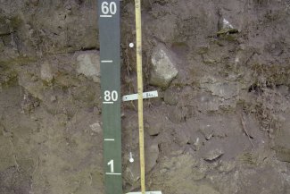
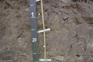
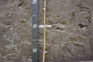
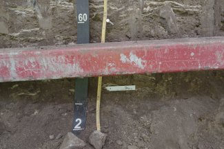
Megapit Images
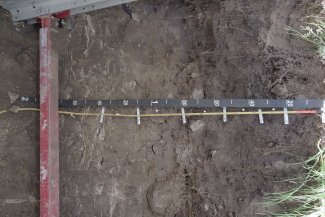
D12 YELL megapit soil profile 0-200 cm
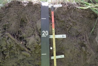
D12 YELL megapit soil profile 0-39 cm
D12 YELL megapit soil profile 22-52 cm
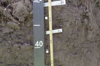
D12 YELL megapit soil profile 37-80 cm
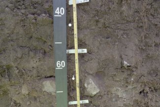
D12 YELL megapit soil profile 59-109 cm
D12 YELL megapit soil profile 89-140 cm
D12 YELL megapit soil profile 120-170 cm
D12 YELL megapit soil profile 156-200 cm
Megapit Pedon Description
| Print Date | Feb 4 2019 |
|---|---|
| Description Date | Jul 10 2018 |
| Describer | Daniel Wood, Philip Goodin |
| Site ID | S2018WY029001 |
| Pedon ID | S2018WY029001 |
| Lab Source ID | KSSL |
| Lab Pedon # | 18N1800 |
| Soil Name as Described/Sampled | Pachel |
| Classification | Fine-loamy, mixed, superactive, frigid Pachic Argiustolls |
| Pedon Type | confirmation description |
| Pedon Purpose | laboratory sampling site |
| Taxon Kind | family |
| Physiographic Division | Rocky Mountain System |
| Physiographic Province | Middle Rocky Mountains |
| Geomorphic Setting | on footslope of mountainbase of mountains on footslope of mountainbase of hillslope |
| Upslope Shape | concave |
| Cross Slope Shape | linear |
| Particle Size Control Section | 4 to 29 cm. |
| Description origin | Spreadsheet |
| State | Wyoming |
| County | Park |
| MLRA | 43B -- Central Rocky Mountains |
| Soil Survey Area | WY665 -- Yellowstone National Park, Wyoming-Montana-Idaho 4-POW -- Powell, Wyoming |
| Quad Name | Blacktail Deer Creek, Wyoming |
| Std Latitude | 44.9559710 |
| Std Longitude | -110.5419840 |
| Latitude | 44 degrees 57 minutes 21.50 seconds north |
| Longitude | 110 degrees 32 minutes 31.14 seconds west |
| Datum | NAD83 |
| UTM Zone | 12 |
| UTM Easting | 536126 meters |
| UTM Northing | 4978161 meters |
| Primary Earth Cover | Grass/herbaceous cover |
| Description database | KSSL |
| Diagnostic Features | mollic epipedon 0 to 98 cm. argillic horizon 4 to 29 cm. argillic horizon 45 to 200 cm. secondary carbonates 67 to 200 cm. |
| Slope (%) | 9.0 |
| Elevation (meters) | 2,036.0 |
| Aspect (deg) | 343 |
| MAAT (C) | 6.0 |
| MAP (mm) | 432 |
| Frost-Free Days | 100 |
| Drainage Class | well |
| Horizon Details |
A--0 to 4 centimeters (0.0 to 1.6 inches); brown (7.5YR 4/2) broken face loam, black (7.5YR 2.5/1) broken face, moist; 20 percent clay; moderate medium granular structure; soft, friable, slightly sticky, slightly plastic; very fine roots throughout and fine roots throughout; 2 percent nonflat subangular indurated 2 to 5-millimeter mixed rock fragments; noneffervescent, by HCl, 1 normal; neutral, pH 7.2, pH indicator solutions; clear smooth boundary. Lab sample # 18N05260 Bt1--4 to 29 centimeters (1.6 to 11.4 inches); brown (7.5YR 4/2) broken face loam, black (7.5YR 2.5/1) broken face, moist; 24 percent clay; moderate medium subangular blocky structure; soft, very friable, slightly sticky, slightly plastic; very fine roots throughout and fine roots throughout; very fine low-continuity dendritic tubular and fine low-continuity dendritic tubular pores; 15 percent distinct clay films on all faces of peds; 4 percent nonflat subangular indurated 2 to 20-millimeter mixed rock fragments and 4 percent nonflat subangular indurated 2 to 5-millimeter mixed rock fragments; noneffervescent, by HCl, 1 normal; neutral, pH 6.8, pH indicator solutions; gradual wavy boundary. Lab sample # 18N05261 Bw--29 to 45 centimeters (11.4 to 17.7 inches); brown (7.5YR 4/2) broken face loam, black (7.5YR 2.5/1) broken face, moist; 24 percent clay; weak medium granular structure; soft, very friable, moderately sticky, moderately plastic; very fine roots throughout and fine roots throughout; very fine low-continuity dendritic tubular pores; 3 percent nonflat subangular indurated 2 to 20-millimeter mixed rock fragments and 4 percent nonflat subangular indurated 2 to 5-millimeter mixed rock fragments; noneffervescent, by HCl, 1 normal; neutral, pH 6.8, pH indicator solutions; gradual smooth boundary. Lab sample # 18N05262 Bt2--45 to 67 centimeters (17.7 to 26.4 inches); brown (7.5YR 4/2) broken face gravelly loam, black (7.5YR 2.5/1) broken face, moist; 26 percent clay; moderate medium subangular blocky structure; soft, friable, moderately sticky, moderately plastic; very fine roots throughout and fine roots throughout; very fine moderate-continuity dendritic tubular and fine low-continuity dendritic tubular pores; 25 percent distinct clay films on all faces of peds; 5 percent nonflat subangular indurated 2 to 20-millimeter mixed rock fragments and 10 percent nonflat subangular indurated 2 to 5-millimeter mixed rock fragments; noneffervescent, by HCl, 1 normal; neutral, pH 7.0, pH indicator solutions; gradual wavy boundary. Lab sample # 18N05263 Btk1--67 to 98 centimeters (26.4 to 38.6 inches); brown (7.5YR 5/2) broken face gravelly clay loam, dark brown (7.5YR 3/2) broken face, moist; 28 percent clay; moderate medium subangular blocky structure; moderately hard, friable, moderately sticky, moderately plastic; very fine roots throughout and medium roots throughout and fine roots throughout; very fine moderate-continuity dendritic tubular pores; 10 percent faint carbonate coats on rock fragments and 35 percent distinct clay films on all faces of peds; 2 percent medium distinct cylindrical indurated cemented carbonate nodules with clear boundaries in matrix; 5 percent nonflat subrounded indurated 250 to 600-millimeter mixed rock fragments and 5 percent nonflat subangular indurated 5 to 20-millimeter mixed rock fragments and 8 percent nonflat subangular indurated 2 to 5-millimeter mixed rock fragments and 8 percent nonflat subrounded indurated 76 to 250-millimeter mixed rock fragments and 8 percent nonflat subangular indurated 20 to 76-millimeter mixed rock fragments; noneffervescent, by HCl, 1 normal; neutral, pH 7.2, pH indicator solutions; gradual wavy boundary. Lab sample # 18N05264 Btk2--98 to 126 centimeters (38.6 to 49.6 inches); light brown (7.5YR 6/3) broken face gravelly clay loam, brown (7.5YR 5/3) broken face, moist; 28 percent clay; moderate medium subangular blocky structure; moderately hard, friable, moderately sticky, moderately plastic; very fine roots throughout and fine roots throughout; very fine low-continuity tubular pores; 15 percent distinct carbonate coats on rock fragments and 40 percent distinct clay films on all faces of peds; 3 percent medium distinct irregular weakly cemented carbonate masses with diffuse boundaries in matrix; 2 percent nonflat subrounded indurated 250 to 600-millimeter mixed rock fragments and 2 percent nonflat subrounded indurated 76 to 250-millimeter mixed rock fragments and 3 percent nonflat subangular indurated 20 to 76-millimeter mixed rock fragments and 4 percent nonflat subangular indurated 2 to 5-millimeter mixed rock fragments and 5 percent nonflat subangular indurated 5 to 20-millimeter mixed rock fragments; very slight effervescence, by HCl, 1 normal; slightly alkaline, pH 7.6, pH indicator solutions; gradual wavy boundary. Lab sample # 18N05265 Btk3--126 to 161 centimeters (49.6 to 63.4 inches); light gray (10YR 7/2) broken face clay loam, brown (10YR 5/3) broken face, moist; 30 percent clay; moderate medium platy parts to moderate medium subangular blocky structure; moderately hard, friable, moderately sticky, moderately plastic; fine low-continuity tubular pores; 35 percent distinct clay films on all faces of peds and 40 percent distinct carbonate coats on bottom of rock fragments; 35 percent medium prominent threadlike weakly cemented carbonate masses with clear boundaries in matrix; 3 percent nonflat subangular indurated 20 to 76-millimeter mixed rock fragments and 3 percent nonflat subangular indurated 5 to 20-millimeter mixed rock fragments and 5 percent nonflat subangular indurated 2 to 5-millimeter mixed rock fragments; strong effervescence, by HCl, 1 normal; moderately alkaline, pH 8.2, pH indicator solutions; diffuse wavy boundary. Lab sample # 18N05266 Btk4--161 to 200 centimeters (63.4 to 78.7 inches); pale brown (10YR 6/3) broken face clay loam, brown (10YR 4/3) broken face, moist; 30 percent clay; strong medium platy structure; hard, firm, moderately sticky, moderately plastic; fine low-continuity tubular pores; 40 percent distinct carbonate coats on bottom of rock fragments and 65 percent prominent clay films on all faces of peds; 15 percent medium prominent threadlike weakly cemented carbonate masses with clear boundaries in matrix; 3 percent nonflat subangular indurated 20 to 76-millimeter mixed rock fragments and 3 percent nonflat subangular indurated 5 to 20-millimeter mixed rock fragments and 5 percent nonflat subangular indurated 2 to 5-millimeter mixed rock fragments; strong effervescence, by HCl, 1 normal; moderately alkaline, pH 8.4, pH indicator solutions. Lab sample # 18N05267 |
Credits: This megapit soil pedon description was generously created by USDA Natural Resource Conservation Service staff, with particular thanks to Larry West, Jon Hempel, and numerous field staff.