
Chase Lake National Wildlife Refuge NEON (WOOD) Soil Descriptions
Distributed Soils Reports
Pedon Descriptions
Pit‐level observations and field measurements reported using the standard NRCS format. They contain volume estimates for coarse fragments > 20 mm where applicable.
Site Level Plot Summary
A narrative summary that places the sampled soil pedons in the broader context of soils and geomorphology for the entire NEON site.
Megapit Images
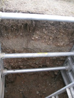
D09 WOOD megapit soil profile 0-200 cm
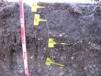
D09 WOOD megapit soil profile 0-46 cm
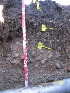
D09 WOOD megapit soil profile 5-69 cm
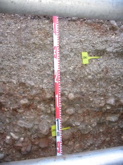
D09 WOOD megapit soil profile 57-115 cm
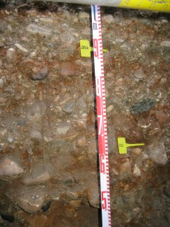
D09 WOOD megapit soil 101-159 cm
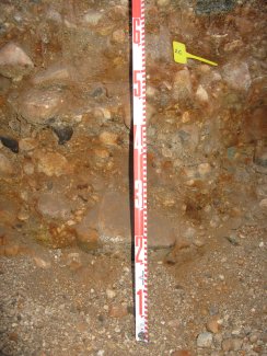
D09 WOOD megapit soil profile 137-200 cm
Megapit Pedon Description
| Print Date | Jul 22 2015 |
|---|---|
| Description Date | Sep 18 2012 |
| Describer | A. Gulsvig, B. DeFoe |
| Site ID | 12ND093001 |
| Pedon ID | S2012ND093001 |
| Lab Source ID | KSSL |
| Lab Pedon # | 12N8337 |
| Soil Name as Described/Sampled | Manning-Like |
| Pedon Purpose | research site |
| Taxon Kind | series |
| Geomorphic Setting | on backslope of side slope of outwash plain |
| Upslope Shape | linear |
| Cross Slope Shape | linear |
| Particle Size Control Section | 25 to 100 cm. |
| Description origin | Pedon PC 5.0 |
| State | North Dakota |
| County | Stutsman |
| Std Latitude | 47.1589890 |
| Std Longitude | -99.2390210 |
| Primary Earth Cover | Grass/herbaceous cover |
| Secondary Earth Cover | Other grass/herbaceous cover |
| Existing Vegetation | Kentucky bluegrass |
| Description database | KSSL |
| Diagnostic Features | mollic epipedon 0 to 32 cm. |
| Slope (%) | 2.0 |
| Aspect (deg) | 25 |
| Drainage Class | somewhat excessively |
| Horizon Details |
A--0 to 6 centimeters (0.0 to 2.4 inches); black (10YR 2/1) loam, very dark gray (10YR 3/1), dry; 24 percent clay; weak fine granular structure; soft, very friable, slightly sticky, slightly plastic; very fine roots throughout and fine roots throughout; very fine dendritic tubular pores; 3 percent nonflat 2 to 5-millimeter mixed rock fragments; noneffervescent, by HCl, 1 normal; abrupt smooth boundary. Lab sample # 12N05021 Ap--6 to 16 centimeters (2.4 to 6.3 inches); black (10YR 2/1) loam, very dark grayish brown (10YR 3/2), dry; 24 percent clay; weak medium prismatic parts to moderate medium subangular blocky structure; slightly hard, friable, slightly sticky, slightly plastic; very fine roots throughout and fine roots throughout; very fine dendritic tubular pores; 6 percent nonflat 2 to 5-millimeter mixed rock fragments; noneffervescent, by HCl, 1 normal; abrupt smooth boundary. Lab sample # 12N05022 2Bw--16 to 32 centimeters (6.3 to 12.6 inches); very dark brown (10YR 2/2) very gravelly sandy loam, dark brown (10YR 3/3), dry; 11 percent clay; loose, loose, nonsticky, nonplastic; very fine roots throughout; 10 percent distinct irregular carbonate concretions with clear boundaries on bottom of rock fragments; 50 percent nonflat 2 to 75-millimeter mixed rock fragments; noneffervescent, by HCl, 1 normal; clear wavy boundary. Lab sample # 12N05023 2Bk1--32 to 58 centimeters (12.6 to 22.8 inches); dark brown (10YR 3/3) very gravelly loamy sand, brown (10YR 4/3), dry; 3 percent clay; loose, loose, nonsticky, nonplastic; very fine roots throughout; 5 percent distinct irregular carbonate concretions on bottom of rock fragments; 55 percent nonflat 2 to 75-millimeter mixed rock fragments; strong effervescence, by HCl, 1 normal; clear wavy boundary. Lab sample # 12N05024 2Bk2--58 to 92 centimeters (22.8 to 36.2 inches); olive brown (2.5Y 4/3) very gravelly loamy sand, light yellowish brown (2.5Y 6/3), dry; 3 percent clay; loose, loose, nonsticky, nonplastic; very fine roots throughout; 5 percent distinct irregular carbonate concretions on bottom of rock fragments; 60 percent nonflat 2 to 10-millimeter mixed rock fragments; violent effervescence, by HCl, 1 normal; clear wavy boundary. Lab sample # 12N05025 2BCk--92 to 133 centimeters (36.2 to 52.4 inches); 60 percent dark brown (7.5YR 3/4) and 40 percent brown (10YR 4/3) very gravelly sand, 60 percent brown (7.5YR 4/4) and 40 percent brown (10YR 5/3), dry; loose, loose, nonsticky, nonplastic; very fine roots throughout; 10 percent distinct irregular carbonate concretions on bottom of rock fragments; 40 percent nonflat 2 to 75-millimeter mixed rock fragments; slight effervescence, by HCl, 1 normal; clear wavy boundary. Lab sample # 12N05026 2C--133 to 190 centimeters (52.4 to 74.8 inches); 60 percent dark brown (7.5YR 3/4) and 40 percent brown (10YR 4/3) very gravelly sand, 60 percent brown (7.5YR 4/4) and 40 percent brown (10YR 5/3), dry; loose, loose, nonsticky, nonplastic; 25 percent nonflat 75 to 250-millimeter mixed rock fragments and 30 percent nonflat 2 to 75-millimeter mixed rock fragments; very slight effervescence, by HCl, 1 normal. Lab sample # 12N05027 |
Credits: This megapit soil pedon description was generously created by USDA Natural Resource Conservation Service staff, with particular thanks to Larry West, Jon Hempel, and numerous field staff.