University of Notre Dame Environmental Research Center NEON (UNDE) Soil Descriptions
Distributed Soils Reports
Pedon Descriptions
Pit‐level observations and field measurements reported using the standard NRCS format. They contain volume estimates for coarse fragments > 20 mm where applicable.
Site Level Plot Summary
A narrative summary that places the sampled soil pedons in the broader context of soils and geomorphology for the entire NEON site.
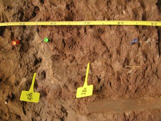
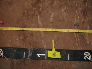
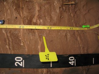
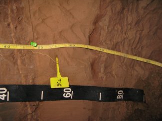
Megapit Images
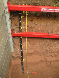
D05 UNDE megapit soil profile 0-200 cm
D05 UNDE megapit soil profile 0-110 cm
D05 UNDE megapit soil profile 0-34 cm
D05 UNDE megapit soil profile 21-61 cm
D05 UNDE megapit soil profile 43-92 cm
D05 UNDE megapit soil profile 80-120 cm
D05 UNDE megapit soil profile 113-155 cm
D05 UNDE megapit soil profile 139-195 cm
Megapit Pedon Description
| Print Date | Jul 22 2015 |
|---|---|
| Description Date | Sep 9 2013 |
| Describer | Ryan Bevernitz, Lily Palmer, J Scott Eversoll |
| Site ID | 2013MI053001 |
| Site Note | NEON site |
| Pedon ID | S2013MI053001 |
| Lab Source ID | KSSL |
| Lab Pedon # | 13N97284 |
| Soil Name as Described/Sampled | Tula |
| Classification | Coarse-loamy, mixed, superactive, frigid Argic Fragiaquods |
| Pedon Type | confirmation description |
| Pedon Purpose | research site |
| Taxon Kind | series |
| Geomorphic Setting | on backslope of side slope of disintegration moraine on till plain |
| Upslope Shape | concave |
| Cross Slope Shape | linear |
| Description origin | NASIS |
| State | Michigan |
| County | Gogebic |
| MLRA | 93B -- Superior Stony and Rocky Loamy Plains and Hills, Eastern Part |
| Soil Survey Area | 10-RHI -- Rhinelander, Wisconsin |
| Map Unit | 5172C -- Gogebic, sandy substratum-Pence-Cathro complex, 0 to 18 percent slopes |
| Quad Name | Tenderfoot Lake, Wisconsin |
| Latitude | 46 degrees 14 minutes 10.40 seconds north |
| Longitude | 89 degrees 32 minutes 20.90 seconds west |
| Datum | NAD83 |
| Primary Earth Cover | Tree cover |
| Secondary Earth Cover | Intermixed conifers and hardwoods |
| Existing Vegetation | arctic bentgrass, balsam fir, beaked hazelnut, bedstraw, big red stem moss, black cherry, bristly dewberry, bunchberry dogwood, Canada mayflower, common ladyfern, eastern marsh fern, eastern teaberry, elderberry, goldenrod, groundcedar, hawkweed, paper birch, partridgeberry, quaking aspen, rare clubmoss, red maple, sarsaparilla, sedge, speckled alder, sphagnum, starflower, western brackenfern, white spruce, woodfern, Yakima bird's-beak |
| Surface Fragments | flat subrounded indurated 250- to 600-millimeter |
| Description database | KSSL |
| Slope (%) | 4.0 |
| Elevation (meters) | 1,680.0 |
| Aspect (deg) | 270 |
| Drainage Class | somewhat poorly |
| Horizon Details |
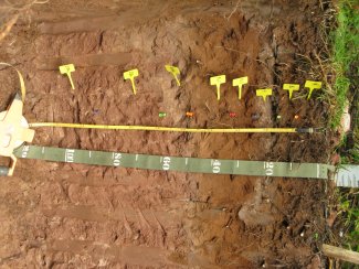
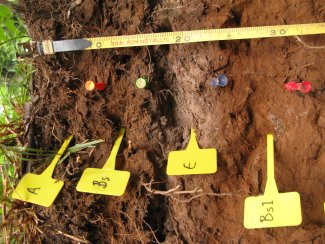
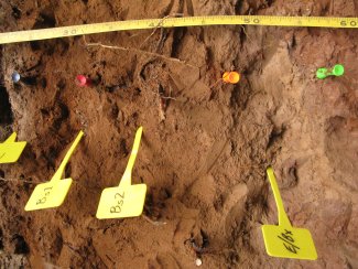
A--0 to 8 centimeters (0.0 to 3.1 inches); dark brown (7.5YR 3/3) sandy loam; weak fine granular structure; very friable; very fine roots and medium roots and fine roots and coarse roots; 3 percent nonflat subrounded indurated 76 to 250-millimeter unspecified fragments; clear smooth boundary. Lab sample # 13N12314. A and Bs might be from a tree throw Bs--8 to 15 centimeters (3.1 to 5.9 inches); brown (7.5YR 4/4) sandy loam; weak medium subangular blocky structure; very friable; very fine roots and medium roots and fine roots; clear smooth boundary. Lab sample # 13N12315 E--15 to 23 centimeters (5.9 to 9.1 inches); brown (7.5YR 5/2) sandy loam; moderate thin platy parts to moderate medium subangular blocky structure; friable; medium roots and fine roots; 35 percent distinct 5YR 5/3), moist, silt coats on all faces of peds; 1 percent medium prominent 7.5YR 5/8) masses of oxidized iron on surfaces along root channels and 10 percent medium prominent 7.5YR 5/8) masses of oxidized iron on faces of peds; clear smooth boundary. Lab sample # 13N12316. a thin a horizon at the top of the horizon B's1--23 to 31 centimeters (9.1 to 12.2 inches); dark reddish brown (5YR 3/4) fine sandy loam; strong coarse angular blocky structure; friable; very fine roots and fine roots; clear smooth boundary. Lab sample # 13N12317 B's2--31 to 48 centimeters (12.2 to 18.9 inches); brown (7.5YR 4/4) fine sandy loam; strong coarse angular blocky structure; friable; very fine roots and fine roots; clear smooth boundary. Lab sample # 13N12318 E/Bx--48 to 57 centimeters (18.9 to 22.4 inches); 60 percent reddish gray (5YR 5/2) and 40 percent reddish brown (2.5YR 4/4) fine sandy loam; strong fine subangular blocky structure; hard, firm; brittle; very fine roots and medium roots and fine roots and coarse roots; fine low-continuity vesicular pores; abrupt irregular boundary. Lab sample # 13N12319. A and Bs might be from a tree throw 2Bt1--57 to 83 centimeters (22.4 to 32.7 inches); reddish brown (2.5YR 4/4) silty clay; strong fine subangular blocky structure; very firm; fine roots; 3 percent distinct 5YR 5/3), moist, silt coats on all faces of peds and 10 percent faint 2.5YR 4/3), moist, clay films on all faces of peds; gradual wavy boundary. Lab sample # 13N12320 2Bt2--83 to 114 centimeters (32.7 to 44.9 inches); reddish brown (2.5YR 4/4) silty clay loam; strong fine subangular blocky structure; very firm; fine roots; and 3 percent distinct 5YR 5/3), moist, silt coats on all faces of peds and 10 percent faint 2.5YR 4/3), moist, clay films on all faces of peds; clear wavy boundary. Lab sample # 13N12321 2C1--114 to 147 centimeters (44.9 to 57.9 inches); reddish brown (2.5YR 4/4) silty clay loam; structureless massive; very friable; fine roots; 1 percent nonflat subrounded indurated 2 to 76-millimeter unspecified fragments; abrupt smooth boundary. Lab sample # 13N12322. few 5YR 5/3 lfs lfs strata 1cm thick on average 3C2--147 to 235 centimeters (57.9 to 92.5 inches); 60 percent red (2.5YR 4/6) and 30 percent dark red (2.5YR 3/6) and 10 percent weak red (10R 4/4) stratified loamy fine sand to fine sandy loam to silt loam; structureless massive; very friable; very fine roots and fine roots; . Lab sample # 13N12323 |
Credits: This megapit soil pedon description was generously created by USDA Natural Resource Conservation Service staff, with particular thanks to Larry West, Jon Hempel, and numerous field staff.